Please note that until further notice all lectures will be held online via Zoom due to coronavirus. We will be sending out an invitation email with instructions about how to join on the day of each talk. Keep an eye open for them!
Belated AGM
The Annual General Meeting (AGM) for HADAS is normally held in June two months after the Society’s year end on 31st March of any given year. However, the June AGM for 2020 had to be postponed due to the Covid-19 lockdown.
The society is required to submit its report and audited accounts to the Charity Commissioners by the end of January 2021, hence a proforma AGM will be held on 12th January 2021 to approve the report and accounts.
Notice of the delayed 59th Annual General Meeting of the Society, due to the Coronavirus pandemic, from Tuesday 9th June 2020 to Tuesday 12th January 2021, which will be conducted as an event using Zoom at 7.15 for 7.30pm.
AGENDA
Chairman’s welcome and opening comments.
1)Apologies for absence.
2) Approve the minutes of 11th June 2019.
3)Approve the Committee’s reports and audited accounts.
4) Approve the appointment of Stewart Wild as Independent Examiner of the Society’s accounts
1
The lockdown has restricted our activities this year. As we look forward, it would benefit the Society to have more and perhaps newer members on the committee to help build our future. We are currently below full strength as permitted by our constitution and rules.
Anybody considering becoming a member of the Committee can complete a nomination form below and send it to the Secretary by post or email to arrive by 5th January.
The details should be returned to the Hon. Secretary, Jo Nelhams, 61 Potters Road, Barnet Herts EN5 5HS by post or email to be received not later than 7 days before the Annual General Meeting.
Following the AGM there will be a talk by Dr Bly Straube – Senior Curator at Jamestown Settlement, Virginia, USA. Entitled “Surprises from the Soil: Archaeological Discoveries at 17th-Century Jamestown, Virginia.” Most of the primary source materials for 17th-century Virginia in the way of maps, manuscripts, and other documents have been identified through the centuries and have been used by historians to interpret life in England’s first successful transatlantic settlement that began at Jamestown in 1607. Archaeology, especially excavations over the past quarter century, has been providing new and compelling information that has prompted fresh ideas about the past. This presentation will focus on the archaeological discoveries at Jamestown since 1994 and the true “surprises from the soil.”
HADAS October Lecture BY ZOOM Jim Nelhams
Since the lockdown began in March, we have not been able to stage lectures at Avenue House. The lecture on Tuesday 13th October by Les Capon came as a first – being delivered by Zoom. Apologies to those members who do not have the technology to watch, but it is surely preferable to reach as many of our members as we can. Also, the lecture was recorded and is
2
available on the HADAS YouTube channel which is available to HADAS members only. The lecture URL should not be passed to any non-members but is available to those members that were unable to view the original lecture.
As a singer, I’ve taken part in many concerts and on occasions have suspected that the critics were not actually there, so I must confess that I was not at the first showing, and this write-up is only possible because of the recording.
The subject of the evening was “Excavations at Eastcote House Gardens: 2012 – 2017” and the lecturer was Les Capon of AOC Archaeology Group.
The excavations were possible with lottery funding to allow digging for a month each year for 5 years. There was no work in 2013. Volunteers came from Friends of Eastcote Gardens and other local groups and schools. Over the years, more than 300 volunteers took part with up to 40 at any one time.
The first records of a house were in 1494 in a will, but pottery indicates a start date between 1200 and 1350. Most of the residents since 1494 are known. The will mentions two closes, Hopkytts (later Hopkyttes) and Droker.
Around 1600, Hopkytts had been flattened and a new larger Eastcote House built on the site. Eastcote House was declared derelict in the 1960s and demolished with the demolition rubble bulldozed into the cellars. A medieval stable block remains, which was converted in the 1960s to become a snooker hall, with the upper floor being removed nicely showing the timber frame of the building.
Of Eastcote House, some pictures remain, and a helpful floor plan had been drawn during a survey in 1936 by the Royal Commission on the Historical Monuments of England. The cellar spaces proved to be rich in remains of the building structure including a large number of nails. Some finds from Hopkytts were found dumped in a ditch. Most of the finds will be housed in a new museum in Hillingdon.
In the later digs, a further building was found within the park area. Was this Droker? It gave the appearance of being a smithy.
The park staff have laid out the footprint of Eastcote House using brick and stone so that people can see the location. More historical information can be found at https://eastcotehousegardens.weebly.com/history.html There are also some pictures of the digs in Photos section.
The “attendance” at this meeting was similar to our face-to-face lectures, and some members who might not normally be able to reach Avenue House were able to join in.
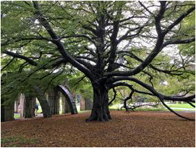
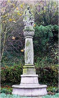
An Interesting Tree – UpdateSylvia Javes
Last year when we visited South Wales for our HADAS trip, I was intrigued by a wonderful tree at Margam Park near Port Talbot. I researched it and wrote about it for the HADAS newsletter –published in the December edition. This was a Cut-leaf or Fern-Leaf Beech situated in the ruined Chapter House of Margam Abbey. The tree is enormous and takes up most of the space of the Chapter House.
Fast forward to summer this year, when the Woodland Trust were inviting members of the public to vote for the ‘Tree of the Year’ for England, Wales, and Scotland. I noted that the Margam Abbey tree was nominated for Wales, so I voted for it. I am delighted to say that it won.
3
Llinos Humphreys from the Woodland Trust Wales said:
‘An historic fern-leaved beech enveloping the remains of one of the first Cistercian abbeys in Wales has been crowned Wales Tree of the Year 2020.
The Chapter House Tree beat off competition from five other finalists in an online vote run by Coed Cadw, the Woodland Trust in Wales.
Located within Margam Park, Port Talbot its canopy has provided shelter to visitors for many years – from Victorian tea parties to a favourite summer picnic spot for present day visitors. David Elward, who nominated the tree, said:
“I’ve been visiting Margam Park since I was a schoolboy, and this famous beech tree has been a reliable constant. Standing under its sweeping canopy, adjacent to the 12th Century Cistercian monastery and ruins, feels like you’re in a secret and magically historic space – nature’s version of a ‘cwtch’*. It’s one of my favourite places to photograph.”
It seems David isn’t alone, with the tree providing an atmospheric backdrop featuring in TV and film productions from Dr Who and Songs of Praise with Sir Bryn Terfel to the recent Netflix blockbuster series Sex Education.
The winning tree will receive a £1000 Care Award thanks to players of People’s Postcode Lottery. This can be spent on work to improve its health, signage or a public celebration.’
* cwtch- a cuddle or hug
4
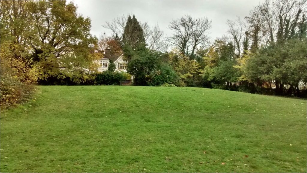
Finchley Way Open SpaceBill Bass
The Friends of Finchley Way Open Space (FoFWOS) have been in touch with us on proposals to landscape an area where ‘Brent Lodge’ once stood near Nether St and Finchley Way, West Finchley. The space is owned by Barnet Council and FoFWOS help to maintain it. In the past HADAS have done fieldwork there digging several trenches in the 1970s in an effort to discover evidence for a building which predated the lodge. This earlier structure was built c1612 and demolished c1807. Early 17th century pottery was found to indicate this structure lay nearby.
Brent Lodge itself was built in 1810 by a local benefactor, being pulled down in 1962. The site also contains a ‘wooded’ area which once formed a kitchen garden and orchard that later became allotments.
So FoFWOS have borrowed the HADAS files to copy and digitise them. There is an idea for HADAS to return for further fieldwork next year in lieu of the landscaping. The proposal leaflet and more of the interesting history of this site is available here (www.fofwos.org).
The site today looking east, the houses of ‘The Drive’ are visible with Nether St beyond them. This shows the Brent Lodge ‘house-platform’ with the wooded area to the left. Note the fairly sharp change in levels – should be interesting to survey.
5
But is it Art? David Willoughby
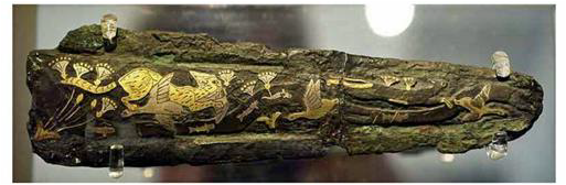
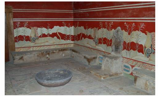
Scholars of the Aegean Bronze Age often discuss whether Bronze Age people had the concept of art in the same sense that we do. The Collins dictionary concisely defines the term ‘art’ as ‘consisting of paintings, sculpture, and other pictures or objects which are created for people to look at and admire or think deeply about’. We know that Aegean bronze age peoples produced objects and paintings that we today admire and think deeply about such as the grave goods from the shaft graves at Mycenae or the frescos found in Minoan and Theran ‘palaces’ and buildings but we have no way of knowing that these peoples regarded them in the same light. It is entirely possible that Bronze Age ‘art’ was produced solely for ritualistic or religious purposes or to merely reflect the status of an individual or group of people.
(A gold inlaid sword blade from Mycenae grave circle A depicting a cat hunting birds. 16thC BCE)
The Bronze Age texts that we can read (Mycenaean Linear B, Hittite cuneiform tablets for example) are for the most part to do with administration or religious rituals and do not touch on abstract concepts like “art”.
(The throne room at Knossos, decorated with frescos with griffin motif. Minoan 15thC BCE)
6
Excavations in Greece at Pylos by the University of Cincinnatti commencing 2015 have uncovered the ‘Grave of the Griffin Warrior’ (so called because of the griffin iconography on some the grave goods). This early Mycenaean grave of a 5ft stocky warrior dating from the 15thC BCE is unusual for the area in being a shaft grave rather than a beehive shaped Tholos tomb and for this reason it has remained untouched by tomb robbers. This grave is remarkable not only because of the richness and quantity of grave goods but also because of the how they demonstrate the influence that Minoan culture and beliefs had on Mycenaeans at this time. Many of the objects although beautiful, clearly depict religious motifs but there is one seal stone that is exquisite and depicts three warriors in combat. Although a practical object which perhaps this warrior used to mark his ownership or approval by impressing into clay tablets or seals attached to jars, it is surely something that would have chimed with his position in society, something perhaps he used to hold up and admire and ponder over ……. so is it art?
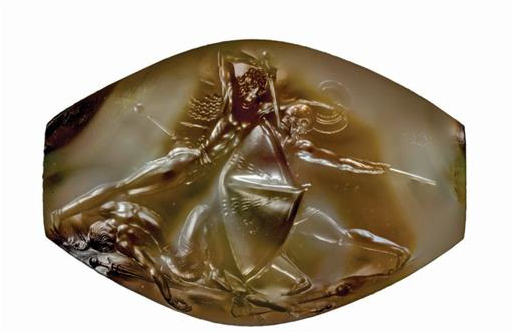
(The Pylos Combat Agate, found in the Griffin Warrior’s grave, is an extraordinarily fine seal stone measuring only 1.4inches wide. It depicts the final moments of a battle among warriors.)
❖❖❖❖❖❖❖❖❖❖❖❖❖❖❖❖❖❖❖❖❖❖❖❖❖❖❖❖❖❖❖❖❖❖❖❖❖❖❖❖❖❖❖❖❖❖❖ With many thanks to this month’s contributors: David Willoughby, Sylvia Javes, Jim Nelhams, Jo Nelhams, Bill Bass ❖❖❖❖❖❖❖❖❖❖❖❖❖❖❖❖❖❖❖❖❖❖❖❖❖❖❖❖❖❖❖❖❖❖❖❖❖❖❖❖❖❖❖❖❖❖❖
Please note that until further notice all lectures will be held online via Zoom due to coronavirus. We will be sending out an invitation email with instructions about how to join on the day of each talk. Keep an eye open for them!
Tuesday 10th November 2020, 8pm: London’s Roman and Medieval Wall. Lecture by Dr Jane Sidell.
December– As yet, no decision has been made concerning a Christmas gathering.
Tuesday 12th January 2021Surprises from the Soil: Archaeological Discoveries at 17th-Century Jamestown, Virginia. Talk by Dr Bly Straube – Senior Curator at Jamestown Settlement, Virginia USA.
HADAS using “new” technology
The pandemic has seen a great increase
in the use of technology, not just in business. Prime among these is the use of
Zoom (or equivalent) for online meetings. Families split by lockdown are able
to see each other and talk, but there are so many other uses. Zoom can be run
on laptops, desktops, Ipads or even phones.
The use of Zoom means that we are not
restricted by geography in choosing our lecturers. Our January lecture will be
coming from the other side of the Atlantic. Suggestions for other lecturers
outside our normal area would be welcomed by Steve Brunning (membership@hadas.org.uk).
The Lecture by Les Capon on 13th October was entitled Medieval Houses to Community Archaeology: Excavations at Eastcote House Gardens, 2012-17. This was our first lecture using the Zoom facility (thanks to David Willoughby for organising this) and there were 29 households “tuning in” to hear about the excavations at Eastcote House Gardens. An important aspect of the project was the successful involvement of local volunteers.
1
Afterwards, there was time for a few questions and for those who were not able to listen live, the lecture is available via the HADAS website for members only on the HADAS YouTube channel using this link: https://youtu.be/NQDsWrp8KNk Note that lectures can only be recorded with the express permission of the lecturer.
A write-up of the lecture will appear in the December newsletter.
Before the start, there was an opportunity for some online socialising which was very welcome.
On 22nd September, David Willoughby organised a trial run with Zoom for members in the form of a quiz. There were rounds on history, London, archaeology and general knowledge. An enjoyable event and a good test of the technology and seeing others of course including those who have moved away from London.
Are you missing out? We can only send you the information needed to connect to our Zoom events if we have your email address. If you are receiving your newsletter by email, then we already have it. If your newsletter comes by post, we may still have your email address, but maybe not. If you are in doubt, please send your email address to membership@hadas.org.uk, preferably by email so that we can be certain to record the correct punctuation. Adding your email address to our system means that any circulars we issue should reach you promptly.
Malcolm Stokes, 1933-2020 Eric Morgan
Malcolm Stokes sadly died in July after a long stay in hospital. He was a long-standing member of HADAS. He had a lifelong interest in history and archaeology. In fact he met his future wife, Isobel on an archaeological dig in Canterbury in 1965.
He was a long-time committee member of the Hornsey Historical Society and had an interest in the Bishop of London’s connection with Highgate and wrote on the Bishop’s Deer Park and Hunting Lodge. He had given HADAS a lecture on this in recent years.
He had an abiding interest in boundaries and wrote A walk along the ancient boundaries of Kenwood in 1995 of which HADAS had many copies for sale. He also led a walk for HADAS around Kenwood pointing out all the boundary stones to us, some years ago. Malcolm died in the Whittington Hospital on 19th July 2020 and will be very much missed.
HADAS Basement Room HQ Bill Bass
We have been meeting on Sunday mornings again at Avenue House. Unfortunately we’ve had to limit them a bit due to the Covid situation. We have been mostly re-organising the archive files, photos/slides and HADAS business papers and accommodating older material once held by Chris Newbury including files from Bridget Grafton-Green, Ted Sammes and other stalwarts of the society.
We have also tidied-up the tool room to make it more accessible and are continuing re-order the book collection. There are a number of finds that need cataloguing and storage.
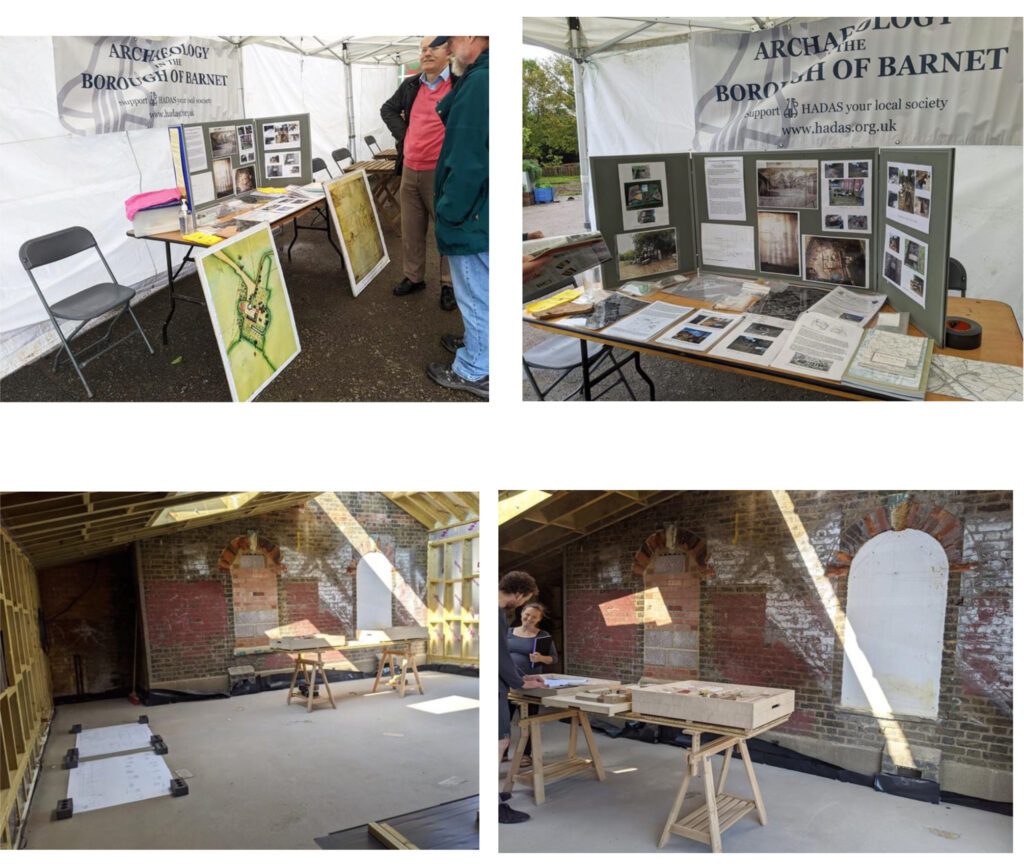
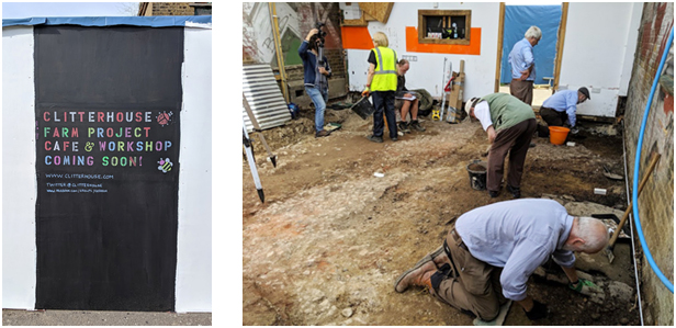
The team have attended two events at Clitterhouse Farm, Cricklewood with our display of HADAS excavations held there since 2015 up to our last dig in 2019.
2
They continue with building their new cafe area (under where HADAS dug in 2019) which should be finished soon – two photographs show this area. Photos by Melvyn Dresner
Air Raid Shelters and Medieval Farms Roger Chapman
Every now and again HADAS receives a request to look at a feature, a structure or building to see what we think. The recent mediaeval building in Barnet High Street which Bill Bass wrote about in the October newsletter is one example.
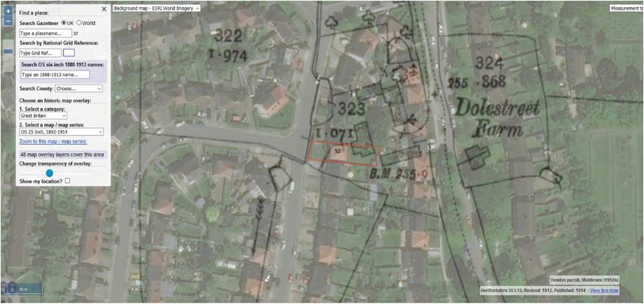
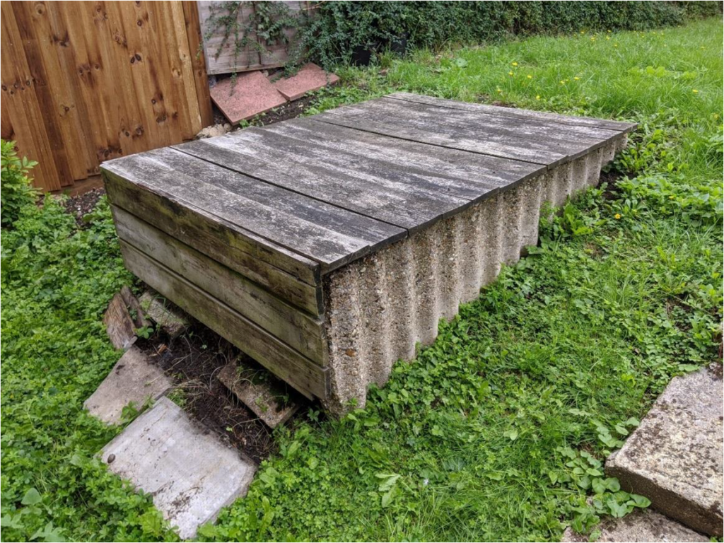
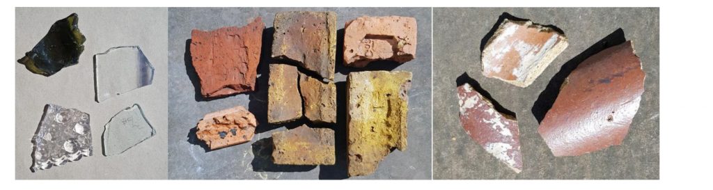
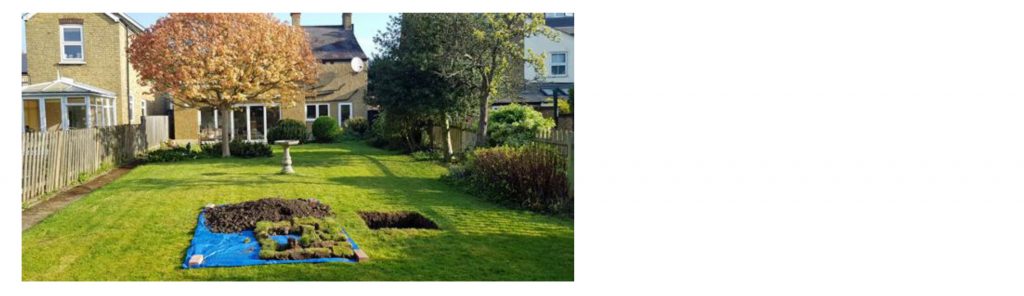
In August 2020 HADAS received an email from a resident in Mill Hill about a structure in her garden and whether we would like to examine it. The resident said that:
“The house had a deep crater in the front garden when we moved in (15 years ago) and a lot of debris (glass, roof tiles etc) in the back-garden soil. There was a structure covered over with wooden planks in the back garden which we were curious about, it appears to be sealed/covered. We have been told that it’s a WWII bunker and that probably a bomb fell near the house during the war, accounting for the crater and debris.”
This tempted me as, along with a friend who also has a keen interest in Military History, I have been working on an idea to set up a Facebook page called ‘Barnet at War’ to identify
3
military objects, structures, memorials etc. that still exist in Barnet and make sure that they are recorded before, as so often happens, they are lost to development.
Before going I did some research and found that this garden could be have greater interest than just a Second World War air raid shelter. Using the 1912 historic OS map from the National library of Scotland and laying it over a modern satellite image it looks like the garden could contain structures from Dole Street Farm. This farm appears on Whishaw’s 1812 map of Hendon and features on the 1754 John Roque map. The surrounding roads of Wise Lane and Dole Street can be traced back to this time and may well be mediaeval in origin.
The World War two bomb map of Hendon shows a bomb strike near the property adding some credence to the resident’s story about the crater.
My friend and I arrived early so we decided to visit Mill Hill Cemetery, just over the road. Here we found The Netherlands Field of Honour, established in 1965. The plot contains the graves of more than 250 servicemen of the Netherlands, many of them having been brought to the cemetery from other United Kingdom burials grounds. Most of the graves are those of Merchant seamen. We didn’t know about this Field of Honour so that gives us another ‘Barnet at War’ story. https://www.cwgc.org/visit-us/find-cemeteries-memorials/cemetery-details/2094634/mill-hill-cemetery/
The resident, who is extremely keen on local history gave us a warm welcome and showed us around her back garden and it most certainly does look like there is a shelter of some kind from the Second World War but as yet we have been unable to find reference to it in the Barnet archive or on aerial photos.
4
The rest of the garden is flat and the terrain suggests that there could be structures underneath towards the rear of the garden.
With the resident’s consent and COVID willing, we hope that HADAS will be able to undertake a quick test pit dig next year to ascertain firstly: what the concrete structure shown in the photograph above is and secondly to see if there is any evidence of farm buildings in the garden.
In the meantime, if you know of any military structures/memorials lurking away in hidden corners of the Borough do drop me an email and let me know. Roger.chapman99@btinternet.com
History beneath us – Parch marks at Cherry Tree Wood, East FinchleyRoger Chapman
5
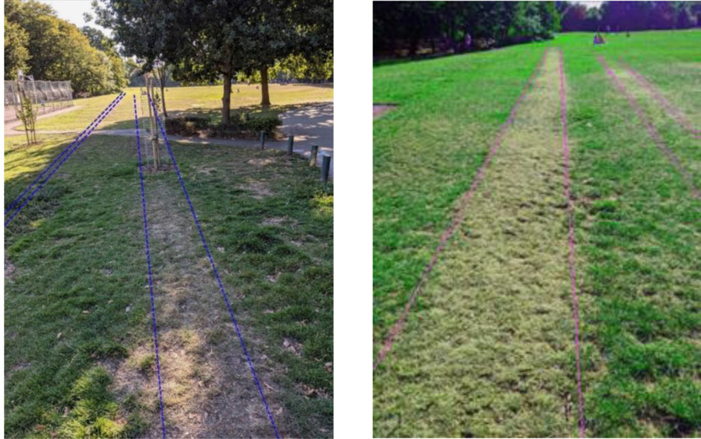
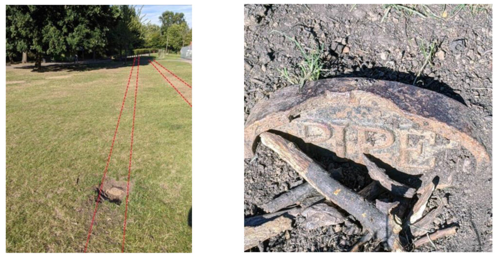
The dry weather in August 2020 began to reveal a lot of activity at Cherry Tree Wood in East Finchley. A range of parch marks started to appear and began to tell the story about what lies beneath the surface of this small Barnet park and remnant ancient woodland.
Parch marks are mostly caused by buried structures such as walls, pipes and drains or paved areas. The structure inhibits the grass roots in the overlying topsoil and the result is an area of weak growth that can show as a white or brown mark reflecting the shape of the structure underneath.
The photographs above show two parallel lines which I think are underground water pipes – the exposed metal sign part way across the field which reads “pipe” is a good giveaway.
A few years ago, another sign was exposed reading MWB or Metropolitan Water Board. Between 1906-08 the Metropolitan Water Board built two covered reservoirs at Fortis Green. They were supplied from the Staines reservoirs (fed from the River Thames) some 17miles away and conveyed in a 42-inch diameter pipe which crosses Cherry Tree Wood as you can see in the photos. I believe there was a second pipe constructed in the 1920’s, as indicated by the parallel parch marks, but I am still researching to confirm this.
In addition to these marks a regular diagonal pattern of parch marks also appeared, coinciding with large cracks in the earth, some as wide as 9 inches, which are on the line of field drains laid to drain the central grassed area of the park when it was in use as a football pitch. Cherry Tree Wood also has an interesting northern boundary being part of the Bishop of London’s hunting park boundary dating from at least the fourteenth century.
My introduction to re-enactmentBob Michel
Historical re-enacting – what’s the point? On August bank holiday back in 1991 my wife-to-be and I arrived at Boscobel House near Worcester to see Sir Marmaduke Rawdon’s Regiment of Foote show us. Rawdon’s, for short, is part of the King’s Army of the English Civil War Society. In spite of the following account of my afternoon I must have been convinced, as I remain an active member to this day. Why? Read on…………………
6
It had all started so promisingly. Boscobel House was easy to find, the sun was shining and the regiment’s Quartermaster seemed pleasant enough. Carried away by this, I allowed our tentative first visit to watch Rawdon’s do what they do best to become something altogether different.
My comfortable holiday-making clothes were soon exchanged for last-in-the-kitbag pikeman’s togs. Not being a stock size I was used to clothes fitting where they touched, but this was something else. The metal helmet would have been even more uncomfortable had it not been a couple of sizes too big. However in the calm of the campsite this mismatch with my head didn’t seem terribly important…………
The Quartermaster asked if I’d played rugby. On receiving an affirmative, he explained that being a pikeman was similar to being in a maul; that is, trying to gain ground at the opposition’s expense. Only here instead of carrying a ball you lugged a 16 foot pike (or spear-like thing) around. I can’t now recall what I thought about that at the time, but I did receive a crash-course in how to manoeuvre said pike. I was now a fit-for-purpose pikeman!
Well almost. My basic training was completed under the tutelage of the Officer i/c the pike division in the re-enactors’ beer tent. What could possibly go wrong?
Well the only thing I can clearly remember about my ‘finishing school’ is that on exiting the beer tent, I unwisely took a short-cut to the toilet area where the chemi-karzis were all lined up. Sadly my hurdling technique left something to be desired and I left a few threads of posterior-area breeches on a barbed wire fence. My first war wound and I hadn’t even left the campsite.
And so to battle. It’s all a bit of a blur now – as then – but I can remember the spiky stubble in the field; the smoke and the shouting; not being able to pick our flag out from all the others being frantically waved around in the identity parade; and an all-encompassing feeling of not knowing what the b****y hell I was doing, or why. In all my battles since it’s never got more authentic than that.
To coin another phrase, it was all over before I was ready. At the final whistle I was very hot, very thirsty and very tired. Moreover I didn’t really know what had happened, let alone who’d won, as my helmet had slipped over my eyes at regular intervals. Back at the campsite I was looking forward to collapsing, which I did, spurning the lunatic-sounding invitation to participate in some energy sapping “RAWDON’S GAMES!”. This proved to be a wise decision as said games involved a lot of running around.
What on earth had I done? But it was already too late to escape from the mad house. As they say the rest, like the real battle of Worcester, is history.
7
Roman Finds Group Sue Willetts
I was able to attend part of a zoom conference on New Research on Finds from Roman Scotland and the North, on 16-17th October.
There were over 270 people attending this free event. The last session on Saturday morning was on Vindolanda and included talks on gaming boards, spindle whorls and leather remains including what seems to be a toy mouse.
I was very impressed and have joined the group which is £12.00 a year. https://www.romanfindsgroup.org.uk/membership
❖❖❖❖❖❖❖❖❖❖❖❖❖❖❖❖❖❖❖❖❖❖❖❖❖❖❖❖❖❖❖❖❖❖❖❖❖❖❖❖
With many thanks to this month’s contributors: Bill Bass, Roger Chapman, Eric Morgan, Bob Michel, Sue Willetts
Tuesday 13th October 2020, 8pm: From Medieval Houses to Community Archaeology: Excavations at Eastcote House Gardens, 2012-17. Lecture by Les Capon.
Tuesday 10th November 2020, 8pm: London’s Roman and Medieval Wall. Lecture by Dr Jane Sidell.
As yet, no decision has been made concerning a Christmas gathering.
Please note that until further notice all lectures will be held online via Zoom due to coronavirus. We will be sending out an invitation email with instructions about how to join on the day of each talk. Keep an eye open for them!
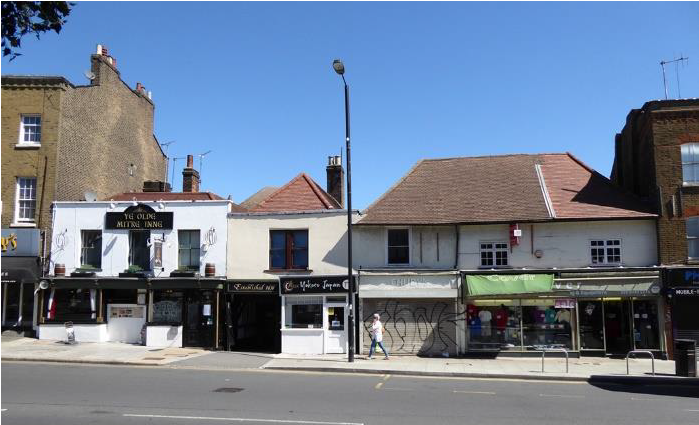
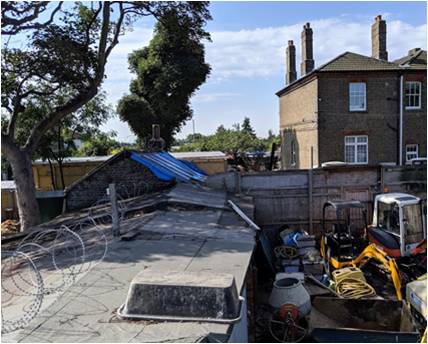
54a Barnet High Street – a timber framed buildingBill Bass
A site visit was made to 54a Barnet High St (currently named ‘Chudy’s) in August by interested parties including HADAS, Barnet Museum and others. We were guided by Architectural consultant, Sherry Bates and by the owner who is asking for planning permission and listed building consent to covert the 1st floor to a dwelling with the ground floor kept for commercial premises.
‘Chudy’s’ stands immediately to the right of the lamp post
A very full Heritage Statement has been produced on this Grade II listed structure. 54a is part of a group of listed buildings here which includes The Mitre Inn complex, these buildings were at one point 3 separate inns but eventually grouped together as The Mitre in 1633 with evidence of interconnecting doors and other features. HADAS dug at the rear of The Mitre in 1990 finding medieval and later pottery, these finds have recently been reviewed as part of the HADAS evening class system.
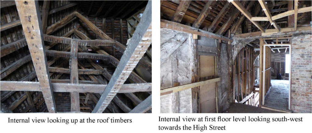
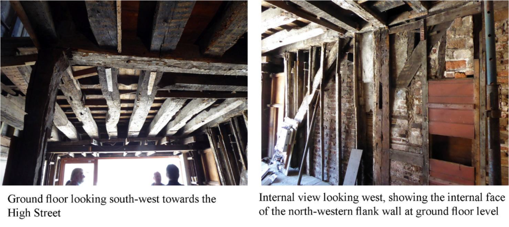
1
The modern wall coverings had been stripped away which had revealed much more of the timber-framing than had been expected, it has been found to be largely intact. The timbers (mostly oak) were laser-scanned to produce accurate drawings. Dating of the structure is open to debate at the moment but it’s thought to be quite a lot earlier than the 17th century. There are possible moves afoot to get a tighter date through stylistic and dendrochronological (tree-ring dating) methods especially as many of the timbers are accessible at present.
The idea is to keep as much of the original timbers as possible and sympathetically restore other infilling fabric and so forth. There are also several later additions – roller shutter door, steel beams, staircase etc which will also be kept because to remove them would cause to much disruption and destabilisation.
2
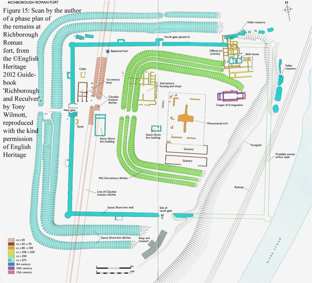
Aspects of Roman Richborough Robin Densem
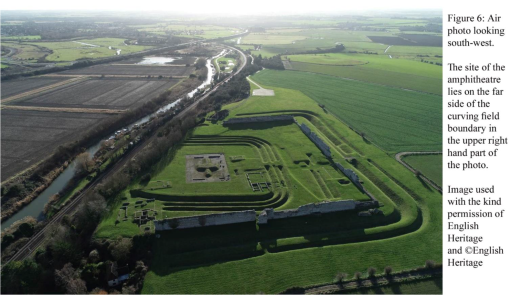
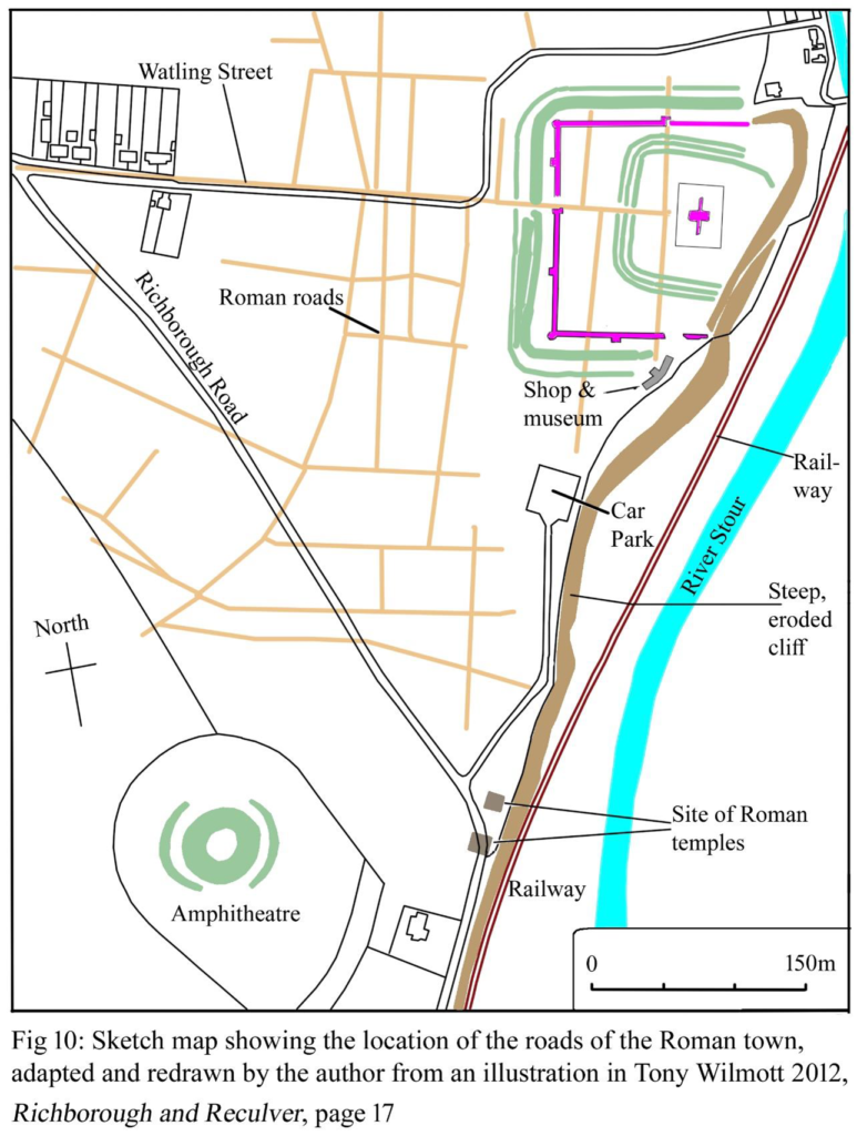
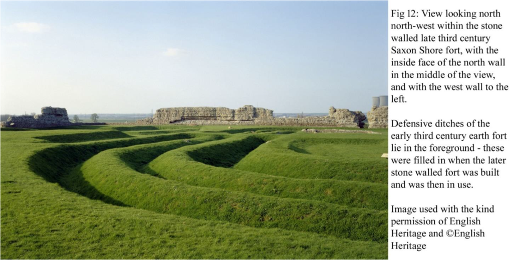
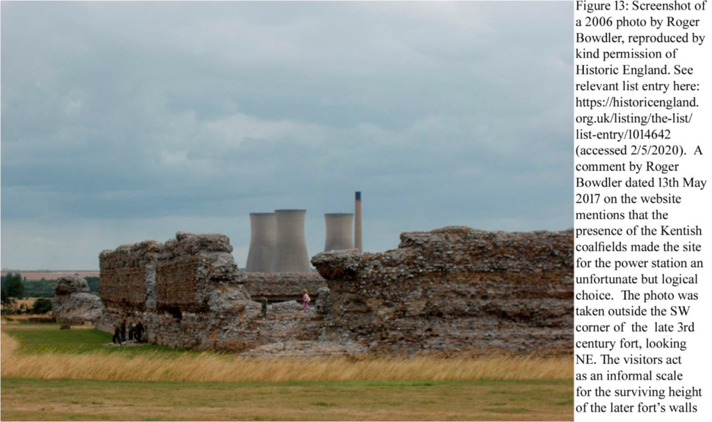
The most obvious remains are of the late third century walls of the Saxon Shore fort which still stand in places to a height of 8m. Saxon Shore forts were heavily defended later Roman military installations located exclusively in south east England. They were all constructed during the third century AD, probably between c.AD 225 and AD 285. They were built to provide protection against the sea-borne Saxon raiders who began to threaten the coast towards the end of the second century AD, and all Saxon Shore forts are situated on or very close to river estuaries or on the coast, between the Wash and the Isle of Wight. Saxon Shore forts are also found on the coasts of France and Belgium. The most distinctive feature of Saxon Shore forts is their defences which comprised massive stone walls, normally backed by an inner earth mound, and wholly or partially surrounded by one or two ditches (https://historicengland.org.uk/listing/the-list/list-entry/1014642).
3
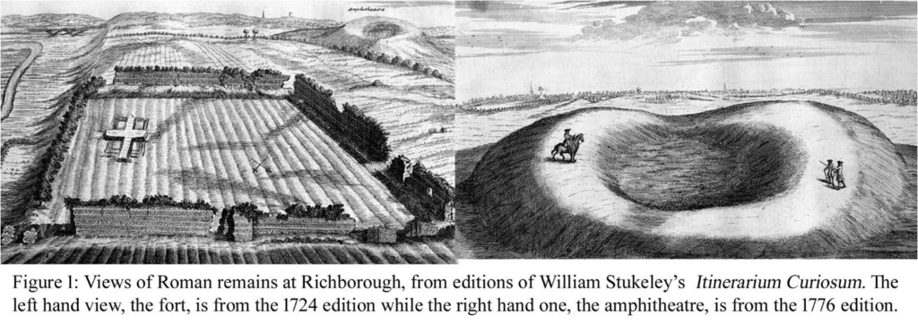
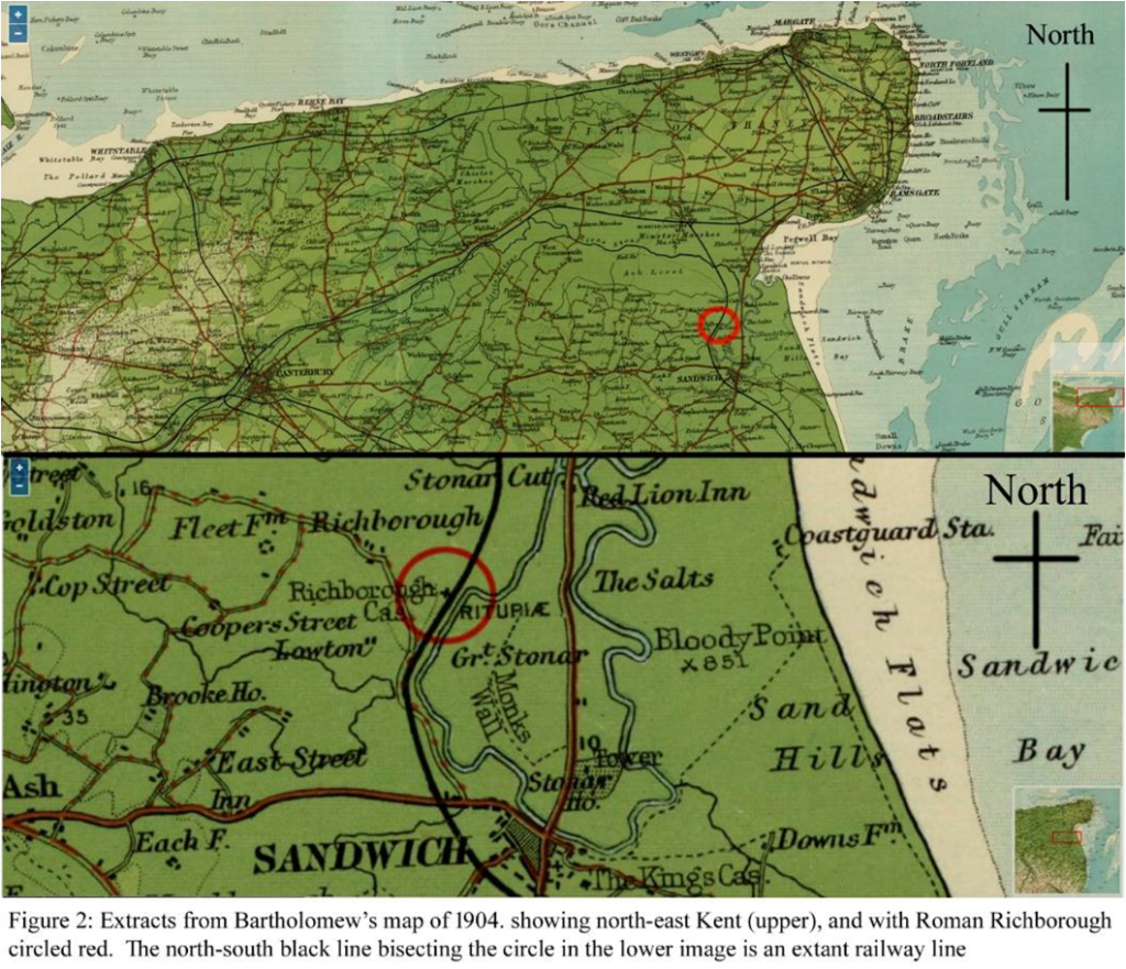
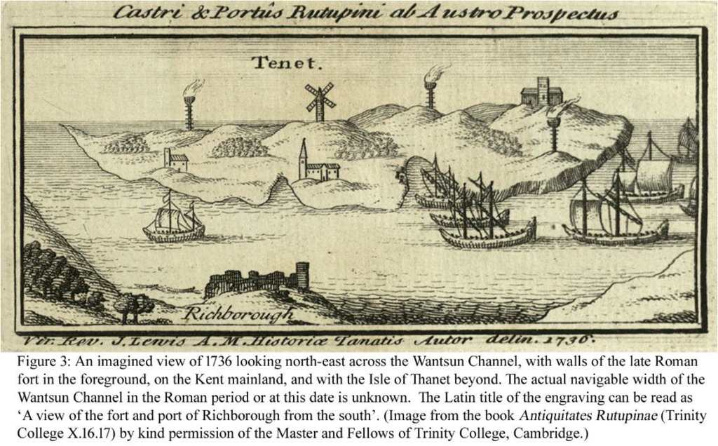
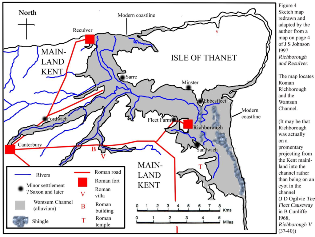
The site at Richborough now lies about 2.5km inland from the coast, but in Roman times in was on the western bank of a natural navigable channel. Some plans of the ancient topography, including fig 3 here, show the site as lying on an eyot in the channel.
The navigable width of the Wantsum Channel in Roman times is unknown but it is shown as being wide in 1736.
4
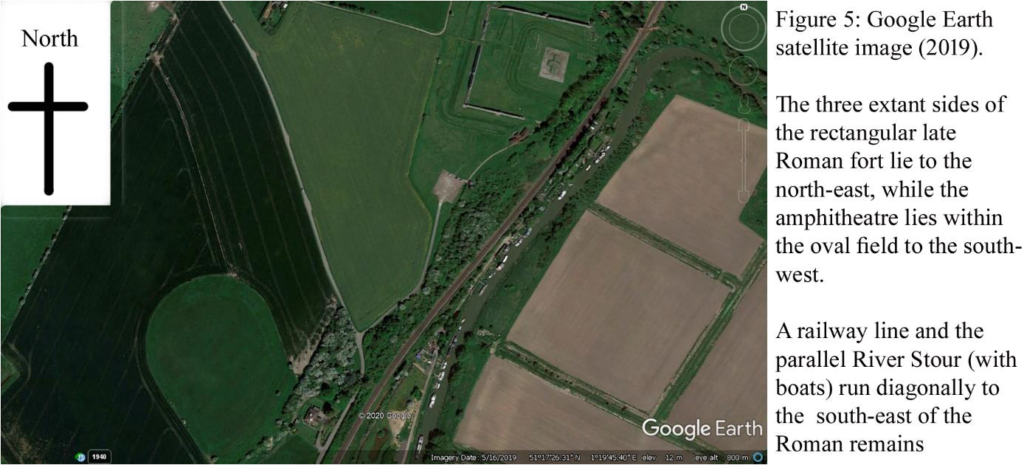
The Richborough site includes an area of c.40ha containing a variety of archaeological components dating from the Iron Age, Roman and medieval periods.
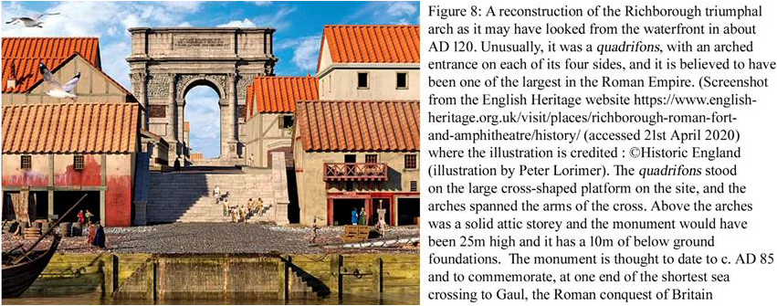
The Roman site is multi-phased and includes evidence for a mid 1st century AD Roman military style double ditch with an opening/gatewey that is thought to be connected to the Roman invasion of Britain under the emperor Claudius in AD 43. The ditches extend for a length of 700m but their northern and southern ends have been destroyed by erosion and their original, longer, length is unknown. It seems unlikely that the enclosed area could have been large enough for all the Roman invasion army in AD 43, and a defence to defend the natural harbour and a beach/landing place in the Wantsum Channel seems more likely, though still involved with the early stages of the Roman invasion. As the Historic England 2012 guidebook Richborough and Reculver by Tony Wilmott mentions, there have been more than one landing place for the 40,000 strong invasion force in AD 43.
5
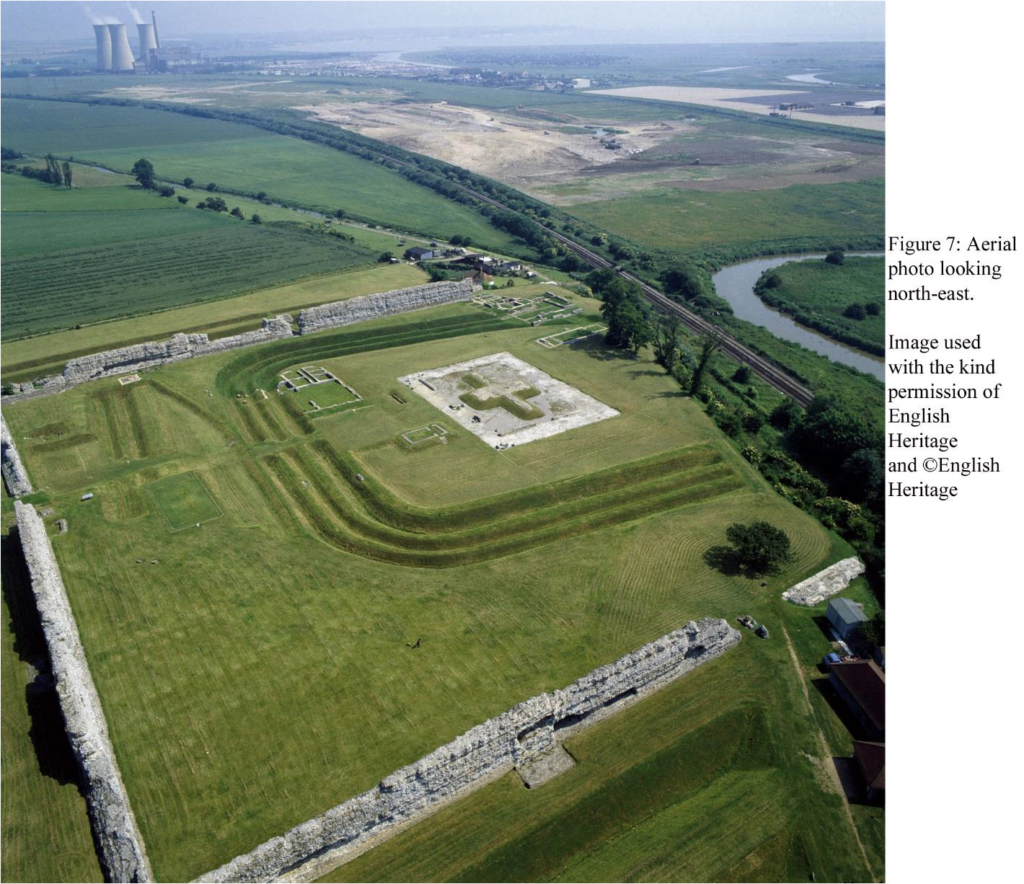
The large masonry rectangle is the base of a 25m high monumental arch, shown to have 10m deep foundations. Much knowledge of the Roman site comes from archaeological excavations carried out the Society of Antiquaries of London between 1922 and 1938 and published in four research reports of the Society by Bushe-Fox, along with a fifth by Barry Cunliffe. All five volumes are available online from Archaeology Data Service (archaeologydataservice.ac.uk).
The invasion camp was used for a period of less than ten years before being levelled to make way for the construction of a military and naval supply base. This helped store and distribute the supplies needed by the Roman forces during their rapid conquest of southern Britain. Part excavation during the 19th and early 20th centuries revealed that the base extended westwards beyond the ditches of the earlier invasion camp and was constructed on a grid pattern. The base survives in buried form and includes traces of timber buildings alongside metalled roads. (https://historicengland.org.uk/listing/the-list/list-entry/1014642 accessed 17th May 2020).
6
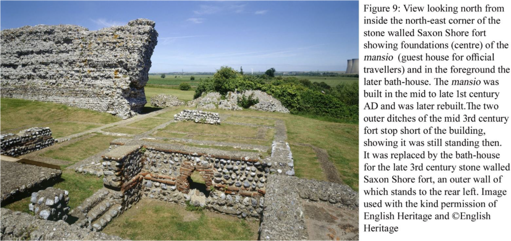
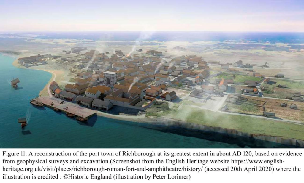
Recent archaeological work by English Heritage and then by Historic England has shown that the civilian settlement that developed around the early Roman 1st century invasion period base extended over some 20ha and included a grid of roads, shops, warehouses and a mansio, or rest house for travellers on the Roman imperial courier service.
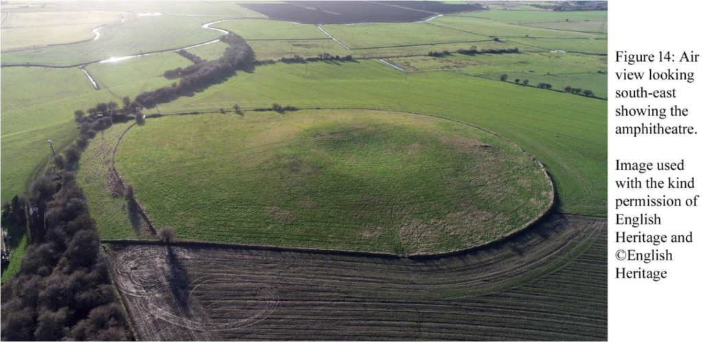
It is hoped that archaeological investigations will be carried out to learn more about the amphitheatre.
There is so much Roman archaeology to see at Richborough that it is a bit of a feast, but rather confusing, as laid out for display within walls of the late third century Saxon Shore fort are the lengths of the mid 1st century invasion period Roman military ditches, a 1st century shop, the base of the quadrifons, early 3rd century defensive ditches dug to defend the monumental arch when it became a look-out station within the earth fort, and then the earth fort ditches were backfilled in the later third century, the arch was demolished and the walls of the Saxon Shore fort were built. A fourth century Christian font is displayed,
7
reflecting the adoption of Christianity as the official religion of the Roman empire from the early fourth century AD. It is thought that there were some ten Saxon Shore forts in Britain, all built in the later third century AD. The term ‘Saxon Shore’ is known from only one contemporary source, the Notitia Dignitatum.
The forts on the Saxon Shore, popularly associated with defence against Saxon raids, lie on the coast from the Wash to Portsmouth Harbour. One of the forts, on the coast at Walton in Suffolk, has been washed away by the sea The other nine forts each have at least some remains standing (https://historicengland.org.uk/images-books/publications/iha-saxon-shore-forts/heag232-saxon-shore-forts/ ) and most of these can be visited but best to check access, times, and admission prices before travelling. Lympne is on private land.
Harvey Sheldon’s 1995 article London and the Saxon shore was published in volume 46 of the Transactions of the London and Middlesex Archaeological Society (pages 59-68)
8
(http://www.lamas.org.uk/transactions-archive/Vol%2046.pdf ) . He wrote (p. 66) The forts are situated on or close to the coast, often at the confluence of major rivers coming from the interior and could have functioned as guarded warehouses where supplies arriving from the interior could be stored before being transported, perhaps in convoy, across the Channel and the North Sea to the Continent.
A good clue to this, Harvey mentioned to me recently, is the remark of the emperor Julian of convoys from Britain supplying his Roman troops campaigning across the Rhine in the later 4th century AD.
9
All in all Richborough is a wonderful site to visit. Years ago I used to lead adult education classes on weekend trips to Roman Kent from London. We used to stop off at Lullingstone Roman Villa, then go on to a ruined Roman mausoleum in a field at Stone-by-Faversham, then on to the Saxon Shore fort at Reculver where a pub was also visited. Richborough in the afternoon and then we stayed overnight in Canterbury. Sunday started at the Roman lighthouse in Dover Castle, then the wonderful Roman Painted House also in Dover, and if time we visited Dover Museum which then featured model figures of the invasion army with Claudius astride an elephant! The final stop was the wonderfully beautiful site of the Roman Saxon shore fort at Lympne. I have a handful of successive editions of guide books to Richborough and Reculver, representing visits over perhaps 20 years. The current (2012) Historic England version by Tony Wilmott titled Richborough and Reculver is an absolute cracker, it is marvelous! I don’t think there is public access to the amphitheatre at Richborough at present but it can be glimpsed, I think, from a footpath.
10
11
Richborough Roman fort is in the care of English Heritage and there is an admission charge to visit the site if it is open, so best to check. People may need to book their visit. Acknowledgements:: I am grateful for help from Joe Abrams , Duncan Butt, English Heritage, Historic England, Jim Nelhams, Sandy Paul, Harvey Sheldon, and Tony Wilmott. All errors are mine.
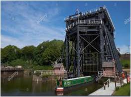
A Footnote to HADAS taking to the Waters (Newsletter 594)Robert Michel
Further to Jim Nelhams’ piece ‘HADAS taking the Waters’ (Newsletter 594), Andy Simpson and other rail enthusiasts will be delighted to hear that the Berney Arms windmill near Great Yarmouth is not only accessible by boat. Norwich to Yarmouth trains via Reedham will stop at the mighty Berney Arms Halt if you give the Conductor sufficient warning. The mill is only a short walk across the marshes from the halt’s modest platform, but take Wellington boots if it’s been raining. This all pre-supposes the rail company hasn’t discontinued this service – in the best journalistic tradition I haven’t checked before taking to the keyboard!
Number 594 September 2020 Edited by Stephen Brunning
HADAS DIARY – LECTURE AND EVENTS PROGRAMME 2020
Tuesday 13th
October 2020: From Medieval Houses to
Community Archaeology: Excavations at Eastcote House Gardens, 2012-17. Lecture
by Les Capon.
Tuesday10th November 2020: To the confirmed.
As yet, no decision has been
made concerning a Christmas gathering.
Please note that until further notice all lectures will be held online via Zoom due to coronavirus. We will be sending out an invitation email with instructions about how to join on the day of each talk. Keep an eye open for them!
Membership Renewals – a reminder. Stephen Brunning.
Many thanks to those who have already paid their subscription. If you intend to renew this year and have not yet done so, I would be grateful to receive payment by 15th October 2020 at the following rates: £15 (Full), £5 (each additional member at the same address), and £6 (student). My address is on the last page of this newsletter.
It is not necessary to return the renewal form enclosed with the March newsletter. A piece of paper with your name, postal address, telephone number and email address (if applicable) will suffice. I will then be able check the details we hold are still correct. If you have not already done so, it would also be helpful if you could indicate your willingness to receive the newsletter by email. This helps to keep our costs to a minimum. Thank you.
It is with great sadness that we
learn that Annette Bruce died on 1st August at Charing Cross
Hospital following a stroke.
Annette joined Hadas in 2016 and
regularly attended our lectures. She also joined and thoroughly enjoyed our
2019 trip to South Wales.
Annette had a remarkable zest for
life and learning. She loved being able to attend exhibitions and concerts and
visited the Troy exhibition at the British Museum shortly before lockdown. She
challenged herself with Japanese and Welsh classes and performing in piano
concerts with fellow students, and she enjoyed travelling the world on historic
and cultural lecture tours.
Outings in the newsletter Jim Nelhams
Jo and I have a big gap in our diary for
September where normally we would have a 5-day long trip with HADAS members. We
have always aimed to visit unusual places and places that you would not visit
on your own. While we did visit a number of likely places before the lockdown,
our list was not complete so more work was needed, and some we had already
checked have not yet re-opened or have problems with larger groups and social
distancing.
The first trip we organised with help from Don
Cooper before he became unwell, was in 2009 to Hereford. In earlier times, each
trip was written up by a small number of members, usually just four. We asked
for volunteers on each trip to cover just one location and serialised the
articles in our newsletters over the winter months. This year, we will not be
so fortunate and will leave gaps.
Counting back, the 11 outings from Hereford
onwards have provided 223 articles from 44 different authors. It has given
people the chance to note something that has interested them, and the variety
of styles has added to the interest. Our thanks to them all.
Church end farm 1961-66 – additional details on surviving ceramic building material, pottery and clay pipe Andy Simpson
I was interested to
read the note on Dr Brian Robertson in the August newsletter and the
involvement of himself and his late brother Ian in the Church End Farm
excavations in the 1960s. This has prompted me to forward this review of
additional Church End Farm material located in the HADAS archives over the past
five years or so, since the original publication of ‘The Last Hendon Farm’
Following publication of the original Church End Farm book, ‘The Last Hendon Farm – The Archaeology and History of Church End Farm’ by the HADAS Finds Group and edited by Jacqui Pearce, when clearing out the former ‘garage store’ an additional four boxes of previously unrecorded ceramic building material (CBM) were found amongst the stored HADAS artefacts. These are additional to the two boxes that were initially available for study when the book was originally researched. These four boxes contained in total two fragments of possible chimney pot, one small piece of Roman tile, one substantial piece of post-medieval pottery, three complete lengths of field drain, two pantiles, two small pieces of grey roofing
2
slate, a short single length of one-inch diameter wooden wattle, three peg tiles, three curved roofing tiles, two nibbed tiles, and nine ‘house’ bricks and seven paving bricks, the latter with an average width of four inches.
In February/March 2016 the opportunity was
taken to sort and fully record them and attempt to match them with relevant
sections of the above published account. Not all could be matched with the
published account, but those that could be identified with some confidence are
listed below.
They represent both Site 1 (The Farmhouse, dug
in 1961, 1962, 1964 and 1966) and Site 2 (The Paddock, south–west of site 1 and
dug in 1964 and 1966; it happily still survives as an area of open ground used
by Middlesex University), often with quite detailed card tag labels attached.
One
additional pottery item was identified; a large English brown
salt-glazed Stoneware pot or jar lid, slightly chipped on one side, with a
diameter of 7.5 inches/180 mm, weighing 1263g, with three finger holes in top
to aid grip. Dated 1700 – 1900, It is marked CEF64, box code AA.
Two
further clay pipes have also been found in material left by the late
Ted Sammes.
One is a plain, reconstructed bowl of type AO25, dated 1700-1770, with bottered rim. It has no maker’s mark but does retain 148mm of surviving stem and has splashes of yellow glaze on the right-hand side bowl and stem. It is marked ‘CEF N’. The HADAS publication ‘The Last Hendon Farm’ records in the coins and tokens section on page 71 that context N was dated 1680-1700 – so just about matches – and also contained a Charles 1 farthing.
And over 50 years on, we are STILL finding
items from the Church End Farmexcavations recorded some years ago in
the HADAS publication ‘The Last Hendon Farm’
From further material recorded in 2019, Sammes
Clay Pipes List CFM 30 is another one of these – an unmarked bowl of type AO25,
1700 – 1770,finely burnished with a cut top and
marked with trench/context details CEF64 K2 30, suggesting it is from
the main farmhouse site, on the west side of the west wall area.
The Last Hendon Farm, p.71, gives a date of
1640-1660 for the context, so perhaps this is a residual item.
A major find when studying the additional CBM was
a small corner fragment of Roman
hypocaust combed Box-Flue tile, weight 65 grammes and with sides 0.5
inches/13mm thick, complete with surface combing. It was with the marked box
code CE, and goes with the very limited Roman pottery finds from the site –
single sherds of the ubiquitous in Hendon Alice Holt/Farnham Ware, plus
sand-coloured coarseware and Gaulish amphora (Op cit p.42)
There
are numerous items from Site 1.
From the first 18 inches depth of rubble
Trench C in the area of a brick drain and step, there is for some reason a
single piece of grey slate retained, labelled with the dates 24/6-1/7.
From Trench H, which lay across the
foundations of the demolished south wall of the farmhouse, we have a single
brick, 5 x 2 x 1.25 inches, labelled 15 July 1962, 30 inches down (23 inches
below burnt layer); 35 inches north from top of well.
3
Brick and tile drains have been a feature
of many sites excavated by HADAS, from Church End Farm to Burroughs Gardens to
Clitterhouse Farm. The CEF book illustrates a fine example – Fig. 23, on page
32, from Site 1 Trench 18. Deeply laid, it ran north-south and was constructed
of two courses of brick on a tile base; another similar drain underlay the
south extension wall. Parts of one of these, possibly the former were retained
and were reconstructed in 2016, helped by careful numbering of the bricks by
the original excavators. There are two peg tiles, each measuring 10.25 x 5.75 x
0.5 inches, with heavily mortared inner face and upper surface mortared at each
end where the bricks were laid on top of the bricks, there are three identical
9 x 4 inch bricks and weighing some 2kg.
In 1964, trench 1 was excavated along the line of the former west wall
of the farmhouse. From it, we have a single brick, 6 x 1.75 x 2.5 inches,
marked 28 July, mortared on four sides.
Another 1964 find is a 14.5 x 7.5 x 0.75 inch nibbed/flanged tile
labelled ‘from small boiler house of the old greenhouse 30/8/64’, with
interlocking flange and notably sooted interior and weathered external/upper face.
Two bricks of similar size bundled together are labelled ‘from
Herringbone (floor) over Trench 12’. A third, smaller brick measuring 4.5 x 4 x
2.75 inches from Trench 12, layer 5 is dated 29 /8/64, and is marked with the
box code KS.
There is at least one fragment of chimney pot, heavily sooted on its
curved inner face, diameter 15 inches/360 mm, with a raised pecked ridge and
leaves decoration.
From site 2 – The
Paddock
– we have two lengths of typical coarse red fabric field drain of probable
nineteenth century date, excavated in 1966, from squares 6B and 6C. This
tallies with the account on page 7 of the CEF book mentioning drains seemingly
from the same system found in these two trenches. Both recovered lengths are 12
inches long with a two-inch bore; one has a moulding seam and flattened side,
the other, strangely, bears evidence of sooting on one side.
A third length of field drain is also 12 inches long with a two-inch
bore, with the box code CEF64 AO.
The Government has just
published a White Paper ‘Planning for the Future’ which proposes a complete
reform of the planning regime. Very briefly, it would divide the whole of
England into ‘Growth’ ‘Renewal’ and ‘Protected’ areas; in Growth areas there
would be automatic outline planning permission for the principle of
development; in Renewal areas there would be a general presumption in favour of
development; and in Protected areas (including Green Belt and conservation
areas) there would be the same requirements for planning permission as at
present.
These proposals have only
just appeared and are out for consultation until the end of October; they are
controversial and there is a lot of significant detail in them. The main
concern for archaeologists is whether they will weaken the power to impose
conditions requiring archaeological investigation in advance of development.
For Archaeological Priority Areas are not of themselves protected areas (though
in towns and cities they may often be protected as conservation areas).
I expect this matter, and
the related implications for the Barnet Local Plan (on which we are awaiting
the Council’s next move) to take up much of my time in the autumn.
4
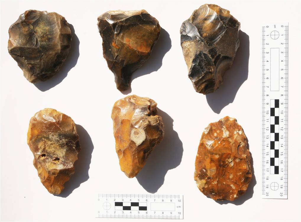
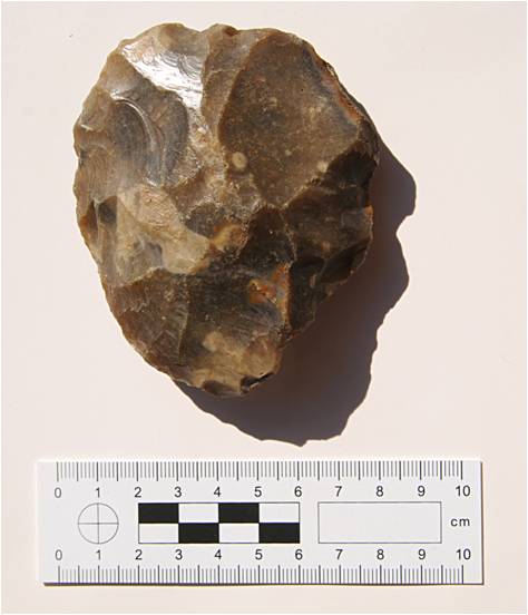
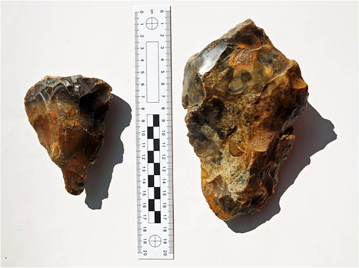
HADAS Hand-axes Bill Bass
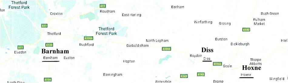
Through the good offices of Chris Newbury and his late mum Dorothy, we have received several boxes of assorted finds, files and maps etc from members past and present. Amongst these is a wonderful collection of 10 hand-axes. While there’s not really a HADAS connection (?), they were given to us at some point in the past. The newspapers they are wrapped in date to 1990 and the plastic bag they are in relates to ‘SHUTLERS’ in Temple Fortune Lane (Home and Garden goods). A tag tied to the bag says “Flint axes given me by David St George. Exact provenance unknown, but found in the area of Diss.”
The hand-axes appear to include a mixture of ovate,
triangular and pointed shapes, all unmarked. Diss in Norfolk is nearby to Hoxne
which is a well-known ‘type site’ for this sort of material, The Great
Interglacial – the Hoxnian is named after it, if so this may make the hand-axes
possibly 400,000 years old. A site currently being excavated is at Barnham,
Suffolk about 18 miles west of Diss, by a team from the British Museum which is
part of the Pathways to Ancient Britain project (see ‘British Archaeology
Jan/Feb 2020’). This site has similar material as well as wealth of
environmental evidence.
Could any of the earlier HADAS members shed any more light on
this collection?
5
6
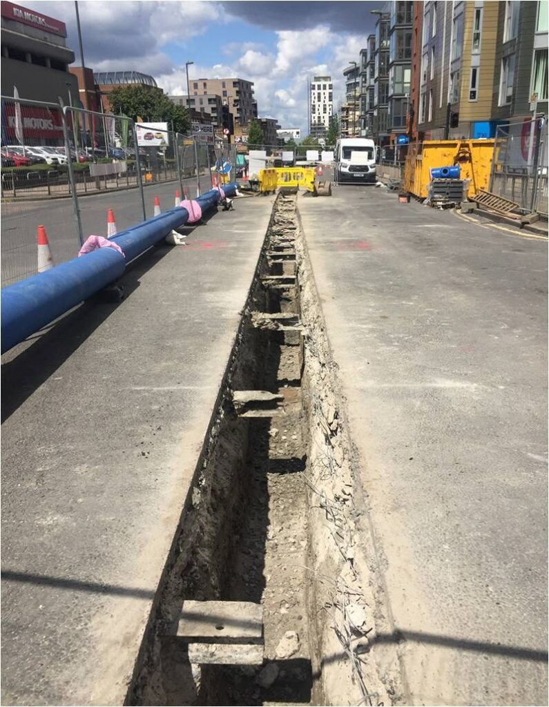
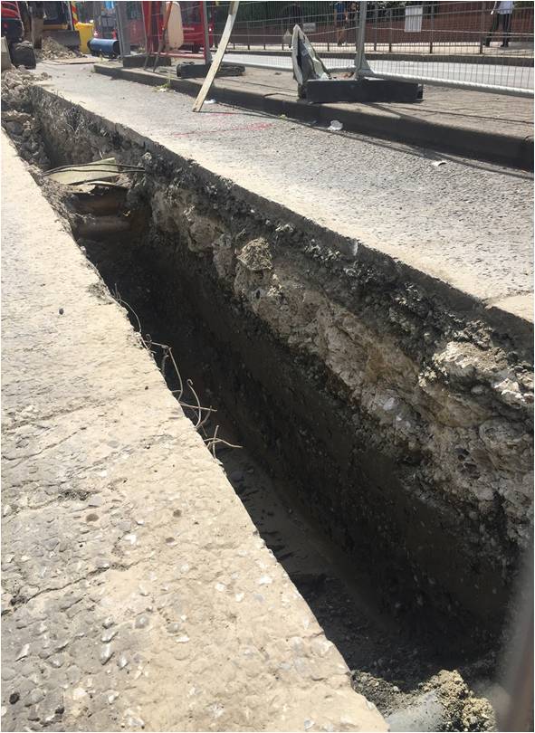
Old tram track rediscovered in Colindale Andy Simpson
Sometimes roadworks have rediscovered tram track underneath the road surface, exactly as it was when the tramways were abandoned and the concrete had just been put on top. But in some locations the track was removed and cut up into smaller sections to then be used to strengthen the road surface. One such location was Edgware Road in Colindale, where recent utility work by Affinity Water replacing large water mains has rediscovered these small sections of track once more.
The view north towards Burnt Oak showing the regularly spaced lengths of reused tram track.
7
Trams last ran along the
Edgware Road through Colindale and Burnt Oak to Edgware/Canons Park in 1936
when they were abandoned in favour of trolleybuses (which were themselves
replaced by motorbuses in January 1962) but the tracks remained in place
until during the Second World War when their removal was approved by Middlesex
County Council who originally owned the tracks in the area, to be undertaken by
Hendon Council sometime after November 1941 and presumably at that point cut
into smaller sections and used to strengthen the road surface rather than
simply going towards the wartime scrap drive which saw the removal of hundreds
of miles of abandoned tram tracks throughout the country at this time.
Back in the early 2000s
the same arrangement was seen by your scribe a mile or so south of this
location during similar works near the junction with Kingsbury Road. The
current works started around the Burnt Oak area and are gradually proceeding southwards
towards this point it seems from conversations with the contractors, who had
been warned of the presence of the tracks and were finding them very hard to
remove where occasionally necessary. By early August 2020 work had reached the
junction with Colindeep Lane.
I have also been examining the trenches for any sign of the original Roman road surface of Watling St. Near the junction of Colindeep Lane (see picture below) in particular there are two bands of gravel and small cobbles within the London clay visible in the trench sides but I am not sure they are thick enough for a road surface – certainly not comparable to the thick and regularly repaired road surfaces seen in urban excavations at any rate.
8
Elsewhere in the Borough, as previously recorded by Bill Bass, much of the double tram track and cobbled road surface remains in place up Barnet Hill, last used in 1938.
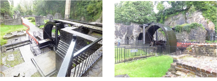
Water and our waterways were an essential
building block for the Industrial Revolution so we have visited a number of
canals and canal-side places. And a boat trip supplies a chance to relax and
rest your feet, as well as seeing the area from a different angle. We have also
been to a number of water mills and waterwheels.
Many of the places we have taken in
demonstrate the ingenuity of our predecessors, and many of these places have
been restored and are now run by volunteers. Long may they continue.
Starting from our Hereford excursion, we
visited the National Waterways Museum in Gloucester Docks followed by a 45-minute
trip on the Gloucester & Sharpness Canal.
2010 saw us based in Norwich and we included a
boat trip from Great Yarmouth to the Berney Arms Windmill and pub, located in
The Broads, and only accessible by boat. To make this journey, traffic on the
road bridge carrying the A47 had to be stopped so that we could pass through.
One lesson we learned here was that some
summer services stop when children return to school after their holidays.
However, when we ask for a trip for 30+ people, the service magically
re-appears JUST FOR US.
In 2011, we were based on the Isle of Wight,
so our out and back journeys included the ferry between East Cowes and
Southampton. Again we were able to arrange a boat, this time from Yarmouth, so
that we could visit Hurst Castle, one of Henry VIII’s forts on the mainland protecting
the entry to the Solent.
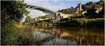
Ironbridge was our base in 2012, and what better way to see the bridge but a specially arranged boat trip on the River Severn going under the bridge. And our outing to the Blists Hill Victorian Town through which runs the Shropshire Canal provided the chance to walk along the towpath to The Hay Inclined Plane, effectively a funicular railway for specially adapted narrowboats, so that they could descend from the top of the hill to the River Severn below. And on our return trip to London, we stopped at the Canal Museum at Stoke Bruerne on the banks of the Grand Union Canal. Some of the party had a short boat trip up to and just into the start of the Blisworth Tunnel.
2012 took us to Buxton and during our visit to Cromford Mill, we had a brief chance to visit the end of the Cromford Canal, which is being gradually restored to Derby. Our next stop
9
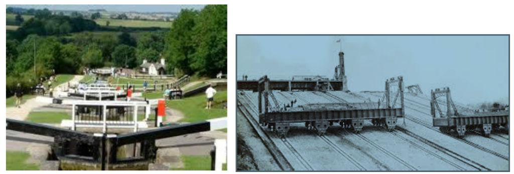
was rather wet, but by the time we reached Foxton Locks on the Leicester section of the Grand Union, the sun was out and we were able to visit the small museum, help a couple of boats through the staircase of locks, and investigate another inclined plane. There are 10 locks in two groups of 5. Passing is only possible between locks 5 and 6, otherwise you travel directly from one lock into the next.
Unlike the Hay Plane at Ironbridge, this
worked by moving a caisson full of water. Full size canal boats would drive
into the caisson and then be moved up or down the slope, thus bypassing the
staircase of locks and saving the boat up to 3 hours on their journey. Sadly no
longer working though restoration is planned.
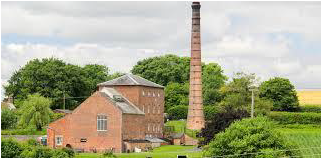
Our trip to Canterbury in 2014 did not have any planned water excursions, though Andrew and Liz Tucker managed a trip on the River Stour, and we did visit lifeboat stations at Dungeness and Whitstable, and we saw the Dover bronze age boat. Lyndhurst in the New Forest was our base in 2015. Our first stop on the way was the Crofton pumping station on the Kennett and Avon Canal, and we had arranged for this to be in steam and operation while we were there. This Edwardian pumping station was built to pump water to the highest point of the canal, and while most of the time this task is performed by electric pumps when the station is in steam, it performs the task for which it was built, and the electric pumps are turned off. When on one occasion the electric pumps both failed, the volunteers were called in since without the supply of water the canal cannot function.
Later in the trip, we visited Bucklers Hard
and had a boat trip on the Beaulieu River. Our final stop on our way home was
to Whitchurch Silk Mill on the River Test, giving us the chance to see the
waterwheel in operation.
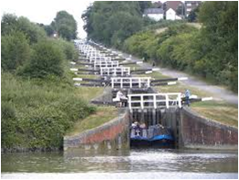
2016 saw us further along the Kennet and Avon, based at Bradford on Avon. Our journey down included a stop at Devizes, with a small Canal Museum among the options to visit. Then via the brewery on the canal bank, to stop briefly to view the Caen Hill Flight of locks. There are a total of 29 locks raising the canal 237 feet in 2 miles, but the flight contains 16 close locks in a straight line, with only passing places between them.
10
Bradford also boasts a splendid Tithe Barn
right next to the canal.
The highlight of this trip was a visit to the pumping station at Claverton. Then under restoration by volunteers, and now operational, it uses a waterwheel on the River Avon to pump water from the river to the canal – completely green energy. The pumping station is not accessible by coach, so we chartered a narrowboat in Bath to make the hour and a quarter trip each way to Claverton, with a cream tea on the return leg.
Frodsham was our base in 2017, in a hotel with a splendid view across the Mersey, and the Manchester Ship Canal to Liverpool. A stop on route at Redditch to visit a needle mill, powered by another waterwheel. From Frodsham, we went to Norton Priory on the banks of the Bridgewater Canal, the first to be built in Britain, so that coal could be taken to Manchester. We continued to the Lion Salt Works near Northwich, on the banks of the Trent and Mersey Canal. Salt from here was exported round the World, initially by barge which would have used the Anderton Boat Lift, our next visit. This double lift raised/lowered boats between the canal and the River Weaver, giving a faster way to the Mersey. We rode the lift downwards with a full commentary.
11
Our trip home included a stop at the Cheddleton Flint Mill on the side of the Caldon Canal. Here, nodules of flint arrived by boat to be ground by the two still working waterwheels for inclusion in the clay for potteries in nearby Stoke.
Our planned boat trip in 2018 while we were at
Brome had to be cancelled because of high winds, but we did manage to visit the
tidal mill at Woodbridge and see it working. At high tide, the river fills a
small reservoir. This is emptied at low tide to drive the mill to grind flour..
Last year, we were based at Aberavon on the
shores of Swansea Bay, and started our day in Swansea with a trip on the River
Tawe. The Welsh name for Swansea in Abertawe which means the mouth of the River
Tawe. And our first trip on our final day was to a different type of water –
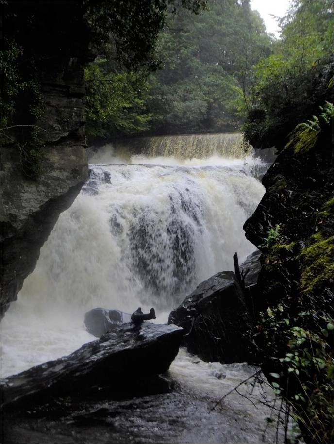
the waterfalls at Aberdulais in the Neath Valley. Aberdulais, the mouth of the
River Dulais where it joins the Neath River, has had a number of industrial
uses, but today the waterwheel driven by the falls is, at 27ft diameter, the
largest wheel in Europe generating electricity.
Quite a selection of places. Most are written up in more detail in our newsletters which can be searched on our website www.hadas.org.uk. If anybody would like further information on any of them and may want to visit, please contact Jim Nelhams (020 8449 7076).
Reminder: Our Annual General Meeting could not take place in June due, of course, to the coronavirus situation and we still do not know when it will be possible to arrange another date. Meanwhile, the committee remains in place. There will also be no Tuesday lectures until further notice. However, the monthly Newsletters should continue as usual.
Your Newsletter needs YOU
This is your
newsletter – it is for you and about you, your interests and your Society. In
the last twelve years, many members have volunteered to write-up parts of our Autumn
trips, giving interesting and varied material for newsletters over the winter
months. This year, it will not happen, nor do we have any lecture write-ups, so
we have gaps to fill.
You can help put this
right by sending in your articles about places or things of interest.
The editor of the next newsletter is always shown at the end of the last page. You can send things to them, or to Jim Nelhams (jim_nelhams@hotmail.com). If you need a little help, you can talk to Jim on 020 8449 7076.
Hendon & District Archaeological Society Finds GroupCourse Tutor: Jacqui Pearce BA FSA MCIfA
A 22-week course in post-excavation analysis to be held at Avenue House, 17 East End Road, Finchley N3 3QE on Wednesday evenings, 6.30–8.30, starting on 7th October 2020
make cheques payable to
HADAS and send to Don Cooper, 59 Potters Road, Barnet EN5 5HS.
Reopening
As the lockdown is
loosened, places are gradually re-opening though with appropriate precautions.
At this time, you may be unwilling to travel on public transport, but there are
some places you can reach by car, and you can start planning future trips.
All the following
museums/galleries appear to be open but check because the situation may change.
Foundling Museum
London
Transport Museum’s Depot in Acton will reopen for visitors to explore for its
first ever summer season! This trove of transport treasures will now be open
for 10-days of summer family fun from Wednesday 19 to Sunday 23 and Wednesday
26 to Sunday 30 August 2020. (The main museum in Covent Garden remains closed.)
Museum of London
Museum of Docklands
National Army Museum,
National Gallery
Natural History Museum
(closed Bank Holiday 31st August)
Royal Academy
Science Museum from 19th
August.
Tate Britain and Tate
Modern
Victoria and Albert (selected galleries open from 6th August)
Most of these will have one way systems and may need to be pre-booked and will not have any catering facilities available – so you may need to take your own food.
Most
gardens are now open, and houses are being added to the open list.
Epping Ongar
Railway
Getting Back on Track – Fridays, Saturdays, Sundays and
Bank Holiday Monday in August
Take a scenic ride through the Essex countryside and into the ancient Epping Forest on board our diesel multiple unit, which offers panoramic views. See how much wildlife you can spot, and if it’s sunny you might be able to get a great view over London as you pass over what was formerly the highest point on the London Underground network! (Bookings needed)
From their
website – “The Museum of London is on the
move. We want to tell the extraordinary story of London and Londoners in a new
museum in West Smithfield, which is itself a deeply fascinating and historic
area.
We want to engage Londoners and visitors with their city and its history, giving them the means to participate as citizens in all sorts of new ways. We want to display many more objects in a more meaningful way.”
The
new museum site, which will be nestled in London’s potentially transformational
Culture Mile development, has been conceived as a way to attract new audiences
and connect a greater number of visitors with the institution’s London
Collection.
Planning approval comes four years into the project, with work to this point having been led by Museum of London’s design team, architects Stanton Williams and Asif Khan, and conservation architect Julian Harrap. The local community, museum visitors and London residents have been consulted at every stage as the plans were formulated.
3
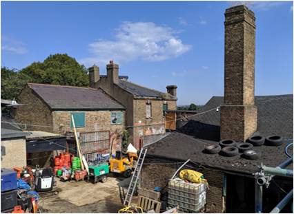
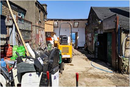
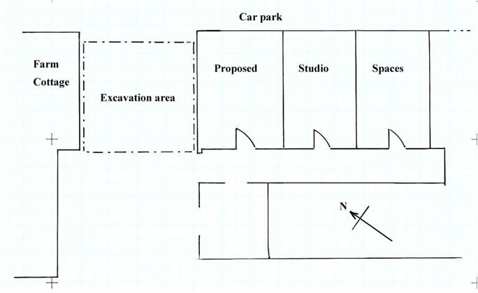
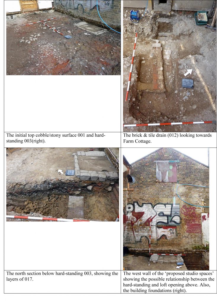
Excavations at Clitterhouse Farm, Cricklewood by HADAS in 2019 (Part 9) Bill Bass and Melvyn Dresner
This is a collection of photos from the excavation mostly by Melvyn, please see Newsletter June 2020 (591) for the full report, the dig took place August 2019.
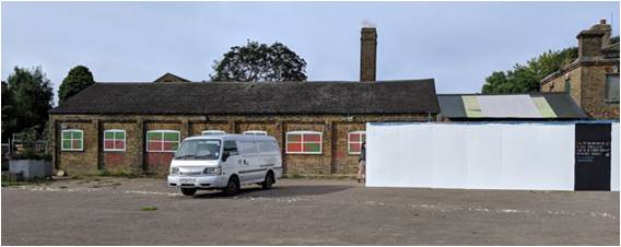
HADAS hard at work in what were very hot conditions, some form of community filming is also in progress. We are looking north. The car park is beyond the blue hoarding. This shows most of the excavation area.
Again looking north, the dig is to the right between the building with the chimney and the building beyond which is ‘Farm Cottage’. This we speculate is an entrance to the older medieval farm complex.
4
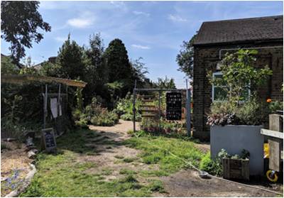
The dig is in the middle with ‘Farm Cottage’ left, the area is being redeveloped into a permanent cafe and studio spaces (in the right hand building) for the Clitterhouse Farm Project.
Here we are looking west, the structure to the right is the ‘New Farmhouse’ which faces on to Claremont Road, now a private residence.
5
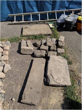
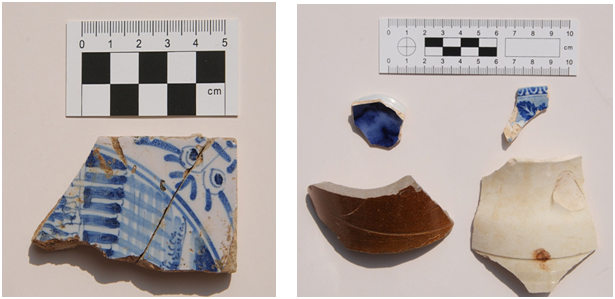
The remains of the hard standing feature 003, after being lifted, the cobbles and flagstones were saved for reuse by the farm project.
This photo taken from the car-park looks west into the first area we dug in 2015, now a flourishing community garden by the Clitterhouse Farm Project.
6
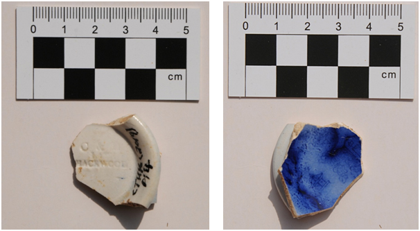
Looks like a stage-setting – ‘Poor Yorick I knew him well’….
Both the above photos show the C&H Hackwood impressed foot rim of Transfer Printed Ware, mid 19th century. Context 014 (Photos BB).
7
Left: Delft wall tile from context 017, c 18th century (Photo BB). Right: Selection of pottery including stoneware and Transfer Printed Ware. (Photo BB).
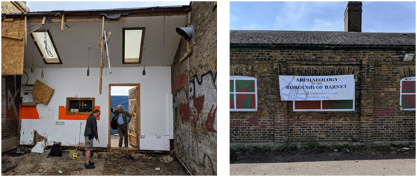
Looking west, the hoarding fronts the excavation area, to the left the building will be used for new studio spaces, in front the late lamented dig van (Photo MD).
Dr Brian Robertson Jim Nelhams
Always nice to hear
information about past members.
Earlier this month,
our Secretary received an email from Dr Brian Robertson OStJ, TD, MICPEM. Dr
Robertson explained that he had stumbled across our website while looking for
something else related to Hendon. A past
HADAS member, he had noticed that the 1964 excavation at Church End Farm,
Hendon was not included in the list of past excavations. (Omission now
rectified).
The various digs at the Church End Farm site are documented in “The Last Hendon Farm” published by HADAS. Copies of this are available through Don Cooper (contact information on back page of newsletter) and a copy has been sent to Dr Robertson. The first, in 1961, was directed by Ian Robertson, brother of Brian, Their father was an Army officer.
8
Ian held a number of
posts, ending as Director of the National Army Museum in Chelsea. He also
served as an infantry officer in the Territorial Army, serving in the 7th
Middlesex Regiment, and later the 4/5th Essex Regiment. He died in
2003. He also had an interest in postal history and served on the Post Office
Heritage Board.
Brian also shared
interests in both archaeology and postal history. He directed the digs in
Hendon in 1964 and 1966, though archaeology was not be to his career. He has
kindly sent us copies of publications covering some of his archaeological work,
including one on what he describes as his major personal piece of work, “The
Investigation and Excavation of Roman Road No. 167 in Copthall Fields”. These
will be added to our library at Avenue House.
In 1970, he moved to
Medical School, subsequently joining the Army and serving abroad in British
Army on the Rhine. He was Squadron Commander of the Ambulance Train Squadron, Royal
Army Medical Corps(V) between 1985 and 1994, responsible for ten such trains.
He is documented as recently lecturing to the Forces Postal History Society on the subject of Ambulance and Hospital Trains, going back as early as the Crimean War in 1855. Sounds like an interesting topic.
Down the Tubes at Christ’s Hospital. Jim Nelhams
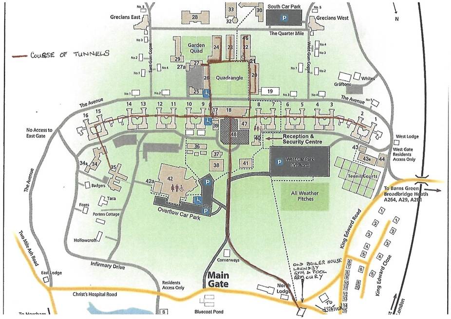
“Down the Tubes” has
different meanings for different people, but for pupils and alumni of Christ’s
Hospital, it particularly refers to a series of underground tunnels linking all
of the 16 main boarding houses and most of the other major buildings which make
up the school.
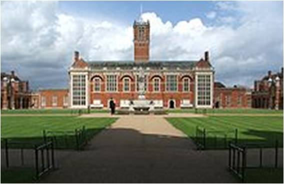
Christ’s Hospital was
founded in 1552 and granted a Royal Charter by Edward VI in the following year
with St Thomas’ Hospital and Bridewell Hospital and was on the north side of
Cheapside in the City of London, initially occupying the disestablished
Greyfriars Monastery.
When St Thomas’ moved
in Victorian times to new buildings in Lambeth, opposite the Houses of
Parliament, the architects took into account the “pavilion principle” espoused
by Florence Nightingale in her “Notes on Nursing”. This meant that the hospital
was built in 6 blocks 125 feet (38m) apart and joined by low level tunnels.
This was intended to improve overall ventilation and to separate and segregate
patients with infectious disease.
In 1902, the school moved to a new location two miles south of Horsham in North Sussex, with new appropriately designed buildings. To each side of the main school buildings runs an avenue some half mile long, on the north side of which stand the eight main boarding blocks, each containing two boarding houses. These are appropriately spaced following the example of St Thomas’ and are all joined by underground tunnels. The tunnels also lead to nearly all of the main school buildings from that era. When I was there, these could be used to reach the Dining Hall, Chapel or Classrooms in inclement weather. During WW2, they also served as air raid shelters.
9
The Dining hall (No. 18 on map – top centre)
When asbestos was discovered in the tunnels, most of them were closed off while it was removed and they are still officially inaccessible to pupils.
Christ’s Hospital map showing tunnel system.
10
The tunnels still
serve as the main service ducts throughout the school, carrying water gas and
electricity cables and more recently, internet connections. This saves a large sum
of money since repairs can be made without the need for any digging from the
surface. At one time, the water supply came from the school’s own underground
reservoir on a nearby hill. Connecting tunnels also led to the school
infirmary, and a longer one to the boiler house which provided hot water and
heating to all the buildings, with a short extension to nearly reach the school’s
railway station.
Last year, we
discovered that Stewart Wild’s father-in-law had been head boy (“Senior
Grecian”) at the school and I was able to obtain some information about him
from the school’s museum and archive. When a chance occurred, Jo and I took
Stewart to visit the school. Knowing that Stewart was a member of Subterranea
Britannica (Sub Brit), an organisation dedicated to things underground, we told
him about the tunnels and watched his eyes light up. We also gave him a contact
at the school.
While tours are not
normally available, the reputation of Sub Brit enabled them to arrange a
special group tour which took place earlier this year in the February half-term
break. Our group of 6, plus two members of the school’s museum staff who had never
been down the tunnels, was conducted through parts the system by Building
Maintenance Manager Neil Manning for two and a half hours, during which time,
we travelled about one mile underground, but had seen less than half of the
network. The trip was written up with many pictures in Sub Brit’s, April
edition of their magazine occupying nearly 6 pages with a picture on the front
cover.
It was very revealing to see what services are needed to run a large boarding school of some 850 pupils.
Weekly News Sheets
The weekly news sheets have been
discontinued. These were intended to pass on tips for use during the lockdown.
For reasons of cost, they were not posted to people for whom we had no email
address on file.
The news sheets included a number of Lockdown Jimericks including some of the following:
Reminder: Our Annual General Meeting could not take place in June due, of course, to the corona virus situation and we still do not know when it will be possible to arrange another date. Meanwhile, the committee remains in place. There will also be no Tuesday lectures until further notice. However, the monthly Newsletters should continue as usual, as well as Jim Nelhams’s regular informative, enjoyable and sometimes mind-stretching updates. These separate news sheets are only being emailed. If you are not getting a copy, please email Jim, address on back page.
Curing the Plague Peter Pickering
Our Prime Minister is known to be keen on Latin. I
wonder if he is modelling himself on the emperor Titus (one of the few who have
had a good press). Faced with a plague Titus, according to his biographer
Suetonius, “did not refrain from any means, human or divine, for
restoring health and alleviating sickness, trying every medicine and every kind
of sacrifice.”
Whether he was successful or not in these efforts is not recorded.
Council for British Archaeology Sue Willetts
The annual Council of British
Archaeology festival normally takes place in July and this year there will be
digital events from 11-19 July and, if it proves possible, a further week of
events on the ground from 24 October to 1 November 2020. The theme is Climate
and Environment.
Events posted so far include: Two online tours of Roman London (11th July and 15th July); Archaeology from home with Emma Cunliffe using space technology (13th July); The campaigns of Septimius Severus in the far north of Britain (14th July). Their website is https://festival.archaeologyuk.org
Other Societies’ and Institutions’ Events
This section is temporarily cancelled due to the coronavirus outbreak. However overleaf is the announcement from Don Cooper of HADAS’s very own offering: the next Finds in Focus course, run by Jacqui Pearce.
1
The Next Finds in Focus Course Don Cooper
Hendon & District Archaeological
Society Finds Group
Course Tutor: Jacqui Pearce BA FSA MCIfA
A 22-week course in post-excavation analysis to be held at Avenue House, 17 East End Road, Finchley N3 3QE on Wednesday evenings, 6.30–8.30, starting on 7th October 2020
This year we will be focusing on recording the finds
from an excavation carried out by Birkbeck College in 2001 that has not been
published. We are aiming to identify,
record, rebag and re-label all the finds including Pottery, Glass and Clay Pipe
to Museum of London standards. Regular presentations and professional tuition
will be provided throughout the course. This is an ideal opportunity to gain –
or increase – your experience of working with and handling a wide variety of
archaeological finds. Teaching sessions on the various types of finds will be
complemented by practical handling and recording sessions. Our aims are to
introduce the various types of finds and provide hands-on opportunities to
become more familiar with post-excavation procedures.
All are welcome – it doesn’t matter whether or not you
have experience of working with archaeological finds!
Course fee: £295 for 22 sessions. To book, contact Don Cooper (olddormouse@hotmail.com; tel. 020 8440 4350) or Jacqui Pearce (pearcejacqui@gmail.com; tel. 020 8203 4506). Please make cheques payable to HADAS and send to Don Cooper, 59 Potters Road, Barnet, EN5 5HS.
2
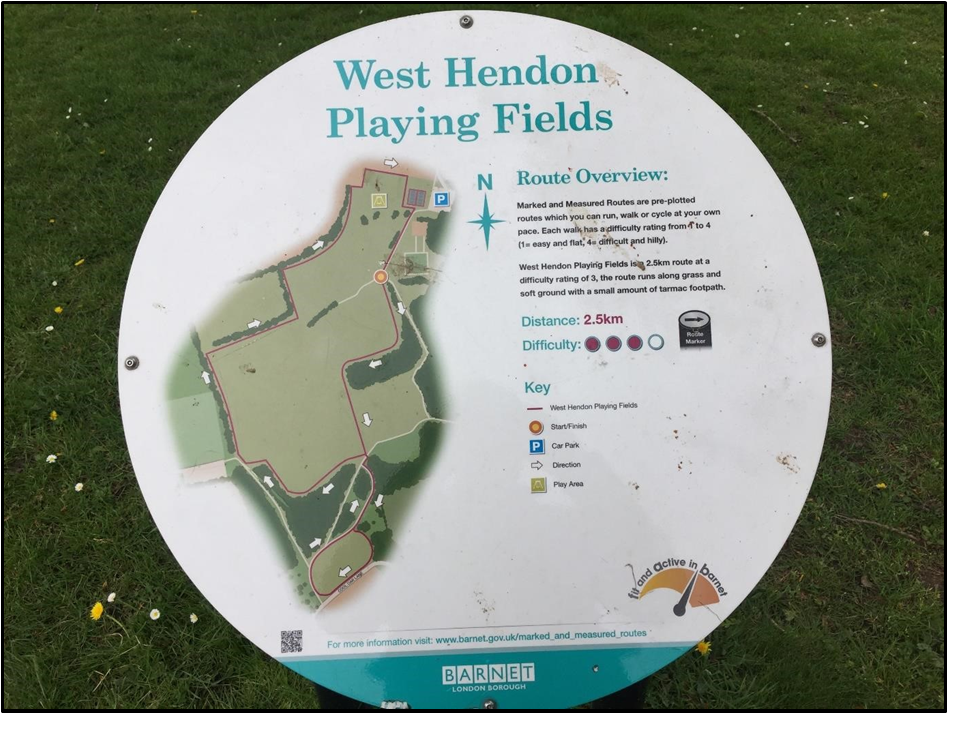
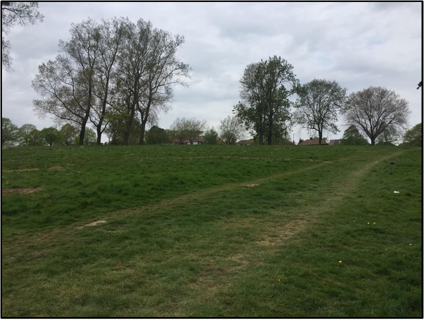
ON THE FRINGE – WEST HENDON PLAYING FIELDS Andy Simpson
Under the current coronavirus restrictions, I have since
April 2020 taken a number of my permitted exercise walks around West Hendon
Playing Fields, shown in Figure 1, a convenient 10-minute walk from my
flat.
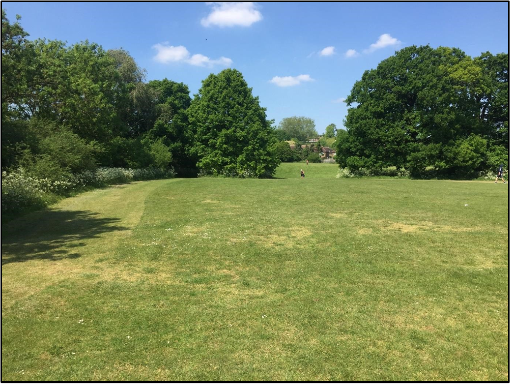
These very pleasant 62-acre playing fields are just within Barnet Borough. Directly adjacent is the Silver Jubilee Park,which houses Hendon FC at its southern end. This is in Kingsbury which is part of Brent. Both appear to have a significant history which may well be worth investigating further, particularly as the playing fields are due for updating, and some ground works under a new Barnet Council scheme were approved early in 2020 following public consultation.
The Borough boundary between Barnet and Brent isalso a long-standing field boundary, marked by the substantial north-south hedge line that divides the playing fields from the park. As summarised below, the site does have some history. To the south it includes Cool Oak Lane, referred to as Cold Duck Lane on some early maps, which divides the playing fields from the main area of the Welsh Harp (Brent) Reservoir. The reservoir was originally just a feeder from the River Brent at Kingsbury dug in 1809/10 when the Grand Junction Canal Co. needed water for their canal at Lower Place, Willesden.
3
In 1833 the Regent’s Canal Company decided to build the
reservoir to supply the Paddington Canal at Harlesden, which opened in 1838.
They did this by building a dam at Kingsbury to form the reservoir in 1835-39
using the existing feeder.
Late Bronze Age
‘cinerary urns of the Ashford type’ were found on the Kingsbury side of the Welsh
Harp/Brent Reservoir around 1930 at grid reference NGR TQ218872 and, during
lowering of the water level and strengthening of the banks of the reservoir in
1974, members of the Wembley Historical Society found a copper as of Constantius II who reigned from
AD337-361. (The as is a coin worth a
quarter sestertius).
The playing fields and the neighbouring Silver Jubilee Park
run roughly parallel with the Edgware Road, bounded in the north by the
east-west Kingsbury Road, close to where it joins the Edgware Road in
Colindale. It is here that our friends
the Romans enter the scene – much of the western border of Hendon being, since
the time of the Medieval Parish of Hendon, formed by the line of the Roman Road
from London to Verulamium and the Midlands, later named Watling Street in Saxon
times and today called the Edgware Road, except in the area of West Hendon with
part of the Welsh Harp and the Cool Oak area where there is a pronounced
‘bulge’ to the west away from the line of the road.
Sherds of Roman pottery were apparently found at the site of
the former Hendon Isolation Hospital in Goldsmith Avenue, south of the
Kingsbury Road, which is close to the Edgware Road and runs down towards Fryent
Fields and the north end of the West Hendon Playing Fields – at grid reference
TQ 213884; HER ref 081917. They were actually reported by Ian Robertson of the
Passmore Edwards Museum and a HADAS member who directed the HADAS excavation at
Church Farm.
The former isolation hospital, latterly a
geriatric hospital by 1970, was built in 1929 , expanded by 1940, but
demolished in 1984 and replaced by housing; see
http://www.ezitis.myzen.co.uk/hendonisolation.html
In Domesday book the whole Parish of Hendon was in the Hundred of Gore, held by Westminster Abbey, the boundaries seemingly largely fixed by the late 10th century. Hugh Petrie, in Hendon & Golders Green Past, and the Victoria County History (VCH) volume on Middlesex record that from 1442 All Souls College, Oxford, owned considerable amounts of land in Hendon, Edgware and Kingsbury, in scattered parcels giving a total of 224acres.
West Hendon Playing Fields were originally part of an estate
given to the Knights Templar in 1243, passing to St Pauls Cathedral in 1544,
the 110 acre estate being leased to the Duke of Chandos and his descendants in
the 18th Century. In 1872 it was vested in the Ecclesiastical
Commissioners and most of it was sold to Hendon U.D.C in 1919 for use as the
West Hendon Playing Fields and park.
On the 1896 one-inch OS Map the general area south of Kingsbury Road is marked as Townsend; today the western edge of the Silver Jubilee playing fields is bounded by Townsend Lane. Open country still stretched south from West Hendon to Cricklewood railway sidings in 1914, while the badly drained ground on the Kingsbury border never attracted housing. Latterly known as Reets Farm, producing hay for the London market by 1894, the playing fields area became Kingsbury Lane Playing Fields after the sale to Hendon Council in 1919. Since 1924 it has been called West Hendon Playing Fields. As noted in the Middlesex VCH, in 1932 Hendon Borough Council owned 793½ acres of open spaces in Hendon and Edgware including Moat Mount open space (67 a.), Arrandene Park (57 a.),
4
Watling Park
(46 a.), Montrose Playing Fields (30 a.), Copthall Park (146 a.), West Hendon
Playing Fields (62 a.), Woodfield Park (40 a.) and Clitterhouse Playing Fields
(50 a.).
Shown on the 1873 6-inch
Ordnance Survey map under its earlier name of Rise Farm, https://maps.nls.uk/view/102345949 Reets farm is shown on the 6-inch OS map for
1897 https://maps.nls.uk/view/101454874sitting just below the sloping 200ft
contour line. By 1935-6
when the map was revised on the eve of sale of the land to Wembley U.D.C as
Silver Jubilee Park, it had been demolished and the site cleared.
The Reets
Farmhouse and outbuildings still survived amongst trees in 1929, with post-1912
allotment gardens between it and the Kingsbury Road in the area near the top of
what is now the Silver Jubilee Park playing fields, and its former farmland
area was occupied by the park, West Hendon Playing Fields, a nursery and allotment gardens. See https://www.british–history.ac.uk/vch/middx/vol5/pp11–16
The farm is commemorated by a street name, Reets Farm Close, near Goldsmith Avenue and the junction
of Kingsbury Road and Edgware Road.
Fig.2 View of site of Reets Farm, up-slope towards Kingsbury Road
For a view of Reets Farm see image at Barnet archives web page.
Today the West Hendon Playing Fields remain a public park with several football pitches forming a large grassed area and with scattered mature trees.
5
There are two quite marked hedge lines – one of them running
north-south dividing West Hendon Playing Fields from Silver Jubilee Park and
forming the Borough boundary, the other an east-west ditch, bank and tree line
at the northern end which may be of some age, dividing the site in two. Both
are clearly shown on the Ordnance Survey first edition 6-inch map of 1873 with
no other hedge lines at that point crossing what is now the park. The eastern
boundary of what is now the playing fields was formed by the Edgware Road on
the 1873 map.
Rocque’s 1756 map of Middlesex appears to show the same
hedge lines/boundaries; at this time the area was held by St Paul’s Cathedral
and All Souls College.
In the West Hendon fields there is a distinct rectangular area at the NW corner, bounded by the above mentioned hedge lines. At the northern end of this field the dry weather of May 2020 revealed a very distinct east-west parch mark showing as a slightly raised bank on the ground. It appears to be a former roadway of unclear date that runs from a northern pedestrian entrance to the park and terminates at the north-south hedge line.
Fig. 3 View north, with east-west hedge line meeting north-south borough boundary, with site of Reets Farm visible on slope through gap in hedge
There is a pleasant area of woodland at the southern and eastern edges of the playing fields. There are also two tennis courts, several football pitches, a children’s playground, a private bowls club, and a car park.
6
The Eastern boundary of the playing fields is formed by the
northern arm of the Brent Reservoir up to the Edgware Road where it narrows to
become the course of the Silk Stream.
The reservoir was enlarged between 1851 and 1853, though
part of the northern arm reaching north-east of the Edgware Road was reclaimed
when the stream under the road was culverted in 1921.
The area at TQ21487 (Cool Oak Lane) was the
site of landfill – recorded in data from the British Geological Survey supplied
to the Environment Agency. It is not known whether this site was made or worked
land, and the date of the infill is unknown, although all finds were of 19th/20th
century date, suggesting it was part of this work. https://edithsstreets.blogspot.com/2012/12/silk–stream–west–hendon.html .
During the London Blitz September 1940-June 1941, the area
of the playing fields was hit by at least three high explosive bombs near
Fryent Grove and Goldsmith Avenue, and on the western side there is a heavily
disturbed area of ground with one or more possible bomb craters still visible on the ground, with at least
one more hitting the Silver Jubilee Playing Fields– see http://bombsight.org/explore/greaterlondon/barnet/west–hendon/
Former Royal Air Force Museum colleague Christopher Herbert
suggests that the bombs that hit the playing fields were intended for the AA
battery located in the adjacent Silver Jubilee Park to defend the nearby LMS
railway marshalling yards at Cricklewood.
The first bombs hit the outskirts of the Hendon area on 5
September 1940, with the nearby Hendon airfield and its environs being bombed
on 24-25 September and the nights of 7-8 October and 8 November, with sporadic
raids on the area until the Spring of 1941.
This latest version of the report includes some changes made
after the public consultation with various conservation bodies. It is intended
to install two artificial turf pitches at the southern end of the site which
may impact on any surviving archaeological features such as earlier field
boundaries.
In neighbouring Kingsbury by 1965 there were 262 acres of open space, most of which,
having also been part of the medieval Hundred of Gore, had also been acquired
from All Souls College, Oxford. The college sold the land forming Silver
Jubilee Park (36 acres) to Wembley U.D.C. in 1936 and Fryent open space (160
acres) to Middlesex County Council in 1938. Roe Green Park (20 acres) had been
acquired in 1934.
For a description of the hourglass-shaped Silver Jubilee Park see:
http://www.londongardensonline.org.uk/gardens-online-record.php?ID=BRE033 Grid ref TQ209881. It is bounded to the north by the Kingsbury Road, to the west by the hedge line separating it from the West Hendon Playing Fields, and to the East by Townsend Lane, which, as with the northern part of the park, rises steeply towards its junction with the Kingsbury Road, the boundary here being a modern hedge line.
7
Rather more recent is the site of the Second World War heavy
anti-aircraft battery located in the park, recorded in the 1990s CBA Defence of
Britain survey; heavy anti-aircraft battery ZW14 at Silver Jubilee Park, West
Hendon, was listed as armed in 1940-2. It was manned by 370 Battery of the
117th Royal Artillery Regiment in 1943. In 1946 it was retained as a Nucleus
Force Headquarters Battery.
The earliest date upon which the site is listed as present
within the sources is Feb 1940 and the latest 15 Jan 1946. The site was
unarmed/manning vacant in 1940; Regiment 71, Battery 325 on 30 July 1942;
Regiment 137 (mixed), Battery 476 on 9 Dec 1943. NGR ref TQ211881.
❖❖❖❖❖❖❖❖❖❖❖❖❖❖❖❖❖❖❖❖❖❖❖❖❖❖❖❖❖❖❖❖❖❖❖❖❖❖❖❖❖❖❖❖❖❖
With many thanks to
this month’s contributors:
Don Cooper, Peter Pickering, Andy Simpson and Sue Willetts
Hendon and District Archaeological Society
Chairman Don Cooper 59, Potters Road, Barnet, Herts EN5 5HS
The Annual General Meeting on Tuesday 9 June 2020 will not now take place due to the situation created by the coronavirus. At the present time we do not know when it will be possible to arrange another date. There will also be no Tuesday lectures until further notice. The monthly Newsletters should continue as usual. Keep well and safe until we meet again.
Layers of London Melvyn Dresner
Adam Corsini, of the Layers of London project https://www.layersoflondon.org/ gave a talk for HADAS on 10th March 2020, provided members with a practical session on how members can contribute and use this great resource. This website was funded by the Heritage Lottery Fund, and brings together an amazing set of historic maps, and databases useful to anyone interested in the archaeology and history of London. You can add to data by contributing existing projects or can initiate your own. You can explore the map or the collections. The website allows users to overlay maps and data from different sources and periods, varying the order and fade. Datasets include the Archaeology of Greater London; London’s Archaeological Investigations 1972 – 2017 and Historic Environment Record.
Excavations at Clitterhouse Farm, Cricklewood by HADAS in 2019 (Part 8, Investigations beneath the café area in the north corner of the farm complex) Bill Bass and the Fieldwork Team
Clitterhouse Farm, Claremont Road, Cricklewood, NW2 1PH. Site code: CTH16, NGR: TQ 2368 8684, SMR: 081929, Site investigated August 2019. For background on this project please see HADAS Newsletters 539 (Feb 2016), 542 (May 2016), 543 (June 2016), 544 (July 2016), 556 (July 2017), 557 (Aug 2017) and 579 (June 2019).
Please also see other maps in HADAS Newsletters 542, 543 and 556 etc.
1
Introduction
Clitterhouse Farm, a moated manor site, has a long documentary history. Archaeological research work is being carried out to try and establish the Saxon/medieval and later layout of the site and the surrounding landscape use. Following on from previous the work here, the Clitterhouse Farm Project was demolishing their temporary café to be replaced with a purpose-built structure and building of new studio spaces in the northern range of the farm. HADAS was asked to carry-out initial archaeological investigations after the café was demolished. The temporary café was built between a gap in the northern range and the ‘Farm Cottage’, although the farm buildings have been rearranged over the years this is thought to be the original farm entrance which led into the moated area from the south-west, at least from the 17th century and probably earlier as seen on various maps, also see Newsletter 543 (June 2016). The 2019 dig began with site-watching of the removal of the substantial concrete slab which covered the area approximately 6m (E-W) x 5.60m (N-S), this was carried out by the groundwork contractor’s machine.
Excavation
Some 15 members took part over the length of the dig, in sometimes very hot conditions, in fact the hottest week of the year. With the concrete removed the excavation started, beneath the concrete a sandy/gravel and cobbled surface began to emerge. This mixed layer (001) consisted of a sandy-silt with small to medium size pebbles and occasional larger ones, impressed into this were random large granite sett cobbles, with brick and tile scatters, some of this material was patchy, others were better sorted. The ordnance-level (OD) of this surface was 57.38m. Below (001) was (002) another patchy layer but with a better sorted pebble/cobble consistency in silty clay, about 0.08 – 0.14m in depth. Beneath this context a yellow-orange sandy layer (005) was uncovered which was relatively clean with occasional pebbles, this covered most of the excavation to a depth of 0.10 – 0.20m.
Not all features are shown for clarity.
Features seen beneath these upper layers but embedded in (005) include a rectangular shaped collection of large cobbles (granite setts?) surrounding two flagstones (context 003) arranged in rectangular shape 1.00m x 1.50m it was one course deep. This abutted the west end of the northern range wall. The unbonded cobbles and flagstones were reused,
2
they
had slots and notches cut into them, but we are not sure about their use.
Elsewhere on site we noticed concrete ‘door sills’, our cobble feature seems to
have replaced one of these (had the
previous sill been broken?), the truncated remains of which was could be seen
in the wall, perhaps a more heavy-duty hard-standing of some kind was needed
for hoisting materials to the loft hatch above.
Another feature excavated also surrounded by
the sandy layer (005) and possible pebble surface layers was an east – west
running brick and tile structure (012) on the east of the excavated area. The
end-on bricks lined some flat tiles, this may have been the remains of a brick
and tile drain, which was truncated by electric cable on the west side and by a
modern sewer pipe through the central area. It is difficult to interpret due to
the fragmentary remains, but we have seen a similar drain feature on a previous
dig here but that was more substantial.
Two
modern sewer drains crossed the site leading from a man-hole cover, it was
decided to partially excavate the east-west branch of one of these to confirm
this and to give an idea of the depth and nature of the section and deposits.
The 0.50m wide cut was dug and the pipe was indeed found at 56.72 OD, adjacent
to the north side were the remains of an earlier brick and tile drain. The
sections at approximately 0.60m deep showed bands of smaller pebbles in a
clay/sandy matrix.
On
the western side of the excavated area adjacent to the ‘Farm Cottage’ we had a
machine cut a slot of 4 x 1m, again to check the stratigraphy. Once again
layers of pebbles, clay and sand sat on top of the natural London Clay at
approximately 56.53 OD, Mike Hacker (pers comm.) comments – “I probed to
c1.80m below the level of the cobbles. It was consistently moist, stiff, mid
reddish-brown silty clay without inclusions. This is consistent with it being
London Clay”.
Along the walls of both ‘Farm Cottage’ and the opposite northern range building, we noticed the construction ‘cuts’ (004) for the foundations of the structures. These were dug in various places to reveal a three-brick course ‘stepped’ foundation sitting on some gravel packing and the natural clay, this is a similar arrangement to what was found in the 2015 dig. A trench was dug immediately south of the cobble and flagstone hard-standing which gave us sections below this structure, a section in southern area of the site and a section of the northern range building foundation. Initially this was done by hand and later extended by machine. The sections showed varying bands, deposits and layers approximately 0.60m deep of gravel, pebbles, occasional lager cobbles, brick and tile deposits with bands of silty clay of various colours, all given one context (017). A silty black clay deposit approximately 0.10m thick runs through the central area of the section sloping from east to west. The section appears to show a continuous depositing action of dumping, tip-lines, levelling, infilling and repairing of the farm entranceway down to the natural clay level. We also reached the ground water-table level here as seen in the ‘moat’ trench in 2015.
Finds & Dating,
not all contexts are listed here is a selection.
Context (001)
Pottery:
This upper layer beneath the concrete slab contained a variety of pottery,
mostly smaller sherds including Refined Whiteware, REFW – (china), Transfer
Printed Wares TPW, these have a general date of between 1800-1900. 8 English
Porcelain sherds ENPO, have a wider date range of 1745-1900. There were 76
sherds of English Stonewares ENGS 1700-1900, mostly jars including a small ink
jar, some of the sherds could be refitted, so some of the vessels were intact
when deposited. Some samples of Post-medieval Redwares PMR 1580-1900 were found
– mostly identified as flower pot.
Building Material: A selection of brick (whole or partial) were recorded, some glazed red tile, fragments of paving slab, peg and slate roof tile, mortar, sewer-pipe and other modern materials, were processed.
3
Stone:
A possible worked flint interpreted as a blade was recorded as Small Find
[005].
Animal bone: Four rib fragments showed
evidence of gnawing and cut marks, some oyster shell fragments.
Metal/glass: An assortment of modern window
and vessel glass fragments were recovered together with a variety of metal
objects including nails, copper tubing, window latches and others.
Context (004) wall foundation
cuts.
Pottery:
18 sherds of REFW including samples of dishes, cups and saucers, 4 sherds of a Yellow-ware
plate 1820-1900 and minor amounts of ENPO, PMR and a sherd of Tin-glazed Ware C
TGWC 1630-1846.
Other
finds included 51 sherds of roof tile, some brick and a floor tile. An unusual
find was a ‘lead weight’ domed in shaped, 118mm dia x 9mm depth, possibly a
‘greengrocer’s weight’ Small Find [001].
Context (005) sandy layer.
Pottery:
Sherds of YELL, ENPO, TPW4 and REFW with part of a figurine foot (? lion). A
ceramic bead, 11mm dia [small find 002]. 10 fragments of bottle glass including
neck and rim sherds. Small samples of brick and slate.
Context (006) modern
drain-pipe fill.
Context (012) brick and tile
‘drain’ feature
A
complete brick sample was retained from this feature: possibly hand-made with
no frog, it had possible organic tempering was red-purple in colour, possibly
dating to 17th– 18th C. The drain and brick may date to
before the current buildings and is similar to a drain seen in the 2015
excavations at the west end of the northern range.
Context (013)
and (014)
Both
these contexts were associated with the tile ‘drain’ (012) above, both, a brown
sandy clay with pebbles. They contained similar pottery finds TPW, ENGS, REFW
and SWSG Salt Glazed Stone Ware 1720-1780.
Of
the Transfer Printed Wares a foot rim of a bowl had a Chinese style building
design with the partial lettering ‘C&H HACKWOOD’. There were a number of
potters of that name in operation in the potteries, of one these Hackwoods – “In
1856, the works passed into the hands of Cockson & Harding, who
manufactured the same kind of goods, using the mark C & H, LATE HACKWOOD
impressed on the bottom. Cockson retired in 1862” (http://www.thepotteries.org/mark/h/hackwood.html, accessed
17/3/20).
Fragments
of a late 18th century ‘Mallet’ bottle were recorded as well as
small amounts of peg/roof tile, nails and animal bone.
Context (017)
This
mixture of contexts (see above) was deposited above the natural clay.
Pottery:
Small sherd examples of PMR, ENGS – bottle, TPW- plate and saucer, CREA
Creamware 1740-1830 plate and bowl and REFW – bowls.
Building
materials: consisted of fragments of brick, pantile (roof), a substantial but
incomplete floor tile and some drain pipe. An unusual find here was 2 sherds of
co-joining Delft, blue on white decorated Wall Tile, with one corner design of
part circle with the feet of two male figures, c 18th century, Small
Find [006]. An amount of corroded metal ‘sheeting’ was found together with a
hefty iron spike and nails.
Animal bone: fragments of rib, horn and a cattle-pubis were recorded together with some oyster-shell.
4
Other
finds included minor amounts of bottle and mirror glass, and parts of shoe
leather.
Interpretation
The
earliest features would appear to be the remains of the two brick and tile
‘drains’. The first, just seen in the north section of the modern drain cut
(007), the fragmentary remains of this feature was truncated and disturbed by
its more modern replacement. The second (012) excavated in plan and at a higher
level was again disturbed, a complete brick sample (described above) indicates
this ‘drain’ was constructed of reused materials because the brick was worn and
had 17th– 18th century
features, but the layers it was dug into were of mainly 19th century
in date. It’s possible the brick may be part of the demolition rubble from the
nearby ‘wheat barn’ excavated in 2016 (HADAS Newsletter 556). As with a similar
drain excavated elsewhere in 2015 this may be the remnants of the drainage
system of the farm complex before “in the late 19th to early 20th century the
main farm building is rebuilt in brick into a dairy farm.”
The
other features were recorded – the granite cobble sett hard-standing, and the
building foundations are described above. But for the most part much of the
area was made-up of bands of pebble surfaces, cobbles, sand/clay deposits and
dumps of brick and tile. All the layers had a mixture of finds dating to
c1700-1900 and were all disturbed. These layers were excavated to a depth of
80cm and were sitting on top of the natural clay. Local geologist Mike Hacker
commented in 2016 and it’s worth repeating “The well-rounded flint pebbles in
the cobbled surface look as if they may well have come from the nearby deposits
of Dollis Hill Gravel. One of the characteristics of DHG is that it is a poorly
sorted mix of clay, silt, sand and pebbles.
This makes it ideal for use as ‘hogging’ for roads and paths”.
Most
of the finds were 18th – 20th century in nature (and
later) with no sign of the earlier phases of the farm. It appears much of the
area has been disturbed and truncated as part of the re-ordering history of the
working farm and its buildings.
Acknowledgements:
Paulette
Singer & The Clitterhouse Farm Project; HADAS Fieldwork Team (including
site supervisors Andy Simpson, Melvyn Dresner and Roger Chapman); HADAS
Post-Excavation Team; Gerald Gold & team, groundwork contractors; Mo – Tool
Hire business owner and employees; and Mike Hacker – geologist.
HADAS Newsletter
reports on Clitterhouse Farm investigations.
539:
Part 1 – Introduction and Timeline.
542:
Part 2 – The Excavations (2015).
543:
Part 3 – Site Phasing and other things.
544:
Part 4 – Report on the Animal Bone and Marine Molluscs and some small finds
photos.
556:
Part 5 – Investigations of the north corner of the farm complex (2016).
557:
Part 6 – More information on a find (Char Dish) from Clitterhouse Farm.
579:
Part 7 – History of Clitterhouse Farm, Hendon (lecture report).
During the dig, HADAS made a record of the standing buildings, a report on these findings will be published in a future newsletter.
5
6
What did you do in lockdown – another option? Don Cooper
For
some time past, there has been a small hole in our lawn at the back of our
house. Every time I fill it in the local fox (or some other animal) digs it out
again. I wanted to know why the animal wanted to keep digging there and nowhere
else in the garden.
So
when that lovely spell of fine weather came along I determined to find out what
was happening underground and being in lockdown and having little else to do I
decided to do the project as a proper archaeological dig.
On Tuesday 14th April 2020 I marked out a 1m by 1m trench at TQ25866, 96442. I put down a tarpaulin for the spoil heap, oriented the trench north south, got the tools out including my trusty trowel and made a start de-turfing. By the end of the day I had made a good start on the trench as can be seen from the photo below.
On the next day I started
bright and early at 10.30am. Digging down 20cm and turned up lots of finds of
pottery, building material, clay pipe, window glass and animal bone. One
totally surprising find was a hen’s egg with a green stamp! The egg was in a
small hollow surrounded by leaves and twigs. I took the photo and left it on the
spoil heap; it was gone next morning. How it got there and who deposited it, I
haven’t the faintest idea. Most eggs as far as I know are stamped in red. It
might explain why an animal kept digging out the hole.
By the end of day 2, I was down about 30cm all round. The southern section was showing a lot of building material in the form of brick, tile and sewer pipe.
On
day 3, as I continued down, there were few finds and at just over 40cm down I
came to the iniquitous London clay. I then dug a small sondage to be sure that
I had reached natural.
On
day 4, I decided to extend by 0.5m south to explore the building material
tumble. I measured out the extension and deturfed. This was easy digging as
there was a good deal of building rubble. Again, I dug down until I reached the
London clay, which appears to be the natural.
On day 5, I backfilled the trench and restored the turf.
7
I
spent day 6 washing the finds and recording them on an Excel spreadsheet. I disposed of much of the finds having
recorded them. I photographed samples see below.
In summary, there were 101 sherds of pottery (many of them very small) weighting 449 grams. They consisted of post medieval redware (PMR) mostly flowerpot, refined earthenware (REFW), transfer-printed ware (TPW), and English stoneware (ENGS).
There were four sherds of
clay pipe stems.
There were 63 sherds of glass mostly window glass (although there were 3 different thicknesses), but some bottle glass both green and white, as well as a sherd of a lovely scalloped bowl. The glass weighted 210 grams. There was a substantial amount of brick and tile.
There were a couple of animal bones and a small number of rusty nails.
My speculative conclusion is after looking at the deeds of the house, which was built in 1888, I think the builder’s rubble and hence the artefacts date from that period. I did not find anything earlier or anything that could not fit into that timescale.
8
The dig was a splendid experience. The weather was perfect, the ground reasonably soft after so much rain. I was outdoors and got lots of exercise and who cares if the lawn does not look great! I would recommend it to anyone!!
Æthelflæd, the Lady of the Mercians Dudley Miles
June marks the anniversary of Æthelflæd’s death; Dudley Miles tell her story 1150 years since her birth
Æthelflæd, who was the eldest child of King Alfred the Great of Wessex and his Mercian wife, Ealhswith, was born around 870, just before the Viking Great Heathen Army invaded England. By 878 they had conquered Northumbria, East Anglia and the eastern half of Mercia, but in that year Alfred won a crucial victory at the Battle of Edington. Ceolwulf, the last king of Mercia, is not recorded after 879, and he was succeeded as ruler by Æthelred, Lord of the Mercians. In the mid-880s he submitted to Alfred’s overlordship, uniting those Anglo-Saxons who were not under Viking rule. Alfred sealed the alliance by marrying Æthelflæd to Æthelred by 887. Æthelred was much older than Æthelflæd, and they had one known child, a daughter called Ælfwynn. Alfred’s eldest grandson, Æthelstan, who was to be the first king of England, was also brought up at the Mercian court.
Æthelred played an important role in defeating renewed
Viking attacks in the 890s, together with Æthelflӕd’s brother, Edward the
Elder, who became king on Alfred’s death in 899. Æthelred’s health probably
declined sometime in the next decade, and Æthelflæd may have become de facto
ruler of Mercia by 902. She re-founded Chester as a burh (fortified settlement)
and probably enhanced its defences in 907, assisting the town to defeat a
Viking attack. The archaeologist Simon Ward, who excavated an Anglo-Saxon site
in the city, sees the later prosperity of the city as owing much to the
planning of Æthelflӕd and Æthelred.
In 909 Edward sent a Wessex and Mercian force to raid the northern Danelaw. It seized the remains of the important royal Northumbrian saint, Oswald, from Bardney Abbey in Lincolnshire and brought them to St Peter’s Minster in Gloucester, which was renamed in his honour. Mercia had a long tradition of venerating royal saints, and this was enthusiastically supported by Æthelred and Æthelflæd. Anglo-Saxon rulers did not have capital cities, but the town became the main seat of their power and a centre of learning, at a time when western Mercia was the last stronghold of traditional Anglo-Saxon standards of scholarship.
9
The next year the northern Vikings retaliated for the attack on their territory with a raid on Mercia, but on their way back an English army caught them and inflicted a decisive defeat at the Battle of Tettenhall, which put an end to the threat from the northern Danelaw and opened the way for the recovery of the Danish Midlands and East Anglia over the next decade.
Æthelred died in 911, and
Æthelflæd became sole ruler as Lady of the Mercians, although she had to give
up the Mercian towns of London and Oxford to her brother. The accession of a
female ruler was described by the historian Ian Walker as “one of the most
unique events in early medieval history”. This would not have been
possible in Wessex, where the status of women was low, but in Mercia it was
much higher.
Edward
and Æthelflӕd then embarked on the conquest of the southern Danelaw. Alfred had
built a network of burhs (fortified boroughs) to strengthen the defences of
Wessex, and his son and daughter constructed a string of new burhs to
consolidate their defences and provide bases for attacks on the Vikings. She
built forts at towns such as Bridgnorth and Tamworth, and repaired the Iron Age
Eddisbury hillfort. Other towns she fortified included Stafford, Warwick,
Chirbury and Runcorn. In 914, a Mercian army repelled a Viking invasion from
Brittany.
In 917 three invasions from the Danelaw were defeated, and Æthelflӕd sent an army to capture Derby, which was the first of the Five Boroughs of the Danelaw to fall. Her biographer Tim Clarkson, who describes her as “renowned as a competent war-leader”, regards this as her greatest triumph. However, she lost “four of her thegns who were dear to her”. At the end of the year the East Anglian Danes submitted to Edward, and in early 918 Leicester submitted to Æthelflӕd without a fight. The leading men of Danish ruled York offered to pledge their loyalty to her, probably for protection against Norse (Norwegian) raiders from Ireland, but she died on 12 June 918 before she could take up the offer. No such offer is known to have been made to Edward.
Statue in Tamworth of Æthelflæd and her nephew Æthelstan, erected in 1913 to commemorate the millennium of her fortification of the town.
Æthelflӕd was succeeded as
Lady of the Mercians by her daughter Ælfwynn, but in December 918 Edward
deposed her and brought Mercia under his direct control. Æthelflӕd was buried
next to her husband in St Oswald’s Minster in Gloucester.
The West Saxon version of
the Anglo-Saxon Chronicle ignores
Æthelflӕd’s achievements and just describes her as King Edward’s sister,
probably for fear of encouraging Mercian separatism. But to the Mercians she
was Lady of the Mercians, and Irish and Welsh annals refer to her as a queen.
She has received more attention from historians than any other secular woman in
Anglo-Saxon England. The twelfth-century
chronicler, William of Malmesbury, described her as “a powerful accession
to [Edward’s] party, the delight of his subjects, the dread of his enemies, a
woman of enlarged soul”. The historian Pauline Stafford sees her as a
“warrior queen”.
“Like…Elizabeth I she became a wonder to later ages”.
The first biography of
Æthelflӕd was published in 1993, but another five have been published in the
twenty-first century, including a Ladybird Expert book by Tom Holland! By far
the best is by Tim Clarkson. See also my article, ‘Æthelflӕd, Lady of the
Mercians’, WikiJournal of Humanities,
volume 1, issue 1, 2018, at https://en.wikiversity.org/wiki/WikiJournal_of_Humanities/Æthelflæd,_Lady_of_the_Mercians.
During the C-19 crisis, HADAS would like to keep in touch with our members, through our social media and email, as well as through this newsletter and our C-19 News sheet provided by Jim Nelhams (thank you very much Jim!), if you want to be included, or assist with ideas to help run the Society during this difficult time. We welcome all contributions.
10
Obituary for John Heathfield Don Cooper with thanks to David Berguer
We
are sad to report that John Heathfield, a long-time member of HADAS, died on
Friday 27th March 2020 of coronavirus aged 91. John was born on 11th
September 1928 and spent his working life in education first as a
schoolteacher, then a headmaster and ending up as Inspector of Schools.
On
his retirement, John started investigating the history of the local area and,
in conjunction with his lifetime friend, Percy Reboul wrote a regular series of
articles for the Barnet Times. They also wrote a number of books, either
together or separately including “Around Whetstone & North Finchley”,
“Barnet at War”, “Barnet Past & Present” “Days of
Darkness” “Finchley & Whetstone Past” and “Teach Us This Day (All
Saints School)”.
John was President of the Friern Barnet & District Local History Society and while president wrote “All over by Christmas” a 282-page book on what was happening on the Home Front in Barnet. Then in conjunction with David Berguer wrote “Whetstone Revealed” in 2016. I met John at Barnet Archives when they were briefly based in Daws Lane. He was researching away but had enough time to help me find what I was looking for. People with John’s amazing knowledge of the local area are few and far between. He will be sadly missed. RIP.
Obituary for Irene Gavorre Jim Nelhams
It
was with some sadness that we heard of the death of Irene Gavorre on 21st
February at her house in Edgware. Irene was a very private person. A
non-driver, she did not attend our lectures but was always one of the first to
register for our long trips away, up to and including our 2019 trip to
Aberavon.
We
bumped into her at the beginning of February on Edgware High Street. When she
had not booked for our now cancelled trip to Stoke, we wrote to her house and
received the news in response from a long-time friend of her daughter. Further
information came from Sue Trackman.
“I knew Irene. She was a solicitor. She was clever, with a sharp wit who did not suffer fools. For a while (in the 1980/90s) we worked in adjoining offices in the legal department of the City of London Corporation and lunched together every day. Irene’s parents died young and she was brought up by an aunt. She brought up her daughter on her own. It was not an easy relationship but, after her daughter married an Israeli (and moved with him to Israel), matters improved and Irene had a good relationship with her granddaughter. Irene left the City Corporation in the 1990s to work in BT’s legal department and she remained with BT until she retired. We lost touch a few years after she left the City Corporation.”
11
OTHER SOCIETIES’AND INSTITUTIONS’ EVENTS
This section is temporarily cancelled due to the coronavirus outbreak.
At the Annual General Meeting, which will be held on a date to be decided, Don Cooper is standing down as Chairman after many years of service, and Jo Nelhams as secretary is standing down as well, as is Sue Willetts. Please give some serious thought to how you can help the Society to function as it has done successfully for many years. At present, we have four committee meetings each year.
The Annual General Meeting on Tuesday 9 June 2020 will not now take place due to the situation created by the coronavirus. At the present time we do not know when it will be possible to arrange another date. There will also be no Tuesday lectures until further notice. The monthly Newsletters should continue as usual. Keep well and safe until we meet again.
Squires Lane Railway Sign Bill Bass
This photo is of a cast-iron sign adjacent to the north-east corner of a road bridge on Squires Lane, Finchley. The bridge crosses over what is now the Northern Line between East Finchley and Finchley Central. But the sign dates to the London and North Eastern Railway (LNER) period 1923-1948 when the railway was steam operated, with passenger and goods trains running between the likes of High Barnet and Edgware to Finsbury Park and beyond. In the late 1930s, the Northern Line was extended from Highgate to join at East Finchley and in 1940 the system became part of the Northern Line. Steam and diesels were still used to deliver goods until the early 1960s.
LNER NOTICE
ANY PERSON FOUND TRESPASSING OR THROWING RUBBISH OF ANY KIND ON TO THE RAILWAY COMPANY’S PROPERTY WILL BE PROSECUTED.
Sadly, we have to report that this remarkable survivor disappeared, probably in early March 2020. Whereabouts unknown?
1
What did you do during the Lockdown? Roger Chapman
What’s the link between the HADAS 2020 Accounts, COVID
19 and the discovery of a new brickworks in North Wales?
Well, in these strange COVID times, I find myself as
HADAS Treasurer, with my wife, helping to shield her 93-year-old mother in her
mountainside house above Llangollen in North Wales. We are likely to be here
some time.
Putting the HADAS accounts together is a joyful task and has helped to pass the time in the Dee Valley, but every now and again I need a break. The house I am staying in has a large, and recently neglected, garden so there is scope for many projects. Vegetable beds have been dug and planted, a small pond created and most recently some paths widened. The current house was built in 1913 but tithe maps and historic Ordnance Survey plans show development on the site back to at least the early 19th century. This has been reflected in the numerous bits of Victorian and early 20th century pottery and glass coming up during these works. Widening the paths involved removing bricks set on edge. One of these (see photograph below) was different. It had a crude handwritten name – Tower Bk. Wks inscribed on one face. I thought this looks interesting and decided to see what more I could find out about it.
Closing the HADAS accounts spreadsheet on my laptop I opened up Google and searched for bricks in north Wales. I have to say I did not appreciate beforehand how many websites and people are devoted to bricks e.g. http://www.industrialgwent.co.uk/bricks.htmhttp://www.brocross.com/Bricks/Penmorfa/Pages/wales1.htm But however hard I looked I could find no reference to Tower Brickworks. There is a Tower Farm within half a mile of where I am staying, and North Wales had numerous brickworks. I checked out the National
2
Library of Scotland and its extensive collection of
Ordnance Survey maps but nothing showed up. The next step was to put a message
up on the local history Facebook page to see if anyone had heard of such a
brickworks. A couple of responses suggested a place a few miles away, but
further research showed this was known by another name.
I emailed the owner of one of the websites above and
sent him a picture – not expecting to hear back for a while. In under 12 hours
I had my answer. He replied, “What a cracking brick, a most unusual find!” He
had spent some hours web searching without success but had then turned to
mapping evidence.
He found that the 1898 revision of the 1:10,560 and 1:2,500 Ordnance Survey maps shows what looks like a small brickworks just north-east of Tower Farm under half a mile away from the house. “There appears to be a brick preparation building with signs of a claypit to the east. There is also a single circular kiln. By the 1910 map the kiln has disappeared and I would guess that the works had already closed.” How did I miss that? Easy – the National Library of Scotland didn’t have a copy of that specific map edition. It was on the Old Maps website, which I hadn’t checked – I’m not sure I would have recognised a brickworks anyway.
So, as a result of COVID 19 and finding myself during
a break in working up the HADAS 2020 accounts in North Wales I managed to find
a brick which has led to the rediscovery of a short-term brickworks business in
Llangollen and the discovery of a wealth of websites on bricks. Strange times
indeed.
I hope you are staying safe and well.
Hendon Hall Hotel Bill Bass
This substantial Grade II listed building with extensive grounds on Ashley Lane, Hendon, built c. 1757 as Hendon Manor House, is being redeveloped as a care home. Whilst it is not in
3
an Archaeological Priority Area (APA), its closeness to other APAs in the Hendon area, and also information from HADAS member Roger Chapman, indicated that that there might be traces of pre-existing building(s), and made it worthwhile that an Archaeological Evaluation be undertaken.
The evaluation was done by
Archaeology South-East on behalf of the RPS Group during Nov/Dec 2019, opening
up three trenches. The trenches showed the existence of a possible
post-medieval house and garden pre-dating Hendon Manor House. The later
evidence (post 1757) revealed walls that are believed to be from Hendon Manor
House’s stable block, which matches well with the OS Mapping.
Many thanks to Peter Pickering for monitoring planning
applications on behalf of HADAS.
Last month’s newsletter included a note by Jim Nelhams
about Caerleon and an evocative picture of the baths. Those who were on the
South Wales trip may remember being told that men and women used the baths at
different times. The November 2019 issue of Britannia
produced evidence for this in the form of rules inscribed on bronze tablets
from Vipasca, a mining town in Portugal. The rules provide that whoever wins
the contract to manage the baths there must keep them heated and open to women
from dawn to the seventh hour and to men from the eighth hour of the day to the
second hour of the night. I wonder if this means that women got the cleaner
water, while men came to the baths after a hard day at the mines, or, in
Caerleon, on military exercises? (In some periods, mixed bathing was allowed.
Marcus Aurelius tried to prohibit it. DM)
The article, incidentally, is primarily about a copper-alloy fragment of unusual shape found at Vindolanda in 2008. The fragment is apparently part of a calendar; it is inscribed with ‘SEPTEMBER’, ‘K’ for Kalends (the first day of a Roman month) ’N’ for Nones, in September the fifth day, ‘ID’ for ‘Ides’, the thirteenth day, and ‘AE’ for Aequinoctium, the equinox, which of course falls in September.
4
And now for something completely different… Stewart Wild
(A report on one of the odder visits during our trip
to South Wales)
In an investigation as far removed from conventional
archaeology as could be, about half the members of our group accepted an
invitation to visit the National Baked Bean Museum of Excellence, only a bean
can’s throw from our hotel in Port Talbot.
This, Trip Advisor’s Number One attraction in the
area, is the creation and pride of Captain Beany, and is located in his small
third-floor council flat. The Captain,
born in September 1954 and thus qualifying for his state pension next year, is
well known in South Wales for his eccentricity and massive charity fundraising.
The
National Baked Bean Museum of Excellence
The Captain’s small kitchen is sponsored by the Heinz
Company, with brand-name stickers on every surface; the kitchen clock displays
Greenwich Bean Time. His bathroom is similarly
sponsored by Branston. In the lounge
area, a wide variety of baked bean cans, toys, artefacts and bean-related
memorabilia on display has grown exponentially since the museum opened in 2009.
How
has he bean managing?
Our host, who was originally known as Barry Kirkbut, changed his name by deed poll in May 1991 to Captain Beany; he showed us his passport to prove it. His motive for such a change in lifestyle was “to raise money for the beanifit of others less fortunate” and his dedication over three decades has so far raised well over £100,000.
Stunts to raise money have included sitting in a bath full of baked beans for 100 hours (that’s nearly four days, a world record!); having his bald head tattooed with sixty baked bean images, each bean containing the initials of a sponsor (which raised £3,600); and running a dozen marathons (seven in London, five in the US) attired in baked bean costume, gloves and boots, a bit like Superman (that should be Superbean, Ed.).Participating in marathons became a habit when he was invited to become a runner bean for the CLIC Sargent children’s cancer charity and raised £5,000. His best time is just over three hours – beantastic!
5
Photo by Kevin McSharry Political aspirations
Our hero has stood many times in local and general
elections throughout Wales, often as a Real Bean Independent candidate, and
usually coming last despite winning the votes of several hundred
supporters.
In 2000, he formed the New Millennium Bean Party and
stood as their only candidate in Aberavon the following year. He came last but one with 727 votes (a
respectable 2.4%); the candidate he beat was too embarrassed to mount the
platform when the results were declared and was dubbed a has-bean!
Having made a donation, we thanked this eccentric and entertaining Welshman for the visit and made our way back into the real world.
Sir Thomas Lipton Memorial Home, Barnet: watching brief. Graham Javes
I’ve just heard of this watching brief undertaken way back in October/December 2017 and August 2018 by Archaeology South-East, (the commercial wing of the Institute of Archaeology, UCL.) on the Ice House at Sir Thomas Lipton Memorial Home, Barnet, on the edge of Southgate. See the report, which the London Borough of Barnet has recently put up on its website:
My maternal grandfather was a laundry designer and he designed Lipton’s laundry. He was the oldest member of Finchley Victoria Bowling Club in Victoria Park, and was given a silver napkin ring with FVBC on it in tribute. It was my only memorial of my grandfather, but was unfortunately stolen by a caller to my flat. He died in the Great Smog of 1952. Dudley Miles
Some newer members may not know Denis. He was born on 10th
July 1923. Sadly, he died on 29th March 2020 aged 96.
During World War II, Denis served as a Captain in the
Royal Artillery (112th Wessex Field Regiment) and afterwards, in 1952,
qualified as a solicitor, becoming a Senior Partner in his law firm. His son
Jonathan has followed in his footsteps as a solicitor.
At the end of 1988, he joined HADAS, and from 1998 to 2008
served on the committee as Hon. Secretary. His legal advice was invaluable,
particularly when negotiating our lease for our rooms at Avenue House.
He also created a script still used today to direct
our Annual General Meeting. On his retirement from the HADAS committee, Denis
was elected a Life Member. Denis and his wife Shifra were keen supporters and
even spent their Golden Wedding anniversary on our long trip based in Plymouth
in 2006.
Outside HADAS, Denis served on the Hampstead Garden Suburb Trust from 1977 to 1984 and was also Chairman of the PTA at Garden Suburb School. He was also Chairman of Reynolds Close Residents Association for many years. Our sympathy goes to those that Denis leaves behind.
Knap Hill Dudley Miles
Summary of a Wikipedia article by Mike Christie
Knap Hill earthwork is on the northern
rim of the Vale of Pewsey in Wiltshire, a mile north of Alton Priors. It dates
to about 3450 BC and it covers around 2.4 hectares. Its main claim to fame is
that it was the first structure to be identified as a causewayed enclosure, an
area surrounded by a ditch and bank which is frequently interrupted by gaps or
causeways. It is one of the most common types of early Neolithic site in
western Europe, with about a thousand known examples, including over seventy in
Britain. The archaeologist Roger Mercer considers Knap Hill to be “the
most striking of all causewayed enclosures”.
The enclosure is surrounded by a ditch, with a bank inside it, which runs along the north-western side, and part way along the south-western and north-eastern sides. No ditch or bank has been found on the steeply sloping southern edge of the hill. There are seven stretches of ditches and bank, separated by six causeways. Knap Hill is unusual in that the causeways on the ditches and banks correspond, whereas in most sites there at least three times as many gaps in the ditch as the bank. The ditches and banks were constructed in a short period of time, which implies considerable organisation and a large labour force.
Knap Hill was mentioned by John Aubrey in 1680, and John Thurnam investigated barrows on the hill in the 1850s, but the site was first identified as a causewayed enclosure by Benjamin and Maud Cunnington, who excavated it in 1908 and 1909. Maud’s published reports pointed out the gaps in the ditch and bank surrounding the enclosure. By the late 1920s, it had become clear that causewayed enclosures were characteristic monuments of the Neolithic.
Knap Hill causewayed enclosure
Graham Connah excavated the site again in 1961, and some his finds were analysed in the Gathering Time project, which produced radiocarbon dates by Bayesian analysis for Knap Hill causewayed enclosure almost forty British causewayed enclosures. Connah had got radiocarbon dates on two samples, and due to his excellent stratigraphic records the Gathering Time researchers were able to analyse another five samples associated with the construction of the ditch. They concluded that there was a 90% chance that Knap Hill was constructed between 3530 and 3375 BC, and that the ditch had silted up between 3525 and 3220 BC. The researchers concluded that a lengthy use was possible, but “we believe that a short duration, probably of well under a century, and perhaps only a generation or two, is more plausible”.
The purpose of causewayed enclosures is unknown. An early suggestion was that the inhabitants lived in the ditches! However, this was soon abandoned in favour of a proposal that people lived in the enclosures. It has also been proposed that they were intended for defence, but in that case it is difficult to explain the frequent causeways. Other suggestions are that they were ritual sites, seasonal trading centres, headquarters for tribal chiefs, or venues for funerals.
A smaller site known as the plateau enclosure adjoins the Neolithic site. It was occupied before and during the Roman occupation of Britain, and pottery was found including Samian ware. There is evidence of an intense fire, which may mean that it came to a violent end. The plateau enclosure was also occupied in the seventeenth century, perhaps by shepherds. Other finds included an Iron Age burial and a sixth-century Anglo-Saxon sword.
7
OTHER SOCIETIES’AND INSTITUTIONS’ EVENTS
This section is temporarily cancelled due to the coronavirus outbreak.
At the Annual General Meeting, which will be held on a date to be decided, Don Cooper is standing down as Chairman after many years of service, and Jo Nelhams as secretary is standing down as well, as is Sue Willetts. Please give some serious thought to how you can help the Society to function as it has done successfully for many years. At present, we have four committee meetings each year.
For information: Lectures, the finds group course, and the film are held at Avenue House, 17 East End Road, Finchley N3 3QE. Buses 13, 143, 326 & 460 pass close by, and it is five to ten minutes’ walk from Finchley Central Station (Northern Line). Tea/coffee and biscuits follow the lecture.
Due to the Coronavirus pandemic, it has been agreed that there is no need to list any events for May. For members to be aware the HADAS talks for April & May were Signe Hoffos – Lost City Churchesand Tim Williams – Archaeology of the Silk Roads – to be re-arranged when possible. The proposed bus pass outing to the Docklands Museum is also on hold.
This newsletter can also give notice that the AGM in June is postponed, and the committee will remain in place for the time being.
September 2020 trip, 20th – 24th September
The long trip to Stoke in September is still planned, and you can still sign up. No money has been paid to the hotel or to Galleon Coaches, and I am not banking any cheques at present.
This trip will be based at The Best Western Stoke City Centre Hotel, 66 Trinity Street, Stoke on Trent, ST1 5NB. This was previously a Quality Hotel. Do not confuse with the Best Western Plus Stoke on Trent Moat House which is currently rebranding and considerably raising their prices.
We have tried to keep costs unchanged for several years, normally making a small profit, but prices have gradually risen and in 2019 we made a loss, so this year we are having to adjust. The price will be £580 for a single room and £530 per person sharing a room (double or twin). Costs include dinner, bed and breakfast and we will provide a packed lunch each day except the Sunday.
HADAS COMMITTEE
When it takes place – at the Annual General Meeting Don Cooper will be standing down as Chairman after many years of service, also Jo Nelhams as Secretary and Sue Willetts, responsible for overseeing the Newsletters and arranging printing. Please give some serious thought how you can help the Society to function as it has done successfully for many years. At present we have four Committee meetings each year.
1
2019 Trip: Our last day Jim Nelhams
It’s Friday and time to head homewards. The weather does not look wonderful, so keeping an eye on it, we head to the far side of the Neath valley to visit Aberdulais. Aberdulais means the mouth of the River Dulais – in this case where it reaches and flows into the River Neath. The valley has steep sides, so there are waterfalls immediately above the junction. David & Beverley take up the story.
Aberdulais Tin Works and FallsBeverley Perkins & David Bromley
It is hard to imagine that the now peaceful site of Aberdulais once rang with the din of metal-working. The waterfall still thunders over the sandstone ridge – impressively so when we visited after a prolonged spell of rain – but the noise and smells of industry vanished when the site was abandoned in the 1930s.
Aberdulais works began its industrial life in 1584, when a German engineer, Ulrich Frosse, pioneered a method of turning copper into coins. These coins were needed by Queen Elizabeth I to fund the
2
construction of ships to fight the threat of Spanish invasion. The site, well hidden in the gorge of the river Dulais, lent itself perfectly to metal smelting, as it had a ready access to water, wood, charcoal – and later coal – and metal ore. However, copper ore became increasingly scarce and copper smelting ended here in 1605.
The works were then used successively for the fulling or tucking of wool (1631-1653); as an iron forge (1667-1713); and as a corn mill (1715-1810). The picturesque location attracted Victorian travellers, among them Ruskin and JMW Turner, who painted the site – with some artistic licence – in 1796. His watercolour, now in the National Library of Wales, shows two waterwheels powering a flour mill. However, the gorge is no longer quite so picturesque, having been dynamited in the 1820s to provide stone for building the canal to Swansea.
In 1832 the works were acquired by William Llewellyn, who initially operated an iron works but then converted it to the production of tinplate. By 1835 he had also established the Lower Works further down the valley. In 1842 there were 138 people working on the two sites, including 34 children. Llewellyn, a Quaker, looked after his workforce, building a schoolroom, library, Baptist church, stores and providing instruments for the brass band. Tinplate workers were highly paid compared with agricultural workers, so jobs were sought-after in spite of the heat, noise, pollution, 12-hour working days and gruelling conditions.
The widespread development of cheap tinplate revolutionised food preservation. Tinned products became readily available, improving people’s diets, and sailors no longer had to endure the appalling effects of scurvy. Tinplate had many other uses, including toy-making, miner’s lamps and household goods. While America pioneered the tin can industry, tinplate produced in the South Wales valleys was widely regarded as the best in the world. In 1887 Britain exported nearly 500,000 tons of tinplate. By 1891 there were 205 tinworks in South Wales.
The Aberdulais works was among the first to use rollers rather than noisy and less efficient trip hammers. Iron ingots were brought to the site by horse-drawn carts on rails or, later on, by barge along the canal. The ingots were heated in a furnace, then repeatedly passed through the rollers, after being folded in two between each pass. The result was a stack of eight thin plates which were cut at the base to separate them into sheets. These sheets were then “pickled” in acid before being annealed to temper the metal and make it less brittle. The trimmed sheets were then hand-dipped three times in the tinning house. Following this, the sheets were dipped in oil by “grease boys”, polished with bran or lime, usually by young girls, and then packed into crates for transport. Young boys also had to clean the ashes out of the cooled furnaces.
In 1891 America imposed heavy taxes on Welsh tinplate to encourage local production, knocking the bottom out of the Welsh industry. While the works struggled on well into the 1930s, many tin-workers emigrated to the USA to work in their growing industry.
3
Aberdulais tinworks site is now managed by the National Trust, who use the former schoolroom as their tearoom and shop. The modern waterwheel, which is 8.2m in diameter, turns in the original wheel pit and is Europe’s largest hydro waterwheel. It provides enough electricity to run the site, feeding the excess into the National Grid.
CaerleonJim Nelhams
Leaving Aberdulais and joining the M4, we headed eastwards towards Caerleon. By now, light rain had caught up with us.
At the time of our visit, The National Roman Legion Museum, another of Wales’ National museums, was closed because of problems with the roof, so we headed to the Caerleon Fortress Roman Baths partly to keep out of the rain. The baths, which were in Roman times outdoors but are now covered, included a large swimming pool which originally held 80,000 gallons of water. The pools have been enhanced by modern lighting and projection, so that among other things, you can see a legionnaire taking a swim.
For most of us, a walk back to the coach, though the more adventurous diverted across the wet grass to visit the assorted impressive ruins.
4
Finally, back home to complete our busy 5 days. Our thanks
to Paul, our driver for his hard work and smooth driving.
Note from Ed. Recent heavy rain in Wales made the
amphitheatre (above left) look like a swimming pool!
Since publication of the original Ted SammesPipe collection notes in the August,
October and November 2019 editions of the newsletter, further excavation of the
archives held in the basement room at Avenue House has yielded a few more.
Firstly, there are three more fragments to record from Hill Close, NW11 (off Hampstead Way) in
addition to the two bowls of 1740-1780 and 1840-1880 recorded in the November
2019 newsletter.
The label with them records a more precise finds spot and
date for all of them – ‘from back garden of Mrs Ansett, 2 Hill Close Golders
Green NW11 March 1986’
There is a single short length of unmarked stem, a nice
early bowl of type AO9 but with a damaged rim which retains traces of milling,
dated 1640-1660, and a small fragment of even earlier spur/bowl possibly of
type AO6, 1610-1640.
The other newly uncovered bag of clay pipe fragments is from
44 Erskine Hill (off Addison Way) Temple
Fortune NW11.
This contained 21 short, unmarked lengths of pipe stem of
varying diameters, plus an unusual length of stem with a flattened side or
base. There is also a badly damaged bowl of probable type AO29, dated 1840-1880
with broken spur and missing top.
It is accompanied by another early bowl, again of type AO9,
dated 1640-1660 with a damaged rim.
Although overall a useful collection of finds spots, it does
also reflect the distribution of active HADAS members in the 1980s!
In addition to these, recording is ongoing of the long-held
clay pipe bowls, and a few sherds of post-medieval pottery, from the Old Bull
excavation in High Barnet in 1982. This may also feature in a future
newsletter.
Open day by Pre-Construct ArchaeologyBill Bass
Several HADAS members visited an open day by Pre-Construct Archaeology (PCA) in Tottenham Hale in February. PCA were digging a redevelopment site on Chestnut Road when they came across medieval archaeology in the form of pottery and animal bones etc found in drainage ditches, which they were half expecting. Then unexpectedly lithic scatters including blades came to light and then a hand-axe which dated to the mesolithic period.
5
All this material was displayed for us to inspect with members of PCA to explain it. Excavation was carrying on for a few more weeks and then post-ex will take more research to specify the dating further. A selection of photographs provides a good overview of the day.
Pioneering Courage: Housing and the Working Woman 1919-1939.Exhibition planned to be shown at the London Metropolitan Archives 1st -30th April Jennifer Taylor
About three years ago, Women’s Pioneer approached the U3A to provide volunteers to research their archives, and this initiative has developed into a Heritage Lottery Project, whose first findings are published at the LMA exhibition in April.
6
The archive, which is now housed at the LMA, consists of
papers covering the inter-war years, setting out the development of the
Association, its investors, and includes a valuable cache of original
architectural drawings by Gertrude Leverkus, one of the first women to qualify
as an architect in the UK. Women’s
Pioneer bought large houses in West London that had been built to house large
families with servants and which became surplus to requirements after the First
World War. These houses were converted into small flats for ‘single women of
moderate means. One of the four
volunteer researchers on the project is basing a PhD on this part of the
archive. Two others have been
researching the tenants who lived in the flats, finding details of the first
women scientists employed by the Natural History Museum as well as the many
women who moved into the new areas of work that were opening up in the 20s and
30s.
As the fourth volunteer researcher, my digging has taken
place amongst dusty papers of management committees and shareholders records,
finding out more about the many well-known ex-suffragettes, early professionals
and capable women who ran Women’s Pioneer. They had incredible networks that
allowed the Association to raise the capital needed for its establishment and
growth. Individuals featured range from Lady Astor, the first woman to take up
a seat in Parliament, through in-laws of the Bloomsbury Group, to Charles
Rolls, co-founder of Rolls-Royce.
You will find out a lot more detail in the exhibition itself
– when it can be held. The plan was for an exhibition at the London
|Metropolitan Archives and also four London libraries.
Archaeology news:Sue Willetts
Council for British
Archaeology in March announced Neil Redfern would succeed Mike Heyworth as
Executive Director of the CBA. Neil has had a distinguished career in heritage,
most recently as Development Advice Team Leader and Principal Inspector of
Ancient Monuments for Historic England.
While at Historic England Neil led teams delivering award-winning
development advice in Yorkshire, and their response to major environmental
threats as part of the National Heritage Protection Plan. He also initiated a
major project on the Yorkshire Wolds to address monuments at risk from
cultivation, amongst other achievements.
Beatrice de Cardi
Lecture November 2019. Richard
Osgood gave a lecture at the British Academy on ‘The healing bones: Archaeology
as wellbeing’ about Operation NightingaleThis
is an initiative to assist the recovery of wounded, injured and sick military
personnel and veterans by getting them involved in archaeological
investigations. This lecture is available to watch on You-tube using this link Beatrice
DeCardi
lecture 2019 by Richard Osgood
OTHER SOCIETIES’ & INSTITUTIONS’ EVENTS compiled by Eric Morgan
This section is temporarily on hold due to the coronavirus outbreak.
When it is possible to advertise events again, this section will return.
For information: An event planned for Saturday 6th June was to have been the British Association for Local History. Local History Day at the Institute of Historical Research, Malet St, London, Senate
7
House, WC1E 7HU [Closed until further notice] Annual lecture by Prof. Andrew Hopper on ‘The Human cost of British Civil Wars’. This lecture was to have examined how wounded soldiers, war widows and other dependants negotiated with local and national authorities to obtain pensions and welfare. Also planned was a talk from Prof. Catherine Cooper (IHR) ‘What is local history?’ as well as Local History awards, AGM, bookstalls, society displays. Cost £25 members of BALH or £30 for non-members and includes tea/coffee/lunch. Wait and see if / when this might be re-arranged.
Lectures, the finds group course, and the film are held at Avenue House, 17 East End Road, Finchley N3 3QE. Buses 13, 143, 326 & 460 pass close by, and it is five to ten minutes’ walk from Finchley Central Station (Northern Line). Tea/coffee and biscuits follow the lecture.
The March talk has been changed due to other commitments by
our advertised speaker Lyn Blackmore.
Tuesday 10th March
2020: Adam Corsini – Layers of London. This is a free online map-based
resource. By overlaying historic maps and data sets, users can fade them in and
out to discover how their area has developed. The project also encourages
anyone to contribute their own local histories, memories, images and stories,
building records and collections that enrich this unique historical resource
for the future. This talk will give a background to the project, focusing on
the site’s archaeological information, and demonstrate how you can be part of
the project.
Tuesday
14th April 2020: Signe Hoffos – Lost City Churches
Tuesday
12th May 2020: Tim Williams – Archaeology of the Silk Roads
Tuesday
9th June 2020: ANNUAL GENERAL MEETING
September 2020 trip, 20th – 24th September.
A reminder that the proposed 5-day trip
for 2020 will take place from Sunday 20th September to Thursday 24th
September and will be based at The Best Western Stoke City Centre Hotel, 66
Trinity Street, Stoke on Trent, ST1 5NB. This was previously a Quality Hotel.
Do not confuse with the Best Western Plus Stoke on Trent Moat House which is
currently rebranding and considerably raising their prices.
We have tried to keep costs unchanged for several years, normally making a small profit, but prices have gradually risen and in 2019 we made a loss, so this year we are having to adjust. The price will be £580 for a single room and £530 per person sharing a room (double or twin). Costs include dinner, bed and breakfast and we will provide a packed lunch each day except the Sunday.
HADAS COMMITTEE
At the Annual General Meeting in June, Don Cooper is standing down as Chairman after many years of service, and Jo Nelhams as Secretary is standing down as well, as is Sue Willetts. Please give some serious thought how you can help the Society to function as it has done successfully for many years. At present we have four Committee meetings each year.
1
PREHISTORIC LONDON, SOME PROBLEMS, PROGRESS AND POTENTIAL The second Dorothy Newbury Memorial lecture – Jon Cotton Peter Pickering
This, the second Dorothy Newbury Memorial Lecture, was given on 11th February (four days before what would have been her hundredth birthday) by Jon Cotton, now a freelance archaeological consultant after more than thirty years at the Museum of London. Jon’s subject was ‘Prehistoric London, some Problems, Progress and Potential’. To make his subject manageable, he passed over the Palaeolithic, and covered the long period from the Mesolithic to the pre-Roman Iron Age. Even though the evidence for prehistoric activity in the London region has been reduced by ploughing and by Roman and subsequent development, and by the concentration of antiquarians and, until fairly recently, archaeologists, on Roman remains, there is still a lot more than I, for one, had realised. Most of that comes from gravel terraces and from the Thames itself, but recently it has become clear that there was prehistoric activity on the large areas of clay that had been thought neglected.
Antiquarians had seen and recorded prehistoric constructions, but tended to believe they were Roman – for instance William Stukeley in the early eighteenth century had recorded earthworks on Hounslow Heath (now under Heathrow airport) but called them ‘Caesar’s Camp’.
The Thames in pre-history was a multi-channel meandering river, with gravel highs that became eyots; boreholes during the construction of Crossrail have elucidated a lot about ancient land surfaces. The river divided north from south London, and the limit of tidal activity divided west from east. Its flood plains were an enduring feature until modern embankment – some believe that the name ‘Londinium’ derives from something like ‘Plowonida’, meaning ‘the flooding one’; the view from Richmond Hill makes it evident how flat the Thames Valley bottom is. For much of the twentieth century the Thames was biologically dead, but it now teems with fish. The river was immensely important to prehistoric people, and a large number of artefacts have been found, many probably consigned to the water for religious reasons. The river was full of bronze spearheads – though some might be accidental losses or the consequence of battles, the prime motive might be showing off a person’s disposable wealth or the appeasement of an elemental force – perhaps gifts to the river would buy off floods.
The construction of Heathrow Terminal 5 enabled the archaeological investigation of a wide area of land, and greatly increased knowledge of how it was developed and occupied before the Roman invasion. There were field systems, neolithic houses, and great earthworks, one with a raised bank over two miles long – vivid evidence of the availability of manpower and good project management. Similarly, the remains of an aurochs with six arrowheads in it was vivid evidence of prehistoric hunting – wisely, the fearsome beast had been shot from behind. The Bronze Age apparently saw a reduction in population.
Tributary valleys of the Thames have produced much evidence of mesolithic activity. Besides HADAS’s important dig on West Heath, with which Dorothy Newbury was greatly involved and the second instalment of whose publication is well under way, significant mesolithic finds have been made recently in Carshalton, and Uxbridge in the Colne Valley. The crossing of the Colne valley by HS2 may very well produce further discoveries.
It was clear that there was no Iron Age precursor in the City of London. But there had been an important settlement in Woolwich, and Uphall camp in Ilford was a major site, whose excavation has still to be written up. Investigations relating to the Thames Tideway Tunnel were revealing an important Iron Age crossing between Fulham and Putney. A remarkable find had been a Bronze Age anchor. Evidence was emerging of an Iron Age oppidum at Barn Elms.
2
Even within the City there were some
hotspots for prehistoric finds: Cornhill, Ludgate Hill, and most recently
Principal Place. Particularly interesting were a neolithic axehead turned into
a pendant and found in a Roman context, and neolithic pottery which had
absorbed animal fats and milk products. One sherd was impressed with the hoof
mark of a roe deer fawn.
Jon finished by looking forward to
some new techniques. Baysian analysis could produce much more precise dating
that had hitherto been possible. DNA analysis was very promising – enabling the
colour of a person’s eyes and hair to be identified from their bones. He also
emphasised the ways in which people could take part in ongoing research –
including Citizan. He inspired us all to want to see the Havering hoard
exhibition shortly to open in the Museum of docklands.
====================
Enfield at War – 1939 – 1945 Jim
Nelhams
As an experiment, this year’s lecture was held in the
afternoon rather than the evening.
Our speaker, Ian Jones, is Chairman of the Enfield
Archaeological Society, our two groups both having Harvey Sheldon as President.
Ian has extensively researched the history of Enfield in both world wars and is
a published author on the subject, but also a keen photographer, as
demonstrated by the numerous pictures shown.
Ian told us that Enfield was quite well prepared in 1939 and
quite a few structures, or evidence of them, remained, though their wartime use
may not be apparent. Others had gone but records of them existed.
A wartime pill box at Trent Park is being recorded and
preserved, and the history of the main building is well documented. (HADAS had
a lecture from Dr Helen Fry on this subject in March 2017.) The pill box may
have been intended to keep prisoners in rather than defend the main building.
A large number of air raid shelters, both public and
private, still exist partly because they are expensive to demolish, though some
that are below ground have had the tops removed for safety and have been filled
in, as that excavated by HADAS at the Martin School in East Finchley. Ian
listed a number with illustrations.
Some buildings had been used as centres for the ARP (Air
Raid Precautions) but these had mainly gone.
A gas decontamination centre similar to that excavated by
HADAS near Cromer Road School, Barnet exists in Broomfield Park and is one of
four that survive within the Borough of Enfield.
Signs of some air raid sirens could still be seen.
The only remaining anti-aircraft battery in the area is at
Slades Hill, with associated buildings to store ammunition and to provide rest
areas for those manning the guns.
Some efforts had been made to protect the railways, with
pill boxes. Most of these were safe as it was expensive and pointless to remove
them. Large moveable concrete blocks to provide obstructions against tanks and
other vehicles had been positioned at various points on the railway.
In addition to the various buildings, smaller evidence, such
as shrapnel, was still being found. A number of walls constructed from air raid
rubble had been identified including repairs to the banks of the New River.
Ian noted that many people would not now recognise much of
the evidence he had listed. It was increasingly important that these should be
fully recorded. A fascinating, informative and enthusiastically delivered presentation
which was met with a warm round of applause.
3
BURIED BONES AND HORNSBill Bass
In the August 2019 Newsletter, mention was made of finds
including bone, pot and clay pipe found in service trenches and pavement
widening on the west side of Barnet High Street, in the vicinity of “The
Spires” shopping centre. Since then, an article seen in a cutting from the
“Barnet Press” in April 1939, retyped below, may give some background and
context to this. Thanks to Alan Last of the Barnet
– A Trip Down Memory Lane website, and to Barnet Museum for flagging the
article.
BONES BENEATH THE HIGH
STREET – Relics Rescued by Museum Curator
A
number of oxen bones and horns were unearthed on Thursday afternoon by an
employee of Barnet District Gas and Water Company when excavating a pit on the
west side of Barnet High Street, outside the premises of Messrs. W.H. Smith
& Sons.
The
pit was in the roadway, about four feet from the kerb, and the bones were found
about three feet below the road surface. Their condition indicates that they
had been buried for well over a century. Mr. W. McB Marcham, Hon. Curator of
Barnet Museum, was told of the discovery, and he straight away visited the
scene and “claimed” the relics for the Museum.
Seventy Years Ago
This
is not the first occasion on which such a discovery has been made in the
vicinity. A similar find was recorded in the “Barnet Press” on June 19th,
1869, and was referred to by the Editor in a talk on the history of the “Barnet
Press” which he gave to the Barnet Record Society a year ago. The report
recorded the discovery of the bones in front of Battenburg House, (now occupied
by Smith’s bookshop and the offices of Messrs. Vyvyan Wells and Son), and
stated: “They were principally the bones of oxen, and one explanation is
that the shops adjoining were occupied by a butcher and a tallow chandler at a
period when the Barnet side of the High Street was marked by a row of trees,
where now is a row of shops, and that these bones, which were refuse from the butcher’s
and tallow chandler’s shops, were buried
in a hole at a time when the value of bones had not developed as it has now.
But who can say these bones are not the remains of a great feast held by the
victorious soldiers after the Battle of Barnet?”
Harts’ Horns?
A correspondent, in the same issue of the paper, mentioned several suggestions: (1) that the spot where the bones were discovered was, some hundreds of years old, a rinderpest* pit, and that the bones were all that was left of the animals slaughtered under an Order in Council of that period, and (2) that they were not bones of oxen but harts’ horns, for which Hertfordshire was noted, though the writer dismissed the second suggestion as one coming probably from somebody who had just come out of the “Harts’ Horns” public house, which stood on the northern corner at the junction of High Street and Union Street.
(hand-written) Barnet Press 15/4/39 * rinderpest: an infectious viral disease
of cattle
Wales Trip – DAY 4 Jim Nelhams
The Royal Mint
The Royal Mint was for many years within the Tower of London. As the UK
Government prepared to introduce a decimal currency in the 1960s, the decision
was taken to move The Royal Mint out of London.
4
A larger site was needed to cope with the production of the new coins as well as the increased demand for coinage from international markets.
The Royal Mint in Llantrisant, South Wales was opened by Her
Majesty the Queen in December 1968. After decimalisation in 1971, all UK coin
production moved from London to Wales, with the last coin struck at Tower Hill
in 1975.
When the mint moved, Llantrisant was given the soubriquet
“the hole with a mint”.
There is limited space for tour groups, so, on arrival, we
were divided into two groups, each with its own guide and escorted through
security and across a road to the main building. We were guided through the
production process with the different metals including the stamping and milling
processes before viewing the main production area, with a splendid view of all
the machinery involved. The Royal Mint can produce 90 million coins and blanks
a week – almost five billion coins a year, many for overseas governments.
The site operates round-the-clock for 52 weeks a year.
In recent years, more coins have been produced for
collectors, especially 50p coins which they sell for £10 though some do get
into normal circulation. See newsletter 582 of September 2019. Recently a set
of coins minted to celebrate leaving the EU in 2019 had to be melted down when
it did not happen. New coins were minted for the end of January 2020.
At the end of the tour was a splendid museum covering the
history of coin production, followed by the inevitable shop.
A brief stop for a coffee before making the short trip in
the coach to St Fagans.
St Fagans National Museum of History
St Fagans opened in 1948 as part of the National Museum of
Wales network. In 2019, it was voted the Art Fund Museum of the Year.
In the main building is a museum with some archaeology, though its main purpose seems aimed at interesting children in history. There is also some military history. Readers may be familiar with other museums where buildings have been collected from surrounding areas to give an idea how people lived worked and entertained themselves. St Fagans is similar, with over 40 buildings of different types from all parts of Wales, but unusual in that most of the building are built of stone, not wood which would have given some interesting problems in moving them. Further buildings are still being added. It is located in the grounds of St Fagans
5
Castle, only a small part of which is open to the public.
Staff in some of the buildings demonstrate the skills which
they would have supported. Looking at everything would probably require a
couple of days.
The medieval church of St Teilo at St FagansGraham Javes
Little did I expect the scene which greeted me when I stepped through the door of the little church of St Teilo at the open-air museum at St Fagans National Museum of History, a part of the Welsh National Museum. Every wall is covered with brilliant devotional paintings. For me, the use of fine line and vivid colour was stunning. What a contrast to whitewashed walls!
St Teilo’s was formerly the parish church of Llandeilo Tal-y-bont, near Pontarddulais, only one of about 24 churches in west Wales with this dedication), which had become progressively redundant from the 1850s onwards until it was offered to the museum. The building had survived largely unscathed at the hands of the Victorians and later restorers, remaining principally in the original state when it was built – thought to be in
6
the 12th or 13th century. As such it meets the judicious collecting policy of the museum: being common and typical, representative of others of this area, and not too far gone to be capable of restoration to something like its former glory. As an artefact (heavily restored and repainted) it shows the sheer brilliance of Welsh Christian art, if not when it was built but at the eve of the Reformation.
So
who was St Teilo?
St Teilo was a 6th-century Welsh monk and bishop whose importance in Wales was second only to St David. When he died at Llandeilo Fawr a dispute arose between three places – Penally, (his birthplace), Llandaff, (his bishopric) and Llandeilo (where he died), over which should have his body. This was resolved when it was miraculously multiplied into three over-night, so that each could have it! HADAS members may have spotted the ‘supposed’ tomb of St Teilo in the chapel of St Teilo in Llandaff Cathedral.
Reference was made to G. D. Nash, (ed.) Saving St Teilo’s: Bringing a medieval church to life (2009)
National Museum of Wales; D. Farmer, Oxford
Dictionary of Saints, (5th edn, 2003) OUP.
Photographs by Graham Javes.
Membership Renewals Stephen Brunning
The
HADAS membership year runs from 1st April to 31st March,
and so all members who pay by cheque will now be required to renew (except
those people who have joined since January this year).
Members who pay their subscription by standing order need take no action.
7
Please
therefore find enclosed a renewal form, and I would ask that you fill it in and
return it to me along with the appropriate amount as soon as possible. The current rates and where to send your
payment are on the form. Many thanks.
If the renewal form is not enclosed and you require one, please contact me (details on back page).
INVESTIGATING THE PERIVALE WOOD EARTHWORK Bill Bass
Members of HADAS have been assisting Kim Wakeham of the Selbourne Society to investigate a large ditch and bank feature near Perivale Wood in Ealing. The society (which is involved in nature conservation) owns the wood and an adjacent strip of land.
Photo by Melvyn Dresner – shows Kim and HADAS members.
Kim who is an archaeologist, noticed an earthwork crossing
the strip of land (and beyond) and started some research using maps, documents,
aerial-photos, LiDAR and such like. The results have been inconclusive, so last
year Kim put in a trench to test several theories e.g. is it pre-historic or
maybe a boundary or encampment of some sort?
The fieldwork reveals the tops of a bank and at least two ditches with medieval roof-tile, other finds are post-medieval in date, there may also be some struck flint. As the trench has grown to 2 x 14m and the ditches have yet to be fully excavated Kim asked if HADAS could help in this task during February, unfortunately the weather was not kind to us that week but we managed to tidy up and clean the trench, record features including post-holes and do some finds processing, but with trench underwater a lot of the time we could not excavate the ditch fills, so that will be work for another day.
8
Thanks to Kim for her hospitality and HADAS members for
making their way to Perivale.
TROY: MYTH OR HISTORY? David Willoughby
Notes
from the lecture by Michael Wood at the British Museum on 6th
December 2019
The first person to excavate Troy was
British consulate official Frank Calvert, who had previously offered the site
at Hisarlik to the British Museum for £100. Seven years later he teamed up with
Heinrich Schliemann, a German business man turned archaeologist. Schliemann was
a showman with a penchant for telling dubious stories. Schliemann’s destructive
excavation methods involved driving a deep ditch into the mound down to the
lowest levels. This caused him to fall out with Calvert, who suspected he had
excavated clear through the contemporary Mycenean levels. At the lower levels Schliemann discovered
‘Priam’s treasure’ which dates from about 2,200 BCE. He claimed to have discovered the treasure
with his wife, despite her being out of Turkey at the time.
As Schliemann’s account has been
discredited, this brings into some doubt that all the articles were found
together in situ. Schliemann also excavated at Mycenae, and
discovered the royal gold funerary masks, one of which became known as the
‘mask of Agamemnon’. These in fact
pre-dated the likely date of the Trojan War, and doubters at the time
questioned the similarity of the mask to the face of Bismarck. These masks are
now believed to be genuine.
From 1932, the American archaeologist, Carl Blegen excavated
at Hisarlik on the opposite side of the mound from Schliemann’s excavations, to
reveal the sloping walls of Troy VIh (destroyed by earthquake
c. 1,300 BCE) and Troy VIIa (sacked c.
1,200 BCE), which are the most likely candidates for the Troy of the Iliad, as they are contemporary with the
height of Mycenean power, and pre-date the collapse of Mycenean palace culture
around 1,200 BCE. More recent
excavations of Troy have revealed an extensive lower town surrounded by a large
defensive ditch.
There was a large inlet in front of Troy, but this has since dried up. It is most likely that the Greek ships were beached at the smaller Besika Bay to the South. This would fit in with the Iliad that describes the location as out of sight of Troy and requiring the Greeks to cross rivers to reach Troy. Also here is one of the sites of the ‘Tomb of Achilles’ (Sivri Tepe) in which high status Mycenean burials have been discovered. Harbour installations have also been found here. Bore-holes drilled at the location reveal the beach was backed by a lagoon at the time of the Trojan War. This also ties in with the Iliad. The Iliad describes the Greeks as sleeping on ‘battle bridges’ under the stars. These are thought to be military dykes constructed to cross the marshy ground.
Michael Wood has constructed a
possible timeline for the Trojan War around 1250 BCE based on the Hittite texts
of King Muwatallis. This is the king who fought the
Egyptians at Kadesh in 1300 BCE, which resulted in the first-ever recorded
peace treaty. These texts deal with Hittite relations with a people called the Ahhiyawā
(Achaeans). In the Hittite text can be found the names of Ilium (Wilusa), Troy,
Alexander (Alakshandu), Paris and Priam.
Also can be found the name for Apollo, and the archaic Greek God of war,
Enyalius, who is also mentioned nine times in the Iliad.
Apollo appears to have been initially an Anatolian god later adopted by the Greeks. Early versions of the Iliad open with the ‘Wrath of Apollo’ rather than the ‘Wrath of Achilles’, creating the possibility that the Iliad may have been influenced by Anatolian myths. Also in the Iliad the mention of boar tusk helmets and tall shields clearly derives from an earlier period. Ajax also seems to be from an earlier story.
9
Troy, Asia and Enyalius also feature
in Mycenaean Linear B tablets. Asian women appear as slaves picking flax in
tablets from Pylos (flax was still being picked around Pylos until the 1950s).
Only a single Luwian seal has been found at Troy, and it is likely that the
Trojans spoke Luwian. The Hittite tablets were discovered at Hattusa, the
Hittite capital. However, the capital was moved (probably for religious
reasons) to Tarhuntašša in the early 2nd millennium BCE. Although well documented, the site and its
presumed written archive are yet to be discovered.
OUTINGS
Barnet Museum:
Dennis Bird is arranging two Barnet Museum Outings later this year. The first
is on Saturday 27th June to Bletchley Park; and the second on
Saturday 5th September to Winchester. HADAS members will be welcome
to join if they are interested. Cost will be about
£35, coaches leaving the Everyman Cinema at 8.30am and leaving for return
trip at 5.30pm. Make a note of the
dates.
Tour of 2 Temple
Place:book by Friday 20th
March for a tour of this extraordinary late Victorian mansion built by
William Waldorf Astor, which is located near the Temple Station and the
Embankment.
It was originally designed for use as Astor’s estate office
by the foremost Neo-Gothic architect of the late 19th C, John
Loughborough Pearson, with work taking place from 1892-5. It contained the
largest strong room in Europe, as well as two enormous fortified safes. In addition
to the 45-minute tour focusing on its history and architecture, there will be
an opportunity to visit the exhibition “Unbound – Visionary Women Collecting
Textiles.”
Members of the Mill Hill Historical Society £12, non-members
£14. Meet outside the house at 1050 am for the 11am tour. Please send a cheque
and SAE to Julia Haynes, 38 Marion Road, London NW7 4AN.
Cheques to be made payable to Mill Hill Historical Society.
Tel: 020 8906 0562, email Haynes.julia@yahoo.co.uk. [Website: www.millhill–hs.org.uk]
Heritage Alliance:Sue Willetts
HADAS members might like to know about the organisation Heritage
Alliancewhich
has membership fees and unites over 130 independent heritage organisations in
England and isa powerful, effective
and independent advocate for heritage.Organisations
include theNational Trust, English
Heritage, Canal & River Trust and Historic Houses Association, as well asmore specialist bodies representing
visitors, owners, volunteers, professional practitioners, funders and
educationalists. They have a free fortnightly electronic newsletter which you
can sign up for usingthis link
OTHER SOCIETIES’ & INSTITUTIONS’ EVENTScompiled by Eric Morgan
Friday 6th
March, 7.45 pm, Enfield Archaeological Society, Jubilee Hall, 2 Parsonage
Lane, Chase Side, Enfield, EN2 OAJ, Layers
of London – Get Involved With Mapping London, talk by Adam Corsini (UCL)
Visitors £1.50, refreshments.
Wednesday 11th
March, 7.45 pm, Hornsey Historical Society, Union Church Hall, Ferme Church
Road/ corner of Western Park, N8 9PX, Ernest
Shackleton and the ‘Endurance’ Expedition, talk by Carol Harris, visitors
£2, refreshments. Sales and information from 7.30 pm.
Wednesday 18th March, 7.45 pm, Edmonton Hundred Historical Society, Jubilee Hall, address as above. London’s Lea Valley – Home of Britain’s Growing Food and Drink Industry – talk by Jim Lewis, preceded by AGM.
10
Thursday 19th
March, 7.30 pm, Avenue House (Stephens House and gardens) Quiz Night. Drawing Room, East End Road,
N3 3QE. Cost £15 including supper and cash bar. HADAS do have a regular team.
(Please see February HADAS Newsletter for further details.)
Saturday 21stMarch. 11.00 – 17.00 Museum of
London. Lamas conference. Monastic archaeology in London. Details and bookingCost includes registration / tea in
the afternoon break
Monday 23rd March, 6.30-8 pm, Finchley Church End Library, Regents Park Road, N3 2LN. Hidden London – a Journey into Some of London’s Most Secret Spaces. Talk by Siddy Holloway (L.T. Museum) on the London Underground, about the Hidden London Programme which takes visitors behind the scenes of the London Transport Network into disused stations and tunnels to discover a different side of the tube, questioning why they get abandoned, and what happens to them. Talk lasts 45 minutes, followed by Q&A, with a mystery prize for the best question. Tickets on email: libraryevents@barnet.gov.uk FREE.
Monday 30th
March, 6.30-8pm, Finchley Church End Library, address above. Jewish London, talk by Rachel Kolsky
(Blue Badge Guide), Mile End to the West
End and Beyond, including synagogues and soup, Radicals and Rothschilds,
not forgetting bakeries, the big screen and the printed page.
Wednesday 1st
April, 8 pm, Stanmore & Harrow Historical Society, Wealdstone Baptist
Church Hall, High Street, Wealdstone, HA3. The
Manchester Ship Canal, talk by Richard Thomas, visitors £3.
Thursday 2nd April, 8 pm. Pinner Local History Society, Village Hall, Chapel Lane car park, Pinner HA5 1 AB, The Devil’s Acre. Talk by Charlie Forman on A Victorian slum near Westminster Abbey. Visitors £3
Friday 3rd
April, 7.45 pm, Jubilee Hall, address as 6th March. The Excavations and Fieldwork of Enfield
Archaeological Society, 2019. Talk by Dr. Martin Dearne (EAS), preceded by
AGM. Visitors £1.50, refreshments.
Tuesday 7th
April, 8 pm. Historical Association: North London Branch. Jubilee Hall,
address as 6th March, The
First World War’s Effect on the British Monarchy. Talk by Heather Jones,
visitors £1.
Wednesday 8th
April, 7 pm, Hornsey Historical Society, address as 11th March
above, Entertainment in the Second World
War, talk by Mike Brown. Visitors £2, refreshments. Sales and information
from 7.30 pm.
Saturday 11th April, 11am-2.30 pm, North London & Essex Transport Society, Barnet Transport Fair. Pennefather Hall, Christ Church, St Albans Road, Barnet, EN5 4LA. Railway, military and aviation transport with books, photographs, DVDs, timetables, maps, and memorabilia, etc. Admission £2, refreshments available.
Wednesday 15th
April, 7.30 pm, Willesden Local History Society, St Mary’s Church Hall,
Neasden Lane, NW10 2TS (near Magistrates’ Court), St. Paul’s Square and Kilburn High Road, talk by Alan Hovell on the
past High Road scene. Please note the venue shown for the 18th March
talk was shown as St Anne’s in
error.
Friday 17th
April, 7 pm. COLAS, St Olave’s Church, Hart Street, EC3R 7BN. Londinium, Britannia and the Rhine Frontier, talk by Harvey
Sheldon (HADAS President). Visitors £3.
Monday 20th April, 8.15 pm, Ruislip, Northwood and Eastcote Local Historical Society, St Martin’s Church Hall, High Street, Ruislip HA4 8DG. Roman Leicester, Life in the Roman World. Talk by Malcolm Morris (Leicester University). Visitors £2.
11
Wednesday 22nd
April, 7.45 pm, Friern Barnet & District Local History Society, North
Middlesex Golf Club, The Manor House, Friern Barnet Lane, N20 ONL, Alexandra Palace, speaker TBA. Visitors
£2, refreshments and bar. Please note that the title for the 25th
March talk was shown as “Conference” in error instead of “Society.”
Friday 24th
April, 7 pm. E.M.A.S Archaeological Society, Clore Learning Centre, Museum
of London, 150 London Wall, EC2Y 5HN. A
Viking Age Funeral – an Eyewitness Account. Talk by David Beard, visitors
£3. LAMAS and E.M.A.S members free.
Amendments to
February Newsletter: please note the time
for the 12th March Highgate Society should be 7 pm; and that for the 20th March for the Wembley
Historical Society should be 7.30 pm.
====================
With many thanks to this month’s contributors:
Bill Bass, Stephen Brunning, Melvyn Dresner, Graham Javes, Eric Morgan, Jim Nelhams, Peter Pickering, Sue Willetts and David Willoughby.
====================
Hendon and District Archaeological Society
Chairman Don Cooper 59, Potters Road, Barnet, Herts
(020 8440 4350) e-mail: chairman@hadas.org.uk
————0————
Hon. Secretary Jo Nelhams 61 Potters Road Barnet EN5 5HS
(020 8449 7076) e-mail: secretary@hadas.org.uk
————0————
Hon. Treasurer Roger Chapman 50 Summerlee Ave, London N2 9QP
(07855 304488) e-mail: treasurer@hadas.org.uk
————0————
Membership Sec. Stephen Brunning, Flat 22 Goodwin Court, 52 Church Hill Road,
This website uses cookies so that we can provide you with the best user experience possible. Cookie information is stored in your browser and performs functions such as recognising you when you return to our website and helping our team to understand which sections of the website you find most interesting and useful.
Strictly Necessary Cookies
Strictly Necessary Cookie should be enabled at all times so that we can save your preferences for cookie settings.
If you disable this cookie, we will not be able to save your preferences. This means that every time you visit this website you will need to enable or disable cookies again.