Field Research Bill Bass reports: “Following our survey at Copped Hall near Waltham Abbey, Dennis Hill of the Enfield Archaeology Society asked HADAS if we could conduct a similar survey at a site in their area. This site is Bowling Green House in the grounds of Myddelton House just north of Forty Hall in the Bulls Cross area of Enfield.”
Myddelton House is named after Sir Hugh Myddleton, who constructed The New River in 1610-1614 to carry drinking water from natural springs at Amwell in Hertfordshire into central London along a 38 mile man-made channel. A section of this river once ran through the gardens but has now been filled in. Myddelton House replaced a Tudor building called Bowling Green House, the remains of which lie under the gardens, it was a 12 room, red brick, gabled structure that was demolished in 1812 when the present house was finished. This part of the garden is now a lawn and flowerbeds, in the 1980s when a water pipe was being laid, the gardener came across some brick foundations thought to be in the area of the Tudor House.
 Following a site visit (mentioned in the last Newsletter), we decided to conduct a resistivity survey over the weekends of the 13/14 and 20/21 October. The first weekend was completely washed-out weather wise so the survey was completed in one day (21st), which was also timed as a public open day so visitors could see what we were up to. Members of the West Essex Archaeological Group who had invited us to Copped Hall joined us. The survey went well in sunny conditions (at last!) we also set-up a bookstall where Andy Simpson tried to sell his wares (he wasn’t having much luck) and explaining what we were doing.
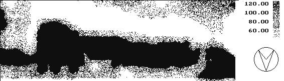
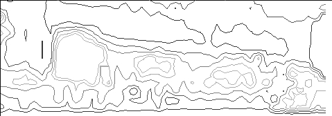 A 15 x 40m grid was laid out over the flat lawn known as Tom Tiddlers Ground with survey points at 1m intervals. Christian Allen compiled the results, (figure 1) shows a dot-density plot of the data. The plot strongly indicates a long linear structure across the northern half of the area. This appears to be part of a much larger structure. The contour plot (figure 2) shows that the structure has clearly defined edges, which implies that this is possibly a wall, its foundation, or similar construction. Given the strength of these results, the feature found is possibly a wall, or similar, belonging to a much larger structure. This implies that these may be part of the remains of the Tudor manor house that was previously situated in the grounds of the current Myddelton House. (See the results on page 2).
After the earlier site visit to Myddelton House the team were shown around a current excavation being carried out by the Enfield Archaeological Society elsewhere. The site to the south of the town near the A10 was in a small back garden but was turning up big results in the form of Roman finds pottery etc as well as post holes and gullies. The area is thought to be a possible farm perhaps near-to or adjacent to a Roman posting-station positioned on Ermine Street now followed by the line of the A10.
Note: From January 2002 Newsletter (Number 370).