Category

Volume 10: 2015 – 2019‎

Newsletter-547-October-2016 – HADAS Newsletter Archive

By | Past Newsletters, Volume 10: 2015 - 2019‎ | No Comments

No. 547 OCTOBER 2016 Edited by Vicki Baldwin

HADAS DIARY

Lectures start at 7.45 for 8.00pm in the Drawing Room, Avenue House, 17 East End Road, Finchley
N3 3QE. Buses 82, 143, 326 & 460 pass close by, and it is five to ten minutes’ walk from Finchley Central Station (Northern Line). Tea/coffee and biscuits follow the talk.

Tuesday 11th October 2016: Women in Medieval London by Professor Caroline Barron

Tuesday 8th November 2016: The Cheapside Hoard by Hazel Forsyth

Tuesday 10th January 2017: My Uncle, the Battle of Britain, VC by James Nicolson

Tuesday 14th February 2017: London Ceramics at time of the Great Fire by Jacqui Pearce

Tuesday 14th March 2017: Bugging the Nazis in WW2: Trent Park’s Secret History. by Helen Fry

Tuesday 11th April 2017: to be confirmed

Tuesday 9th May 2017: to be confirmed

Tuesday 13th June 2017: ANNUAL GENERAL MEETING

Tuesday 10th October 2017: The Curtain Playhouse excavations by Heather Knight MOLA

Tuesday 14th November 2017: The Battle of Barnet Project by Sam Wilson

New Tours of the WCEC at the British Museum. Audrey Hooson

The British Museum has now started offering free tours of the World Conservation and Exhibition Centre to the public. They are on the last Tuesday of each month in the afternoon with four 80 minute sessions available and need to be booked in advance.

A different department will be featured each month:- 25th October – Western Art on Paper

29th November – Eastern Art on Paper and Silk (Hirayama Studio)

13th December – Ceramics, Glass and Metals. I have done this tour and it is very interesting.

For more information see the Events calendar on the BM web site. To book email volunteers@britishmuseum.org.

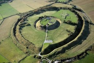
Hendon Open Day Don Cooper

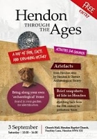
HADAS was very well represented at the Hendon Open Day that took place at the Hendon Baptist Church in Finchley Lane/First Avenue. The event took place on 3rd September 2016.

The event was instigated by Pastor Errol Jacobs in discussion with Jacqui Pearce, a pottery specialist, from the Museum of London Archaeology. HADAS were asked to participate. The format of the day was short presentations of the history of Hendon through the ages, illustrated by slides and photos of old postcards. Each presentation was about twenty minutes long Jacqui Pearce gave almost all of the presentation and there were individual presentations one each by Vicki Baldwin and Don Cooper.

HADAS set up tables with artefacts from the various digs in Hendon done by HADAS members as well as finds from excavations in the London Borough of Barnet, notably the Moxon collection from the Brockley Hill Roman pottery. We also displayed some of our books and publications.

Memories, the shop at 130-132 Brent Street, also displayed old photos, postcards and maps from their collection.

Refreshments were provided by the Church. There were tours of the Church by Mike who told us all about the fascinating history of the Hendon Baptist Church which was built in the 1880s.

Whilst it would have been good if more visitors had come along to this excellent event, those who came thoroughly enjoyed it. Thanks go to Rev Errol Jacobs for the use of the hall, Jacqui Pearce for her organisation and excellent presentations, to “Memories” for the loan of their collections of photos etc. and also to the HADAS crew led by Bill Bass who put it all together.

Hendon Baptist Church Peter Pickering
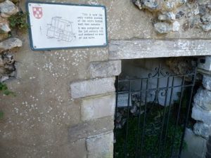
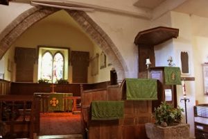
The day was held in Hendon Baptist Church Hall, which is the basement of the church; there are pillars which run through the basement and church up to the roof. Mike told us something of the history of the Baptist denomination in Hendon, and the building of the church, and took a tour round it. It is an aisled cruciform building erected in 1883; it was designed by J. E. Sears in an individualistic version of 13th-century Gothic. Mr Sears was a qualified architect member of the congregation, and had an interesting career as a politician; he was a Progressive member of the London County Council, and from 1906 to 1910 Liberal Member of Parliament for Cheltenham. But I have not been able to find any more buildings that he designed.

The church is obviously well-used and cared-for, and did not seem to have suffered from the re-orderings that can obscure original features; the roof was particularly fine. To those of us more used to Anglican churches there were strange as well as familiar features. No pictorial glass in the windows, for instance. Baptists practise baptism of adults, by total immersion, and at what I thought of as the east end, besides a pulpit and a communion table there is a trough in which baptisms take place. (Unfortunately, it was covered over when we were there, but the trapdoor above it is to be seen.) The organ has pride of place, and we were shown the pumping handle by which it used to be powered (and still can be if the electricity fails). The church is on a sloping and elevated site; there is a lift so that the less agile do not have to climb the many steps.

Remembering 1916 – in South Croydon Stewart Wild

I recently visited an excellent World War I exhibition at a school in South Croydon, just off the Brighton Road. It was due to end on 31 August, but due to its success it has been extended well into next year, in fact to 16 April 2017.

The exhibition is located in a hall in the grounds of Whitgift School and is the brainchild of headmaster Dr Christopher Barnett, who gained his doctorate in history among the dreaming spires of Oxford. It took him and his team of trustees, staff and pupils three years to gather a remarkable collection of WWI artefacts from a number of museums and private collections, and to build the exhibition panels and displays on the school premises.

The results are spectacular. All the might and wealth of the Imperial War Museum could not have done better. And to cap it all, they have created a splendid and authentic Edwardian cafe for visitors to relax in, complete with period decoration and furniture.

It took me nearly three hours to see it all, after which I was in need of an Edwardian sandwich and cup of tea. You begin with displays of 1914 recruiting posters and enlistment, after which the accent is firmly on 1916, the year of the terrible carnage on the Somme, the Battle of Jutland, the death of Lord Kitchener and the appalling loss of life at Gallipoli and Verdun.
It was also the year of the Zeppelin airships, the first aerial bombardment of London, and the heroism of Lt William Leefe Robinson, who won the V.C. for being the first to shoot one down.

The exhibition is not in any way triumphalist, and Dr Barnett has gone to great lengths to include French and German voices too, using excerpts from letters, diaries and memoirs. Throughout you are reminded that this is a giant history lesson too.

The team has built several realistic dioramas, not only of front-line tunnels and trenches, but also of an Edwardian parlour on the home front as a reminder of the awful unwanted telegrams that were delivered to grieving households all over the country.

One especially interesting item I found was a postcard from somewhere in France addressed to Mrs W R Wilkes, 21 Highwood Avenue, North Finchley, London N. Dated 19.4.16, the message began “Dear Ma and Pa” and complained mainly about the weather. Unfortunately their son’s name was not legible.

Among the displays of guns, grenades, bayonets, knives and even a knuckleduster, there’s also a range of things the poor Tommies treasured most: soap, foot powder, tobacco and letters from home.

A century-old Sunbeam bicycle and a Triumph motorcycle can be examined in detail. Bruce Bairnsfather’s books and renowned ‘Old Bill’ cartoons bring a touch of light relief.

There are two flags from the Battle of Jutland, an ensign from the British light cruiser Southampton and one from the German battleship Von der Tann. In contrast is an unpublished diary account of what happened as the battle began on 30 May 1916 by a crew member of HMS Inconstant, presumably written with Stephens’ famous blue-black writing fluid since the handwriting hasn’t faded.

The summer of 1916 was also when the Royal Flying Corps first crossed swords with German flying ace Manfred von Richthofen, the ‘Red Baron’. The exhibition features a lot about this legendary character since his first victim, in September 1916, was an Old Whitgiftian named Lionel Morris.

By an extraordinary quirk of fate, it was also an Old Whitgiftian who performed the autopsy on the Red Baron when he was finally shot down over Amiens two years later. Imaginative displays tell the whole story.
The exhibition is open daily, 10am to 5pm and there is free parking on site. Alternatively, the Whitgift Exhibition Centre is ten minutes’ easy walk from South Croydon station.

Further information: www.remembering1916.co.uk

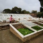
Glasshouses Vicki Baldwin

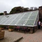
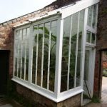
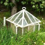
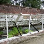
During a recent visit to Heligan in Cornwall I was struck by the variety of structures that fall under the description ‘glasshouse’ and how they were adapted to fit situation and purpose. There were coldframes, lean-tos, full height, half-height, the ‘pineapple pit’ utilising horse manure to produce heat, and portable single plant covers. They were built into corners and against south-facing walls to maximise warmth. Access was by door, sliding panel, hinged window or, in the case of the very small examples, removable top.

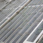
These glasshouses not only enabled the gardeners to produced food all year round, but also allowed for experimentation and the growing of more exotic species such as melons (each hanging in its own net for support) and the highly desirable pineapple. In addition, the Flower Garden has the Orchid House and “possibly the last remaining Paxton House in Britain” (Heligan Centenary Guide Book, updated 2016). Apart from the small, portable example, all these structures are supported on low, brick walls to raise the wooden parts above the ground. In many cases “beaver tail” glazing was used to divert rainwater away from the vulnerable wooden frames. This is visible in the pictures below.

As mentioned, the heat produced by decomposing horse manure was one method of regulating optimum growing conditions. Later, coal fired boilers were installed in the houses, and keeping them stoked become an additional task. The boilers varied in shape and size, and a Horseshoe Boiler can be seen behind the Melon House.

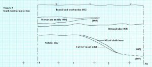
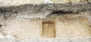
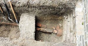
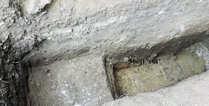
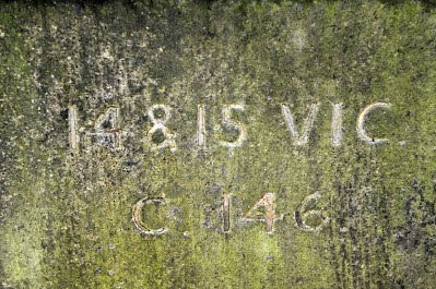
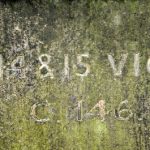
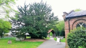
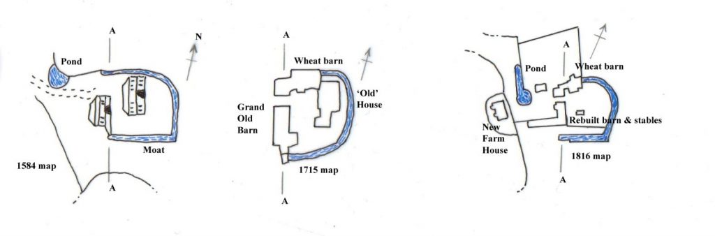
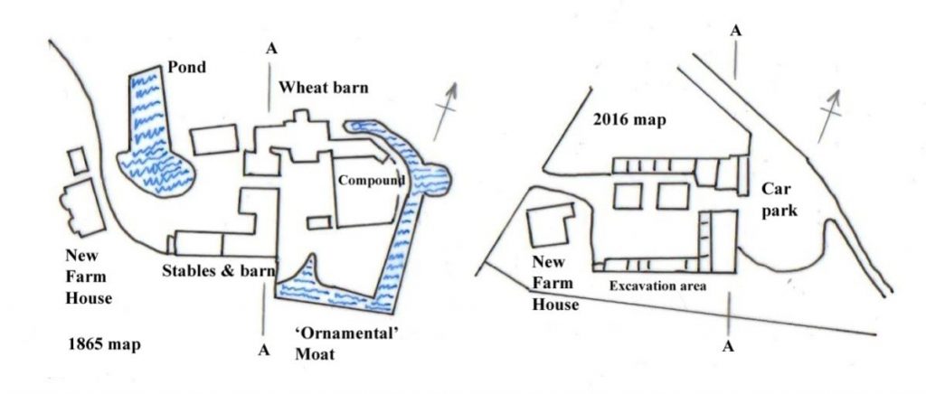
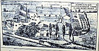
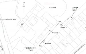
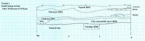
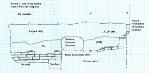
All very interesting, but what is the relevance? Well, the area we have excavated in the grounds of Avenue House in 2014 and 2015 is shown as glasshouses on a map of 1894-1896. In addition, a visitor to the house mentions passing the glasshouses on the drive. Until I visited Heligan, I had not fully realised the possible diversity of the structures we were investigating. We know that there was an extensive water management system in the grounds of Avenue House, indeed we discovered a large cistern below the structure we were excavating in 2015. However, although we can uncover the footprint of the glasshouses, without any photographs or pictures we can only guess at the form of the superstructure.

1.’Lean-to’; 2. Beavertail glazing; 3 & 4. Various low frames; 5. Portable structure with removable top; 6. Banana House.

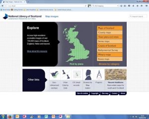
National Library of Scotland – A mapping resource for HADAS

Roger Chapman

You might not think that the National Library of Scotland would be a good place to look for mapping resources for Barnet but currently I know of no better for historical map research of our area. The National Library of Scotland has over 150,000 high resolution historic map images. Naturally the focus is on Scotland but the collection includes detailed Ordnance Survey map series of England and Wales. It is also a collection that is growing and is worthwhile going back to from time to time. One of the features that I particularly like about this collection is the ability it gives to look at historical maps superimposed on to modern satellite photographs or mapping.

This article aims to explain how to go about this in a simple and straightforward manner. It will certainly give you hours of enjoyment on wet winter days looking at the changes that have taken place over the past 100 – 150 years in our local area – or indeed anywhere else in the UK that may interest you.

Step One:

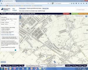
Google “National Library of Scotland” and follow the link or type www.maps.nls.uk into your web browser.

You should then be looking at the screen below.
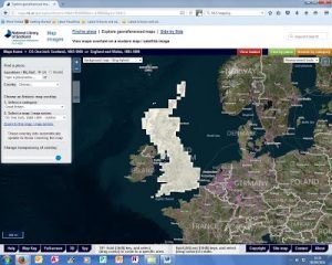
Step Two:

At the bottom of the page, adjacent to “Other links” you will see a light blue box entitled “Georeferenced overlays”. Click on this and you will be taken to the page below.

Step Three:
In the light blue box to the top left of the screen type the place you are looking to find in the box that says “Type a place-name” In the example below I typed “Finchley “ which the programme decided should be changed to “London UK” but it worked and took me to the Finchley area. That is often enough but you can also select the county if you wish. Oddly the Parish drop down box doesn’t include Finchley or Hendon at the moment.

Step Four:

You also need to “choose an historic map overlay” from the light blue box above. In 1. Select a category. I chose “England and Wales” from the drop box by clicking the arrow on the right hand side. In 2. “Select a map/map series” I chose “OS 25 inch 1890’2-1920’s [Note that the coverage for historic map layers may not yet be complete so some overlays may not be available at the moment.]

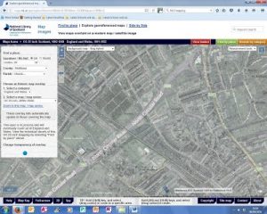
The area that you have chosen and the historic map layer should now show up as in the image below.

Step Five:
At the bottom of the box headed “Find a place” is a blue button under the heading “Change transparency of overlay” Toggle this to the left and the historic map begins to be shown against a modern satellite photograph. You can use this to increase or decrease the transparency of the overlay/satellite map. See next image below.

Step Six:

Near the top of the map is a white horizontal box with the text “Background map – Bing hybrid” This is the Background map which shows above. Use the dropdown box to find other options for background maps and see which one works for you.

Other things to do:

There are many other options to play around with. Use the + and – buttons near the top of the page to zoom in to areas you wish to examine in detail. The slider symbol under the + and – signs performs the same function.

You can also use the measurement tool box (towards the top right hand side of the screen) to measure the distance between two objects or to measure areas of buildings, fields or whatever takes your fancy.

There is plenty of scope and a lot of fun to be had with this amazing online resource. Currently I am using it to identify old demolished buildings in Finchley and finding out if they are on publicly accessible sites for future possible HADAS excavations. It is also incredibly useful to look at sites where planning applications are being proposed to see what, if anything, existed on the site beforehand.

***PLEASE NOTE***

‘Hertfordshire at War’ Annual Symposium
Saturday 12th November: 10.00am – 4.30pm, Herts Association for Local History, Ewen Hall, Wood Street, Barnet EN5 4BW

Full details and cost in ‘Other Societies Events’ section below

Other Societies’ Events Eric Morgan

Tuesday 4th October: 3pm, Finchley Society. 5 Graywood Court, N12.
Joseph Grimaldi Blue Plaque & Information Panel Unveiling Ceremony. Griff Rhys Jones, will unveil the plaque. The information panel, designed by Peter Marsh (Hadas Member), will also be unveiled in the grounds of Finchley Memorial Hospital. Griff is President of Civic Voice.

Monday 10th October: 2.30 for 3.00pm, Barnet & Local History Society, Church House, Wood St, Barnet, (opposite museum). The development of The English Country House: medieval to 20thC. Talk by Pamela Wright. Visitors £2. Also Wednesday 23rd November, 8pm, AGM.

Saturday 22nd October: 9.45am – 4.30pm, Enfield Society, Jubilee Hall, 2 Parsonage
Lane/junction Chase Side, Enfield EN2 0AJ. Day Conference – The changing face of Local History

– Edmonton Hundred History Society 80th Anniversary. For more details please visit www.edmontonhundred.org.uk

Thursday 27th October: 8.00pm, Finchley Society, Drawing Room, Avenue House, East End Road N3 3QE. Air Pollution & Victoria Park. These are 2 topics for the discussion meeting mentioned in the HADAS Sept Newsletter. The Air Pollution Survey of North London results will be given by Chris Church. The Victoria Park Projects update will be given by someone from Barnet Council. Visitors £2. Also Thursday 24th November 8pm Footsteps of the Famous. Jean Scott Memorial Lecture by Paul Baker.

Thursday 27th October: 7.30pm, Camden History Society, Burgh House, New End Square, NW3
1LT. ‘When Sigismund Came to Dine’, Prof Lester Hillman on an event that occurred 600 years ago in Kentish Town with William Bruges 1st Garter King of Arms. Sigismund became Holy Roman Emperor (1433-7).

Monday 31st October: 5.30pm, LAMAS. Spooky tour of Spitalfields Medieval Charnel House. Led by Jane Sidell (Inspector of Ancient Monuments) including a short talk. Meet outside Ca Restaurant,

corner of Spital Square, EC2. Non-members £5 on the night, book by email

Jane.Sidell@btinternet.com or write to Jane Sidell, 113, Lion Lane, Haslemere, Surrey.

Tuesday 1st November: 7.30pm, Enfield Society, Jubilee Hall, 2 Parsonage Lane/junction Chase Side, Enfield EN2 0AJ. Presenting Enfield – A Spoon Full of Sugar, talk by Joe Studman on the development of the of the health service in Enfield from folk remedies to North Middlx Hospital.

Wednesday 2nd November: 6pm, Gresham College at The Museum of London, 150 London Wall EC2Y 5HN. Saving the Twentieth Century. Talk by Dr Simon Thurley, free, on most threatened buildings in Britain built in the 20thC.

Thursday 3rd November: 8.00pm, Pinner Local History Society, Village Hall, Chapel Lane Car
Park, Pinner. Elspeth McClelland and Pinner’s Suffragettes, talk by Thamar Maltver.

Visitors £3. Also Thursday 6th Oct, 8pm, Elizabeth Rogers of Eastcote House: An 18thC Lady of Property, talk by Eileen Bowlt (LAMAS).

Saturday 5th November: 10.30am – 4.30pm, G. A Festival of Geology, UCL, Gower Street, WC1E
6BT. Displays by Geologists’ Association Members and Affiliated Societies (Amateur Geological Society will have a stand there). Sales of fossils & minerals, books, maps and geological equipment, amateur photographic competition, geological talks & walks, free entrance.

Wednesday 9th November: 2.30pm: Mill Hill Historical Society, Trinity Church, The Broadway, NW7. Daily life in Verulamium, talk by David Thorold.

Wednesday 9th November: 7.45pm, Hornsey Historical Society, Union Church Hall, Corner of Ferme Park Rd/Weston Park, N8 7PX. Darling Daisy, talk by Dr Neil Houghton. Visitors £2, refreshments, sales and info from 7.30pm. Also Wednesday 12th October, 7.45pm, The Great Fire of London, talk by Marianne Zieran.

Friday 11th November: 7.45pm, Enfield Archaeological Society, Jubilee Hall, 2 Parsonage
Lane/junction Chase Side, Enfield EN2 0AJ. Roman Pottery Making in Highgate Wood Archaeology & Experiment. Presidential Address given by Harvey Sheldon (also HADAS President). Visitors £1, refreshments, sales and info from 7.30pm.

Saturday 12th November: 10.00am – 4.30pm, Herts Association for Local History, Ewen Hall, Wood

Street, Barnet EN5 4BW. ‘Hertfordshire at War’ Annual Symposium, including The Battle of

Barnet Project, The Second Battle of St Albans, How the Civil War Affected Herts 1642-1652, The

Home Front During WWI, Salisbury Hall & The De Haviland Aircraft Co. Tickets non-members £15 (£12 HALH members). Hot lunch available if booked in advance, £10. To order tickets please visit www.stalbanshistory.org. For further details see www.halh.org.uk or contact Ruth Jeavons, 44, Necton Road, Wheathampstead, Al4 8AU. Tel 01582 629516.

Saturday 12th November: Enfield Society, Dugdale Centre, Enfield Museum, 39 London Road, Enfield EN2 6DS. ‘Enfield The Time of Change’ Day Conference on Enfield in the last century, including talks on the history of Enfield by Monica Smith, Enfield in WWI by Ian Jones (including a walk around Enfield Town looking at buildings the society has helped to save over the past 80 years led by Joe Studman and Dave Cockle. Also other activities in the museum. Cost (to include lunch, coffee & tea) is £15. To book a ticket please send name & telephone no. & include a SAE and cheque payable to The Enfield Society to Conference, Jubilee Hall, 2 Parsonage Lane/junction Chase Side, Enfield EN2 0AJ. Or try to book at www.enfieldsociety.org.uk/conference by card or PayPal.

Wednesday 16th November: 2.30pm, Edmonton Hundred History Society, Jubilee Hall, 2 Parsonage Lane/junction Chase Side, Enfield EN2 0AJ. Another Kind of Life: Dickens and the Theatre, talk by Dr. Tony Williams, visitors £1.

Thursday 17th November: 7.30pm, Camden History Society, Camden Local Studies and Archive Centre, 2nd Floor, Holborn Library, 32 Theobalds Road. Filmed in Camden, talk by Danny Nissim, visitors £1.

Friday 18th November: 7 pm, Fri 21st Jan: 7.30pm, CoLAS, St Olave’s Parish Hall, Mark Lane, EC3. Discoveries at Happisburgh, talk by Dr Nick Ashton.

Saturday 19th November: 10.30am – 6pm, Weston Theatre Museum of London, 150 London Wall,
EC2Y 5HN. LAMAS Local History Conference: ‘Walking Through London’s History’. Tickets £12.50 before 31st October or £15 from 1st November. Include a SAE and cheque payable to LAMAS or PayPal via www.lamas.org.uk/conferences/local-history.

Wednesday 23rd November: 7.45pm, Friern Barnet & District Local History Society, North Middlx
Golf Club, The Manor House, Friern Barnet Lane, N20 0NL. ‘Upstairs at the Gatehouse – Highgate’s Theatre’, talk by John Plews, visitors £2.

Saturday 26th November: 10.00am – 3pm, Trinity Church, 15 Nether Street, N12 7NN. Amateur Geological Society’s Mineral, Gem and Fossil Show. Including rocks, books, crystals, gemstones and jewellery. Refreshments, admission £2, please note new time and venue.

Newsletter-546-September-2016 – HADAS Newsletter Archive

By | Past Newsletters, Volume 10: 2015 - 2019‎ | No Comments

No. 546 September 2016 Edited by: Sandra Claggett

HADAS DIARY 2016/17

Saturday 3rd September 10am to 4pm. HADAS Open Day. Hendon Baptist Church Hall, Finchley Lane, Hendon NW4 1DJ. Display of artefacts from Hendon sites & a series of brief snapshots of life in Hendon. FREE including refreshments.
Monday 19th to Friday 23rd September: Trip to Bradford-on-Avon.
Tuesday 11th October @ 8pm: Women in Medieval London. Lecture by Professor Caroline Barron.
Tuesday 8th November @ 8pm: The Cheapside Hoard. Lecture by Hazel Forsyth.
Tuesday 10th January @ 8pm: My Uncle, the Battle of Britain VC. Lecture by James Nicolson.
Tuesday 14th February @ 8pm: To be confirmed.
Tuesday 14th March @ 8pm: Bugging the Nazis in WW2: Trent Park’s Secret History. Lecture by Helen Fry.

All Lectures are held at Stephens House & Gardens (Avenue House), 17 East End Road, Finchley, N3 3QE, and start promptly at 8.00 pm, with coffee /tea and biscuits afterwards. Non-members welcome (£1.00). Buses 82, 125, 143, 326 & 460 pass nearby and Finchley Central Station (Northern line) is a short walk away.

Mesolithic Hunters and Gatherers of West Heath, Hampstead: Time, Landscape and Place by Melvyn Dresner
As part of my Masters in Archaeological Practice at Birkbeck College, I am examining what life was like in the Mesolithic past in North London based on evidence collected by HADAS members and stored in the LAARC – London Archaeological Archive and Research Centre. Around 11,000 years ago, people lived on the high ground at West Heath, Hampstead, hunting red deer, living off other forest resources such as hazelnuts, hunting or cohabitating with beavers, and eating the occasional odd swan.

West Heath, Hampstead was dug by HADAS members in the 1970s and 1980s and published
1989. Much of the analysis was based on spatial patterning and tool typology. I’m working through this analysis of lithic tools to see if there is evidence for duration of occupation and comparing postholes found there with similar finds at Howick, Northumbria, and Star Carr, Yorkshire, where dwellings have been interpreted and reconstructed experimentally, as well as faunal evidence at Three Ways Wharf, on the River Colne, where red deer, swan and beaver were found.
At that time the Thames was a tributary of the Rhine and the southern North Sea was land where people lived. We know about these people mainly from the stone tools they made, including micro-lithic tools, serrated edges, and axes – these and other tools point not only to hunting but also working skins (scrapers), tailoring by sewing skins together (piercers), wood and bone working (burin, axes, serrates and saws) as well as hafting pointing toward use of twine/adhesive. We term these people as Mesolithic based on micro-lithic and axe technology and relationship with the Boreal/Atlantic forest – a period that lasted more than 4,000 years. West Heath can be dated to this early period when birch forest was being replaced by hazel and oak.

Work by Bryony Coles in France on beavers’ re-colonisation suggests how we can consider beavers during the Mesolithic in Britain making the environment desirable by building dams in places such as West Heath – holding nutrients on higher ground, attracting water fowl, fish, as well as grazing animals (red deer) and their predators such as wolf and people. Recent publications add to the picture of Mesolithic wood-working; bone and wood was mainly lost at West Heath due to the acidic soil. Through strontium isotope analysis (- Langford, Essex – first time used on human remains from this period in Britain, published earlier this year in the Mesolithic Miscellany, June 2016) it seems to show people are more attached to place and spend their life on limited geology.

The people of West Heath are likely to be highly mobile though the lithic scatters relate to postholes in plan and depth suggests people were here over a long period in two or three phases. Over 61,000 lithic items were found at West Heath, including over 800 identified tools. I’m only using a small sample to investigate this aspect in three trenches (still more than 2,000 lithic artefacts), learning about people who lived locally 11,000 years ago from evidence collected 40 years ago.

Selected Bibliography

Coralie Acheson (Archaeology) James Dixon, Charlotte Bossick (Built Heritage), Juan Jose Fuldain,
Carlos Lemos (Graphics), Museum of London Archaeology (MOLA), HAMPSTEAD HEATH, London Borough of Camden Historic Environment Assessment, June 2013

Archaeological Research Services Ltd (2012) Howick Project [dataset]. York: Archaeology Data
Service [distributor] (doi:10.5284/1017454)

Bryony Coles 2006, Beavers in Britain’s Past, Oxbow Books and WARP

Desmond Collins and Daphne Lorimer, Excavations at the Mesolithic Site on West Heath, Hampstead 1976 – 1980, Hendon and District Archaeological Society, BAR British Series 217, 1989

John S C Lewis, with James Rackham 2011, Three Ways Wharf, Uxbridge: A Late Glacial and Early Holocene hunter-gatherer site in the Colne valley, Museum of London Archaeology

S Maroo and DW Yalden 2000, The Mesolithic mammal fauna of Britain, Mammal Review 30, 243– 248.

Sara A. Rich, Ryan Watts and Garry Momber, Mesolithic woodworking, experimental archaeology & underwater heritage in Hampshire and the Isle of Wight (UK), Mesolithic Miscellany, Volume 24: Number 1, June 2016

Rick Schulting, Christophe Snoeck, Louise Loe, Nick Gilmour, Strontium isotope analysis of the
Mesolithic cremation from Langford, Essex, England, Mesolithic Miscellany, Volume 24: Number 1, June 2016

^^^^^^^^^^^^^^^^^^^^^^^^^^^^^^^^^^^^^^^^^^^^^^^^^^^^^^^^^^^^^^^^^^^^^^^^^^^^^^^^^^

Simon Williams writes a response to the “The Great Stink / The Cholera / Bazalgette lecture, London, 1858” article written by Stewart Wild in August’s Newsletter

The following gives an eye-witness account of this aspect of London, in the form of Jacob’s Island, a rookery situated straddling the Thames at Bermondsey, just east of St.
Saviour’s Dock / The River Neckinger. It was Fagin’s Den in Oliver Twist, with Sikes & Nancy. Chapter 50: “inhabitants on either side lower from their back doors & windows, buckets, pails, domestic utensils of all kinds, in which to haul the water up …. & when the eye is turned from these operations to the houses themselves, utmost astonishment will be excited from the scene before him. Crazy wood galleries common to backs of half-a-dozen houses, with holes from which to look upon the slime beneath; windows, broken & patched ……. Chambers thrusting out above the mud, & threatening to fall into it, as some have before ……”

Mayhew’s London Characters (information gathered in 1867) describes it as a pest-nest: “against the posts of the bridges, were swollen carcases of dead animals ready to burst. At the back of every house were pig-sties…. One of the inmates replied ” Neither I nor my children know what health is”. If another inmate put his hand against the wall behind him, it would be covered by the soil of his neighbours privy, sopping through the wall …. Its inhabitants were wont to leave the murky hauled liquid to stand, so that they might after it had been left to settle for a day or two skim the fluid from the solid particles of filth & pollution which constituted the sediment…..Each epidemic of: typhoid, cholera, typhus, influenza, & scarletina came back summer after summer.” These dwellings were rented.

It might be a surprise that these conditions persisted even after the introduction of clean piped water & sewers legislation, but that didn’t apply to the poorest!

NB Simon plans to bring us more on ‘Mayhew’s London Characters’, in the next Newsletter

Hadrian’s Wall: Life on Rome’s northern frontier. Lecture by Matthew Symonds on 10th May 2016 Sue Willetts

This was a fascinating and well-illustrated talk by the editor of Current Archaeology who has a long-standing interest in, and enthusiasm for, the study of Hadrian’s Wall. The traditional concentration on structures and their military aspects has obscured the archaeological potential of this frontier zone and the complex relationship between an imperial state and local tribal groups. Some have seen the wall as a way to control movements and communications in a largely peaceful environment – a type of customs barrier – while others have emphasised the defensive function due to a genuine military threat. The brief mention in the classical sources that Hadrian ‘was the first to construct a wall, eighty miles in length, which was to separate the barbarians from the Romans’ [1] has been and still is the subject of much debate. Matthew set the scene by showing an atmospheric reconstruction painting (by Alan Sorrell) of a fort on the wall and mentioned modern structures such as The Berlin Wall for comparative purposes.

The wall was originally planned to be 76 Roman miles running from Newcastle to Bownesson-Solway on the Cumbrian coast and constructed to take advantage of the higher ground to the north of the Stanegate – a road which linked the Tyne and the Solway. The wall was later extended to Wallsend on the east to make a length of 80 Roman miles. Hadrian’s Wall may have been ordered by the emperor when he visited the province in AD122 as a response to some major unrest among British tribes c117 AD and it appears that the original plan was to have a wall of stone or turf fronted by a wide and deep ditch with 80 milecastles – a mile apart (in theory) each containing a small group of soldiers. Between each milecastle were 2 evenly spaced small turrets which were watchtowers – lookout posts which could also be used for signalling. But due to the nature of the terrain some structures were placed at more suitable positions. A number of extra forts on the line of the Wall itself were a late addition to the original plan. The wall took at least six years to complete and was built in sections by legionaries but once built was manned by auxiliary units from all over the Empire. Each fort housed a single auxiliary unit with infantry or cavalry soldiers, or both.

Dependent communities of traders and camp followers were established in vici close to the forts such as the one at Vindolanda. These would have housed a mix of locals and people from across the Empire, including retired soldiers and their dependents. Inscriptions show that soldiers and civilians came from as far as Spain, Germany and Syria. We know much about daily life, including a birthday invitation (no. 291) from the wooden writing tablets found in water-logged conditions from this site http://vindolanda.csad.ox.ac.uk

There has been much debate about the purpose of the wall and it is now generally agreed that it acted both as a visible demonstration of Roman power and influence, even more so if, as has been suggested, it was plastered and whitewashed. While the wall did mark a Roman frontier (extended to the north later with the Antonine Wall) it was also to make security checks, controlling the passage of people and goods and where taxes / dues could be collected. A deep ditch known as the vallum to the south was added, still visible in sections today. There is more research to be done on understanding the turf sector at the western end, so too the vallum as well as the civic settlements, Mithraeum and cemeteries which have been revealed by geophysical surveys which will add to our knowledge. So too will further studies on the time after Hadrian as well as on material remains like the “Staffordshire moorlands pan” which names the Wall, as well as inscriptions and writing tablets. In addition, new planning regulations have revealed unknown roads, villas and rural settlements including evidence of roundhouses north of Newcastle allowing further study on the impact of the frontier on the local population, which will add to our knowledge of this important monument.

These links are useful for anyone planning to visit or for further study:
http://hadrianswallcountry.co.uk/
http://www.english-heritage.org.uk/visit/places/hadrians-wall/plan-your-visit
https://www.futurelearn.com/courses/hadrians-wall/ (The speaker contributed to this course)

Correction to earlier newsletters

Tuesday 11th October 2016
Prof Caroline Barron will be speaking on Women in Medieval London for HADAS and not Doctor Caroline Cartwright as listed in the August newsletter.

New course organised by the Mill Hill Archaeology Study Society

For 10 weeks from 7 October 2016, Allan Wilson will be the tutor for a course on
The Western Roman Empire at a cost of £75.00. The Society’s meetings are held on
Fridays 10am – 12.00 at: The Eversfield Centre, Eversfield Gardens, Mill Hill, NW7 2AE

Each session lasts 2 hours, including coffee break. The session style is friendly and informal, combining lectures, visual material and course handouts; debate and discussion are encouraged. If anyone is interested please contact their Secretary for further details:

Secretary: Peter Nicholson, 4 Frinton Court, Byron Road, Mill Hill, NW7 4AE Tel: 020 8959 4757 email: peter@mhass.co.uk

Note for HADAS newsletter from Andrew Selkirk

Many members of the society will know of the resistivity meter which the society uses with great success. This was provided by the Council for Independent Archaeology, which set out to produce a resistivity meter which would be affordable for local societies. Over 100 were produced, but unfortunately production then had to cease due to an EU directive forbidding lead soldering – which was very necessary in producing the actual meter. However Bob Randall, the electronics wizard who produced the meter, has now produced a Mark 2 which is a great upgrade of the whole meter. This features a computer tablet – it will work with any Android tablet – which is attached to the meter and will record the results of the survey as the survey proceeds. This means that the area of the survey can be adapted according to the results.

The meter will receive its first public demonstration at the annual conference of the Council for Independent Archaeology, which will be held at Toddington (Dunstable) – on the 24th September 2016. The venue is in fact at a pioneering venue, the Poplar’s Garden Centre, which is just off the M1 at the Toddington turn-off. They have just added an education centre to their facilities which the CIA is hiring for the day. It should be easily accessible to HADAS members – it is only half a mile off the M1.

A feature of the conference will be the work of the local society. The conference will be held in conjunction with the Ampthill and District Archaeological and Historical Society and will feature the excavations at Ampthill Castle where the society did an extensive geophysical survey in advance of the professional-led excavations — which proved to be something of a fiasco. We will be visiting the site of the excavations as an add-on to the conference on Sunday, 25 September.
Details of the conference can be seen on the CIA website at www.independents.org.uk . Email Keith Foster on skfoster@btinternet.com to make a booking.

Further details from Andrew Selkirk – andrew@archaeology.co.uk

Bob displays tablet.

Details of other societies’ events by Eric Morgan
Saturday 17th September. Barnet Museum and Local History Society. Coach outing to Rochester. For details please contact Dennis Bird at 87 Hadley Highstone, Barnet, EN5 4QQ.
Telephone 0208 449 0705 or Barnet Museum on 020 8440 8066. Email: enquiries@barnetmuseum.org.uk. Cost £16.

Saturday 1st October, 10am-4.30pm. St Albans Archaeological Research and resolve group. Verulamium Museum, St Michael’s Road, St Albans. Archaeology in and around St Albans, past and present. A conference in conjunction with St Albans and Herts Architectural and Archaeological Society. Please see the website http://www.stalbanshistory.org for details. £10 (£7 Conc.)

Tuesday 4th October, 7.30pm. Enfield Society. Jubilee Hall, 2 Parsonage Lane, Enfield, EN2 0AJ. Preserving Enfield, cultivated residents. Talk by Joe Studman. £3.

Monday 10th October, 1pm. Gresham College at Museum of London, 150 London Wall, EC2Y 5HN. This and the next 3 Gresham talks are FREE. The early river Thames: The Iron Age and before by Jon Cotton.

Friday 14th October, 7.45pm. Enfield Archaeology Society. Jubilee Hall, 2 Parsonage Lane, Enfield, EN2 0AJ. Verulamium revealed, Kris Lookyear.

Friday 14th October to Sunday the 16th of October. Conference at Royal armouries at the Tower of London, 1066: interpreting the Norman Conquest. Contact bookings at bookings@armouries.org.uk or tel. 0113 230 1888.

Monday 17th October, 1pm. Gresham College at Museum of London. The growth of London as a port from Roman to Medieval times. Gustav Milne.

Wednesday 19th October, 7.30pm. Willesden Local History Society. St Mary’s Church Hall, Neasden lane, NW10 2TS. Clitterhouse Farm. Roger Chapman (HADAS) on the latest information.

Friday 21st October, 7pm. COLAS. St Olave’s Parish Hall, Mark Lane, EC2R 7LQ.
Quarrying and selective deposition in Roman Ewell. Alexis Haslam (P.C.A) Visitors £2.

Friday 21st October, 7.30pm. Wembley History Society, English Martyrs Hall, Chalkhill Rd, Wembley HA9 9EW (top of Blackbird Hill). Cutting edge. Lester Hillman on the 200th anniversary of the opening of the Regents Canal. Visitors £3. Refreshments 50p.

Monday 24th October, 1pm. Gresham College at Museum of London. From sail to steam: London’s role in a shipbuilding revolution. Elliott Wragg.

Wednesday 26th October, 7.45pm. Friern Barney and District Local History Society. North Middx Golf Club, the Manor House, Friern Barnet Lane, N20 OWL. Queens of Henry the VIII. Gary Fisher. Visitors £2.

Thursday 27th October, 8pm. Finchley Society. Drawing room, Avenue House, East End Road, N3 3QE.Discussion meeting. For further details please see their Sept/Oct Newsletter. Visitors £2.

Monday 31st October, 1pm. Gresham College at Museum of London. The port of London and its future. Doctor Riggs.

Newsletter-545-August-2016 – HADAS Newsletter Archive

By | Past Newsletters, Volume 10: 2015 - 2019‎ | No Comments

No. 545 AUGUST 2016 Edited by Stephen Brunning

HADAS DIARY 2016/17

Saturday 3rd September 10am to 4pm. HADAS Open Day. Hendon Baptist Church Hall, Finchley Lane, Hendon NW4 1DJ. Display of artefacts from Hendon sites & a series of brief snapshots of life in Hendon. FREE including refreshments.

Monday 19th to Friday 23rd September: Trip to Bradford-on-Avon.

Tuesday 11th October @ 8pm: Women in Medieval London. Lecture by Dr Caroline Cartwright.

Tuesday 8th November @ 8pm: The Cheapside Hoard. Lecture by Hazel Forsyth.

Tuesday 10th January @8pm: My uncle, the Battle of Britain VC. Lecture by James Nicolson.

Tuesday 14th February @8pm: To Be Confirmed.

Tuesday 14h March @8pm: Bugging the Nazis in WW2: Trent Park’s Secret History. Lecture by Helen Fry.

All Lectures are held at Stephens House & Gardens (Avenue House), 17 East End Road, Finchley, N3 3QE, and start promptly at 8.00 pm, with coffee /tea and biscuits afterwards. Non-members welcome (£1.00). Buses 82, 125, 143, 326 & 460 pass nearby and Finchley Central Station (Northern line) is a short walk away.

Free University on-line courses (at FutureLearn):
HADRIAN’S WALL – starting 7th November. Enrolling now.
EXPLORING ENGLISH: MAGNA CARTA (started 18th July).
HOMO FLORESIENSIS UNCOVERED: THE SCIENCE OF ‘THE HOBBIT’ (started 18th July).

Plus many more……….

Altogether there are over 50 courses from Family History to Climate Change, plus a couple on Shakespeare. All are on-line & free. All the material is provided; no books to buy/ read, essays or exams. Learning is by dialogue with tutors/other students. All the material is accessible on-line (once enrolled) at any stage, so it’s easy to join late, & catch up if necessary.

An unexpected interesting by-product with these courses is the chance to converse with fellow students/ enthusiasts located literally all over the planet!
https://www.futurelearn.com

British Archaeological Awards winners announced at the British Museum in July

Historian Bettany Hughes and archaeologist Julian Richards presented awards to some of the UK’s leading archaeologists, showcasing new discoveries up and down the country that are transforming our understanding of Britain’s past.

The 2016 winners reflect the rich diversity of archaeology across the UK, from the industrial archaeology of the Welsh Slate industry, winner of ‘Best Book’, to the major discoveries being unearthed Under London and in Cambridgeshire at Must Farm, which was awarded ‘Best Discovery’ for reshaping our knowledge of the British Bronze Age.

In a presentation about his Highly Commended Stonehenge book, Mike Parker Pearson reflected on the British public’s increasing fascination with the distant past, fuelled by technological advances, archaeological innovation and new knowledge.

Sharing the excavation with the public was central to Oxford Archaeology South’s winning Westgate project
– the largest ever archaeological site in Oxford, while enabling readers to examine the unique Mesolithic Star Carr pendant for themselves using digital publishing technologies was the focus of the Postglacial project’s electronic article in Internet Archaeology.

Community engagement and passion for their shared past shone through the Battles, Bricks and Bridges project, which brought together archaeology and reminiscing to identify a previously disputed battlefield site in County Fermanagh and restore a seventeenth-century bridge, turning villagers’ memories of history and culture into heritage for future generations.

The excavator of Danebury Hill Fort, the Sacred Spring in Bath and Fishbourne Roman Palace, Professor Sir Barry Cunliffe CBE, was recognised for his own exceptional contribution to our understanding of the past with an Award for Outstanding Achievement. In an inspiring acceptance speech, Barry called archaeology “a family”, saying that archaeologists all shared the desire to communicate their knowledge and were “creative, vital and inclusive”.

DCMS Heritage Minister, Tracey Crouch presented the Best Community Engagement Award, commenting:
“Archaeology is such an important part of our nation’s heritage, helping us understand our culture and how people lived in the past.”.

The Great Stink, London, 1858 Stewart Wild

It’s difficult to imagine living conditions in London 160 years ago, when overcrowded cities were unhealthy places to live, disease was rife and the stench of horse manure and human waste was pervasive.

Deaths from sickness were at a level not seen since the Black Death. In London, with a population of three million, the problem was becoming a crisis. Thousands of homes still had stinking cesspits beneath them and in the poorest areas this vile effluent oozed up through the floorboards.

In 1847 the newly formed Metropolitan Commission of Sewers took action, banning all cesspits and stating that all privy refuse should be discharged in the sewers. This added to the waste from the water closets which had recently become popular among the city’s richer residents.

However the sewers were little more than storm drains and so the new law simply meant that all human waste flowed straight into London’s rivers and then into the Thames. As a result, a cholera epidemic (1848–
49) killed over fourteen thousand Londoners and the smell over London got worse. Only essential commercial traffic continued to ply the river.

Toshers

In the 1850s and 1860s poor Londoners found a new source of income. Those hardy souls prepared to enter the sewer outfalls during low tide scoured the mud for old metal, coins, clothes and rags and anything else that could be sold later. These sewer-hunters, or ‘toshers’, as they were known, always travelled in groups of three or four for safety, armed with a long rake which guarded against vermin but which could also be used for pulling themselves out when they got stuck in the mud or sludge.

The venerable social reformer Henry Mayhew, in his London Labour and the London Poor (fourth volume, 1861) estimated that this unconventional trade was worth overall around £20,000 a year, a tidy sum to say the least.
Disraeli’s eloquence

Then in 1858 a long very hot summer made the stench unbearable. Tons of chalk, lime and carbolic acid were tipped into the Thames but nothing could mask ‘The Great Stink’. Sheets were hung on the riverside windows of the House of Commons and soaked in chloride of lime solution (bleach), to no avail. Prime Minster Benjamin Disraeli described the river as “a Stygian Pool reeking with ineffable and unbearable horror.” MPs were forced to act.

Within eighteen days a bill was passed and the railway engineer Joseph Bazalgette (1819–91) was tasked with the vast job of building London’s sewers, apparently on the recommendation of Isambard Kingdom Brunel, also of Huguenot descent.

Bazalgette’s genius

Bazalgette and his team began work in 1859 and in the following nine years, and at a cost of £4.2 million (£500 million in today’s money) they built four pumping stations, 82 miles of intercepting sewers parallel to the Thames and 1,100 miles of street sewers with outfalls at Barking and Crossness; much of this is still in use today.

The Observer described Bazalgette’s work as “the most extensive and wonderful feat of modern times”. The system was officially opened by the Prince of Wales in 1865 although the whole project was not actually completed for another ten years.

The entire network was somewhat over-engineered, with sewer diameters far greater than was needed at the time, but Bazalgette’s foresight together with the quality of the brickwork and sound Victorian engineering have meant that the system generally still works well today.

Bazalgette lived at 17 Hamilton Terrace, St John’s Wood; he is commemorated by a blue plaque that was placed on the house in the 1970s. Towards the end of his life he moved south of the river, to a house in Arthur Road, SW19, where he died, perhaps from overwork, in 1891. He is buried in nearby St Mary’s Church in Wimbledon Village where there is a mausoleum to his memory. There is a second memorial on the Victoria Embankment, a major part of his subterranean achievements.

The Three Bridges, Southall Jim Nelhams

Southall is on the Grand Union Canal as it makes its way to join the Thames at Brentford. With the building of the Great Western Railway passing through Southall, chief engineer Isambard Kingdom Brunel was charged with constructing a branch line from Southall to Brentford. This would need to cross the canal as well as negotiating several roads.

Brunel calculated that his cheapest option was to pass under the canal at a point where a road bridged the canal, so that he crossed both with one bridge. Thus was born the three bridges, a unique construction to this day. The line opened in 1859 originally using broad gauge though later replaced with two standard gauge tracks. One track has now been removed.

The project required Brunel to construct a cast iron trough, eight feet deep, supported by iron girders on a central brick pier to contain the canal, and his contract with the Canal Company imposed a fine for every hour that the canal was out of service.

1877 Ordnance Survey map.

Although passenger services have been discontinued, the railway still has occasional freight traffic. The line has also been used for some heritage steam engines, including Flying Scotsman when it was for a while stationed at Southall Steam Centre.

Now there are plans to restore the removed track and reinstate passenger services by 2020 to link up with the Crossrail service, so Brunel’s innovative bridge will have an ongoing use.

The bridge has been used in carefully posed promotional photographs by several organisations. The picture shows it being used by British Railways, British Waterways and British Road Services.

The bridge has been designated a Scheduled Ancient Monument.

Battlefield Archaeology Jim Nelhams

A number of HADAS members attended a talk on 16th June organised by the Battle of Barnet Partnership and given by Sam Wilson of Huddersfield University. Sam is the Archaeological Supervisor of the project.

Battlefield Archaeology, Sam explained, is a sub-set of conflict archaeology dealing in particular with the sites of battles or in some cases, potential battles. It is a relatively new discipline which had developed following the invention of metal detectors. It had been successful in the mid-1980s in America when investigating the site of the Battle of the Little Bighorn, with the detectors finding lots of cartridge cases and other military items. Newer technology such as ground penetrating radar and LiDAR (Light Detection and Ranging) from aircraft, adding to aerial photography, helped provide topographical information not always apparent at ground level.

The discovery of a battle site should bring together historical documentation, with topographical
information and the discovery of battlefield remains, largely metallic in nature. With the battle of Bosworth Field, the process of proving that the accepted site was incorrect, and locating the correct site had taken about 5 years. The conclusion had been confirmed by a cluster of over 30 cannon balls. These were largely lead – iron does not normally last for long periods in the ground. Also, there is so much “modern” iron on fields that detectorists set their machines to ignore it. Once the site had been found, all the information came together.

As far as the Battle of Barnet is concerned, it is still early days. Very little has been found that points to a particular location, but some agricultural land can only be inspected outside the growing season. The current funding runs to this August, but it was hoped that more could be found. So watch this space ….. or maybe that one.
The Abbey Folk Park, New Barnet Bill Bass

This site bounded by Park Road and Heron Rise has a fascinating past being founded by Rev John Ward in 1934. He created a complex mixture of museum, building reconstruction, experimental archaeology and ethnography. It is said to be one of the earliest ‘open air’ museums of its kind.

Based around an existing Victorian Villa called Hadley Hall the most notable ‘reconstruction’ was a medieval tithe barn moved from Birchington-on-Sea, Kent (this was converted into a chapel which still stands). Other areas in the park contained an African village, a prehistoric village complete with roundhouses, smithy, Roman villa and Witches Cottage amongst others. Other structures housed the museum collection of some 90,000 objects.

The park ran successfully until 1940 when questions were asked how the museum was being run – there was a semi-monastic, religious and mystical feel to it. After a court case the collections were sold to pay costs, Ward took his community to Cypress where he died in 1949, and the park was sold on to become the Abbey Arts Centre. Many of the objects were scattered; Liverpool Museum holds a number of Tibetan figurines known from Ward’s collection. Remarkably 4500 objects made their way to Australia and now form the Abbey Museum of Art & Archaeology, Queensland, opened in 1986.

The New Barnet site has become subject to planning applications for 3-4 two-storey dwellings on the southern half of the park, the northern half with the chapel, villa and cottages is unaffected. The latest of the applications dates to May/June 2016.

For more information see ‘John Ward: The Man who Collected Houses’, British Archaeology May/June
2016. Or see the planning application 16/3318/FUL, heritage statement, on Barnet Council’s website.

Report of the June 2016 post-AGM Lecture. The Rose Discovered and the Rose Revealed given by Harvey Sheldon. Written by Liz Gapp and Simon Williams

Harvey Sheldon, who is president of HADAS, initially gave a brief review of his involvement with the Rose theatre excavation. Firstly, he was employed by the Department of Urban Archaeology of the Museum of London, then ultimately he became chairman of the Rose Theatre Trust formed in 1989, which means he has more than 25 years involvement with the Rose.

Whilst this year is widely known to be the 400th anniversary of Shakespeare’s death, what is less known is that it also is the 400th anniversary of the death of the man who built the Rose in 1587, namely, Phillip Henslowe, who died on 6 January 1616.

With a background slide of the uncovered excavated Rose foundations, Harvey gave us the history of the excavation, which has proved to be very significant to subsequent excavations. He also described the fight to preserve it for future generations, preventing its destruction by the builders.

The excavation started in 1988. An office building, Southbridge house, was to be replaced, and the developers acceded to requests for excavation. Harvey showed us various maps on which the Rose’s location is indicated. As he said, nowadays there is much more initial investigation of paper records to evaluate whether excavation will reveal anything significant. It was fortunate this was not done so rigorously back in 1988 as maps showing the area at this time had the Rose at the opposite end of the Rose alley. The discovery of the Rose foundations was considered so important at the time, when planning laws did not require archaeological considerations to be taken into account, that Mrs Thatcher subsequently, as a direct result of this excavation, introduced the requirement, which included funding, for all subsequent building development projects.

Originally a very short period was allocated for the Rose excavation. Leaving it at the end of the allocated time would have meant that all traces of the Rose would have disappeared unrecorded. Prior to excavation no physical evidence had ever been discovered – no shape, plan, or structural details of any theatre. Some Victorian maps provided the only extant archive, which as previously mentioned was not always accurate.

Within 4 weeks, segments of the wall appeared, not at right angles, but showing a polygonal shape. By February 1989, the details revealed had caught public interest. What had been uncovered were the gallery walls, two phases of the stage including a 1592 alteration to enlarge the theatre, a floor sloping towards the stage, and a 14 sided polygonal shape for the original theatre before enlargement.

The campaign and publicity accompanying this excavation radically altered the excavation with more time and money required. It was felt that the physical remains deserved more than just recording. Amongst other publicity was an article dated 15 February 1989 in the Times. An added dimension to the campaigning was the involvement of many famous actors who felt that the history of the Rose in the theatre world made it very important to preserve it. After Sir Lawrence Olivier’s last public utterance, reported in The Times on 12 May 1989, which included his battle cry of ‘God for Harry and the Rose’ – he died a few weeks later – and a star studded campaign, the campaign climaxed with Dame Peggy Ashcroft leading a candlelit night vigil on the Rose site. On the following day Mrs Thatcher’s Government announced a £1million grant to save the Rose. The government announced one month’s moratorium on the building, the result was that the developer agreed that the first floor of the new building would be allocated to display artefacts found during the Rose excavation. These included broken money boxes for the takings and the broken hazel-nut shell surface of the internal drainage ditch for the roof run-off into the standing area. The nutshells may have been a remnant of soap making. All these uncovered artefacts have certainly pushed forward knowledge of the Elizabethan Theatre.

Before the building began the site excavation had to be covered over in sand and concrete, both to protect it from potential damage from the building process and also because as the site, which was originally a wetland area, began to dry out the foundations were being damaged, so it was necessary to reinstate the damper environment.

June 1989 marked the end of the museum’s involvement, when it devolved to English Heritage. In February 1992, the site was granted ancient monument status, so giving it protection. It was then left until 1999, when a temporary exhibition was mounted to highlight the theatre footprint in the basement, and to display the plans being drawn up for its future. Today, it is open for modern tours on Saturdays. The area which had declined in the 1960s from its late 16th century roots is now, partly thanks to Tate Modern and other local development, returned to its former vibrancy.

Opening the doors of the Rose displays helps with funding for the Heritage Lottery Fund plan to build a visitor centre which Southwark Council planning department have approved. This will cost £8million, but to qualify for the grant needs a minimum lease of 15 years. Since its construction, the Rose Court building has passed through four owners. The Rose trustees had been negotiating for 18 months with the latest owners, Ho Bee, when they announced plans to sell the building, so negotiations are currently on hold. The trustees are now approaching the government to get pressure to force the lease through.

Harvey then showed us a series of slides showing the progress of the excavation and the campaign to raise public profile. This also highlighted the importance of the Rose which was associated with both playwrights Shakespeare and Marlowe, and the actor Edward Alleyn.

Papers from Henslowe’s extensive accounts, with connection to the Rose, Marlowe and Edward Alleyn,
Henslowe’s son-in-law, were endowed to Henslowe’s foundation, Dulwich College. Included in these papers are references to ‘turned’ balusters (for the galleries) like the one of fine oak that was found intact on the ‘Globe’ site.

The slides included images from late 1988 when the excavation started, showing early stages of demolition; images from April 1989 with the whole (2/3) of the Rose building foundations uncovered, showing the drip trench for the gallery and the change to the theatre slope. (Only 2/3 was excavated as the rest was not in the excavation area.)

There were many images showing the actors involved in the publicity campaign on the site, including Dame Peggy Ashcroft’s sit-in. From 2000 to 2001, Susanna York put on a play to raise funds for the Trust, and there have been other plays since. There were various images of this. Images showing mock-ups of the future planning ideas which will happen if the lease issue for the building is resolved were displayed.

There is also now an opportunity to excavate the last 1/3 of the Rose foundations, to confirm (or otherwise) that its shape is as surmised from the 1988/9 excavation, which will come under the same protection as the rest of the current foundations.

Upgrading Listed Building descriptions

The National Heritage for England (NHLE) contains nearly 400,000 entries (predominantly Listed Buildings) available online from Historic England. However, the list lacks images and many of the entries, particularly older list descriptions are very brief and out of date.

Historic England is aware that there are many individuals and organisations that have a good deal more information about these buildings and sites than available in the description in the NHLE entry. To bring this knowledge together with The List, Historic England has launched Enriching The List (ETL) crowd- sourcing initiative to open up the NHLE to additional information and images from its users. This additional content appears after the list entry and separated from it so it is clear that it is not part of the statutory description. Users can upload additional information, up to four images per post, and provide links to other online sources or images. These are then moderated before being published to ensure that they meet the terms and conditions.

Following a trial period, the project was launched on 7th June and at the time of writing over 2,500 contributions have been published, including over 3,000 images. The feedback from users so far has been overwhelmingly positive with users saying how easy it is to submit information and photographs and what a great idea they think it is.

Civic societies contain a vast resource of knowledge about the heritage of their local areas, both as organisations and through their individual members. Historic England is inviting the civic movement to help them enrich The List, and individuals can sign up as volunteers online.

You can find out more about the project including how to take part and some of the content uploaded so far at www.historicengland.org.uk/etl. If you have any queries or feedback please email EnrichingTheList@HistoricEngland.org.uk.

The Forth and Clyde Canal (and the Union Canal) Jim Nelhams

Some HADAS members may have noticed our interest in canals. The long HADAS outings have often included a stop at a canal, and sometimes a ride on a narrowboat. We have been taking holidays on canal boats for over 30 years (not every year) and are very interested in their history and their place in industrial archaeology. This year, we ventured north of Hadrian’s Wall for six days on these Scottish canals.

The first act of parliament relating to this canal, received the royal assent on the 8th of March 1768, making it very early as British canals go, and the first sea to sea canal in the world. It opened in 1790 and ran from Bowling sea basin on the River Clyde to the River Carron which flows into the Firth of Forth, with a short spur into Glasgow. To accommodate seagoing craft, it is wider than most canals and once operated steamboat trips. For much of its length it follows close to the Roman Antonine Wall.

The Union Canal joined the Forth and Clyde at Falkirk, giving access to Edinburgh. This is a contour canal closely following the 240 feet contour line for over 30 miles, so that the only locks, 11 of them, were in the last half mile where it dropped to join the Forth and Clyde. One wonders at the surveying that made this possible.

As with most canals, the two fell out of use, and both were closed in the early 1960s. The construction of the M9 motorway blocked the end of the canal at the eastern end, and on the Union Canal, most of the locks were filled in and housing built on the reclaimed land. So when volunteers wanted to restore and re-open both canals, they had real challenges to face.

Disused canal lock

The Forth and Clyde canal was the easier, though it needed a new exit to the Carron River, and two other locks had to be replaced. Fortunately, as part of the Millennium celebrations, Lottery funding was made available to help with both canals.

On the Union Canal, a new stretch of canal was excavated, with a staircase of two new locks, a new tunnel, the first new canal tunnel in Britain for over 100 years. To move boats the 80 feet between the tunnel and the Forth and Clyde, a magnificent new construction known as the Falkirk Wheel was opened by the Queen in 2002. The Falkirk Wheel has become a tourist attraction with coach loads arriving to ride in trip boats on the wheel and through the tunnel.

The eastern end of the Forth and Clyde is now guarded by the two largest equine statues in the world, completed in 2013, and about 100 feet tall. Known as The Kelpies, the horses’ heads are based on mythical creatures with the strength of 10 horses and modelled on two Clydesdale horses, the type that hauled the canal barges. The construction is of sheet steel sections, which at night are lit from the inside in changing colours. Two smaller copies, a mere 5 foot high, are at the side of the Wheel.

One of the Kelpies.

Tourists are also served at the wheel by an appropriately stocked shop, selling among other things bottles of a local brew branded as “Wheel Ale”!

The Falkirk Wheel

Other Societies’ events, compiled by Eric Morgan.

Thursday 8th September, 8pm. Battle of Barnet Project. Pennefather Hall, Christ Church, St Albans Road, Barnet EN5 4LA. Altars to Apps: commemorating and interpreting UK battlefields across 1000 years. Talk by Simon Marsh (Battlefields Trust). Tickets on door £5 including refreshments.

Friday 9th September, 7.45pm. Enfield Archaeological Society. Jubilee Hall, Parsonage Lane,, Enfield EN2 0AJ. Life in Post-medieval Southwark: finds from recent excavations. Talk by Jacqui Pearce (MOLA & HADAS course tutor).

Monday 12th September, 3pm. Barnet Museum and Local History Society. Church House, Wood Street, Barnet (opposite museum). Chipping Barnet War Memorial. Talk by Dennis Bird (HADAS member). Visitors £2. Email:
enquiries@barnetmuseum.org.uk.

Tuesday 13th September, 7.45pm. Amateur Geological Society. The Parlour, St Margaret’s Church, Victoria Ave N3 1BD (off Hendon Way). Virtual Fossils: soft bodied sensations from the Silurian. Talk by Prof Derek Siveter.

Friday 16th September, 7pm. COLAS. St Olave’s Parish Hall, Mark Lane, EC3R 7LQ. The King’s Observatory: the quest for Shene charterhouse & the search for an old latrine. Talk by Bob Cowie (MOLA). Visitors £2.

Friday 16th September, 7.30pm. Wembley History Society. English Martyrs Hall, Chalkhill Rd, Wembley HA9 9EW (top of Blackbird Hill). Dirty London. Talk by Pat Dutson. Visitors £3. Refreshments 50p.

Saturday 17th September. Barnet Museum and Local History Society. Coach outing to Rochester. For details please contact Pat Alison at 37 Ladbroke Drive, Potters Bar EN6 1QR. Telephone 01707 858430 or Barnet Museum on 020 8440 8066. Email: enquiries@barnetmuseum.org.uk.

Saturday 17th & Sunday 18th September. London Open House Weekend. Free access to over 800 buildings. Details at www.openhouselondon.org.uk. Including the Friends of Brompton Cemetery. Guided tours of the chapel starting at 2pm on both days.

Tuesday 20th September, 6pm. Gresham College at the Museum of London. 150 London Wall EC2Y 5HN. Queen Victoria. Talk by Prof Vernon Bogdanor. FREE. Also Wednesday 21st September, 1pm. The Cradle of Stonehenge? Blick Mead – a Mesolithic site in the Stonehenge landscape. Talk by Prof David Jaques.

Sunday 25th September to Sunday 2nd October. Barnet Borough Arts Council. The Spires, High Street, Barnet EN5 5XY. Arts and Information Exhibition (including HADAS).

Wednesday 28th, September, 7.45pm. Friern Barnet & District Local History Society. North Middlesex Golf Club, The Manor House, Friern Barnet Lane, N20 0NL. The Cinema Museum. Talk by Martin Humphries. Visitors £2. Refreshments & bar.

Thursday 29th September, 8pm. Finchley Society. Outreach meeting in East Finchley (please see Sept/Oct Finchley Society newsletter for details). Visitors £2.

Until Friday 30th September. Stephens House & Gardens (Avenue House). Hospitals for Heroes. FREE summer exhibition of Avenue House as a VAD hospital during WW1 and as the RAF Central Hospital from 1919. Open Tues/Wed/Thurs 1-4.30pm. Sat & Sun 12-4.30pm.

Newsletter-544-July-2016 – HADAS Newsletter Archive

By | Past Newsletters, Volume 10: 2015 - 2019‎ | No Comments

No. 544 July 2016 Edited by Mary Rawitzer

HADAS DIARY

Monday 19th – Friday 23rd September. HADAS trip to Bradford-on-Avon

Tuesday 11th October 2016, 8pm. Women in Medieval London, Lecture by Professor Caroline Barron

Tuesday 8th November 2016, 8pm. The Cheapside Hoard. Lecture by Hazel Forsyth

All the lectures are held at Stephens House & Gardens (formerly Avenue House), 17 East End Road, N3 3QE, starting at 8pm, with tea/coffee and biscuits afterwards. Non-members are welcome (£1.00). Buses 82, 125, 143, 326 & 460 pass nearby. Finchley Central Underground Station (Northern Line) is a short walk away. Reminder:
Stephens House & Gardens (Avenue House) is hosting its Annual Summer Fête 17th July 12-5pm Live music, fun & games, stalls, food & drink. Free admission. HADAS will have a table

Membership Renewals – another reminder Stephen Brunning
Many thanks to everyone who has already paid their subscription. If you intend to renew this year and have not yet done so, I would be grateful to receive payment by 22nd August 2016 at the following rates: £15 (Full), £5 (each additional member at the same address), £6 (Student). My address is on the last page of this newsletter.

It is not necessary to return the renewal form enclosed with the March newsletter. A piece of paper with your name, postal address, telephone number and email address (if applicable) will suffice. I will then be able check the details we hold are still correct. It would also be helpful if you could indicate your willingness to receive the newsletter by email. This helps to keep our costs to a minimum. Thank you.

HADAS Course 2016/2017 Don Cooper

For the academic year 2016/2017 HADAS is again running its post-excavation course, this year entitled “Finds in Focus”. This course will concentrate on re-analysing, identifying and recording finds from the Birkbeck excavation at Lant Street in 1999, as well as re-boxing, re-bagging and relabelling the artefacts to bring them up to Museum of London archive standards.

The course will be tutored by Jacqui Pearce BA FSA MIfA and will take place on Wednesday evenings from 18.30 for two hours at Avenue House, 17 East End Road, Finchley, N3 3QE. There will be 22 sessions with a term break in December. The cost of the course will be covered by a donation to HADAS of £295. The course starts on Wednesday, 28th September 2016.

There are up to four places remaining on the course. If you would like to join please apply to Don Cooper at the contact details on the back page. The places will be allocated on the basis of first come first served. Do come and join us.

University Archaeology Short Courses Free Online

Simon Williams has alerted us to a couple of interesting courses. Both started on June 20th, but it should be possible to catch up, at least with the first one. And both are FREE.

From Southampton University: Archaeology of Portus: Exploring the Lost Harbour of Ancient Rome – How ancient artefacts, written evidence, excavation and digital technologies are transforming understanding of this harbour. (The Roman harbour city of Portus lay at the heart of an empire that extended from Scotland to Iraq. Established by Claudius and enlarged by the emperor Trajan with spoils of the Dacian wars, the port was the conduit for everything the city of Rome required from its Mediterranean provinces: the food, and particularly grain, that fed the largest urban population of the ancient world, as well as luxuries of all kinds, building materials, people and wild animals for the arena. Although the site lies in ruins, it has some of the best-preserved Roman port buildings in the Mediterranean, and this will cover interpreting these and the finds discovered within them using primary research data and the virtual tools of the archaeologist.

This course lasts 6 weeks. Approximate minimum time commitment: 4 hrs/week. See https://www.futurelearn.com/courses/portus

From the University of Reading: Archaeology: from Dig to Lab and Beyond, exploring exciting discoveries in the Vale of Pewsey, with a virtual field trip charting the university Field School’s month-long excavation in the Vale, a relatively untouched site compared to its world-famous neighbours, Stonehenge and Avebury. And charting the progress from field to lab.

No prior experience of archaeology is needed. This course is designed for anyone interested in studying an archaeology degree at university, but anyone with an enthusiastic interest in archaeology is very welcome too. This course lasts 2 weeks. Approximate time commitment: 3 hrs/week. https://www.futurelearn.com/courses/archaeology

HADAS Annual General Meeting Tuesday 14th June 2016 Jo Nelhams
The 55th Annual General Meeting was held on Tuesday 14th June 2016 at 7.45pm. The meeting was attended by 30 members and 1 guest which was somewhat fewer than last year but apologies were received from a further 28 members whom I thank for responding to the request in the Newsletter.

The Chairman, Don Cooper opened the meeting and welcomed all those present, including the President, Harvey Sheldon. The President was then invited to take the chair to conduct the business of the meeting.

All the officers were prepared to stand again for election, and were unanimously returned to office:
Chairman: Don Cooper, Vice –Chairman: Peter Pickering, Hon. Treasurer: Jim Nelhams, Hon. Secretary: Jo Nelhams and Hon. Membership Secretary: Stephen Brunning

The six current Committee Members were also prepared to stand again and were duly unanimously elected. They are Vicki Baldwin, Bill Bass, Roger Chapman, Eric Morgan, Andrew Selkirk and Sue Willetts.

The Secretary reported that Sheila Woodward, a long standing member, was at present in hospital and Dot Ravenswood was in a nursing home.

The Treasurer registered his concerns as to the future of the Society due to the lack of volunteers to help with the organisation. The present occupants of the offices have served for a number of years. He also made members aware that their subscription barely covered the cost of the Newsletters each month and that we were greatly indebted to the legacy of Ted Sammes. The cost of the AGM alone is over £200. It would serve the society well if existing members could recruit some new members.

The Chairman reported that HADAS will again be digging at Clitterhouse probably late July.

The Finds Group continues to thrive and will be studying the finds from Lant Street.

Hendon Baptist Church has offered the use of their hall free of charge for HADAS to host an open day for people to bring in finds and also see some of the local finds which HADAS has in its possession. The proposed date is Saturday September 3rd.

The Vice- Chairman was also thanked for all his work scrutinising planning applications and responding to the need to set archaeological conditions.

The meeting closed at 8.10pm. The Chairman then invited the President Harvey Sheldon to deliver his talk on the Rose Theatre ‘The Rose discovered and the Rose revealed’. This talk will be reported in a future Newsletter.

ST ANDREW, TOTTERIDGE Elizabeth Burling

Totteridge is situated on the ridge of high ground between the valley of Dollis Brook and its tributary, Folly Brook, in the southern extension of Hertfordshire into Middlesex.

The curved edge of the churchyard may indicate that the first church built here was on a site already well-used by local people since ancient times. That this may have been a sacred site is strengthened by the presence in the churchyard of an ancient yew tree (pictured below).This is estimated to be between 1000 and 2000 years old and may be the oldest tree in the Greater London area. It may be older than the first church on the site, which is mentioned in a document dated 1250AD, recording that Totteridge Church belonged to St Etheldreda’s, Hatfield.

St Etheldreda, daughter of Anna, King of East Anglia, was born at Exning near Newmarket in 636AD. She founded a monastery at Ely, which had been part of her dowry, and later retired there. Her shrine was at Ely Cathedral but was moved to the chapel of the London residence of the Bishops of Ely at Ely Place, off Charterhouse Street, Holborn. This chapel, now known as St Etheldreda’s Church, is a rare survivor in London, having been constructed between 1250 and 1290 during the reign of King Edward 1. The attached gardens were said to produce the finest strawberries in London and are mentioned in Shakespeare’s Richard III.

It was King Edward 1’s grandfather, Saxon King Edgar, who seems to have given Hatfield (along with Totteridge) to the Abbot of Ely when the monastery was refounded. So this is why the church at Totteridge was initially dedicated to St Etheldreda, the name gradually being shortened to St Audrey. The change of dedication to St Andrew may have been at the time of the Reformation when biblical saints were more popular. It is interesting to note that in manuscript form, Audrey and Andrew can be quite similar!

In 1650 it was suggested that Totteridge be detached from Hatfield but this did not actually take place until 1892, the new parish then containing 785 inhabitants.

The Churchwarden’s Accounts and Vestry Minutes began in 1613. Various repairs carried out to the fabric of the building are recorded, including those resulting from a week-long storm in November 1703 which swept away the first Eddystone lighthouse and demolished hundreds of windmills. The church weathervane is dated 1706 and it is possible that the original was destroyed in this gale.

The church itself had to be rebuilt in 1790, apparently by architect William Ketteridge. It is a plain brick building with a weather-boarded bell turret dated 1706 which had come from the previous building.

Inside the church are a number of memorials which refer to members of the family of the great uncle of Samuel Pepys, diarist. Sir Lucas Pepys was physician to George III and president of the Royal College of Physicians.

The lych gate to the Churchyard dates from 1930 and was erected in memory of Lady Barrett of Totteridge Park. This 18th century house is located on the site of what was a residence and private chapel belonging to the Bishop of Ely in the 14th century.

Parish Records

Totteridge parish records dating from 1546-1966 are held by Hertfordshire Archives and Local Studies, County Hall, Pegs Lane, Hertford, SG13 8EJ.

Transcripts of the baptisms 1570-1837, marriages 1570-1836 and burials 1570-1837 are available at Barnet Local Studies Centre, Hendon Library (first floor), The Burroughs, London NW4 4BQ.

Images of baptisms 1546-1903, marriages 1754-1789 and burials 1570-1937 are available on payper-view site FindMyPast.

London Westminster & Middlesex Family History Society has produced a fiche of St Andrew’s Memorial Inscriptions: NMP 29 includes St Andrew MIs & the burial register plus the Dissenters Chapel, cost £1.50. Only 3 left. See Dec. METROPOLITAN for details if you would like one.

The Church has detailed plans of the burial ground and if you would like to know the position of a particular grave, you can email Richard Peart on: rwpeart@care4free.net for assistance. There is a statutory fee for this service.

Sources:

Ancient Yew Group: http://www.ancient-yew.org/s.php/frequently-asked-questions/2/2#

St Albans History: http://www.stalbanshistory.org/documents/1901_02_05_.pdf

Totteridge Church: http://www.totteridgechurch.org.uk/#!history/c1u7q

This article first appeared in METROPOLITAN, the journal of the London Westminster & Middlesex Family History Society.

Join the Clitterhouse Farm Dig 2016 Bill Bass

Below are more findings from the Clitterhouse Farm excavation last year. Now HADAS has obtained permission to dig there again, around Wednesday 20th to Wednesday 27th July (to be confirmed). If you are interested in taking part please contact myself (bill_bass@yahoo.com, 020 8449 5666) or Don Cooper (details back page). Further details will be sent later via email.

Excavations at Clitterhouse Farm, Cricklewood by HADAS. by Bill Bass and The Fieldwork Team

(Part 4, Report on the Animal Bone and Marine Molluscs and some small finds photographs)

Site code: CLM15, Clitterhouse Farm, Claremont Road, Cricklewood, NW2 1PH NGR: TQ 23689 86819, SMR: 081929, Site investigated July/August 2015.

For background on this project please see HADAS Newsletters 539 (Feb 2016), 542 (May 2016) and 543 (June 2016).

Geraldine Missig has kindly supplied this report on the Animal Bone and Marine Molluscs from Clitterhouse Farm. Reference should be made to Newsletter 542 (May 2016) for trench and context locations. A comprehensive database of the bone and mollusc finds, also by Geraldine, lies with the archive.
Records as far back as 1584 describe Clitterhouse Farm as a working farm, which continued operating in different configurations up to the early 20th century. In July 2015, HADAS opened three trenches on the old farm’s grounds at Claremont Road, London NW2 1PH, (CLM15). A small assemblage of 78 identified animal bone specimens weighing 1449g, and 20 marine molluscs fragments weighing 158g was recovered. In addition there were 57 unidentified fragments which weighed 262g. They occurred only in contexts (T1/005) and (T2/002) and consisted of 43 cattle – sized fragments weighing 237g, and 14 sheep/goat sized pieces weighing 25g.

Method

The animal bone fragments were identified by reference to the bone collection at Birkbeck, University of London and recorded on a spreadsheet as to species, anatomical part, side, state of fusion (following Schmid 1972), proportion of bone present, weight, and any modification such as dog or rodent gnawing, burning or butchery. The marine molluscs were also counted, weighed, identified, and recorded. Oysters valves were separated into left and right; their condition too friable to reliably note cut marks.

Each identified specimen was allocated a specimen number (SpNo) and where two pieces joined together they were counted as one.

Only sheep/goat teeth were recovered. However, they were all too damaged to apply in any detail the Payne (1973) age attribution to their wear stages save to note that one was mature.

Sheep and goat (caprine) bones are morphologically similar though some bones display features which can distinguish between the two. These characteristics have been described by Boessneck (1969) and applied to the relevant caprine bones in CLM15. This was possible only in two instances, a distal humerus in (T1/005) and a distal metacarpal in (T2/002), both of which were that of sheep.

Findings

Marine Molluscs

Small numbers of marine molluscs, in the form of nineteen oyster valve fragments and one large whelk shell, were present in all of the contexts except (T1/005), a context whose bone was noticeably poorer preserved than any of the others. The abraded state of its bones prompts the concern that should any oysters have in the past been within (T1/005), they may by now have been reduced to nothingness. The edges of oysters in the contexts with better preserved bones are disintegrating into powder, extinguishing at the same time any traces of any marks that would have been left on the shell if they had been prised open.

The nineteen valve fragments can be broken down into twelve right, the flatter, thinner half, and seven left, the curved, deeper part in which the meat of the oyster rests and is served. Four of the right valves weighing 10g and the whelk weighing 11g came from undated contexts recovered from the topsoil. The remaining oysters came from the contexts dating between 1800 and 1900, according to the pottery sherds retrieved with them. Contexts (T2/002) contained two left and two right valves while (T3/005) had six left and six right. Although a surprisingly even distribution of left and right valves, the fragmented state of many of the valves precluded the identification of any pairs.

Animal bone recovered from undated contexts

The three (131g) animal bone fragments found in the topsoil contexts, (T1/002) and (T2/001), were small, butchered, dog-gnawn fragments of cattle and sheep/goat meat bearing bones. Their reduced size and butchery marks suggest human processing. Indeed, the sawn off unfused head of a young, less than 4 years, cattle femur resembles the butchery waste of an awkward, unwanted portion of a good quality meat bone . This is supported by the presence in the group of four right oyster valves, the flat side removed probably in preparation before service. Dog gnawing on the fragments and their presence near the ground surface in the topsoil suggest very little effort was made to properly dispose of these, following use at some unknown time.

Animal bone recovered from contexts dated 1800 -1900

Trench 2 was located against the wall of the existing farm complex in an attempt to discover its relationship with the formally laid gardens depicted in that area on plans of the farm complex after 1816. Trench 3 was placed approximately 15m northeast of it in a bid to pick up any evidence of a body of water or an old ‘moat’ which was known to have at least partially encircled the farmhouse up till the late 19th century.

Although coming from these different trenches, two of the contexts, (T2/002) and (T3/005), share a similar soil composition, firm grey/brown silty sandy clay, and have similar OD levels. The artefacts in the contexts include not only animal bone but pottery, glass, worked bone, clay pipes, iron and building materials, an assortment of dumped material. From the pottery sherds found within each context, similar dates of between 1800 and 1900 have been assigned them.

The animal bones in each trench, while differing in some details, appear mainly to be the products of butchery waste with a bit of slaughter remains. However, as the fragments are few, caution should be exercised before regarding them as representative of what was deposited in the surrounding ground or of the activities that were taking place there at the time. Corroboration with greater numbers would be needed.

Of the twelve fragments in (T2/002), sheep/goat is predominant at 67%, with cattle at 17%, and pig and domestic fowl each at 8%. In this context was one of the bones with features capable of distinguishing sheep from goat, a distal metacarpal which was that of a sheep. There is evidence of butchery on 54% of the fragments, although 75% of the fragments in the group amount to only 25% or less of the original bone. The disposal of the bone waste appears to have been effectively managed as only 25% exhibit dog gnawing marks. Many of the fragments are those parts of a bone which are removed before consumption, making it likely to be waste following butchery. A broken upper second molar of a mature sheep/goat suggests in addition slaughter waste.

Of the thirteen fragments in (T3/005), cattle is predominant at 69%, with pig at 23%, and sheep/goat at 8%. There is a level of butchery equal to that in (T2/002); however less fragments are processed to small pieces with only 46% being 25% or less of the original bone. This suggests that the purpose of the butchery may have been dismemberment with two unfused calf’s skull fragments as slaughter waste.

Sixty nine percent of the fragments in (T3/005) are from small, young cattle and pig, each a minimum number of one individual. An unfused acetabulum (pelvis) indicates a calf less than six months, and a complete pig radius (lower foreleg) unfused proximally and distally points to an animal less than a year old, though its small size would suggest an age more in the middle of that range. Dog gnawing marks were low at 15%.

The excavators considered it likely that the ‘moat’ feature had been located as the base of (T3/005) appeared to be a ditch formation falling sharply down to natural in the place where the old ‘moat’ was thought to have been. Proximity to water would have been useful if the area had been used for the slaughter of animals and the dismemberment and processing of carcasses as possibly hinted at by the animal bone in the two contexts. Equally, a nearby body of water is a convenient place to dispose of unwanted things.

Animal bone recovered from a context dated early 17th to mid/late 17th century

Trench 1 was located approximately 13m west and slightly south of Trench 2. It was placed in an area thought to be near to the site of an old barn and adjoining stable mentioned on an 18th century map as requiring repair or demolition.

While higher layers in the trench contain pottery with later dates such as Surrey/Hampshire border ware (1550 -1700), Frechen stoneware (1550 – 1700) and post medieval red ware (1580 – 1900), the animal bone was found in the deepest context, (T1/005), lying over natural. With it were loose worn cobbles, at least four sherds of jar bases of Raeren stoneware (1480 -1610) and nine sherds of tinglazed ware type A, (1612 – 1650). All were sealed beneath a beaten chalk floor 5 – 8cm thick (T1/007) which spanned the extent of the trench suggesting that the animal bone, pottery and cobbles of (T1/005) were a make-up layer for the floor (T1/007).

This type of floor may indicate a working surface. An adjoining ‘old barn and stables’ are depicted on a c.1790 – 1816 plan with the stables segment in the vicinity of Trench 1 raising the likelihood that (T1/007) may be part of the floor surface of the ‘old stables’. Even today a crushed chalk floor is thought a good base for livestock as it is warmer and kinder to the animals’ feet than concrete. It is also absorbent, drains well keeping quarters dry and neutralizes odours.

As mentioned above, the bone fragments found within the group were in poor condition, possibly as a consequence of the type and volume of liquids seeping through the chalk floor. Their surface was abraded masking some marks. Of the fifty identified fragments in (T1/005), cattle was predominant at 62%, with sheep/goat at 22%, domestic fowl at 16%. The other bone capable of distinguishing between sheep and goats was in this context and it was the distal humerus of a sheep.

The eight fragments of domestic fowl comprised the wing, leg, and small piece of breast of a minimum number of one individual. With no marks, save those of recent damage, their former use is uncertain, possibly the remains of consumption, possibly those of food preparation. As domestic fowl is processed in a different manner than cattle and sheep/goat their fragments have been left out of the following enumerations. There was evidence of butchery on 74% of cattle and sheep/goat bones, and 69% of these fragments amounted to 25% or less of the original bone. Dog gnawing of the specimens was minimal at 2%, though the bones’ poor condition may have concealed some teeth marks. There was evidence of one incident of rodent gnawing. These heavily processed fragments were predominantly butchery waste, a combination of parts removed in the preparation of meat cuts, and unwanted animal footbones – carpal, tarsal, the metapodials, and phalanges.

A fragment of cattle radius (lower forelimb) and three cattle metapodials showed evidence of additionally being worked waste. These worked metapodials were highly fragmented with the three bones formed from nine pieces. Metapodials were frequently used in bone working as they are strong and well shaped for working.

Present also was a small group of butchered cattle skull fragments, an indication of animal slaughter. The waste nature of the bones in (T1/005) would be consistent with their final function as a probable levelling layer for a floor.

Conclusion

Although the CLM15 bone assemblage is a small sample, it has, on the whole, been a consistent one with the bone fragments predominantly the consequence of butchery with some slaughter waste. Additionally, the earliest dated context, (T1/005), includes worked waste. The low quantity of bone fragments in the dated contexts in Trenches 2 and 3 together with the variety of other discarded materials indicate that they were not a regular dump sites while the composition and location of the Trench 1 deposit suggests that it was a makeup layer for the chalk floor. Apart from the slim presence of domestic fowl and oysters, domestic refuse has been absent from the assemblage suggesting it was disposed of in a different place.

Cattle was the favoured species making up 61% of the whole group, with sheep/goat following at 26%, domestic fowl at 11%, and pig at 2%. There was no evidence of any horse bone. Although as a whole cattle was predominant, the two contexts in Trench 2 featured mainly sheep/goat fragments. Dog gnawing of the bone fragments in all the dated contexts was infrequent indicating an effective disposal of waste material.

While some early maps of the area excavated show it as ‘general land’, or ‘a clear area’, the land was part of a busy, functioning farm and the uses suggested by the recovered animal bone fragments is consistent with that.

In the late 18th/early 19th century Clitterhouse farm was reorganized with the demolition of old buildings and the construction of new ones in a different layout. The early to mid/late 17th century dates for the pot sherds included with the animal bone under the chalk floor in Trench 1, however, place them contemporary with the old farm, predating the farm’s rearrangement. The chalk floor with its likely makeup layer of pottery, worn cobbles and animal bone fragments (including worked waste) suggests a link to the ‘old stables’ shown on the c.1790 – 1816 plan in close proximity to the site of Trench 1.

The animal bone from dated contexts in Trench 2 and 3 was recovered from disturbed areas. The 1800 to 1900 date range for the artefacts retrieved with the bone fragments is wide, beginning with the start of the farm’s reorganisation c.1800, carrying through to its completion c.1816, and beyond. This allows only a small window of time, the early years of the 19th century, during which the dumped deposits of Trench 2 and 3 could be a consequence of the modernisation of the old farm and no evidence of that was found. Whether or not there was a connection to the general upheaval of the renovations, the Trench 2 and 3 animal bone pertains to the remodelled farm at a later period than the bone in Trench 1. Yet the nature of this later 19th century bone assemblage, composed as it is mainly of butchery and slaughter waste, with a bit of worked bone does not vary much from the
17th century animal bone assemblage recovered from Trench 1; a reminder of the continuity in agriculture.

Further excavations at Clitterhouse Farm may increase our understanding of the patterns of waste disposal for both the working farm and domestic refuse and if and how they varied over its long history.

Geraldine Missig May 2016

References http://www.agchalk.co.uk/ , (accessed 5th May 2016).
Bass, B, and The Fieldwork Team, 2015, Excavations at Clitterhouse Farm, Cricklewood, by HADAS. (Part 2 The Excavations), H ADAS Newsl. May 2016 and (Part 3 Site phasing and other things) pers.com.
Boessneck, J. 1969, ‘Osteological differences between sheep (Ovis aries Linne) and Goat (Capra hircus Linne)’, in Brothwell, D. & Higgs, E.S. (eds), Science in Archaeology, 2nd edn, pp 331 – 58, London: Thames & Hudson.
The Clitterhouse Farm Project n.d., ‘The farm’ http://clitterhouse.com/thefarmtoday/ (accessed 25th April 2016).
Driesch, A. von den 1976, A Guide to the Measurement of Animal Bones from Archaeological Sites, Massachusetts: Peabody Museum of Archaeology and Ethnology Bull. 1.
Payne, S. 1973, ‘Killoff patterns in sheep and goats: the mandibles from Asvan Kale’, Anatolian Stud. 23, 281 – 303.
Schmid, E. 1972, An Atlas of Animal Bones for Prehistorians, Archaeologists and Quaternary Geologists, Amsterdam: Elsevier.

Some of the small finds found at Clitterhouse Farm, including the medieval rim and pottery from Trench 3.
The 1898 half-sovereign from Trench 3, pipe-clay wig-curler from Trench 2 and a bone knife handle with remains of the iron tang from Trench 3.

Other Societies’ Events Eric Morgan

Thurs 7th July 7.30 pm London Canal Museum 12-13 New Wharf Rd, Kings X N1 9RT All Shipshape and Blackwall Fashion Talk by Jeremy Batch. £4 (& concessions).

Fri 15th July 7 pm COLAS Romans, Wren & Rogers Guided walk with City Guide Tony Tucker. Start at St Paul’s Cathedral (West steps).

Wed 20th July 7.30 pm Willesden Local History Society. Visit to The Grange, Neasden. Meet at car park on Neasden roundabout NW10, to explore the past and present of the Grange.

Wed 20th July 7.30 pm Forty Hall Estate, Forty Hill, RN2 9HA Tales from Enfield History: From Poor Law to London Borough of Enfield’s 50th Anniversary Talk by Joe Studman explaining the history of parish democracy from the old manor courts onwards. £5.

Thurs 21st July 7.30 pm Camden History Society, Camden Local Studies Centre, 2nd floor, Holborn Library, 32-38 Theobalds Rd WC1X 8PA The School of Oriental & African Studies (SOAS) Talk by Burzine Waghmar. £1.

Sun 24th July 2 pm Jaywalks Enfield Chaseside & Gentleman’s Row Meet Chase Station, Windmill Hill, Enfield. Guided walk led by Joe Studman, looking at the conservation area. £5 (concessions £4).

Wed 27th July 7.30 pm Edmonton Hundred Historical Society & Friends of Bruce Castle, Bruce Castle Museum, Lordship Lane, Tottenham N17 8NJ Old Films of Edmonton Hundred Area. Talk by Louise Pankhurst.

Sun 31st July 2.30 pm Enfield Society Heritage Walk around Pymmes Brook & Silver Street, Edmonton. Led by Joe Studman. Free but ticketed. Apply with s.a.e. to Heritage Walks, Jubilee Hall, 2 Parsonage Lane, Enfield EN2 0AJ or e-mail heritagewalks@enfieldsociety.org.uk .

Tues 2nd August 7.30 pm Enfield Society, Jubilee Hall (address as for item above) Markets, Feasts & Festivals of Enfield Talk by Joe Studman, £3,

Sun 7th August 2.30 pm Heath & Hampstead Society. Meet at Cattle Trough & Flower Stall, Spaniards End NW3 (near the pub). The Hampstead Heath Extension Walk led by Tony Gilchrist, approx. 2 hours. £5 donation.

Tues 9th August.7.45pm Amateur Geological Society, The Parlour, St Margaret’s Church, Victoria Ave N3 1BD (off Hendon Lane). Talks by members, incl. Clay & Brickmaking by Richard Furminger.

Sat 13th to Wed 17th & Sat 27th to Wed 31st August WEAG & Copped Hall Trust Archaeological
Project: Field Schools 2016. Cost £100/week (non-residential).For more info or to book: Andrew

Madeley, tel 020 8491 6514 or e-mail coppedhalldigs@weag.org.uk or see www.weag.org.uk/events

Fri 19th August 7 pm COLAS, St Olave’s Parish Hall, Mark Lane EC3R 7LP Recent Projects on Ancient Monuments in Greater London Talk by Dr Jane Sidell (Historic England). Visitors £2. Light refreshments after.

Acknowledgements: Thanks to our contributors: Bill Bass, Stephen Brunning, Elizabeth Burling, Don Cooper, Eric Morgan , Jo Nelhams, Simon Williams

Newsletter-543-June-2016 – HADAS Newsletter Archive

By | Past Newsletters, Volume 10: 2015 - 2019‎ | No Comments

No. 543 June 2016 Edited by Sue Willetts

HADAS DIARY

Tuesday 14th June at 7.45pm HADAS ANNUAL GENERAL MEETING at Stephens House and Gardens.

Please make every effort to attend the AGM of your Society. The Society needs more volunteers to give help as the Society does not run itself. If you are unable to attend please spend a little time sending your apologies either by email to the Chairman or Secretary or a phone call. All details are printed at the back of the Newsletter.

Also come along to support your President Harvey Sheldon who will deliver a presentation after the AGM on the Rose Theatre, ‘The Rose Discovered and the Rose Revealed’ – this being the 400th anniversary of Shakespeare’s death. The May lecture was attended by over 50 people, it would be good to have a similar number for the AGM.

Monday 19th – Friday 23rd September. HADAS trip to Bradford-on-Avon

Tuesday 11th October 2016, 8pm. Women in Medieval London, Lecture by Professor Caroline Barron

Tuesday 8th November 2016, 8pm. The Cheapside Hoard. Lecture by Hazel Forsyth

All the above events, unless otherwise stated, will be held at Stephens House & Gardens (formerly Avenue House), 17 East End Road, Finchley N3 3QE, starting at 8pm, with tea/coffee and biscuits afterwards. Non-members are welcome (£1.00). Buses 82, 125, 143, 326 and 460 pass nearby. Finchley Central Station (Northern Line) is a short walk away.

Stephens House & Gardens (Avenue House) is hosting two outdoor events in June & July. Free admission. HADAS will have a table on both dates.

12th June 12-5pm: A celebration to mark Her Majesty the Queen’s 90th birthday. Live music, maypole dancing, stalls inside & outside. Food and drink will be on sale or bring your own picnic.

17th July 12-5pm: Annual Summer Fête. Live music, fun & games, stalls, food & drink.

Excavation Notice – for June / July 2016 Don Cooper

AOC & The Friends of Eastcote House and Gardens are excavating at Eastcote House and Gardens (High Road, Eastcote Middlesex HA5 2FE) again this year on the last week in June, 2016 and first week in July, 2016. If any HADAS members would like to volunteer to dig, apply in the first instance to AOC on 020 8843 7380 or email London@aocarchaeology.com It would also be an interesting site to visit during the two weeks dig.

The Curtain Theatre, Shoreditch: Sue Willetts

Archaeologists at this site have discovered a ‘bird whistle’ thought to have been used for sound effects in 16th century performances of Romeo and Juliet. The theatre would have been rectangular rather than curved. The dig will last another month before the site becomes a visitor centre. For more details http://www.bbc.co.uk/news/uk-england-london-36304627

In The Lift to The Beach: a visit to the Lundenwic waterfront: Lecture by Douglas Killock. Report from Vicki Baldwin

It is rare that an opportunity occurs for excavation of the Lundenwic waterfront since it is located under the buildings lining Victoria Embankment Gardens. However, the refurbishment of the Adelphi building necessitated the installation of a new lift and its associated shaft. This was to allow further access to the underground car park shared with the neighbouring Savoy Hotel. In order to accommodate the lift mechanism, the surface of the lowest level of the car park had to be removed and the shaft extended down. This allowed for excavation of an area approximately 4m x 5m. Apparently it was very quiet down there, although the proximity of various luxury cars lent the site the ambience of a “Bond” movie set! Any ideas of luxurious conditions for the excavators were dispelled by the slides showing bags and bags of spoil that had to be brought to the surface by hand for reuse later.

The moment the car park surface and associated rubble was removed from the excavation area a compacted layer was exposed, possibly an outside surface. Below this, there was Middle Saxon material, including loom weights close to the top. A later, 8th century, ditch and pit had been cut into the layer. Pottery from this area was dated as post AD770 and indicated habitation rather than waterfront, with an oyster shell midden of significant proportions, as well as many other items such as antler, horn and bone combs. Bone pins or thread pickers and a bone needle point to cloth production or netting. Soil samples yielded 10,000 pieces of animal bone. Micro layers of ash, burnt wood and burnt clay were possibly from timbers burnt in situ. The associated pottery indicated this happened around AD770.

Below this level, 250 kilos of reused Roman building material pointed to a systematic movement of material up-river from the City, and this location on the waterfront as a possible landing place. There was also evidence of brushwood possibly having been used to consolidate a wet and muddy surface.

Deeper in the excavation Saxon waterfront timbers were exposed. These did not extend into the river but were for managing and supporting the waterfront and were dated as being earlier than the building destroyed in c. AD770. The vertical limit of the excavation was 1m 80cm and at this level postholes and evidence of wattle indicated the earliest waterfront post c.AD650. Each successive line of waterfront timbers had dumps of waste material used for bank consolidation associated with it.

Notable finds included part of a barrelhead, identified by Damian Goodburn as being European in origin, possibly from the head of the Rhine Valley. Is this evidence of the re-establishment of a wine trade? In addition there were leather objects including shoes, and a tiny fragment of cut glass, not Saxon, possibly Levantine.

Very little metal was found apart from a few rolled fishing weights. And one possibly silver coin – a Thrimsa. Of the 5 published as being from London only one is from an archaeological context. This is closely datable to AD655 – 675 and is a “Two Emperors” type. This was an interesting lecture and an object lesson in the value of excavating even a limited area of a significant site.

The Archaeology of Crossrail: Lecture by Jay Carver Report by Andy Simpson

In his post as Crossrail Project Archaeologist, this was Jay’s 100th public lecture during the Crossrail project! And most enjoyable and informative it was, too. The archaeological investigations are almost complete after five years of work investigating some 40 locations covering sites of all periods, with just one or two small watching briefs to complete. Reports can be found at: http://www.crossrail.co.uk/sustainability/archaeology/

The project has involved tunnels cut some 30-40m below the surface through chalk and clay deposits with a few fossils such as sharks’ teeth in the London clay, plus a rare piece of amber, tested for any undisturbed prehistoric air sealed within, but none was found. By glacial epoch times some 68,000 years ago there are finds from a tundra environment from west of Paddington from the course of the River Westbourne, including reindeer and bison bones which had been chewed by wolves. Mesolithic flints have also been found.

Bronze Age finds from Plumstead include timber stakes with tooling marks, possibly parts of trackways across wetlands. At Farringdon, traces were found of some of the 40,000 people who died in London in nine months during the Black Death of 1348-49. The plague burials at Charterhouse Square were hinted at by earlier skeletal finds; burials were of individuals in ordered, but layered, rows, not the popular conception of bodies tipped haphazard into plague pits; teeth were sampled to prove the presence of the Black Death. At the Bedlam burial ground, opened in 1569 and closed in the early eighteenth century, known burials looked for, but not found, included two Levellers, one executed, and another, John Lilburne, the author of “Freeborn Rights”, buried there in 1657. There was a trial dig on part of the Bedlam burial ground at Liverpool St in 2011, this being the first municipal burial ground to cover overflow from parish burial grounds; it closed in 1739; large numbers of burials disturbed during redevelopment in the nineteenth century were re-interred at Ilford cemetery, and 400 more were excavated in 1985 as part of the Broadgate redevelopment.

Some 30% of the cemetery is believed to remain some 1.5m below street level, with a 2m depth of burials – some 3,000 bodies, with Georgian buildings over the upper burials. Some charnel pits are known, and some half-dozen not-in-situ grave slabs were found, one for a woman from the height of the great plague in 1665.

Seventeenth-century burials have more evidence of coffins than just plain shrouded burials; there is some evidence of violence including blunt force trauma from fights; one burial bore a heavily corroded and undecipherable chest plate. One mass burial was found of 40 coffins interred in one day with the burials highly compressed. Question posed – was the Great Plague bubonic or influenza?

The 3,500 bodies excavated from the Bedlam site will be recorded and then reburied, with a small group being retained for further study by the osteology team.

The Roman finds from the Walbrook have gained considerable publicity. This area, lined by Ermine St, seems to have been little used other than for burials. A heavily trafficked and rutted road surface was found with even horseshoes lying in the ruts; the roadside ditches contained pottery, coins and numerous skulls, with whole lines of skulls in the ditch fill which in Roman times was a typical pond environment; perhaps they were associated with the nearby fort at the NW corner of Londinium, as a gruesome/warning display lining a possible military road leading to the fort and used in its construction, with the skulls eventually tumbling into the ditch after display? We may never know.

Many others had previously been found in the channel of the Walbrook, possibly washed down from local cemeteries, 40 more in the Walbrook dig; a comparable find might be the line of skulls in a ditch outside the Roman fortress at Colchester.

There will be further TV coverage on Channel 4 and there is an extensive printed and digital publications programme, with the first three books, including the Thames Ironworks site, already published, with other reports on YouTube:

https://www.youtube.com/results?search_query=crossrail+archaeology

Excavations at Clitterhouse Farm, Cricklewood by HADAS.

Bill Bass and The Fieldwork Team

(Part 3 Site Phasing and other things)

Site code: CLM15, Clitterhouse Farm, Claremont Road, Cricklewood, NW2 1PH

NGR: TQ 23689 86819, SMR: 081929, Site investigated July/August 2015.

For background on this project please see HADAS Newsletters 539 (Feb 2016) and 542 (May 2016).

This is an attempt to show a basic ‘phasing’ of the Clitterhouse Farm moated site through maps, documents and some archaeology with similarities to that of Finchley Manor House, it’s a rough guide and not meant to be pinpoint accurate. Although we have pulled together some of the documentary references, it’s not a definitive history record.

“Numerous nucleated settlements (villages/hamlets) are known to have existed or originated during this period illustrating the density of settlement in areas for which previously there is little archaeological evidence. For the most part, these settlements developed away from Watling Street, although Hyde and Cricklewood are exceptions and are recorded on 1281 and 1294 respectively. The nearest other villages/settlements at this period are Hendon to the north (with a parish church) Oxgate to the west (the nearest to Clitterhouse), Finchley (with a parish church) to the northeast and West End to the south.” (Desk-based assessment, Archaeology and Cultural Heritage, on behalf of Brent Cross Cricklewood Development Partners). This report refers to the Brent Cross Development south of the North Circular Road and includes Clitterhouse Farm and Playing Fields.

Finchley Manor

Finchley Manor, a Scheduled Ancient Monument, in East End Road is a similar moated site to Clitterhouse Farm, at Finchley Manor (TQ 2552 9003, SMR 081886) there has been some limited excavation here by HADAS and DGLA. It is not precisely known when the house was established “we do know that the Manor of Finchesle was mentioned in a charter granted by King John to the Bishop of London – William de Sainte Marie Eglise – dated 16 June 1199”. “The present house, built in 1723, is not the original mansion which, records tell us in 1504 stood ‘within the moat’.”(Finchley Manor: influential families by Fred Davies, Barnet Libraries Publications). There are references elsewhere to a possible original house c1253.

HADAS, led by Paddy Musgrove in 1982, undertook a small excavation in the cellar of the existing 1723 Finchley Manor House to possibly locate any evidence for the earlier medieval structure below the later one. Lifting flagstones off the floor – “The rubble consisted of broken bricks, hand-made roofing tiles and a considerable amount of plaster, much of which had been painted. It also contained animal bones, shells, fragments of wood and charcoal, together with pottery and other artifacts which can be dated to the 17th century or later, thus confirming that the flagstones examined definitely did NOT represent the floor of an earlier manor house cellar.” (Clues to Finchley’s Past, HADAS NL 133 1982, P Musgrove). The inference being that the medieval dwelling is nearby within the moated area.

In 1991 the then Department of Greater London Archaeology (DGLA) conducted an evaluation in lieu of development at Finchley Manor (see figure 1), to try and establish whether the moat ran further north-west from the existing remains of the ‘U’ or ‘L’ shaped moat that is behind and south-west of the current house. Members of HADAS including Ted Sammes manage to view these works, “The outline of the ditch in boulder clay was clear, and just where both Paddy Musgrove and Brigid Grafton Green would have expected it to be. The fill of the ditch was mostly boulder clay wash, with a few small brick sherds. From a finds point of view, it could be said to be disappointing. As a result of this work we now know that the moat existed on three sides. The chance of locating the fourth under or near the house is remote.” (E Sammes, Manor House Moat, HADAS NL 250 1992). The DGLA report summary (MHB91,

D. Bowsher, LA Round-up 1991) concludes “Part of E-W moat some 10m (33ft) wide and 2.50m (8ft) deep was located. Pottery from backfill was in the main 17thC, with residual 15thC pottery”. There have other surveys of Finchley Manor moat by HADAS, in 1970 B.R. Martin measured five sections across the moat, and in 1989 Jean Snelling with the DGLA conducted a Watching Brief with further surveying. These produced widths of the moat between 18.00m to 23.00m. There was a water feature to the north of East End Road, an ornamental-garden and ‘fishponds’ possibly 17th/18th century, these are not usually considered to be associated with the earlier medieval moat and are not mentioned further here.

Figure 1

“The main purpose of digging a moat in the late Middle Ages was to enhance the status of the house and to provide some protection but it was also useful for draining low lying sites on clay subsoils. However moats also provide many practical benefits such as a convenient water supply, a source of fish for Fridays and fastdays, a quick means of dousing fires and a sewage outlet” (Information panel at Finchley Manor by Roy Walker 1991). The site is not open to the public.

Clitterhouse Farm

“The nucleus of the manor of CLITTERHOUSE was a house and one carucate (a medieval parcel of farmland) held by John de Langton in 1321 (fn. 146) and by his younger son Robert in 1335. (fn. 147) Robert’s son and namesake held it in 1361, when it was called the manor of Hendon, and successfully defended his tenure against Ralph de Langton, his uncle. (fn. 148)” (Victoria County History, London, 1976). This is the first mention of Clitterhouse Farm from documentary sources that we know of, and it would have been established well before that looking at the foundations of other nearby farms and manors.

One of the first map references we have is a 1584 survey held by St Barts Hospital Archive (SBHB/HC/45/1). This map shows the farm surrounded by woodland and orchard (see also part 2), a pond is sited to the west, adjacent to the farm access track, then there is a ‘U’ shaped moat, the ‘open’ end faces south-west. Within the moat there are two buildings orientated south-east to north-west, whether these are the literal orientation or just a representation is difficult to say. But the structures are shown with pitched roofs, have two stories (possibly jettied?) with windows and doors, the doors look big and may represent barns and stables with living accommodation above (?). The access track leads to a gate beside the first building, this building lays across the ‘open’ end of the moat, the other lies about halfway into the moated area (see figure 2). The northern corner of the moat is curved while the eastern corner is a sharp right-angle. As a very rough guide the area enclosed may encompass 150ft x 150ft (45m x 45m), the width of the moat may be 20ft.

The next map is from 1715 (SBHB/HC/45/2) this includes a fine panoramic view of the then farm buildings surrounding the farmyard. By this time the complex has expanded with the addition and infilling of further barns and stables, “The farm-house was shown in 1715 (fn. 167) as a large timber-framed building of two storeys, with three gables and a jettied first storey. It occupied one side of a courtyard, on the other sides of which were weatherboarded barns of the standard Middlesex type, with steeply pitched roofs, and stables” (Victoria County History, London, 1976). Whether this complex incorporates the earlier buildings is not known, the 1584 map does not show any gables so the likelihood is they have been completely rebuilt. To facilitate this expansion, part of the north-western arm of the moat has been backfilled and built over to accommodate a ‘wheat-barn’ and stables (see figure 2). But the farmyard complex is still essentially within the moated boundary, a “Gateway” leads out to the western access track/road.

Moving on, we have a plan held by St Barts Hospital Archive (SBHB/HC/45/19) done between 1790s to approx. 1816, this shows a proposal to rebuild the site. A plan similar to the earlier 1715 layout is over-written in bold with the new proposed development including repair or new build of barns, stables, cowhouse, cartshed and granaries, some of this was carried-out and other ideas dropped. The only structure left within the moated area was the ‘wheat-barn’ (above) with added bays and a (rebuilt?) granary, plans for a new curving ox-shed and a new barn within the moat were abandoned. Also “pulled down” in this area was the “Old House” (to be replaced by a “new house”, west of the site) and adjacent stables. The upshot was that the centre of the farm moves slightly westwards – to the other side of the range spanning the open end of the moat.

Figure 2

The 1584, 1715 and 1816 phases of Clitterhouse Farm, the A–A line is approximately the ‘central’ line through the different periods. The illustrations are simplified and not to scale.

A map of 1816 (SBHB/HC/45/34) reflects the new arrangement (see figure 2) within the moat, is the wheat-barn and rebuilt barn ‘spanning the open end of the moat’ with the gateway leading west into the ‘new’ farmyard. A new southern arm incorporating new stables, the northern incorporates the carthouse and pigstye and a fish-pond, the pond is seen on the 1584 map and is a constant through most of the farms history. Further west is the newly built (c1790s) farmhouse, a square structure with two western bays, it’s not known if this was in brick or timber. The new farmhouse is built on a slightly different alignment to the rest of the complex, this could be that it fronts on to an east-west trackway leading off the north-south (approx.) Clitterhouse Lane entrance road from Watling Street, also it aligns with the access road to the farmyard running behind the new farmhouse. In the immediate area east and west of the farm are formal looking paths and gardens.

In the 1860s period much of the farmland west of the farm had been sold off to the Midland Railway, access from Watling Street was ‘stopped’, maps of the time show datum points and surveying for the laying-out of the future north-south running Claremont Road which passes directly in front of the farm. The farm itself hasn’t changed much from the 1816 map, although the ‘wheat-barn’ has been extended westwards into the moated area, there may be a compound next to it perhaps for an animal enclosure (see figure 3). As for the moat, the shape survives, but has been formalised/landscaped with ornamental ‘bit and bobs’.

Figure 3

The 1865 and modern phases of Clitterhouse Farm

At some point in the latter half of the 19th century the farmhouse is rebuilt on the same footprint, “From Clitterhouse Farm a former C19 farmhouse remains in Claremont Road, three bays with a little polychrome brickwork” (Pevsner, London 4: North 1998). Also in the late 19th to early 20th century some of the main farm building is rebuilt in brick into a dairy farm, with cow sheds added to the northern side of the farmyard. Around 1900 maps indicate the ‘wheat-barn’ and its extension in the moated area have been demolished and at a similar time the moat is filled-in and ploughed over, the same fate affected the long-lived farm pond.

In 1925 the farm was sold, the surrounding land used for playing fields, civilian airfield by the Handley Page Company, housing estates and other development. The dairy farm complex with a few alterations and different uses still stands today. The moated area – the early heart of the site, lies under the car-park probably still surrounded by its infilled and buried moat. The HADAS excavation has shown that evidence for the moat still survives, but was it bigger and surround a larger area in the medieval period? Work at Finchley Manor has shown this could be the case. Small amounts of medieval pottery hint at possible pre 1321 occupation of the Clitterhouse site.

Other areas that could be investigated include current east-range of the farm, this approximately corresponds to the range of the earlier buildings that spanned the open end of the moat. This area has been occupied since at least 1584 (and probably before) and is in the position of the 1715 ‘Great Old Barn’. Future development of the area immediately adjacent to the farm complex – car-park, playing field and new road access are to be upgraded and it is hoped that these areas will be archaeologically investigated by HADAS or other professional archaeological bodies.

Clitterhouse Dairy Farm, looking east. Photo Paulette Singer & The Clitterhouse Farm Project

The interior of the farmyard as of August 2015 looking east (Roger Chapman)

Acknowledgements and thanks:

Luisa Valejo, Alistair Lambert & The Clitterhouse Farm Project.

HADAS Fieldwork Team.

HADAS Archive.

Roger Chapman – documentary research.

St Bartholomew’s Hospital Archive (various maps and documentary sources).

Desk-Based Assessment (2008) of the Archaeology and Cultural Heritage on behalf of the Brent Cross Cricklewood Development Partners.

Victoria County History.

Finchley Manor: influential families by Fred Davies, Barnet Libraries Publications.

Museum of London, DGLA 1991, Bibsworth Manor.

Roy Walker.

The Manor House Moated Site, East End Road, Finchley by Jean Snelling (HADAS).

A visit to Pope’s Grotto, Twickenham Stewart Wild

After centuries of neglect, a grotto built in 1720 under a road in Twickenham by the illustrious Alexander Pope is finally revealing its hidden treasures. I was fortunate to be able to visit it last September.
Born in London, Pope (1688–1744) was a poet, classical scholar, essayist, collector and traveller. He suffered numerous health problems, including tuberculosis, but despite this he travelled widely and found time to translate Homer’s Iliad from the Ancient Greek.

Earnings from this magnum opus enabled Pope in 1719 to buy some land in Twickenham, and for 25 years his villa, grotto and garden acted like a magnet for major literary figures of his day, many of whom, like Voltaire and Jonathan Swift, arrived by boat along the River Thames to disembark at Pope’s riverside estate.

Tunnel vision
A road divided Pope’s villa from its garden, so a tunnel was built to join the two. This gave Pope, ever the classicist, the opportunity to create a grotto for himself and his guests recalling the classical imagery of Homer’s grotto of the Naiads and Calypso’s bower in the Odyssey.

Work began in 1720, after Pope had returned from a visit to grottoes in Italy, with more and more items added to his collection each year until there were more than two hundred geological and historical features built into the roof and walls; these included minerals, fossils and crystals, shells and flints, a stalagmite from Wookey Hole and even basalt from the Giant’s Causeway in Ireland. Many items were gifts from his eminent visitors.

At the riverside entrance to the grotto are two small side rooms, probably once part of the villa’s cellars. At the other end are steps to bring the visitor back to ground level. The grotto is about 25 metres long and dimly lit, so a torch is useful to pick out the various treasures all around.

After Pope’s death his garden and grotto continued to attract visitors and his gardener, John Serle, published a guide to their layout and content. But in 1807 Pope’s villa was torn down by an occupant who was fed up with the persistent visitors. This led to a romantic painting by J.M.W. Turner, who also lived in Twickenham: Pope’s Villa during its Dilapidation.

Restoration
Now a group of concerned academics and enthusiasts has launched a plan to rescue the grotto, one of the first in England and the inspiration for dozens to follow. Many buildings have come and gone on the site over the years but the grotto under Cross Deep has remained largely forgotten although it is now Grade II* listed and on the Heritage at Risk register.

The current owner of the property, Radnor House School, is in the vanguard of restoration, working with Pope’s Grotto Preservation Trust to raise funds. They aim to improve the lighting, secure the flooring and create a digital resource for worldwide admirers of Pope’s life and work.

It is hoped that in the future, with the school’s permission, Pope’s Grotto will be open to visitors on special occasions, and that a representative of the Trust will be able to come and talk to us at one of our monthly meetings.

N.B. We welcome further interesting reports of visits / news items for your newsletter. Ed.

Other Societies’ Events – (see also Exhibitions section below) by Eric Morgan / Sue Willetts

Sat 11 June UCL Institute of Archaeology will be holding free, fun family events for the CBA’s Festival of Archaeology. To include behind the scenes tours, art activities and artefact handling for all ages.

Sun 12 June, 1-5.00 pm – Tea in the Park event behind Barnet Museum. The Group of Medieval re-enactors will be present in the Courthouse Gardens. (New detail not in May newsletter)

Thurs 16 June, 8 pm -Battle of Barnet Project. Archaeology and aiming for war. Talk by Sam Wilson. £5.00, Conc. £3.00 on door. Pennefather Hall, St. Albans Rd, (Hall of Christ Church), Barnet, EN5 4LA

Sat 18 June, 11am – Friary Park. Unveiling of a plaque in front of the ‘Peace statue’ by the Mayor of Barnet. Plaque will provide details of the history of the park, the story of the statue and the sculptor.

Sun 19 June, 12-6.00 pm – East Finchley Festival, Cherry Tree Wood (opposite Station, off High Rd, N2) Many stalls (inc. Finchley Soc. & Barnet Borough Council), entertainment, food & drink.

Wed 22 June, 7.45 pm – Friern Barnet & District Local History Soc. Seeking Sergeant Victor Hember: the story of WWI soldier (Battle of the Somme) Talk by Hugh.Garnsworthy. N. Middx Golf Club, The Manor House, Friern Barnet Lane, N20 ONL www.friern-barnethistory.org.uk/programme

Sat 2 July – Barnet Museum & Local History Soc. Coach trip to Sutton Hoo and Woodbridge. More info to follow: www.barnetmuseum.co.uk or 020 8440 8066

Sat 2 – Sun 3 July, 12-7.00 pm – East Barnet Festival, Oak Hill Park, Church Hill Rd, East Barnet, EN4 8JS. Community stalls, incl. Barnet Borough Arts Council, music and dance. Theatre in the Park on Sunday at 3pm. Food, bar etc.

Sat 9 – Sun 10 July – Festival of Archaeology. Enfield Arch. Soc. Dig at Theobalds Palace, Cedars Park, Cheshunt, Herts. For more details: martin.dearne@tesco.net

Sat 9 July, 10.30 – 4.00 pm, Holloway Bus Garage, 37a Pemberton Gardens, N19 5RR. Open Day. Vehicle displays, sales stands, heritage vehicles on special services. Admission charge (unknown)

Tues 12 July, 7.45 pm. Amateur Geological Society. The Parlour, St. Margaret’s Church, Victoria Ave, N3 1BD 30 years of collecting with Sussex Mineral & Lapidary Soc. Talk by John Pearce

Tues 12 July, 9.00 am, Mill Hill Historical Society. Coach outing to The Bosworth Battle Field Centre. Book by 18 June. http://www.millhill-hs.org.uk/contact.html

Tues 12 – Sun 17 July – Dig at Elsyng Palace, Forty Hall, Forty Hill, Enfield, EN2 9HA – open to the public on Sunday 17 July. Contact Martin Dearne see above.

Sat 16 July. E.M.A.S University of London Extra Mural Arch. Soc. Activity Space 1. 1066 and all that. for venue see web site Day School, Tutor D. Beard. http://emas-archaeology.org/

Tue 19 July, 10 am – 6.00 pm Mill Hill Historical Society. Riverside Walk from Tower Hill to St Katherine’s at Limehouse with Anne-Marie Craven, Book by 4 July. See above for contact details,

Sat 23 July -Battle of Barnet Project. Being Richard III. Talk by Dominic Smee. £5.00/ £3.00 for Barnet Hist. Soc. Members, on door. Pennefather Hall, St. Albans Rd, (Hall of Christ Church), Barnet, EN5 4LA

Correction

Mon 13 June is the correct date for the Barnet Local History Soc. talk by Terence Atkins Another look at postcards. This was given as Mon 15 Jun in the HADAS May Newsletter

Exhibitions / Festivals

British Museum: Two noteworthy current exhibitions. See link below for booking info

http://www.britishmuseum.org/whats_on/special_exhibitions.aspx

Sunken cities: Egypt’s lost worlds Until 27 November 2016

Sicily: culture and conquest Until 14 August 2016

British Library: Shakespeare exhibition until 6 Sep 2016

CBA’s Festival of Archaeology 2016: Sat 16 July – Sun 31 July 2016

http://www.archaeologyfestival.org.uk/whatson – search for Greater London in the drop down box as more events will be added, but also click on links below for more details on the following events

Various dates Rainham Hall – archaeology uncovered

Various dates George Orwell and Islington in the 1940s

Various dates Guided tour of the Grade I listed Union Chapel, Islington

Fri 15 July Burlington House summer lates

Sat 16 July Focus on industrial archaeology at Kirkaldy Testing Museum, London

Sun 24 July Ice Sunday at the London Canal Museum

Mon 25 – Fri 29 July A journey of discovery at Museum of London Docklands

Mon 25 -Fri 29 July Ancient poo and you at Museum of London Docklands

Tues 26 July Bones in the basement at Benjamin Franklin’s House

Fri 29 July Sensing history at Kingston upon Thames Museum

24 May – 3 July – Museum of London, Under London: Photographs by Simon Norfolk, Exhibition for National Geographic Magazine of archaeological objects found in London and photographed above ground in specific London streets. 150 London Wall, EC2Y 5HN. Free. Opened 24th May

Sat 23 July – Mon 17 April 2017 Fire! Fire! Interactive exhibition to commemorate The 350th anniversary of the Great Fire of London. Admission from £8.00 online (Concessions from £6.40 online) http://www.museumoflondon.org.uk/museum-london/whats-on/exhibitions/fire-fire

Until Sun 8 Jan 2017 Enfield Society, Enfield Museum, Dugdale Centre, 39 London Rd, Enfield, EN2 6DS. 80 years of action, 1936-2016. Celebrating the work and achievements of the Enfield Society over the past 80 years, its present and looking forward to its future. Open Mon – Sat 9.00 – 5.00pm, Sun 10.00 am – 1.00 pm

Newsletter-542-May-2016 – HADAS Newsletter Archive

By | Past Newsletters, Volume 10: 2015 - 2019‎ | No Comments

No. 542 MAY 2016 Edited by Dot Ravenswood

HADAS DIARY

Lectures are held at Stephens House and Gardens, 17 East End Road, Finchley N3 3QE, starting at 8pm, with tea/coffee and biscuits afterwards. Non-members are welcome (£1). Buses 82, 125, 143, 326 & 460 pass nearby. Finchley Central Station (Northern Line) is a short walk away.

Tuesday 10th May: Hadrian’s Wall; Life on Rome’s Northern Frontier

Lecture by Matthew Symonds

Matthew Symonds is the editor of Current Archaeology magazine and a visiting fellow at Newcastle University. He undertook his doctoral research on Roman fortlet use in the north-western frontier provinces at Christ Church, University of Oxford. Matthew’s research interests include Roman frontiers and Roman Britain, and he has published numerous specialist and popular articles exploring these topics. He is a fellow of the Society of Antiquaries of London, Scotland, and Newcastle, and a regular speaker at archaeological events.

This talk will seek to provide a balanced view of life on Hadrian’s Wall by setting the well-studied military remains within the wider physical and human geography of the frontier zone. It will examine what Hadrian’s Wall was intended to achieve, how successful it was, how it changed over almost three centuries of operation, and what impact the frontier had on the lives lived in its shadow.

Tuesday 14th June, 7.45pm: HADAS ANNUAL GENERAL MEETING, Stephens House and Gardens. Please note the starting time.

Following the meeting, Harvey Sheldon, our President, will give a presentation on the Rose Theatre, “The Rose Discovered and the Rose Revealed,” this year being the 400th anniversary of Shakespeare’s death.

Monday 21st September – Friday 23rd September: HADAS trip to Bradford-on-Avon

Tuesday 11th October: Women in medieval London. Lecture by Professor Caroline Barron

Tuesday 8th November: The Cheapside Hoard. Lecture by Hazel Forsyth.
OUTINGS, OUTINGS, OUTINGS
Outings with Mill Hill Historical Society: HADAS members welcome
Following discussions with Jim Nelhams and Keith Dyall, chairman of MHHS, HADAS members are being invited to partake in their outings. Given that we have no day outings planned for 2016 due to not having anyone to organise them, this is an opportunity to support a fellow local society.
Tuesday 7th June 2016 Rainham Hall
This charming house is one of the country’s finest examples of an early 18th-century merchant’s house. It was opened to the public last October after a £2.5 million conservation project. There are a number of projects planned, especially for the three acres of gardens. The house is furnished with displays relative to its first owner and builder, Captain John Harle. Later it will be altered to suit later owners of the house.

The stables now house the café with an exhibition space above which is regularly changed. Cream teas, cakes, and pre-ordered cold lunches are available. Hot lunches are available from the pub opposite. Captain Harle was buried in the little Norman church next door and we are trying to get the church unlocked for our visit to look inside.

Cost £5 £1 NT The site is within zone 6 for Freedom card holders.

Meet 10.30am Tower Hill Station by the Tram refreshment kiosk.

Tuesday 12th July Bosworth Battlefield Centre.

Finding the remains of Richard III under a Leicester car park and their subsequent re-interment in the Cathedral gives impetus to visit the battlefield site and refresh our memories of events leading up to the battle. There will be a short talk on arrival and a walking tour of the site. There is also the exhibition centre, falconry, an ancient barn converted, into a restaurant/café. 10 minutes away is a heritage railway, a glass blowing centre at the station and a pottery nearby. If we have time there will be a brief visit to the attractive town of Market Bosworth

Cost £28 The coach will leave the Hartley Hall Flower Lane, Mill Hill at 9.00 and leave for home at 4.30. Please book by 18th June 2016.

Saturday 20th August Alresford and Hinton Ampner NT

A visit to the delightful Hampshire town of Alresford. It is well known for being the western terminus of the Watercress Line, and the meeting place for Soviet spies handing over secrets. There are lots of eating places for an early lunch before we move on to Hampton Ampner. In the middle of the 20th century the house suffered a major fire but the owners rebuilt it to how you see it today. It is also well known for its gardens. On the day of our visit there is a traditional jazz trio playing on the lawn from 13.00 until 15.00. This is an interesting place to visit.

Cost £29 NT members £21 The coach will depart from the Hartley Hall, Flower Lane, Mill Hill, at 9.00 and will leave for home at 4.30. Please book by 30th July 2016.

Monday 5th September Holkham Hall

This is one of the great houses of England, on a par with Chatsworth and Blenheim, built by the Coke family between 1734 and 1764. Many of you will remember from your history lessons the agricultural reforms introduced by Coke of Holkham. Besides the magnificent Great House set in a 3000 acre park, there is a museum of agricultural development and a bygones museum as well. The park is home to 800 fallow deer and the lake attracts many hundreds of birds, both resident and on migration. The last Countess developed a pottery within the complex. There is a walled kitchen garden, produce from which can be bought in season.
Cost £36 Historic Houses Association members £25. The coach leaves the Hartley Hall, Flower Lane at 9.00 and leaves for home at 4.30pm. Please book by 6th August 2016. Contact MHHS at 26 Millway Mill Hill, NW7 3RB, tel 020 8959 7147

Tuesday 19th July 2016: Riverside Walk with Blue Badge Guide – Anne-Marie Craven
DOWN BY THE RIVERSIDE or Piety and Piracy
The religious communities in medieval London were a savvy lot. Their monasteries or friaries were ideally located near the water and in this walk we start with the Cistercians near Tower Hill and cross over to what was the Hospital of St Katherine located on the River Thames. It is not long before John Stow in the 16th century christens Wapping Street as a “filthy straight passage” with pubs galore, sailors-cum-pirates, executions and mayhem, a far cry from the tidy converted warehouses of today. We continue, if possible, to Limehouse to see where the Foundation of St Katherine, as it is known today, has its HQ.

We will first walk for 1.5 to 2 hours; it is then intended to adjourn to an Italian restaurant, www.bottegawapping.com recommended by Anne-Marie, for lunch (at your own expense), after which we will continue the walk to Limehouse finishing at around 4pm. You may, of course, drop out at any suitable point along the way.

Please book by Monday 4th July 2016 (please remember to indicate if you are joining us for lunch)
Cost: £12 each plus lunch at your own expense. Minimum number 15/maximum 25
Meet: 10:20 just inside Trinity Square Gardens, by the Tram which sells refreshments, at the exit of Tower Mill Underground Station.

Contact MHHS at 26 Millway Mill Hill, NW7 3RB, tel 020 8959 7147. www.millhill-hs.org.uk/

Excavations at Clitterhouse Farm, Cricklewood by HADAS

Bill Bass and The Fieldwork Team

(Part 2: The Excavations)

Site code: CLM15, Clitterhouse Farm, Claremont Road, Cricklewood, NW2 1PH

NGR: TQ 23689 86819, SMR: 081929, July/August 2015.

For background on this project please see HADAS Newsletter 539, February 2016.

The dig

In all, three evaluation trenches of 3x1m were dug over the period of one week, in the narrow enclosed area outside of the south-east main farm building, between the outside of the building and the boundary fence to the gardens of Quantock Gardens. These trenches were essentially trial-trenches just to see what if anything survived, but also positioned to investigate features seen on various archive maps and may give an indication of any archaeological deposits, their survival, and possible dating material. This area appears to be the farm garden from earlier maps, but there is an old ox shed, barn and stable on a different alignment from the main farm complex known from a plan in this area. The southern arm of the “moat” terminates just before this area on known maps, but there are indications that it enclosed a bigger area (say in the Saxon/early medieval period), so there could be a chance of seeing this here.

The parcel of land we were digging had become a bit neglected over the years, and was somewhat overgrown and used as a local dumping ground for builders’ rubble, garden waste and the like. The Clitterhouse Farm Project had the area cleared of overgrowth as best they could; we then laid out a baseline and the trenches. Unfortunately we could not do any resistivity-surveying due to the nature of the ground surface and dumping. A mini-digger machine was used to remove excessive overburden in trenches 2 & 3.

Trench 1

One of the St Bart’s Hospital Archive maps (SBHB/HC/45/19) of Clitterhouse Farm early in the late 18th century indicates some redevelopment works and buildings to be removed. Some of these works may or may not have taken place, but on the map there is an old structure marked “Barn and Stable requiring repair – but proposed to be taken down”. It was a square shed on a north-south alignment, and the building was demolished as part of the new works not long after the map was made. Trench 1 was placed in the vicinity of these structures.

Removal of the topsoil revealed the edge of some modern concrete slabs to the NE of the trench. In amongst the build-up was a number of car-parts including the wheel centre of a Rover P5 Saloon car, in production 1958-1973. It’s a silvery “Viking” long ship design – they were rovers, hence the emblem. Below the topsoil to the east of the trench, a loose single brick “floor,” unmortared, was laid adjacent to some concrete slabs. This is part of a fairly modern demolished out-building/hard-standing or similar. Below this was a 25cm layer [003] of packed roof tiles and demolition material in a black sandy/silt matrix.This layer appears to slope in to the trench from north to south, possibly from the same building as above.

Below [003] a chalk layer context [007] was uncovered, what appeared to be a beaten chalk floor 5-8cm thick; this covered the whole trench at approximately 57.50m OD. Sealed underneath [007] was an orange/grey sandy clay/pebbly layer context [005] some 14-20cm in depth; there may have been some later intrusion by context [004]. This context also contained some loose large worn cobbles and small amounts of animal bone. The natural London clay was encountered at approximately 57.05 OD.

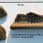
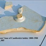
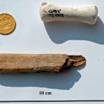
Finds from [001] This context included a mixed pottery collection of Post-medieval Redwares (PMR), and more modern whitewares and Transfer-printed wares (TPW) and others. Pottery from [003] contained a variety of fabrics including Tin-glazed Ware A (TPWA), Border Wares (BORD), Post-medieval Redwares, Frechen and Raeren Stonewares.

Trench 1 discussion

The earliest dating material here from layer [005] are 4 sherds of jar-bases of Raeren Stoneware 1480-1610 and 9 sherds of Tin-glazed Ware A 1570-1650. Together with the other pottery mentioned above, we may have occupation say around 1600-1750. Taken together with the cobblestones and animal bone, perhaps we are looking at some of the remains of the “Barn and Stable” and surrounding yard as mentioned on the early 18th century map. Towards the end of the 18th century a chalk floor is laid with occupation in the 19th century, in perhaps more ephemeral “yard” or garden type buildings. Another interpretation is that much of the tile dump [003] resulted from demolition or natural roof-line collapse of the main southern range of farm buildings into the garden, the range which was in great need of repair and rebuilding with a reconfiguration of the farmyard complex and other structures.

Trench 2

Trench 2, 3x1m, was placed 13.00m east of Trench 1 directly against the wall of the existing southern range of the farm building complex, to see any stratigraphical relationship of the main range to the garden. Up to 50cm of topsoil was removed to expose the main building range foundation, this consisted of a course of stretcher bricks at 57.30 OD, with a course of header bricks directly below, then a further 3 courses of header bricks forming a stepped plinth foundation. In the middle of the trench a large almost ovoid concrete structure appeared running roughly E-W, this may have contained a modern drain or sewer encased in concrete (there was a drain cover nearby), we left it alone and work either side of it.

Below layer [001] the soil changed to become [002], this firm grey/brown silty sandy clay was excavated to a thickness of 55-60cm. Within [002] a brick and tile drain was uncovered, it ran N-S 16cm below the current building foundations. The drain had been laid on a base of tiles with the two sides consisting of 3 courses of brick, fragments of pantile were used to cover the structure. The drain ‘gulley’ was 6cm wide at the northern end, opening out to 16cm wide at the southern end, from here the drain had an easterly curve, some of it may have joined a field-drain system seen in trench 3. The bricks had little or no “frog” and appeared to be reused to form the drain. Natural London Clay was reached at 56.46 OD.

Finds from within the drain and construction ‘cut’ together with the brick (although reused) may give a date of around 1800. The finds from the main [002] layer give a mixed picture, pottery included Transfer Printed Ware 1780-1900, Post-med Redware 1550-1800, White salt-glazed stoneware 1720-1780, Creamware 1740-1830, amongst other small amounts of porcelain and china fabrics. Other finds included two clay-pipe tobacco spurs, one dated 1750-1820 with the initials S & H, the other dated to 1660-1680. Unusually, a pipe-clay “wig-curler” was also recovered. Other material included a small amount of vessel and window glass, iron items – nails, bolts and possible lock-plates, an amount of roof tile and other bits of building material.

Trench 2 discussion

The pantile covered drain may date to the rebuilding of the farm complex sometime in the late 18th – early 19th century, as seen on the SBHB/HC/45/19 map mentioned above. There is then a mixed build-up or silting of material 1800-1900 [002] At some point in the late 19th to early 20th century the main farm building is rebuilt in brick into a dairy farm; this is the “plinth” foundation we can see as it sits on and is dug into the [002] layer.

Trench 3

Trench 3, 3x1m, was positioned at the NE end of the excavation area adjacent to the gate and fencing protecting the excavation area. The trench was placed here in an attempt to find possible evidence of the “moat” known to have partly surrounded the farm complex since at least 1584 and most likely well before.

After removing the dumped overburden by machine, a topsoil layer was excavated [003]; below this a firm grey/brown silty sandy clay [005] was uncovered at approx 56.75m OD. This context [005] could be similar to that of [002] in Trench 2, being a firm silty clay layer with little in the way of pebble and other inclusions, but with charcoal flecking, it was homogenous with little in the way of dump or tip layers within. Near the top of [005] a pair of circular field drains (side by side) entered the trench from the SW side; they ended before they reached the NE side. It is tempting to say they were emptying into the “natural” drain that was the silted-up moat, as the fall of the land is in the easterly direction. A sample of [005] was taken for environmental analysis, which is summarised below.

At approx 56.15m OD the context changed to a thin patchy chalky/redeposited clay layer. It was then noted that the change of layer began to dive down towards the SE end of the trench; below all this was the natural London Clay. We recorded this break of slope “a cut feature” from 56.15m to 55.70m OD, at which point the context turned into a black/grey silty layer [007]. It went deeper but at this level became difficult to excavate as we had reached our safety limit and the water-table had been found so the trench bottom kept filling with clear water from a possible spring line or the water-table.

Finds from Trench 3 included from topsoil [003] largely TPW, CREA and others in pottery, various window and vessel glass including a complete Express Dairy milk bottle with printed “College Farm, Finchley”. An amount of iron objects and some building material was also recovered.

From [005] the pottery included a jar rim and two body sherds of medieval South Herts Greyware (SHER) 1170-1350 with flinty inclusions – the oldest pottery recovered from the excavation – PMR, China, TPW and CREA fabrics. A notable and unusual vessel in CREA fabric was the base of a candlestick holder probably dating to 1800-1900. Various amounts of mostly bottle glass with two partial bottles were found dating to the 18th century. There was a miscellaneous collection of building material, not all was kept; a sample of what we processed included brick, peg/slate/pantile, floor tile and sewer-pipe. Other finds seen were more iron items and a small amount of animal bone and oyster shell. A bone knife handle with remains of the iron tang was also found here.

A visiting HADAS member spotted on the Trench 3 spoilheap a shiny object which turned-out to be a gold half-sovereign coin of 1898 in excellent condition. Unfortunately this was “unstratified,” but an interesting item not usually found on HADAS digs!

Trench 3 discussion

Below the modern topsoil and dumped over-burden we have context [005] which fills the cut “feature”; This feature appears to be the northern slope of a ditch dug into the natural clay, in the position and alignment where we were looking for the “moat”; it would perhaps be a fair assumption that we have found evidence for this feature. Many of the finds from [005] have a wide date range 1170-1900 but possibly most were deposited/dumped approx 1800-1900. It is understood the “moat” was finally backfilled around 1910, but it would seem there was a period of silting beforehand as there were no apparent tip-lines or separate dumping in the [005] fill. In the bottom of the ditch there was a dark-grey black/silty deposit, perhaps some primary silt with some metal-working debris or similar. Iit was difficult to interpret as excavating conditions were a problem in this spot.

Summary

The trial-trenches confirm that archaeological deposits do survive beneath below this parcel of land. From the sealed 17th- 18th century occupation layer in Trench 1 to the brick and tile drain in Trench 2 and moat in trench 3. But there does seem to be a substantial amount of silting-up in trenches 2 & 3 including the filling of the apparent ‘moat’ making interpretation difficult in these areas. They may have been open for some considerable time as part of the farmyard working and later garden use. The presence of the water-table may point to the survival of organic finds in the moat.

From an 1584 map the (excavated) area seems to have been general land in front of and SE of the original timber built farm buildings, there are entrance gates to a field surrounding the moat, another field and a gate to the then extensive woodland to the northern area of the farm. Further maps show the land as a spare or clear area, it then develops into a formally laid-out garden with paths and trees as in an 1816 map. An aerial photograph of 1926 (when the farm was finally closed) still sees it used for gardens. Only the plan showing the proposed works c1790-1816 has a difference as it indicates an “ox shed” and “barn and stables” on this area of land, these are not seen on any other maps (so far) so these buildings may have been a short term measure.

More work needs to be done on the development of the farm and moat plan, through various map and documentary sources. Due to the relative lack of medieval and earlier material in our excavations, preliminary work may indicate that the earlier heart of the farm lies under the present day car-park outside the NE range of the farm building surrounded by the (now filled-in) moat. The documentary sources, possible signs of medieval ridge and furrow from the Cranfield University survey (see part 1) on the playing fields east of the farm and reports of possible ridge and furrow on the Clitterhouse playing field in HADAS newsletter 250, Jan 1992 by Ted Sammes, make it fairly plain there should be medieval occupation evidence nearby.

A later observation

Adjacent to the car-park and roughly 15m NE of the farm building, a concrete base with broken metal ring was found covered-up by grass. This may have been the remains of a barrage balloon mooring-ring dating to the Second World War protecting the Handley Page aircraft factory based on land to the SE, formerly owned by Clitterhouse Farm (Pers. Com A. Simpson).

Acknowledgements and thanks:

Luisa Valejo, Alistair Lamberth & The Clitterhouse Farm Project. HADAS Fieldwork Team – Don Cooper, Vicki Baldwin, Roger Chapman, Tim Curtis, Melvyn Dresner, Eric Morgan, Jim Nelhams, Janet Mortimer, Joseph O’Kane, Sigrid Padel & Andy Simpson. Specialist Reports – Mike Hacker. Jacqui Pearce – selected finds identification.

St Barts Hospital Archive (various maps and documentary sources). Desk-Based Assessment (2008) of the Archaeology and Cultural Heritage on behalf of the Brent Cross Cricklewood Development Partners. Cranfield University – Geophysical Survey of Land at Clitterhouse Playing Field, Jan 2015. Sandy Kidd – Principal Archaeology Advisor (GLAAS) Historic England. Barnet Council Planning Dept.

Appendix 1

Analysis of Environmental Sample, Sample 2a, Trench 3, Context [005] by Mike Hacker, Feb 2016. (This is a summary of Mike’s report, the full report lies with the archive.)

Objective

To assess a soil sample of the fill of a cut feature, believed to be part of a medieval moat, to establish the composition of the fill and the environmental conditions at the time of its deposition.

Location and description of sample

Location: south eastern end of trench 3, depth c. 1m20 below surface level.

Taken from spoil heap c. 24hrs after excavation. (note: possiblity of some contamination from other material on spoil heap). Weight of sample: 1502gm, Condition: damp, Compaction: soft, Colour: dark, brownish grey,

Composition: silty clay. Forms ball and sausage but not ring, Inclusions: occasional pebbles

Processing method

Dispersed in water and repeatedly washed and settled in 15 lt bucket for 60 secs. Supernatant poured over 200µ sieve. Flot retained and air-dried. Residue air-dried. Dried residue swept with ferrite magnet to isolate iron rich particles. Dried residue passed through graded sieves.

Preliminary conclusions

Geology: The relatively high proportion of very fine sand, silt and clay indicates that the bulk of the material is derived from the underlying London Clay bedrock. The London clay does not contain material >250µ and the sand and pebble >250µ isolated from the sample must have been derived from other sources.

Visual observation of sub-rounded to well-rounded flint large pebbles present on the spoil heap and examination of the pebble and sand fractions from the sample suggests that the sand and pebble fractions of the sample is derived from the Dollis Hill gravel. This may be indicative of a head deposit. Alternatively it may be derived from gravel used for roads and paths imported onto the site from the deposits of Dollis Hill gravel on Dollis Hill (c1.5km from the site) or the Hendon plateau (also c1.5km from the site, BGS 1994 1:50,000 Series, North London Solid and Drift Geology, Sheet 258). There is evidence for gravel extraction from both these areas (LB Brent 1988 schedule of archaeological sites, GLHR record No, 1324570 and LB Barnet, Hendon, The Grove, 19thC gravel pit – Proc, Soc Ant. Dec. 1889, p16).

Organic material

The Rubus seed identified is indicative of such plants as blackberry or raspberry. They may have been growing in the ditch fill. However such seeds are very robust and as dietary fruit, they may be indicative of cess deposition. The preliminary identification of seed of Cyperaceae (sedge), a plant associated with damp habitats, would be consistent with it growing in ditch fill. No plant or animal evidence was recovered that would indicate that the ditch was retained standing water at the time the sampled fill was deposited.

Inorganic material

The presence of coal suggests a late medieval or post medieval date for the deposit.

The iron-rich material contained particles of slag and hammer-scale (fig. 3). This is possibly indicative of iron working. However the relatively small proportion of spheroidal hammer-scale suggests low temperature iron working. This would be consistent with activities such as agricultural tool or equipment maintenance or horse shoeing, as opposed to blacksmithing. Alternatively, depending on the date of the deposit, these particles, together with the presence of slag in the other fractions, could indicate material derived from ash from cast-iron hearths.

Potential for pollen analysis

A small sample of the in-situ ditch fill at a depth of c 1.30m below the surface was taken with a hand auger. This has been examined by Prof. Rob Scaife who has confirmed that the deposit contains well-preserved sub-fossil pollen (Scaife R. Pers. Com).

Trench 1 looking north (Melvyn Dresner)

Trench 1 looking north (Melvyn Dresner)

Trench 2 looking West, showing the brick & Tile drain, farm foundations and mystery concrete feature (Melvyn Dresner)

Trench 3 looking east including the moat cut into natural clay (Melvyn Dresner)

Desmond Collins by Don Cooper

It is with sadness that we report the death of Desmond Collins on the 9th March 2016. Desmond had a long and close association with HADAS. He taught archaeology at the Hampstead Institute and the UCL Institute of Archaeology, and was a contributor to several publications. He was especially interested in the evolution of early man and the development of culture. He jointly directed the excavations on West Heath in the 1970s. The results of the excavation were published under his and Daphne Lorimer’s editorship as “Excavations at the Mesolithic Site on West Heath Hampstead 1976-1981”. It was a BAR British Series 217 (1989) publication.
As Brian Jarman’s foreword to the book sums it up:
“The Hendon & District Archaeological Society wishes to express the big debt of gratitude it owes to Desmond Collins, who gave of his time and expertise to direct the West Heath excavations. With unfailing patience, he taught the skills necessary to excavate the site, encouraged members to follow their own lines of research and contributed in great measure to the success and enjoyment of the dig.”
Desmond was a life member of HADAS. His friends in HADAS would like to extend our deepest sympathy to Ann, his wife, and all his family. With thanks to Myfanwy Stewart for her contribution.
Other Societies’ Events Eric Morgan

Wednesday 4th May 6pm The Princes Alice Disaster Docklands History Group. Talk by John Lock. Museum of London Docklands No. 1 Warehouse, West India Quay, Hertsmere Rd, Canary Wharf E14 4HL. Visitors £2.

Saturday 7th May 10.30-5.30pm Before the Doors: London River and the Port in the 18th Century Docklands History Group 5th Annual Symposium. Museum of London Docklands No. 1 Warehouse, West India Quay, Hertsmere Rd, Canary Wharf E14 4HL. Information and booking: www.docklandshistorygroup.org.uk .
Wednesday 18th May 7.30pm Agincourt at the Islington Borders, Whitsun 1416. Islington Archaelogical & History Society. Talk by Lester Hillman, on echoes of Agincourt from Moorgate’s archery heritage to Dick Whittington’s stone on Highgate Hill. Visitors £1.
Wednesday 1st June 6pm London’s Great Fire and its Aftermath Talk by Dr Stephen Porter (Charterhouse archivist). Gresham College at the Museum of London (MoL), London Wall, EC2Y 5HN. Free.
Saturday 4th June 10.-30am-4.30pm.Local History Day British Association for Local History. St Andrew’s, Holborn, EC4A 3AB. A range of interesting sessions. Information/booking: www.balh.org.uk/events
Thursday 9th June 7.30pm From Forty Hill to Bulls Cross Illustrated talk by Frank Bayford, preceded by AGM & refreshments. Enfield Society, Jubilee Hall, 2 Parsonage Lane, jncn Chase Side, Enfield EN2 0AJ.
Friday 10th June 7.30 for 7.45pm Poet’s Corner Yard Dig, Westminster Abbey Enfield Archaeological Society. Talk by Chris Mayo (PCA) . Jubilee Hall (see May 9). Visitors £1. Refreshments.
Sunday 12th June Tea in the Park with Barnet Museum and Local History Society. The park is behind the museum, Wood St, Barnet. Includes musical events and fine teas.
Monday 15th June 3pm Another Look at Postcards Talk by Terence Atkins. Barnet Local History Society, Church House, Wood St, Barnet (opp. Museum).
Friday 17th June 7pm A Pilgrim’s Progress: Recreating a 14th Century Journey Talk by Steven Payne. COLAS, St Olave’s Parish Hall, Mark Lane EC3R 7LQ. Visitors £2.
Friday 17th June 7.30pm The French Navy During WWI Talk by Malcolm Barres-Baker. embley History Society, English Martyrs’ Hall, Chalk Hill Rd, Wembley HA9 9EW. Visitors £3.
Saturday 18th & Sunday 19th June London Open Garden Squares Weekend Visit gardens not normally open to the public (more than 200). Organized by London Parks and Gardens Trust and the National Trust. Including 10am-5pm Myddelton House Gardens (where HADAS has done a resistivity survey). For details see www.opensquares.org .
Sunday 26th June 11am-5pm Steam Open Day Markfield Beam Engine Museum, Markfield Park, Markfield Rd, South Tottenham N15 4AB. Free admission.
Thursday 30th June 7.30 for 8pm AGM, followed by: A Dip into the Archives Finchley Society, Drawing Room, Avenue (Stephen’s) House (address, see front page). Non-members £2, refreshments before and after.
_______________________________________________________________________________

With thanks to this month’s contributors: Bill Bass, Don Cooper, Eric Morgan
_________________________________________________________________________________

Newsletter-541-April-2016 – HADAS Newsletter Archive

By | Past Newsletters, Volume 10: 2015 - 2019‎ | No Comments

No. 541 APRIL 2016 Edited by Peter Pickering

HADAS DIARY – Forthcoming Lectures and Events.

Lectures are held at Avenue House, 17 East End Road, Finchley, N3 3QE, and start promptly at 8pm, with coffee/tea and biscuits afterwards. Non-members: £1. Buses 82, 125, 143, 326 & 460 pass nearby and Finchley Central station (Northern Line), is a 5-10 minute walk away.

Tuesday 12th April 2016: Douglas Killock: In the lift to the beach: a visit to the Lundenwic waterfront.
Tuesday 10th May 2016 Matt Symonds: Hadrian’s Wall: Life on Rome’s Northern Frontier
Tuesday 14th June 2016 ANNUAL GENERAL MEETING
Monday September 19th to Friday September 23rd. HADAS trip

Tuesday 11th October 2016 Professor Caroline Barron: Women in medieval London
Tuesday 8th November 2016 – Hazel Forsyth: The Cheapside Hoard

HADAS Newsletter Archive. Don Cooper

Finally after many years of hard work, all HADAS’ monthly newsletters are available on-line on the HADAS web site (www.hadas.org,uk). The newsletters have been digitised and are searchable by word or phrase, although, because they have been passed through OCR (Optical Character Recognition) software, there are still a lot of textual and spelling errors.

How to access this useful archive:

Go to the main HADAS web page at www.hadas.org.uk and on the right hand side of the page, you will see a heading “Newsletter Archive”, select and then on the newsletter archive page, you will see on the left panel, a table of volumes in five-year lots. If you want to see a copy of a particular newsletter, select the volume containing the year of publication and a list of the newsletters in that year will be listed,. Select the one you want.

To search all the newsletters for reference to a place or person, enter the search term into the field on the top right-hand side of the main newsletter archive project page. Enjoy.

February Lecture Melvyn Dresner

South Mimms Castle

Adam Corsini of the London Archaeological Archive and Research Centre (LAARC) talked to us about a 12th century Norman castle built just north of Barnet at South Mimms. Castle building in the 12th century could not happen without the King’s assent (and in this case an Empress). So how could there be a now-forgotten Castle so close to north London?

Adam explained how the castle was not forgotten though not widely known. On a 1504 map the area was marked Castle Acre Field, and the chalk quarry was known as Castle Quarry. It entered the archaeological record in 1918, when A F Major and G T F Cruickshank discovered the site. A local committee was established in 1931, funds were raised by 1933 to investigate further and in 1936 the site was scheduled (before it was understood properly) to protect it as an ancient monument. During World War Two it was used as a rifle range. In 1950, the North London Archaeological Committee was set up. It was not until John Kent (1928 – 2000), a numismatic specialist from the British Museum and Hertfordshire local archaeologist, got involved that archaeological investigation began in earnest. This investigation changed our understanding of castle building techniques, and shed light on a difficult and confusing period of medieval history – the civil war between cousins King Stephen and Empress Matilda known to historians as the Anarchy. The figure of Geoffrey II de Mandeville, first Earl of Essex, between 1136 and 1143, emerged as the possible castle builder.

The site was dug by volunteers during the 1960s including girls from Queen Elizabeth’s Girls’ School Barnet. Adam showed pictures of the site and how deep they were able to dig. The timber tower was built on raised ground, though most of the earthworks were constructed around the tower. Previously the assumption had been that with this type of castle the earthworks were built first and the tower placed on top. But South Mimms showed that the earthworks and tower construction were integrated. The earthworks were there partly to protect the wooden tower and partly to provide height as a viewing platform over the landscape.

Why was the castle built? Charters and history of the 12th century suggest political and military reasons. The location close to the Royal Forest of Enfield Chase points towards hunting, and material finds suggest later occupation of the site after the Anarchy in the late 12th century. A plaque found shows a lion emblem that could be associated with Henry I (Empress Matilda’s father ) or could be a hunting dog, (or a giraffe according to a shopper at Brent Cross Shopping Centre!)

The bulk of pottery found was South Hertfordshire Greyware with flint inclusions and mainly identified as cooking pots. They remind us that behind powerful men and women are potters, cooks, ploughmen, and herdsmen, who produce and prepare food; labourers who build; and crafts men and women who make pots, tools and weapons. The pottery was dated to late 12th century according to a London sequence. That is after the Anarchy, so the pottery either extends the use of the site, suggests its origin was later, or represents the time it took for local production to turn up in the City of London. Tools associated with construction include a pick and an auger; there was also re-used Roman material; a stone used for grinding that originated in Germany(classed as building material in the context of this site). Adam suggested it took 2,000 hours to build the earthworks and tower – either over say two months of intensive labour or perhaps up to two years. There was evidence (beam cut angles) for the tower tapering to improve structural strength.

Arrow heads dateable between 1130s and 1200 associated the site with hunting and archery. High status clasps from decorative boxes or books as well as Stamford ware represent a high quality, decorated and glazed import from outside the region that would have graced the table of a powerful magnate like Geoffrey II de Mandeville or his associates.

Though annual reports were produced each year between 1960 and 1967, the site had not been fully published by the time of John Kent’s death in 2000. After a few years a Committee was formed by John Clark, of the Museum of London, to bring the archive together and publish. In 2014 HADAS members and others were repacking finds at the LAARC and sharing these with more than 1,000 people over two days at Brent Cross Shopping Centre as part of the Unearthing Barnet project. The archive was deposited in LAARC in 2010 and ‘Excavations at South Mimms Castle, Hertfordshire’ was published as London and Middlesex Archaeological Society Special Paper 16, 2013.

[Editor’s Note: I spent two or three days at this dig in the 1960s]

Lurking in Churchyards Sylvia Javes

During our stay in the New Forest, we saw many ancient buildings and sites, but among them were some ancient trees, that were very much alive.
In Breamore churchyard stands a Yew tree that is completely hollow inside, with stems surrounding the hollow centre which is full of intertwined roots. When we visited it was covered with red berries. Breamore Church is Saxon, and it is thought the Yew was mature when the church was founded, making it at least 1000 years old.
Nearly as old is a Yew in Minstead churchyard, which had a narrow escape from felling in 1979. It was hollow inside and had had concrete poured into it, presumably to preserve it. However, a storm in 1979 caused half of it to fall, blocking the lychgate. It was decided to leave the remaining part of the tree and support it, and it is still growing and producing berries. Tree experts estimate it to be about 700 years old.
In the Gazetteer of ancient, veteran and significant yews:
Breamore: Classed as ancient and exceptional. Its girth is 1082cm at 60 cm height (over 35 feet). It is a female tree, but does have a young male tree growing within it! It is about 1000 years old.
Minstead: Classed as notable. Girth is 445cm at the ground (14ft 7ins).
Yew trees were revered as sacred before Christianity, and since churches were often built on pagan sacred sites, yews have long been associated with churchyards.
The leaves and seeds of yew are lethal if consumed, but the poisonous alkaloid found in ‘Taxus baccata’ contains some incredibly useful chemicals called taxanes. These are most concentrated in the needles of the English yew. Between the months of May and October, clippings from yew hedges in large gardens (eg National Trust gardens) are collected. Taxanes are chemically extracted from the clippings, purified, and converted into the chemotherapy drug Taxotere® (docetaxel).
Incidentally we have our very own ancient yew in Totteridge churchyard. It is classified as ancient, with a girth of 788cm at 90cm height (about 26 feet round), and thought to be up to 2000 years old.

Ipplepen Archaeological Project Jean Lamont

The name of Ipplepen may not be familiar to members of HADAS, but viewers of “Digging for Britain” may recall an episode, covering the South West, included a short piece on recent discoveries at Ipplepen.

In 2007, metal detectorists discovered Roman coins in a field near the small Devon village of Ipplepen which sits on the A381 road midway between Newton Abbot and Totnes. Funding for an excavation was found and Exeter University has been digging there since 2010. My sister lives a couple of miles away and took me to see the site when I visited her in August last year but sadly after the dig had closed for the year. (My sister is quite tolerant of my interest in archaeology and will visit archaeological sites with me “provided I explain what she is looking at!” – most remains on Dartmoor being pre-historic. So I was pleasantly surprised to hear that she had attended the Open Day.)

The site is recognised as being the most important discovered recently in Devon, consisting of the largest Romano-British settlement in Devon outside Exeter. Geophysical survey has shown that the site extends over 23 acres. It was previously supposed that Roman activity west of Exeter probably consisted of individual farmsteads. Successive digs have revealed continuous occupation of the site from pre-history with flints and Bronze Age pottery, Iron Age ring-ditch and round houses, Roman coins and pottery, through to the post-Roman period. The earliest coin dates from 150 BC. The most significant finds have been a Roman road with cart tracks and potholes (!), over an Iron Age track, with 15 skeletons beside the road (one dating to 655 – 765 AD). The 2014 dig uncovered a piece of Samian ware of 150 – 180 AD from Central Gaul stamped “Aucella”. postholes which are contemporary and in alignment with the road could be small rural houses, and evidence of smelting.

The orientation of the road is the same as the current road but slightly uphill from it and presumably linked the fore-runners of Newton Abbot and Totnes, both on tidal river estuaries (The Teign and the Dart), which would have been important for trading. No public announcement has so far been made of the dating of more of the skeletons or the result of the isotope analysis. It will be fascinating to discover where the people came from.

For further information visit the Exeter University website. http://humanities.exeter.ac.uk/archaeology/fieldwork/ipplepen/

The Ancient Greeks at Gallipoli Roger Chapman

Above ‘S’ beach lies the Turkish Martyrs memorial complex built on Eskihisarlik Burnu (Old fortress Point). Visited by hundreds of thousands of people each year it is one of the main Turkish memorials on the Gallipoli peninsular. It was occupied by the French during much of the campaign.

Less well known is what lies beneath the memorial and indeed is still visible in many places. This area is the site of the ancient Greek city of Eleaus. The Gallipoli peninsula was renowned for its wheat. It also profited from its strategic location on the main trade route between Europe and Asia, as well the ability to control shipping to the Black Sea.

Eleaus is reputedly the last resting place of the mythological hero Protesilaus, near a steep coastal cliff. According to Homer’s Iliad, Protesilaus was the first Greek to set foot on land during the Trojan War, for which – according to the will of the gods – he was also the first to die. His tomb at Elaeus lay on the European coast opposite Troy and became a place of pilgrimage for the cult of Protesilaus. Later, the temple contained votive offerings and was surrounded by a settlement. In antiquity the location was variously under Athenian, Persian, Spartan and later Macedonian control.

Alexander the Great is said to have visited Elaeus at the start of his Persian campaign in spring 334 BCE in order to visit the temple of Protesilaus. Here he made an offering before crossing the Dardanelles and himself becoming the first of his army to set foot in Asia.

During the 1915 campaign the French undertook an archaeological excavation of the site making significant finds. The French army brought five sarcophagi, jewellery, ancient pottery and other objects to Paris, which are now displayed in the Louvre. Some of the main stone walls of the city are still exposed and visible today.

Kentish Town Lock Bill Bass

Several members of HADAS visited the lock, part of the Regent’s Canal, during an ‘open weekend’ on the 23-24th January organised by the Canal & River Trust. The lock had been dammed and emptied so that the lock-gates could be renewed (this is undertaken every 25 years or so). The week before the ‘open weekend’ the old gates were craned out and new ones made of green Welsh Oak replaced them. As much of the original metal and other fittings are saved where possible, the work will take several weeks with other modifications being made.

Members of the public had access to the empty lock via a specially erected set of steps and platform, with a chance to inspect the new doors and the original brickwork and structure built c1820. There were many volunteers, together with display stands to explain the history of the lock and it’s operation. The area was once an important way of transhipping goods between the canal, railway and roads and many of the local industries e.g. timber yards, coal, wine merchants and icehouses.

Nearby a separate development for ‘Camden Lock Village’, a mixture of retail, leisure, arts cinema units and a new school will transform this part of Camden. Today this stretch of waterway is very popular with leisure barge and narrowboat traffic.

Canal Visits Jim Nelhams

In July 2012, “ownership” of the canals in England and Wales, which had been nationalised in 1948, was transferred from British Waterways to a charity named “The Canal and River Trust”. This continued the use of volunteers who had been involved in the restoration of canals. Unlike their predecessors, the Trust has realised the value of publicity, and organises a number of events each year. Some of these take advantage of lock gate replacements to allow people to visit and inspect the locks.

While going into a lock does not involve digging, the draining of the water does reveal artefacts that have found their way into the water, including the inevitable supermarket trolley. The opening of the lock allowed us to be among the first members of the public at the bottom of the lock for nearly 200 years. A number of Victorian glass bottles were on display. As the Trust puts it, it is an opportunity to unlock some secrets from the past.

The Trust also organises walks along the canal towpath, including sections of the Regents Park Canal between Little Venice in Paddington and King’s Cross. Most of these are on level ground. Of course, you can do this yourself at any time, since the towpaths are open to the public, and easily accessible. Or you can visit the London Canal Museum near King’s Cross.

Further details can be found at https://canalrivertrust.org.uk/places-to-visit?

In our recent trips, HADAS has visited a number of canals and canal infrastructure, including last year the steam pumping station at Crofton on the Kennet and Avon canal. Our 2016 plans include a visit to another section of this canal. Watch this space.

Coal Posts Bill Bass

On my occasional railway photographic forays to Potters Bar golf club I’ve noticed a stone ‘obelisk’ tucked away in the north-west corner by the lineside on top of the embankment. It was usually in over-grown land and difficult to get at. I assumed that it was a war memorial or folly that had been moved out of the way. On a recent visit the area had been cleared and the course not yet open so had the chance of a closer look, the stone is about 4m high with some letters and numbers, on the side facing the line is a shield which I recognised as the City of London.

Asking a green-keeper he said it was something to do with tax – and there were more of them. An internet search soon revealed that these were ‘Coal Tax Posts’, any coal being taken through the City of London had tax or duty payable, so the posts were set-up on all railways, canals and roads etc as a visible reminder of the tax due. Hundreds were set-up in a ring around London and many still survive, the figures on them refer the act and date they were set-up for.

More info here:

http://www.brookmans.com/history/projects/postspics3.shtml

Other Societies’ Events Eric Morgan

Saturday 9th April, 11-2.30 North London and Essex Transport Society. Enfield Spring Transport Bazaar. St Paul’s Centre, 102 Church St. Enfield EN2 6AR. Bus, Railway, Aviation and Military Transport, with books, photos, DVDs, Timetables, Maps, Memorabilia etc. Admission £3. Refreshments available

Thursday 28th April. 8pm Finchley Society. Trinity Hall, Nether Street, North Finchley N12 7NN. Environmental Issues. Talks by various speakers on subjects including Open Spaces, Litter, Roads (congestion, potholes and parking). Note venue. Visitors £2

Mondays 2nd and 30th May from 11am to 5pm. Markfield Beam Engine and Museum. Markfield Road, South Tottenham, N15 4RB Steam Open Days Admission Free.

Tuesday 3rd May 7.30 pm Enfield Society Jubilee Hall, 2 Parsonage Lane/junction Chase Side, Enfield EN2 0AJ Presenting Enfield. Talk by Joe Studman £3. First of a monthly series.

Monday 9th May. 3pm Barnet Museum and Local History Society. Church House, Wood Street, Barnet (opposite museum) Dickens: the Man and his Work. Talk by Paul Baker. Visitors £2.

Wednesday 11th May. 6pm. Gresham College at Museum of London 150 London Wall .The Five Catastrophes that made London. Talk by Simon Thurley on advances in Architecture. Free.

Thursday 12th May 7pm. London Archaeologist. Institute of Archaeology 31-4 Gordon Square WC1. AGM and Annual Lecture. Crossrail Liverpool Street Excavations. Alison Telfer.

Friday 13th May 8pm Enfield Archaeological Society Jubilee Hall, 2 Parsonage Lane/junction Chase Side, Enfield EN2 0AJ The Cutting Edge – Stone Tools in recent EAS digs. Talk by Neil Pinchbeck. Visitors £1. Refreshments 7.30pm.

Monday 16th May 7.30 pm Enfield Society Jubilee Hall, 2 Parsonage Lane/junction Chase Side, Enfield EN2 0AJ London’s Railway Termini – Part 1, North Talk by Roger Elkin

Thursday 19th May 2-5.30pm Gresham College Barnard’s Inn Hall, Holborn, EC1N 2HH Cultural Heritage and War. Symposium presented by Professor Tim Connell and a panel of experts, focusing on the current situation in the Middle East. Free, but reservations required – visit www.gresham.ac.uk , tel. 020-7831 0575 or e-mail enquiries@gresham.ac.uk

Friday 20th May. 7pm City of London Archaeological Society, St Olave’s Parish Hall, Mark Lane EC3R 7LQ Religious and Rirual Imagery on Roman Pottery from London. Talk by Fiona Seeley (MOLA) Visitors £2. Refreshments after.

Friday 20th May. 7.30pm Wembley History Society. English Martyrs’ Hall, Chalkhill Road, Wembley, HA9 9EW (Top of Blackbird Hill, adjacent to Church) Brent’s Brent Talk by Margaret Pratt and Cliff Wadsworth on the river’s past and present. Visitors £3, refreshments 50p..

Wednesday 25th May. 7.45pm Friern Barnet and District Local History Society. North Middlesex Golf Club, The Manor House, Friern Barnet Lane N20 0NL. John Donovan Memorial Lecture by Helen Fry. Germans who fought with the British. Preceded by AGM. Visitors £2. Refreshments.

Newsletter-540-March-2016 – HADAS Newsletter Archive

By | Past Newsletters, Volume 10: 2015 - 2019‎ | No Comments

No. 540 MARCH 2016 Edited by Deirdre Barrie

HADAS DIARY

Tuesday 8th March, 8pm. The Crossrail Archaeology Project. Lecture by Jay Carver, lead archaeologist with the Crossrail Project. The archaeology programme has involved more than 50 new investigations into London’s long history, spanning its prehistoric beginnings, the founding of Londinium in the Roman period, and a wealth of medieval and post-medieval sites right up to the City’s industrial and rail heritage age in the 19th century. Jay will provide an overview of the new discoveries undertaken during the last five years of work on Europe’s largest construction project, which has involved the efforts of more than 200 archaeologists and engineers.

Tuesday 12th April 2016, 8pm. In the lift to the beach: a visit to the Lundenwic waterfront by Douglas Killock

Tuesday 10th May, 8pm. Hadrian’s Wall: Life on Rome’s Northern Frontier. Lecture by Matt Symonds.

Tuesday 14th June 2016 ANNUAL GENERAL MEETING

Tuesday 11th October 2016 Talk by Professor Caroline Barron – title to be announced.

Tuesday 8th November 2016, 8pm. The Cheapside Hoard – lecture by Hazel Forsyth

All the above events, unless otherwise stated, will be held at Stephens House & Gardens (formerly Avenue House), 17 East End Road, Finchley N3 3QE, starting at 8pm, with tea/coffee and biscuits afterwards. Non-members are welcome (£1.00). Buses 82, 125, 143, 326 and 460 pass nearby. Finchley Central Station (Northern Line) is a short walk away.

—————————————————————————————————————–

Bradford on Avon Trip Jim Nelhams

We have had a good response and have now booked the hotel and the coach. We will be travelling on Monday 19th September and returning on Friday 23rd, staying for four nights at the Best Western Leigh Park Hotel on the outskirts of Bradford on Avon.

Full price is not yet known but seems likely to be around £470 per person sharing a twin or double room, and £520 per person with their own room. This is a slight increase on last year, but the first increase we have had for a while. We will need a deposit of £125 by the end of April with the balance by 15th July.

There are still places available, so if you want to add your name to the list or if you have any friends who would like to join the trip, please contact Jim or Jo Nelhams (contact info on back page). Each empty seat on the coach costs everybody in the group about £2 extra, so more people help to keep the cost down for everybody.

—————————————————————————————————————–

November 2015 Lecture – The History of the Royal National Lifeboat Institution – Keith Cunningham Report by Marilyn Burgess

The lecture was delivered by Keith Cunningham, founder member of the City of London Fundraising Committee, and focused on how the Royal National Lifeboat Institution was formed and the types of lifeboats used from the outset to present day.

The turbulent seas round the coast of Great Britain can be treacherous and over the centuries countless ships had come to grief. By the eighteenth century, with sea traffic increasing as trade grew, a competition was held to find the best design for a lifeboat. The competition was won by Henry Greathead who was a boat builder and in 1789 the first purpose-built lifeboat was built and stationed at South Shields by the Tyne.

The invention and development of the Shields rowing lifeboat continued, but shipwrecks were commonplace and regarded as an accepted way of life at sea. The number of shipwrecks around our coastline had risen to approximately 1800 a year and in 1823, when William Hillary, the MP for the Isle of Man, witnessed a tragedy, he made an impassioned plea to the nation and published a pamphlet detailing his plans for a lifeboat service. The pamphlets were sent to the Royal Navy, ministers and prominent citizens, appealing for what was called the National Institution for the Preservation of Lives & Property from Shipwreck.

William Hillary’s appeal fell on deaf ears, but he did not give up and re-branded his appeal. In 1824 his idea caught the eye of Thomas Wilson, Liberal MP for Southwark, and shipping magnate George Hibbert, a Whig MP and Chairman of the West Indies Merchants. The three men became a formidable force, and the campaign rapidly gathered momentum. As more and more benefactors came on board, an interim committee was set up, with King George IV assuring Royal Patronage and Prime Minister Robert Jenkinson, 2nd Earl of Liverpool, agreeing to be President.

A meeting was held on 4 March 1824 at the London Tavern in Bishopsgate, London, where Vice-President Archbishop of Canterbury Dr Charles Manners-Sutton presided, and the crowd unanimously passed 12 resolutions. It was agreed that an Institution be formed, which was to be funded by donations and annual subscriptions. The institute was named The Royal National Lifeboat Institution and the 12 resolutions still stand today as part of the RNLI’s charter, almost 200 years later.

We viewed slides featuring the Newquay Lifeboat Station and showing early lifeboats which had to be pulled out of the boathouse by man- and horse-power and taken to the shoreline, a rocket being launched to summon the crew. The old-style boats were very laborious and a team of men was required to drag them into position. Problems were encountered in the harbour with the tide going out and it was necessary to construct new buildings.

We were told of the improved lifeboats, which are primarily split into categories: inshore, offshore, all-weather boats and hovercraft. The fact that these new boats are state-of- the-art designs with an improved technology means that far smaller crews are needed, and volunteers are now paged when their assistance is required. The average age of a lifeboat is 20 years in service of RNLI, although the boats still have many further years’ usage, and from 2007 lifeboats have been sold on to China, and also countries in Africa and South America.

The tragedy of the collision of the Marchioness pleasure boat and the Bowbelle dredger in 1989 resulted in the loss of 51 lives, and it was identified by the Port of London Authority that lifeboats should be introduced to the Thames. There are four lifeboat stations covering the Thames: at Teddington, Chiswick, Gravesend and Tower Bridge (now relocated to Waterloo Bridge), with the Tower Lifeboat Station being the busiest lifeboat station in the country.

Keith gave us an insight into his involvement as a volunteer with the RNLI dating back to 1967, when he participated in a collection with a work colleague, and this led to his forming the City of London Fundraising Committee. His team of collectors grew to 49, and at their peak collected the sum of £9,000 in a day. The volunteers had some memorable experiences, in particular participating in the Lord Mayor’s procession on two occasions. Many thanks to Keith for an interesting talk.

___________________________________________________________________________

Membership Renewal – Stephen Brunning (Membership Secretary)

The HADAS membership year runs from 1st April, so all memberships are now due for renewal, apart from those new members who have joined since January this year. There is a separate form with this Newsletter for those people who pay by cheque, and I would ask that you return the form to me along with your remittance for the appropriate amount. Members who pay by standing order need take no action. The rates remain unchanged.

Anyone who thinks they should have had a Membership Renewal Form or Standing Order Form but hasn’t received one, anyone who wants to make their membership under Gift Aid and hasn’t already done so, or anyone who has any question at all about their membership, please contact me (contact details on back page).
___________________________________________________________________________

Help Required Don Cooper

In mid-2014 HADAS published “A Hamlet in Hendon”. We distributed it free to all our members and sold a small number of copies. To take its distribution to the next stage we need a volunteer to devise, create and implement a marketing plan so that this well-reviewed book reaches as wide a readership as possible both locally and nationally as well as among the history and archaeology community.

Should you feel that this is something you would like to take on, please apply to the HADAS chairman. See the contact details at the end of this newsletter.

___________________________________________________________________________

HADAS Trip – Lyndhurst – Day 5

Time to head home, but not without some stops on the way. First to Winchester. Luckily more than 40 days had expired since St Swithun’s Day.

Winchester Great Hall Dot Ravenswood

On Saturday the coach took us up to a high viewpoint, the wide paved area on the site of the Norman castle. We were to visit the only part of the castle that Cromwell left standing, the Great Hall (and, according to Jim, to see the world’s biggest dartboard!). Our guide was an enthusiastic walking encyclopaedia, never at a loss for a name or a date. Among other things, she told us that the hall was built between 1222 and 1235 at a cost of £500; it had always been an important legal and administrative centre, Edward I held a tournament and other celebrations there for the betrothal of his daughter in 1290, Sir Walter Raleigh stood trial there in 1603, and Judge Jeffreys held the Bloody Assizes there in 1685.

The Great Hall, with its tall, slim pillars of Purbeck marble, is said to be one of the finest aisled medieval halls in existence. But its main attraction must be the “giant dartboard” – in other words, the Round Table that hangs on the west wall.

The Round Table of Arthurian legend was first mentioned by the chronicler Wace in 1155, six or seven hundred years after the time when Arthur may have lived. It was later still, probably at King Edward I’s tournament in 1290, that the Winchester Round Table first appeared. I must admit that I had always assumed it to be a Victorian fake: a bit of nostalgic, nationalistic myth-making in the style of Tennyson’s Morte d’Arthur. So it was doubly surprising to learn that in its present form it was actually a Tudor fake, since the gaudy royal figure, the rose and the segments were painted in for that great self-publicist Henry VIII. Some things don’t change….

Winchester City Return Visit Andy Simpson

Having had a wonderful three years in Winchester from 1978 (!) doing my first degree, it was good to be back – so little time (relatively speaking), so many places to visit! Sadly the Roman House formerly on view beneath the Brooks Shopping Centre in the city centre had closed – but that just left more time to pop down to the former Winchester Chesil railway station site on the former GWR Didcot, Newbury and Southampton line, and the nicely preserved Bar End goods depot nearby, not visited since 1982! A good view of the related railway viaduct and nearby Iron Age univalate hillfort at St Catherine’s Hill was obtained from the coach. And a quick look at the city walls – including tiny fragment of Roman wall- in the SW corner of the city.

Winchester City Museum Deirdre Barrie and Andy Simpson

And of course a lingering look at the archaeological and social history displays in the City Museum, situated right by the magnificent cathedral. After a recent refurbishment, you start at

the top in Roman Winchester – Venta Belgarum – proceed to Saxon and medieval Winchester – Wintanceaster – Saxon Royal capital of England, and burial place of Alfred the Great. And a happy hunting ground for Martin Biddle excavating various Saxon Minsters and town centre sites in the 1960s/70s. Lots of pagan Saxon grave goods on display from extra-mural cemeteries – and end up in Victorian Winchester with its reconstructed shop fronts on the ground floor. Exit through Gift Shop, naturally. The models of Roman and medieval Winchester were excellent, as were the medieval pottery selections – a good primer for the evening class! Some lovely Roman mosaic and painted wall plaster fragments also, as shown in the accompanying photo. Must return soon…

The top gallery houses a star exhibit: the nearly complete Sparsholt Flower Mosaic floor, from a Roman villa excavated between 1965-1972 by D.E.Johnson.

The Winchester Moot Horn (12th C, copper alloy) needed a shoulder strap to support its weight, when it was used to call citizens to the “Burrough Mote” which was similar to today’s Council meetings. It could apparently be heard for several miles in the 1920s, when it was last blown, but it’s a replica which is now sounded at the annual mayor-making ceremony in May.

Another interesting exhibit is a rare suit of Almain Rivet armour, which might have belonged to the Tudor town guard, and was imported from Germany.

“Janeites” (i.e. fans of Jane Austen) would be particularly interested in the items owned by the author, which include a poem in her own hand, and a pretty purse with blue beads, which is supposed to have been worked by Jane herself. Jane came to stay in Winchester hoping for expert medical help to cure her last illness; but is buried in the Cathedral.

Apparently some local residents can still remember the preserved Victorian shop fronts (ground floor, Winchester Gallery) when they were in their original places. The tobacconist’s shop (does anyone remember “Passing Clouds” cigarettes?) is a particular favourite.

The museum is well worth a couple of hours of your day trip.

Winchester Cathedral – “Don’t Forget the Diver!” Liz Tucker

Whenever I go on a cultural trip including cathedrals, I am always overawed by their wonderful architecture and fascinated by their history – but after returning home, I often can’t remember which cathedral is which. This time we visited two, which were both built by William the Conqueror to replace older buildings in the area – and I made a special effort not to confuse Winchester with Salisbury.

After waiting for the Bishop to emerge from a service with various Mothers’ Union delegates, we went inside and heard a very interesting talk by a guide. The Romans, followed by the Saxons, settled in the area, which became Christian in 634 AD. In William’s time, Winchester was the capital of England, so he was determined to build something very imposing, similar to St Etienne in Caen. You can still see the original Romanesque style (with round arches) in the transepts, followed by different styles of Gothic in other areas. The long, high and narrow nave, with wonderful stone vaulting, is the most spectacular part of the building. The guide pointed out that the width of the nave was determined by the height of the trees available for the roof.

The choir stalls by the altar still have some of the original wooden carvings of secular subjects, such as dragons, green men and a cat with a mouse. We saw Jane Austen’s grave slab, and the plaque set up in her honour later on. Andrew and I, regular choral singers, were delighted to hear a lunchtime concert by a chamber choir, including Ave Virgo Sanctissima by the Spanish composer, Francisco Guerrero, which might have been sung in the cathedral at the wedding of Mary Tudor and Philip of Spain.

Over the centuries, parts of the cathedral were “knocked about a bit” by Henry VIII and then Cromwell. The glass from the huge West window was later reassembled in a random pattern, and the statues of the great screen were re-carved; St Swithun’s shrine, however, was lost without trace.

The greatest enemy of the building, however, was not human beings, but Nature. The Romans had diverted the River Itchen to form a moat, so that the cathedral is built on a very unstable river bed. It could not possibly support a spire like Salisbury’s, or even the large towers planned by William. The crypt floods regularly, and an Antony Gormley installation takes advantage of this effect.

In 1900, the cathedral was seen to be subsiding, and it was discovered that the foundations consisted of soft peat and floating logs. A deep-sea diver, William Walker, spent six hours a day, for six years, replacing these with concrete. My photograph shows two of the memorials to him. I wonder if the constant struggles with water gave rise to the legend of the patron saint making it rain for forty days, because he was annoyed that his tomb had been moved!

Whitchurch Silk Mill Ken Sutherland-Thomas

Our final visit of the holiday was to the Whitchurch Silk Mill.

The silk mill is the oldest in the UK still in the original building, and is a gem of industrial heritage. The mill is a Georgian building and uses 19th century machinery powered by the original water mill wheel.

On arrival, our party was split into smaller groups for guided tours of the premises. Being a Saturday, no work was being carried out, but our guide explained the manufacturing process and showed a film about the mill and its manufacture of silk. The objectives of the trust that runs the mill are to retain the skills of weaving on the machinery, to care for the building and its contents, and to inform the public about textiles.

Before leaving, many of our group made use of the mill’s catering facilities and well-stocked shop.

The mill is beautifully sited and the mill stream (part of the River Test) is home to many ducks. The mill clock is a feature of the outside of the mill, and was made in London by Handley and Moore in the late 18th century. It still provides the time for the citizens of Whitchurch today.

Correction

In the article on Clitterhouse Farm in the last edition I said in footnote 3 that ‘Westminster Abbey is used as a modern shorthand. The land was held by the Abbot of St. Peters at the time of the Domesday Book, only becoming known as Westminster Abbey at a later date.’ It has been pointed out to me that this is wrong. The list of landholders that stands at the start of Domesday Middlesex actually has ‘Abbatia de Westmonast’- i.e. Abbey of Westminster; ‘abbot’ would be ‘abbas.’ I’m grateful to Pam Taylor for pointing this out. Roger Chapman

The Royal Palaces of Enfield: January 2016 Lecture – Ian Jones,

Acting Chairman of Enfield Archeological Society Report by Liz Gapp

Ian started the lecture by explaining that there were two palaces in Enfield: Elsyng Palace at Forty Hall and Enfield Palace to the rear of Pearson’s, the Department Store in Church Street in Enfield.

The first part of the talk was about Elsyng Palace and the excavations carried out there. Photos of the first excavations carried out in the 1960s highlighted that in those days the ladies excavating wore skirts rather than trousers as now. Unfortunately, most of the site plans from the 1960s excavations have disappeared, although the site workbooks still exist and have proved very useful.

Not all of Elsyng Palace was excavated; a series of excavations were carried out to assess its size. An old view of the Lime Tree Avenue was shown to explain that where the path dropped down was where it would have been possible to see brickwork of the palace, which is no longer there. A lot of the lime trees came down subsequently in the storm of 1987. Due to a decision to reconstruct the Lime Tree Avenue, large holes were dug in readiness for the new trees. The first holes dug revealed brickwork at the base. As the site of Elsyng Palace is a scheduled monument, and the Enfield Society’s fieldwork director is a professional archae- ologist, English Heritage gave permission for the Enfield Archeological Society to excavate the holes that were being dug, as the bricks uncovered were deemed to be part of the palace. This meant relocating the trees being planted, with the benefit of uncovering further details of the palace. Unfortunately, the excavations were not extensive enough to identify the usage of these areas. In the tree pits, where the brick foundations were found, the only way to age them was via the mortar used.

There were very few finds to give clues to the likely usage; the area appeared to have been cleared of most of such items, probably when the palace was demolished. A very fine cesspit was uncovered, but unfortunately collapsed very shortly after being revealed. Initially vandalism was suspected, but then it was realised that the lime mortar’s fragility was the culprit, as once exposed to the air it could no longer hold the structure in place. Due to the collapse, it was not possible to find what was in the pit, as English Heritage strictures would not allow further excavation of it. A shame, as often such pits are a rich source of artefacts.

From excavation, there are believed to be four main stages of development; Phases I and II being medieval, while Phases III and IV date to Henry VIII’s time. Due to the closeness of the time frames for the phases, it is not entirely clear that there are four phases of development.

A brief outline of the palace’s history started with the fact that Henry VII and his daughter Margaret stayed in the Tudor apartments for hunting in 1497 and 1498. Custodianship of Elsyng went from the Ros family to Sir Thomas Lovell, speaker of the House of Commons, via marriage to Isabel, sister of Edmund Ros, after he was committed to an asylum. It returned to the family in the guise of his great-nephew Thomas Manners, 1st Earl of Rutland. Thomas Lovell was responsible for extending the building to become a ‘brick palace sufficient to receive the court in progress’.

Lambert Simnel, one of the many pretenders to Henry VII’s throne, was obviously considered to be harmless as he was parked in Thomas Lovell’s kitchen in 1487 and later became a falconer. Still alive in 1524, he was explicitly mentioned in Thomas Lovell’s will stating he was not to inherit anything from it when Lovell died. Part of a peregrine falcon’s skeleton found in the 1960’s verifies the royal connection, as these birds were bred only for royal use. In 1516, Henry VIII’s sister, Queen Margaret of Scotland, stayed there. Lovell also contributed to the clerestory and glazing of Enfield parish church, and founded the Holywell Priory.

Henry VIII obviously liked the house as a base for hunting, so persuaded the Earl of Rutland to give it to him in exchange for property in Leicestershire. Henry’s children spent part of their childhood there, and it was there that Elizabeth and Edward learnt of their father’s death. Extensive repairs were carried out in 1542 for a Christmas visit by Prince Edward and his sisters, and again under Elizabeth I, who is believed to have stayed at the Palace on at least four occasions. There are lots of documents associated with the building repairs which give good information.

To give an idea of the probable style and size of the Palace of which nothing is now visible above ground, we were shown comparable buildings viz:

Nonsuch Palace, if the long gallery is omitted, shows the size; Oaklands Palace in Surrey; a photo of a painting of the interior of Whitehall Palace illustrated the richness of the interiors which are likely to have existed at Elsyng Palace; Lincoln’s Inn entrance is likely to be similar to that at Elsyng Palace, particularly as it was funded by Sir Thomas Lovell; Nether Hall; and Rye House in the Lea Valley.

A geophysical survey done in the 1990s turned out to be quite misleading. In 2004, a new excavation was started. Magnetometry, geophysics and photos all looked very interesting, but because of rammed gravel in the area, proved to be deceptive. A beautiful brick drain was shown, from which many items were extracted. Other items found included carved brick and fragments of carved stone; post-medieval red wares, probably dated to the first half of the 17th century; tobacco pipes; several fragments of trailed Venetian glass, all from different vessels; and three mid-17th century fragments of Bartmann heads. A 1550s Cologne ware flagon was found, as was a very rare set of window glass triangles, some still framed in their original lead canes. There was also brick, probably from the service areas, as the main areas were believed to have been in stone. Similarly green-, yellow- and brown-glazed tiles were found, with more elaborate tiles in later areas. A large drain was found with a trickle of water still draining through it, and a couple of the archaeologists were able to get through 70 feet of this until the way forward was blocked by rubble.

The deer park that surrounded Elsyng Palace was fenced with wooden fencing and with several gazebos over the area. By 1586, Elsyng Palace had deteriorated and was rumoured to be in use as a Bath House and was only worth £7 a year. In 1650 a threshing barn was built, on top of the Tudor remains, and was then demolished in 1660s, unfortunately impeding excavation of the palace below. It is possible that the lake in the grounds is the remains of the 16th century water gardens.

With time running out, we were given a brief description of the Enfield Palace. This was given by Edward VI to his sister Elizabeth and for this purpose was sumptuously fitted out, although it is possible she never stayed there. After various incarnations, it was finally demolished in 1928 to make way for an extension to Pearson’s Department Store. The interiors of Enfield Palace were salvaged, and we were shown pictures of the amazing oak panelling and plaster-panelled ceiling from the house now in a local dwelling to which these have been moved. There are two rooms fitted out with these, which are in extremely good condition and also include a fireplace with Edward VI’s Royal Coat of Arms. There is also a second fireplace in the billiard room.

Many thanks to Ian for his talk, of which only a flavour has been possible in this write-up.

Other Societies’ Events by Eric Morgan

Saturdays 5th and 19th March, 11 am-12.30 pm, 1.30-3pm. LAARC – “Hidden London.” A tour exploring archaeological secrets from beneath some of London’s most iconic buildings, such as the “Gherkin” and the Olympic Park’s Velodrome. Book in advance, £9. Website:
https://www.museumoflondon.org.uk/london-wall/whats-on/events/?event_id=37808 or tel.
Museum of London 020 7001 9844.

Friday 11th March at 7.45, Enfield Archaeology Society. Jubilee Hall, 2 Parsonage Lane, Enfield, EN2 OAJ, “Barnet: the search for London’s only medieval battlefield.” Talk by Bruce Watson (M.O.L.A.) Visitors £1, refreshments.

Saturday, 12th March, 2016 – 2pm, The Historical Association (Central London Branch) “The Forgotten Invasion of England 1216,” talk by Dr Sean McGlynn. The Wolfson Room, (NB02) Institute of Historical Research, Senate House, University of London, Malet Street, WC1E 7HU. Members free, visitors £3, students free (with proof). No need to book. Join as a branch member (£12.50 p.a.) on the day and admission refunded. Enquiries: email chrissie@ganjou.com or tel. 020 7323 1192.

Tuesday 15th March, 8pm, Historical Association (North London Branch) Jubilee Hall, 2 Parsonage Lane, Enfield, EN2 OAJ. “The ‘Boffins’ of the First World War: the unknown story of the scientific revolution of the First World War.” Talk by Taylor Downing.

Friday 18th March, 7 pm. COLAS, St Olave’s Parish Hall, Mark Lane, EC3R 7LQ. “Behind the Scenes at the Crime Museum” – talk by Jackie Kelly (M.O.L.A.). £2.
(Meanwhile, “The Crime Museum Uncovered” Exhibition at the Museum of London, 150 London Wall, EC2Y 5HN, continues until Sunday 10th April. Tickets from £10 on-line. Advance booking advised to ensure entry. http://www.museumoflondon.org.uk/london-wall/whats-on/exhibitions-displays/the-crime-museum-uncovered )
—————————————————————————————————————-
CORRECTIONS: the item in the February Newsletter which reads “Thursday 17th March, 7.30pm Camden History Society Islington Town Hall, Upper St N1 2UD Radical Hackney Simon Cole. £1” should read:
Thursday 17th March, 7.30 pm, Camden History Society, Camden Local Studies and Archives Centre, 2nd Floor, Holborn Library, 32-38 Theobalds Road, WC1X 8PA “Artistic Symbolism in the Suffragette Movement.” Talk by Irene Cockroft, £1.

Also the talk given in the February issue for the venue Islington Town Hall should read:
Wednesday 16th March, 7.30 pm, Islington Archaeological & History Society, Islington Town Hall, Upper St, N1 2UD, “The Radical History of Hackney of the Past 400 Years.” Talk by Simon Cole. (Visitors £1).

The time of the talk for Friday 18th March’s Wembley History Society is 7.30 pm, and the correct title should be “Spies and Murderers in Westminster Abbey.” [February Newsletter].
—————————————————————————————————————–
Saturdays 2nd and 16th April, 11 am-12.30 pm and 1.30 pm – 3pm, LAARC, Mortimer Wheeler House, 46 Eagle Wharf Road, N1 7ED, “Shakespeare’s London” Tour. Delve into the world of Shakespeare, and handle artefacts such as bear bones discovered at London’s Elizabethan theatres. Book in advance, £9, Museum of London, 150 London Wall, London EC2Y 5HN, Tel 020 7001 9844 or book on line: https://www.museumoflondon.org.uk/london-wall/whats-on/events/?event_id=64810
Monday 11th April, 3pm Barnet Museum & Local History Society, Church House, Wood St Barnet (opp. Museum). “Remembering ‘Bungo” Talk by William Franklin on “An Apprecia- tion of the Life and Career of Field-Marshall The Viscount Byng of Vimy”. Visitors £2.

Friday 15th April, 7 pm, COLAS, St Olave’s Parish Hall, Mark Lane, EC3R 7LQ. “Archaeology in Bow, The Tudor Mansion That Became a Workhouse.” Talk by Les Capon and Lucy Whittington (AOC Arch.) There are 300 years of Tower Hamlets history on one site. Visitors £2. Refreshments after the talk.

Wednesday 20th April, 6pm, Gresham College at the Museum of London, 150 London Wall, EC2Y 5HN, “Sir Christopher Wren: Buildings, Place and Genius.” Talk by Simon Thurley. Free.

Wednesday 27th April, 7.45 pm Friern Barnet & District Local History Society, North Middlesex Golf Club, The Manor House, Friern Barnet Lane, N20 ONL, “A Green Spaces Walk”. Talk by Mike Gee. Visitors £2. Refreshments and bar.

Newsletter-539-February-2016 – HADAS Newsletter Archive

By | Past Newsletters, Volume 10: 2015 - 2019‎ | No Comments

Number 539 FEBRUARY 2016 Edited by Andy Simpson

HADAS DIARY – LECTURE PROGRAMME 2016

Tuesday 9th February 8pm Medieval Middlesex – The Archaeological Remains

By Adam Corsini. The talk will mainly focus on the archaeology found at South Mimms, both the excavations themselves and recent public engagement work focusing on its archive. The talk will also include findings of an excavation in Regents Park Road, Finchley.

Adam’s background is in Classical Archaeology, in particular the Roman period. After graduating, Adam worked as field archaeologist on sites within London as well as supervising training excavations in Rome. He joined the Museum of London’s Archaeological Archive in 2004 where he is the Archaeology Collections Manager. The Museum’s Archive is the largest of its kind in the world, storing records for over 8,500 excavations and over five million artefacts.

Tuesday 8 March The Crossrail Archaeology Project; Lecture by Jay Carver.

Tuesday 12 April In the lift to the beach; a visit to the Lundenwic waterfront by Douglas Killock

Tuesday 10th May Hadrian’s Wall: Life on Rome’s Northern Frontier Lecture by Matt Symonds.

Tuesday 14 June ANNUAL GENERAL MEETING

Tuesday 11 October Talk by Professor Caroline Barron – title to be announced.

Tuesday 8 November The Cheapside Hoard Lecture by Hazel Forsyth

Lectures are held at Avenue House, 17 East End Road, Finchley, N3 3QE, and start promptly at 8 pm, with coffee/tea and biscuits afterwards. Non-members: £1. Buses 82, 125, 143, 326 & 460 pass nearby and Finchley Central station (Northern Line), is a 5-10 minute walk away.

Lyndhurst trip day 4

The day started with a leisurely drive through the New Forest, interrupted occasionally by cows or wild ponies on or at the edge of the road. Our coach took us past Beaulieu Road station. A glance around showed very few buildings close by. Wikipedia came to my rescue.

Opened by the Southampton and Dorchester Railway (S&DR) on 1 June 1847, the station was not originally intended to serve the village of Beaulieu, which lies some 3.5 miles distant. The railway company were obliged to open it as a ‘personal’ station for Lord Montagu, a concession to him for allowing the railway to be built over part of his Beaulieu Estate.

A special signal would indicate to the train drivers that they should stop for Lord Montagu and his guests. The station was closed by the London and South Western Railway (which had absorbed the S&DR in 1848) on 1 March 1860, and reopened on 1 November 1895. It was de-staffed in the early 1960s.

Bucklers Hard Tessa Smith

When we arrived at the top of the grassy slope that leads down to the Hard all was peace and calm. However, it has not always been so. In the 18th Century Bucklers Hard was a noisy busy shipbuilding area which saw the launch of many huge and famous naval vessels, including several that fought at the Battle of Trafalgar. When the Swiftsure was launched over 3,000 people arrived in this tiny village and the landlord of the Ship Inn served over five hogsheads of beer to the happy spectators.

The Shipwright’s Cottage is furnished to show the difference in living conditions between skilled and unskilled workmen. The family of the skilled artisan was literate and educated and his wife ran a “Dame School”; the family of the unskilled artisan lived sparsely, their home being barely furnished.

Further down in the middle of the terrace is the Chapel of St Mary which in 1846 was an infant school. During later refurbishment work a cellar was discovered containing what were said to be clay candlesticks attached to the walls, giving rise to stories of smugglers’ dens.

During World War II motor torpedo boats were serviced and repaired here and segments of Mulberry Harbour were towed from the Hard across to the Normandy coast for the D-Day landings. It was here also that Sir Francis Chichester set sail and returned safely from his single-handed voyage around the world in Gipsy Moth IV

And so we ambled down to the river where our boat awaited us.

The Beaulieu River Jim Nelhams

A chance to rest our feet while we enjoyed half an hour cruising on the river, with commentary from our “Captain”.

The Beaulieu River, formerly known as the River Exe, is a small river flowing through the New Forest in the county of Hampshire in southern England. The river is some 12 miles (19 km) long, of which the last 4 miles (6 km) are tidal. The entire river, including its bed, is owned by Lord Montagu of Beaulieu, making it one of the few privately owned rivers in the world.

It rises near Lyndhurst in the centre of the New Forest and flows east and then south across the forest heaths to the village of Beaulieu. In fact, the source was very close to our base at the Forest Lodge Hotel. At Beaulieu the river becomes tidal and once drove a tide mill in the village.

Below Beaulieu the tidal river continues to flow through the Forest, passing the village of Bucklers Hard and entering the sea through the Solent. The tidal river below Beaulieu village is navigable to small craft. Since 2000 the navigable channel at the entrance to the river has been marked by a lighthouse known as the Millennium Lighthouse or the Beaulieu River Beacon.

Beaulieu Abbey and Palace House Micky Watkins

Beaulieu was a vast, rich abbey when it was built in the 13th century. It was founded by King John in 1204 for Cistercian monks and the King was determined to make it a very significant abbey which would atone for his sins. Starting with 30 monks who came from France, by the end of the 13th century there were 200 men living and working there; some were the white-clad monks devoted to prayer, others the lay brothers who kept the Abbey and its farms and forests functioning.

The design for the Abbey was based on the parent house at Citeaux. The Church was enormous, 336 feet long, though all that remains is the outline in stone. It is still possible to walk round the cloister and the lay brothers’ building, the Domus, survives, both the undercroft and the dormitory. The monks’ refectory has been converted into Beaulieu Parish Church. The whole site is very impressive and beautiful and left me wondering what proportion of national wealth was spent on religion in the middle ages.

In 1538 the abbot had to surrender the monastery to Henry VIII. The monks were found ecclesiastical appointments elsewhere and the King ordered the destruction of the Abbey. The stone and lead were used to build Hurst, Calshot and Cowes castles in defence against the French. The Great Gatehouse was the most impressive building left standing and was converted into a dwelling known as Palace House which became the centre of the estate. The new owner chosen by the King was Thomas Wriothesley who was right hand man to Thomas Cromwell.

Today the Palace House still incorporates the medieval gatehouse, but it is largely the work of Sir Arthur Blomfield who remodelled the building in Gothic style in the 1870s. In the dining room there is a massive old table made from a single elm tree, but the chairs are made in neo-Gothic style. There are contrasting styles of furniture as in any used house. The late Lord Montagu remembered the dining room as very draughty. The kitchen is fully furnished with Victorian aids – jelly moulds, rolling pins and an amazing array of shining copper saucepans. On the wall is a big array of bells to summon the maids to particular rooms.

The Upper Drawing Room is well lit by large Gothic windows on three sides, and there are beautiful views over the park. In medieval times this was a chapel, but now it serves as a music room. The ‘maids’ who were policing the rooms proved very helpful. To see the transition from the religious life to aristocracy and then flashy racing cars all on one site needs a lot of adjustment.

Beaulieu Motor Museum Simon Williams

The House was interesting, with visible remains of the old Abbey entrance porch & rib vaulting in the dining & lower drawing rooms. Rather amazingly, the cars were initially displayed inside the house; requiring wall demolition and rebuilding to get them in.

It was a thrill to discover the motorcycle collection, comprising, among others, a Norton Commando electric start and a Honda cbx 1,000 six which brought back strongly lost dreams & idle memories – and all in as-new condition. There was also a fine Rudge (the marque of T.E. Lawrence’s demise), a Vincent & a 1943 war-issue Harley.

In the car department, there was a comprehensive display to suit every enthusiast – from the dawn of motoring in 1875 and then the Edwardian elegance of the 1909 Rolls Royce Silver Ghost to the classic American Auburn of 1935 & the 1930’s big green supercharged racing Bentley, right up to the post-war years. It was good to see a pristine Jensen Interceptor, perhaps a little old-fashioned today (despite its timeless good looks), having a display light on entry saying ‘fasten seatbelts’! There was also an intriguing display of the rallying Audi Quattro & an RS Escort along with the Trotters’ Reliant 3-wheel van, Wallace & Gromit’s Austin van and a Bond car.

The site was served by a monorail despite it still being a rarity; perhaps not as fantastically futuristic today as I remember it to have been when it opened c. late 60s early 70’s. Altogether it was an outstanding visit.

The New Forest Church of All Saints, MINSTEAD Kevin McSharry

Minstead Church, on first sight, has the appearance of a motley collection of interconnected 17th century domestic dwellings. It certainly does not look like a church. Like topsy it has “growed and growed” over the centuries with little regard to continuity of style. Minstead Church is an “eccentric” building.

The interior of Minstead more than repays the journey to this out of the way place of worship. A place of worship certainly since the 13th century, and in all probability much, much earlier than that. The parishioners cherish All Saints as evidenced by a group of ladies enjoying a social afternoon making colourful covers for kneelers.

The church pulpit is a 17th century three–decker affair: the lower deck for, in times past, the Parish Clerk to intone the “Amens”; the middle deck for the reading of Holy Scripture; and the upper deck for the priest to preach his homily.

More detail at: http://minstead.org.uk/locations/all-saints-church/ and at: http://newforestparishes.com/about/minstead-church/ which include details of the possible Saxon font. The chancel and nave, which are of stone, date from the 13th century. The rest of the building, in red brick, is of 18th-century or later date, including the tower.

The Font, Norman-made, dating from the 12th Century is a survivor from the depredations of the English ‘Taliban’ of Puritan Cromwellian times. Found buried in the Rector’s garden in the late 1800s, it was restored to its rightful place in the church.

To the left of the sanctuary is a private pew/room for the local squire with its own entrance from the Churchyard. It even has its own fireplace, no doubt lit and stoked in good time for the attendance of the Squire and his family.

Buildings and particularly places of worship come alive for me by their association with people. Sir Arthur Conan Doyle, creator of Sherlock Holmes, Professor Challenger and Brigadier Gerard, is buried with his wife Lady Jean in the Churchyard near its southern boundary.

Sir Arthur & his wife once lived close to the Church & it was his wife’s wish for them both to be buried there, a wish not fulfilled until 7th July 1955, 25 years after Sir Arthur’s death and 15 years after the death of Lady Jean. Their original place of rest was their garden in Surrey. The wish was brought to fruition by Sir Arthur & Lady Jean’s daughters, and their grave, under the shade of an oak tree, has become a place of pilgrimage for Holmes aficionados.

All Saints, Minstead, encapsulates the history of the centuries. The Church has been added to piecemeal, each addition telling its own story. Unusually – or is it? – All Saints boasts a peal of six bells, its oldest dating back to the 14th Century. Minstead Church is a delightfully English, memorable, much loved, hallowed place, and is well worth a visit.

TO BE CONTINUED….

“What the Romans didn’t do for me” Janet Mortimer

My interest in local history began at Junior School in Burnt Oak when I was given a project to find out why the neighbouring roads were named as they were. Up to that point, I hadn’t noticed that road names had any significance but I was fascinated to learn that they did. In those days there wasn’t the luxury of sitting in your dressing gown googling the information, so off I trotted to the library and discovered that Goldbeaters Grove, where my school is, was named after Goldbeaters Farm on which Burnt Oak was built. I lived in Blundell Road which, with adjoining Maple Gardens, was named after John Blundell-Maple, a rich furniture magnate who lived in Orange Hill House (there’s also an Orange Hill Road). And, best of all, Watling Avenue was named after a Roman road, Watling Street – the MAIN Roman road – which still existed just up by the Co-op. I was suddenly surrounded by history, and spent the next few years willingly offering to dig over the garden in the hope that one of the Roman citizens had strayed off the beaten track and dropped a coin there.In later years I moved to Cloister Road in Child’s Hill and was given my own garden that I could dig over to my heart’s content. Coincidentally I have ended up around the same distance away from Watling Street, but I still haven’t found the elusive Roman coin. Obviously the Romans who came through these parts were either careful not to wander too far from the road, or had a tight hold on their money! I have found some “treasure” though – quite a few pieces of clay pipe, a military and livery button (later kindly identified for me by Andy), a tin soldier without his head, a china doll’s head without her body, some other bits and pieces and, curiously, a collection of polished stones. I also found two gold-looking rings with shiny stones which got me very excited … until I noticed the letters M&S inside. I found out that a rifle range had been located near my house, which would account for the military buttons, and probably the many pieces of clay pipe.

There is an interesting history of the area on the Child’s Hill Allotment Society website, http://childshillallotments.org.uk/pages/History.html , on which they say that they are still digging up old rifle shells! So, with my renewed interest in archaeology, I came across HADAS. I attended Jacqui Pearce’s excellent Finds in Focus course for a couple of years and met some lovely people. And when they told me they were doing a dig at nearby Clitterhouse Farm, I couldn’t resist going along. Being a complete novice, I had expected to just stand by and watch the experts, but as soon as I got there Bill put me to work. After some instructions and a demonstration, Andy handed me a shovel and I was off. I spent a wonderful few days there, even though after the first day I could hardly walk home, having over-exerted muscles that hadn’t been used for years! I was thrilled to find a few interesting bits – half a cup, and part of what we think was a candlestick – but the best piece eluded me and was found by Jim on the spoil heap. It was a Queen Victoria half-sovereign coin (sadly, still not a Roman coin!)

I guess I’ll just have to go back to digging my own garden, until the next time my endeavours with the mattock are required.

HOARDS: the hidden history of ancient Britain Audrey Hooson

The current display in room 69a at the British Museum is partly based on a joint three year BM and University of Leicester AHRC-funded project studying Roman and Iron Age hoards. Many of the hoards are shown with their containers. They range from prehistoric axes, the Salcombe hoard of tin and copper ingots from the MBA, 1300 – 1150 BCE, to the Hackney hoard of 80 $20 gold coins buried in 1940 for fear of a German invasion and found in 2007. Some of the sites may be familiar but there are many new items and ‘modern’ things such as a 3D print of the last money bag from the Beau Street hoard before the soil block was excavated in the laboratory. There are also sections explaining the P.A.S. & the Treasure Act. In addition to the display and research project the BM has published an interesting and well-illustrated book. ‘Hoards Hidden History’ by Eleanor Ghey (£12.99). HOARDS will be on display until 22nd May 2016. A free conference, Crisis and Continuity, Hoarding and Deposition in Iron Age and Roman Britain and Beyond, will be on March 11-12. An associated talk in the evening of March 11, on the Jersey Hoard, is £5.00.

Draft Historic England guidance on recording historic graffiti now out for consultation (via Peter Pickering and Guy Taylor)

Historic England are inviting views on guidance on recording historic graffiti with the aim of providing anyone working in the historic environment with basic advice and guidance for the systematic recording of graffiti of all types and ages.

It aims to cover:

• the range and types of graffiti • provision of practical advice on recording techniques • some indication of the range of information that can be learnt.

The deadline for comments is 5th February 2016.You can see the draft guidance and find out how to comment through the Historic England website:

http://www.historicengland.org.uk/about/what-we-do/consultations/guidance-open-for-consultation/

Excavations at Clitterhouse Farm, Cricklewood by HADAS Bill Bass

(Part 1 Introduction and timeline)

Site code: CLM15

Clitterhouse Farm, Claremont Road, Cricklewood, NW2 1PH

NGR: TQ 23689 86819, SMR: 081929

Introduction

Clitterhouse Farm is on land which is part of the widespread Brent Cross ‘Cricklewood Regeneration’ area and the buildings were scheduled for clearance. However, the formation of the ‘Clitterhouse Farm Project’ by local residents has seen the complex saved from demolition with the aim of eventually using some of the buildings as a community based centre. The farm buildings are currently used for an industrial hire business and private residence, the surrounding parkland is council owned. The Clitterhouse Farm Project contacted HADAS with a view to conducting fieldwork there as part of a community based archaeological investigation in July & August 2015. There has been no archaeological investigation of the farm complex as far as is known. The complex is neither Listed nor a Scheduled Monument.

History

The area lies within The London Borough of Barnet ‘Area of Archaeological Significance’ (ASAS), Child’s Hill 3a Clitterhouse Farm (western area). In 2007 Tara Fidler of English Heritage Greater London Advisory Service described the area thus:

“Clitterhouse originates from the word ‘clay’. The settlement was not mentioned in the Domesday Book, but the earliest known owner was in c1321 AD. There is documented evidence of the settlement as a land holding 1358 AD and it was a sub-manor of Hendon. Aerial photography reveals an earthen bank, possibly forming a moated enclosure around the manor. It is suggested that the moat may have served with Oxgate, across Watling Street, as a block house for the defence of London against the Viking attacks or possibly was even used by the Danes themselves. This suggests the enclosure may have been created in the Saxon period. Clitterhouse Farm remained a manor until the 1770s.”

‘Watling Street’ which runs approx. 500m to the west of Clitterhouse Farm is on the route of a SE-NW Roman road out of London now the A5 Edgware Road. Investi-gations have found occasional Roman evidence such as a 3rd century or later ditch near Dollis Hill Reservoir [BKO00] and a substantial flat-bottomed Roman ditch beneath Cricklewood Bus Garage [CBJ07]. From the 15th to the 20th century Clitterhouse Farm was owned by St Bartholomew’s Hospital. A HADAS member, Roger Chapman, has visited the archive, studying a range of legal documents, leases, maps and plans over this period (see below).

Some of the maps show the expansion and contraction of the building and the layout of the possible moat and fishponds, the maps show the ‘moat’ was filled in c1890s along with an extensive eastern range of the complex demolished c1892. A constant may be the ‘L’ shaped building, part of the south-east range of the complex, possibly the ‘farm building’ and ‘stables’ seen on the 1715 map.

Further information came from the Desk-Based Assessment (2008) of the Archaeology and Cultural Heritage on behalf of the Brent Cross Cricklewood Development Partners. This covers the regeneration area as a whole, of all periods, including further material on Clitterhouse such as ‘The Development of the Manorial Centre at Clitterhouse Farm’. This wider question on boundaries, land-use and urbanisation may form further research. Much of this land was sold to the Midland Railway, Handley Page and Hendon Aerodrome amongst others. A geophysical survey was carried-out by Cranfield University on the playing fields east of the farm in early 2015 as part of the Brent Cross ‘Cricklewood Regeneration’. This pointed to a possible Roman or medieval drove-way like feature, boundaries associated with the farm, some possible ridge and furrow, with possible civil-defence type structures and more modern features.

Clitterhouse Farm – A potted history Roger Chapman

This introduction to Clitterhouse Farm focuses on its woodland and agricultural history from the earliest records up until the twentieth century and introduces some characters who have played their part in its story. Space considerations preclude more of the story being told. The full story will have to wait until a full publication of the dig is produced.

The pre-14th century history of Clitterhouse Farm is vague, clouded in mystery and tied up in disputed Charters with great potential for historical myth making. Earthen banks around the Manor, identified by aerial photography, are suggested to form a moated enclosure and defence line against Viking invasion across to Oxgate lying on the western side of Watling Street. Hitchin-Kemp speculated that the Saxon Bleccenham may have been a Viking-raided homestead, blackened by fire, but then restored as ‘A house of clay … of such thickness of wall that even a modern bullet would scarcely penetrate. 1 From the ashes, Clitterhouse, the clay house ‘probably arose.2 A great story but evidence to support it is thin.

The Domesday Book records some 20 hides (approx. 2400 acres) of land held in Hendon by Westminster Abbey but this does not include Clitterhouse Farm.3 Montague Sharpe notes a number of omissions from Domesday including land lying east of Watling Street (Edgware Road) now constituting Edgware together with part of Hendon. This land, probably including Clitterhouse Farm, had been owned by the Abbey of St. Albans but was seized by William on account of the stiff opposition of Fritheric, 13th Abbot of St. Albans, a nephew of King Canute.

In 1086 these lands were still lying forfeit in the Kings hands and thus not included in the survey.4 In the mid fifteenth century the records available to tell the story of Clitterhouse Farm become rich and extensive.

The land passed into the hands of St. Bartholomew’s Hospital and, as it made an income from them, the hospital prepared plans and kept meticulous written records of transactions, many of which are available for research today.5

Clitterhouse Manor was owned by Robert Warner, lawyer and one time Under- Sherriff of Middlesex. In 1439 he bequeathed the land to the hospital on condition that a Chaplain and four youths would pray for him in the Lady Chapel. A new will made by him in the same year included his wife Margaret, his former wives Cecily and Eleanor and his parents among the beneficiaries of those prayers. The manor was eventually released to the hospital by Warner’s otherwise obstreperous heirs, his only daughter Elizabeth and her husband Walter Green in 1446. John Wakeryng, Master of St. Bartholomew’s had been appointed as an executor by both Warner and his widow. He appears to have been forced to make concessions in this case. Warner’s second will of 1439 stated that if Green proved obstructive he should receive nothing and yet in the final settlement he secured a payoff, for the payment of a sparrowhawk, of 60 acres of land, 6 acres of pasture and 36 acres of woodland in Clitterhouse, 6, 7. The hospital’s property in Hendon was augmented in 1446 by two nearby estates granted by Henry Frowyk and William Cleeve, Master of the King’s Works. The first, called Vynces, lay north of the Clitterhouse estate and the second, Rockholts, lay south of the road to Childs Hill.8

A survey in 1584 of Clitterhouse Farm “now in the tenure of Edward Kempe” was undertaken by Ralfe Treswell.9 Kemp is a name associated with the farm until 1794. An undated plan in the same archive, which appears contemporaneous, shows a farm of just over 200 acres comprising some 18 fields, each field denoted by a perimeter woodland strip, 2 woodlands, an orchard, farmhouse, outbuildings and a moat. Emphasising the importance of woodland, at the time, the survey identifies 1295 ‘timber trees’ on the farm. Timber of course was the building material of choice whilst wood would be used for fencing, wattlework and in large quantities for fuel.10

There is also a hint of a ten year coppicing cycle being practised with ‘Great Rockholts’ described as being cut in both 1537 and 1547. The farm land extended to the ‘West High Waie’ (Edgware Road) and was abutted to the south by land belonging to the Abbey of Westminster. To the north the landowner was Sir Roger Cholmeley, founder of Highgate School.11 Primary access to the farm was via a trackway from a feature called ‘Clitterhouse Cross’, presumably a wayside cross or Calvary, on the ‘West High Waie’ and this ran past fields called Great Rockholts, Noke Field and Great Camp to the House and then a track ran (roughly on the alignment of Claremont Road today) past Bente Field, Hill Field and Great Vince, out past Whitefield Gove which was on Cholmeley’s land.

The Edgware Road was liable to flooding in the winter so this route provided an alternative passage to Watford.

An Edward Kemp occupied the farm in 1610 when his house was broken into and a woman’s violet coloured gown worth 40 shillings and other personal goods were stolen. Three men and a woman were charged. Two of the men were ‘at large’, the other man pleaded not guilty and was acquitted. The woman, Joan Eliott, stood mute and for that reason was condemned to a punishment called “forte et dure”. She was laid on her back under a great weight and on alternate days was fed small quantities of bread or water until she died. Thomas Kempe was resident during the Common-wealth and in his will, proved in 1667, he left the lease of the farm to his son, Edward, with all the ‘corn, hay, cows, sheep etc.’

Edward continued at Clitterhouse until 1674 when he responded to a ‘hue and cry’ raised against highway robbers who had held up the mail coach on the Windsor Road and then fled across country from Hanwell to Harrow. All available able men in Hendon mounted their horses and tried to cut off the miscreants. Edward Kemp was to the fore and as he approached them they fired and he fell from his horse with a bullet in his side on the narrow lane leading to Hampstead Heath. He survived for 24 hours. The villains were caught, taken to Newgate gaol, and eventually executed. The body of their leader, Francis Jackson, was hung in chains on a gallows tree between the Heath and Golders Green.

The story of Clitterhouse Farm is one of gradual change from woodland to pasture, to haymaking/arable, with a significant disruption with the coming of the Midland railway in 1868, followed by a pre-first world dairy farm and then rapid industrial and suburban development up to the modern day. In the Domesday Book (1086) it is estimated that Hendon had a population of 250 but there was pannage (wood for 1000 pigs).12 By 1321, the time of the Black survey, there was still a great deal of woodland in existence, but less than at the time of Domesday.13 Moving forward to 1715 a new plan of the Farm, prepared by Robert Trevitt, shows a much reduced woodland area, only 19 acres out of 203 total. Most of the woodland strips surrounding the fields have been grubbed out.

A later note, dated 1753, states that by this time, more of the woodland areas, amounting to over 7 acres, have been grubbed out. This plan also contains a superb drawing of the farmyard in 1715 showing timber framed and weather boarded buildings making a tight group around the farmyard. John Roques 1746 plan ‘10 miles around London’ shows a range of 5 farm buildings called ‘Claters House’.

There have been numerous name variations over the centuries but there does appear to be a consistent link back to ‘clay’. The plan shows open fields all the way down to Childs Hill Lane, opposite which is an open piece of land on which stands two gallows with hanging bodies.

To the north of the farm buildings is a wood named Kemps Wood. The farms of Middlesex during the eighteenth century were on average about 100 acres in extent though there were many the size of Clitterhouse (200 acres) with the largest being Mr. Willan’s farm at Mary-le-bonne park of about 500 acres.

Middleton notes (1794) that the copses and woods of Middlesex had been decreasing for ages and in a few centuries they ‘will probably be annihilated’. Middleton also comments that hay was a key crop and that in the neighbourhood of ‘Harrow, Hendon and Finchley there are many hay barns capable of holding 30 to 50 and some even 100 loads of hay’.

Hendon by the time of the Tithe apportionment map of 1843 was 91% (7330 acres) in meadow and pasture use with just 0.04% of land (283 acres) in arable production and a miniscule 40 acres (0.005%) woodland. Clitterhouse Farm, now tenanted by Jonathan Caley, reflects this with the majority of fields shown as meadow and only some as arable.

In the 1860s the Midland Railway Company cut Clitterhouse farm in two (north to south), and built Claremont Road. The land west of the railway line became Brent Sidings in the 1880s. From 1876 until 1915 the Brent Gas Works supplied stations from Mill Hill to St Pancras, including the Midland Hotel and the railway workers cottages called Brent Midland Terrace (1897).

Clitterhouse farmland was much reduced in size, becoming a dairy farm. During the First World War the farm was 100 acres in extent and had “40 cows in full milk” producing 10 quarts per day on average.15

More land was sold for Hendon sewage works in the 1880s, and Hendon fever hospital (1890-1929).

The estate remained the property of St. Bartholomew’s Hospital until 1921, when it was sold to the War Department; it was later split up among private developers. Hendon Urban District Council acquired some of the land for playing fields and to provide a new home for Hendon Football Club. The southern part of Clitterhouse farm became the Beatty School of Flying before the First World War, which in turn was taken over by Handley Page’s Cricklewood Aerodrome and factory during 1917. Here Handley Page developed and tested Britain’s first bombers.

After the First World War, passenger flights to the continent became popular. In 1929 the Aerodrome was closed and the land became Laing’s ‘Golders Green Estate’. Jean Simmons, the actress, was brought up on the estate. Shortly after 1926 Hampstead FC (Hendon FC from 1946) rented some of the land from Hendon Urban District, finishing Clitterhouse as a farm. The rest of the land became a public open space. 16

Footnotes

1 F. Hitchin-Kemp .TLAMAS Vol. V Part III (1926). Clitterhouse Manor, Hendon.

2 Ibid

3 Note: Westminster Abbey is used as a modern shorthand. The land was held by the Abbot of St. Peters at the time of the Domesday Book only becoming known as Westminster Abbey at a later date.

4 Montague Sharpe. Middlesex in British Roman and Saxon Times (1919)

5 Archive of St. Bartholomew’s Hospital

6 Linda Clark (ed).The Fifteenth Century XIII: Explaining the evidence. Commemoration, Administration and the Economy (2014)

7 St. Bartholomew’s Hospital archive.. Cartulary of St. Bartholomew’s, p. 112, para 1145.

8 Victoria County History, County of Middlesex. Chapter 5.

9 Barts Archive . Treswell survey of Clitterhouse Farm 1584..

10 Rackham; History of the Countryside (paperback edition, 2000)

11 N.G. Brett-James. TLAMAS Vol VII Pt. I (1933) pp.1-90

12 N.G. Brett-James. TLAMAS Vol VI Pt. IV (1929) pp 547-632

13 Ibid.

14 Victoria County History, County of Middlesex. Chapter 5.

15 The National Archives. MH-47-86-101_01

16 Accessed 15012016 : https://www.barnet.gov.uk/citizen-home/libraries/local-studies-and-archives/pocket-histories/hendon-and-golders-green/clitterhouse-and-claremont-road-hendon-nw2.html

Post-Excavation Work Andy Simpson

Sunday Mornings at Avenue (Stephens) House continue in the usual vein with the ‘usual suspects’. Good work is being done on the Clitterhouse Farm finds analysis, with all finds now washed and marked. The bulk finds sheets have been completed and we are now working through detailed finds recording for the three trenches – Trenches 1 & 2 are now completed, with a nice selection of sixteenth century pottery recorded, and the deepest trench, trench 3 (up by the gate, for those who visited back in the summer), is now being worked on with its rich selection of Victorian pottery and glass, and other goodies to be revealed in the final report… There are occasional distractions such as the chance to tour the seasonal displays in the adjacent cellars, guarded by our good friend Igor…

Finds Processing at Avenue House, January 2016

OTHER SOCIETIES’ EVENTS compiled by Eric Morgan

Tuesday 2nd February Harrow Museum The Granary, Headstone Manor, Pinner View N. Harrow HA2 6PX 2.30pm Design & Construction in the Ancient World: How did they do it? Talk by Frank Weare Cost £3.50 AND Until Sunday 24th April Harrow & The Great War – Free Exhibition – incl. Tuesday 16th February 2.30pm Tubby & Me – The Great War seen through the eyes of Rev. B.F. Simpson (1st Vicar of St Peter’s, Harrow), talk by Karen Cochrane. Cost £3.50

Thursday 18th February, 7.30pm Camden History Society Burgh House, New End Square, NW3 1LT. Treasures of the National Portrait Gallery. Talk by Susan Jenkinson., Visitors £1

Tuesday 1st March, 2-3pm Harrow Museum (address above) The Development of Wealdstone from 1830-1952. Talk by Barbara Lanning. Cost £3.50

Wednesday 2nd March, 8pm Stanmore & Harrow Historical Society Wealdstone Baptist Church Hall, High St, Wealdstone. Wren’s St Paul’s at 300. Talk by V. Kermath. Visitors £1

Wednesday 9th March, 2.30pm Mill Hill Historical Society Trinity Church, The Broadway, NW7 Inns and Ale Houses of St Albans Talk by David Thorold (Curator of St Albans Museum). Preceded by AGM.

Monday 14th March, 3pm Barnet Museum & Local History Society Church House, Wood St, Barnet (opp. Museum) Eleanor Rathbone. Talk by Susan Cohen.

Thursday 17th March, 7.30pm Camden History Society Islington Town Hall, Upper St N1 2UD Radical Hackney Simon Cole. £1

Friday 18th March Wembley History Society English Martyrs Hall, Chalkhill Rd, Wembley HA9 9EW (adj. church) Spies & Wanderers in Westminster Abbey Talk by Bruce Thomson. Visitors £3 (philgrant69@aol.com or 020 8200 0211 for details);

Saturday 19th March, 11am–5pm LAMAS Archaeology Conference Weston Theatre, Museum of London, London Wall EC2Y 5HW

Morning Session 11-1; Recent Work

Afternoon session London Bodies: some recent advances. Tickets cost £12.50 before 1st March and £15 afterwards; Apply to joncotton1956@gmail.com or send cheque/PO payable to LAMAS and enclose SAE to Jon Cotton c/o Early Dept, Museum of London, 150 London Wall EC2Y 5HN; or via paypal from LAMAS website www.lamas.org.uk Usual displays of work & publications.

Wednesday 23rd March, 7.45pm Friern Barnet Local History Society North Middx. Golf Club, The Manor House, Friern Barnet Lane N20 ONL Archaeology Talk by Robin Densom Visitors £2 Refreshments and Bar

Tuesday 29th March, 12.30, 1.05, 2 and 2.30pm; Jacksons Lane Community Centre 269A Archway Road, Highgate N6 5AA Highgate Camp Remembered Trail Walks and Exhibition celebrating local WWI Heroes. For further details see www.jacksonslane.org.uk

Thursday 31st March, 8pm Finchley Society Drawing Room, Avenue House, East End Road N33QE Discussion Meeting For further details see Finchley Soc. Mar/Apr newsletter. Visitors £2

Newsletter-537-December-2015 – HADAS Newsletter Archive

By | Past Newsletters, Volume 10: 2015 - 2019‎ | No Comments

No. 537 DECEMBER 2015 Edited by Don Cooper

Doesn’t time go quickly, here we are in the middle of November looking forward to that end-of-year holiday period again!! Do the years go faster as we get older? It seems like only yesterday that I edited last December’s one!

May I, on behalf of the HADAS community, wish you and yours the compliments of the season and a healthy, happy and prosperous 2016.

HADAS DIARY

Tuesday 12th January, 8pm. Royal Palaces of Enfield. Lecture by Ian Jones (EAS)

Tuesday 9th February, 8pm. Medieval Middlesex – The Archaeological Remains by Adam Corsini.

Tuesday 8th March, 8pm. The Crossrail Archaeology Project. Lecture by Jay Carver.

Tuesday 12th April 2016, 8pm. In the lift to the beach: a visit to the Lundenwic waterfront by Douglas Killock

Tuesday 10th May, 8pm. Hadrian’s Wall: Life on Rome’s northern frontier. Lecture by Matt Symonds.

Tuesday 14th June 2016 ANNUAL GENERAL MEETING

Tuesday 11th October 2016 To be arranged

Tuesday 8th November 2016, 8pm. The Cheapside Hoard. Lecture by Hazel Forsyth

All the above events, unless otherwise stated, will be held at Stephens House & Gardens (formerly Avenue House), 17 East End Road, Finchley N3 3QE, starting at 8pm, with tea/coffee and biscuits afterwards. Non-members are welcome (£1.00). Buses 82, 125, 143, 326 and 460 pass nearby. Finchley Central Station (Northern Line) is a short walk away.

Church Farm House by Don Cooper

Church Farm House, Hendon (formerly Church Farm House Museum) is STILL vacant. The museum was closed in March, 2011, so it won’t be long until the 4th anniversary of its closing. We are being assured by Barnet Council that it is secure and being properly maintained and Historic England have not felt it necessary to add it to the buildings-at-risk register published last month (October 2015). Negotiations, we are told, are proceeding with Middlesex University but have yet to result in the signing of a lease.

Recent discoveries about Roman Britain By Peter Pickering
On 7th November I went to a conference organised by the Roman Society and the Association for Roman Archaeology. There were four lectures describing very recent excavations with remarkable new discoveries from Roman Britain. One was of a late Roman temple site in south-west Wiltshire, with a spectacular set of finds, especially miniature amphorae and hammers, and a large number of coins, over 30 of which have iron nails in them – perhaps originally attached to pieces of cloth, or hammered into a wooden post. There are also some lead curse tablets. But no indication, as yet, of what god or gods might have been worshipped there.
Professor Michael Fulford took us over the eighteen years of his excavation of part of Insula
IX of Silchester, which has finally come to an end, discovering so much more than the Society of Antiquaries had been able to find at the turn of the nineteenth and twentieth centuries. We were all fascinated by the evidence of a flourishing business of skinning dogs, presumably to make fur cloaks – a knife was found carved with an image of mating dogs. It seemed at the end that Professor Fulford was weaning himself and his students slowly from the excavation, having done some work on another insula, re-excavating some of the trenches of the Society of Antiquaries.
Sam Moorhead then gave an account of the Romans west of Exeter.
Although he was standing in for a lecturer who had been prevented from telling us about Binchester, the ‘Pompeii of the North’, no-one would have guessed this from his polished and fluent presentation. The discovery of the site at Ipplepen was due to two active and responsible metal detectorists (who recorded the GPS data for the many coins they found). The coins demonstrated that the Romans had not lost interest after they got to Exeter; geophysical surveying and excavation has already found many archaeological features over several acres, including a roadside cemetery. The dig has a strong community focus. Finally, Andrew Birley told us about the most recent work at Vindolanda, which continues to be one of the most important Roman sites in the country. He is the third generation of Birleys to work there. Among the finds he described were a gold coin of Nero, and the wooden toilet seat. The anaerobic conditions in parts of the site continue to reveal wooden writing tablets and other things which are usually lost. It looks as if the Vindolanda excavations will continue for many years.

The Sandridge Hoard by Jean Lamont

Members of HADAS may be interested to know that the Sandridge Hoard has now been conserved and has gone on display at the Verulamium Museum in St Albans. The Museum is open all year round and every day (Monday to Saturday from 10.00 to 17.30 and Sunday from 14.00 to 17.30), for public holidays such as Christmas check with the Museum, tel. 01727 751 810.

The Sandridge Hoard consists of 159 gold solidi and is the largest collection of solidi ever found in this country: they date from 375-408 AD and represent more wealth than most people could earn in a lifetime. There is no trace of the original container. The guidebook suggests a connection with one of the local villas and mentions Turnershall Farm a few miles away, itself subject of a separate display. Well worth a visit.

http://www.stalbansmuseums.org.uk/verulamium/ Website gives details of entrance fees / parking etc

Lyndhurst Trip – continued
Our aim on our trips is to visit a variety of places without spending too long on the coach. These cover a range of interests, with twenty of our travellers submitting interesting newsletter contributions about our stops, and related topics. Our thanks to all who have put pen to paper.

Day 2 started with one of our longer excursions – one hour to Stonehenge.

Visit to Stonehenge Liz Gapp

Our coach dropped us at Stonehenge in time for entry timed for 10.30. As the threatened rain was holding off, most of us decided to get the shuttle bus to visit the monument first, before visiting the visitor centre. Some people walked the 1¼ miles to the site; some later also walked back.

We had all been provided with audio tour guides. There were numbers on the site which went from 1 to 8 corresponding to the audio descriptions. These descriptions also gave additional numbers for more detailed information about specific aspects. The descriptions pointed out that Stonehenge is the only stone circle with lintels; there are 300 later mounds around the circle using it as a focal point; the monument is not a true henge as the ditch is inside the defensive mound, not outside it; it was all built over a period dating 3,000 – 2,000 BC; the famous bluestones reputedly from the Preseli Hills in Wales are the smaller of the upright stones, the larger ones being the Sarsen stones from a more local area, most likely the Marlborough Downs in North Wiltshire; the stones had been rearranged at various times in the past. As you walk round the circle of the monument various features such as the Heel Stone and the Slaughter Stone are described. You are kept to the edge of the monument by barriers, as the archaeology inside the barriers is deemed too fragile to be walked on.

Talking to people who knew the site from previous visits, it was felt the new approach, whether by shuttle bus or foot, was more atmospheric and a good way to enter the landscape.

After returning to the interpretive centre (around midday), we went to the café and ate our lunch. Then we went to the exhibition, not large but with quite a few interesting video displays. After this we briefly walked round the reconstructed village of round houses. There we also saw two sample bluestones and a Sarsen stone, the latter in a frame to enable it to be moved. This was so that it was possible to feel the difference between the two stone types. The Sarsen frame was set up with a challenge for people to try and move it, with pressure gauges to highlight how much effort it would take to move it, and showing that in practice it would have taken 200 people to move it.

We returned to the coach just after 13.00, although it wasn’t due to depart until 13.30. We were lucky, the rain had held off until just as we were due to leave the site, despite forecasts predicting an earlier start to the rain. Although not the warmest, it was a very enjoyable and rewarding visit.

Old Sarum Peter Nicholson

The grey skies which had threatened, but mercifully held off during our visit to Stonehenge began to rain at a sprinkle on the coach trip to Old Sarum, then dampened us more and more. This curtailed both the time we spent on site and the proportion of it we explored.

The boundaries of the site are those of an Iron Age hillfort probably from about 400 BC.
When the Normans arrived, ready-made defences seemed a bonus too good to ignore and William the Conqueror raised a motte and bailey castle inside in about 1070. Our access was easy – the coach park is in the outer bailey, so no need to climb a hill as at Danebury. The view in front of us was impressive. A deep ditch was crossed by a modern wooden bridge and, rising above us, the inner bailey with rubble cores of walls of extensive ranges of buildings remaining.

Besides castles, the Normans were great cathedral builders and, at Old Sarum, they built two in quick succession inside the hill fort. The first, begun about 1075 was small by their standards with three apses at the east end. The second, larger, cathedral is shown by the rubble cores of its walls, which remain to a little above ground level. The wall lines of the first cathedral, where they do not coincide, are shown by lines of modern paving.

Time moved on and so, unusually, did the cathedral. A hilltop site exposed to extremes of weather and inconvenient for trade had obvious disadvantages. Proximity to a Royal castle, which was politically advantageous in the eleventh century, had ceased to be so in the thirteenth when the Pope had excommunicated the King. After years of dissatisfaction and discord, the foundation stone of the present cathedral, on its site in the river valley below, was laid in 1220. After the cathedral went downhill, literally, Old Sarum did so metaphorically, suffering depopulation, and eventually became notorious as one of the rottenest of rotten boroughs.

Lyndhurst

With the inclement weather, we opted to return to the hotel. The rain having relented, it gave an opportunity for a brief walk around Lyndhurst itself. The town is quite small, with roads that do not lend themselves to modern traffic with frequent queues of traffic for some 400 yards from the traffic lights onto the High Street. Our hotel was at the northern end of the town opposite some open ground.

Race Course View by Vicki Baldwin
Although the ‘view’ is now open ground where the New Forest ponies come to graze, in the 18th Century there really was a popular racecourse here that appears on contemporary maps and continued in use until the 1880s.

The Custards Vicki Baldwin

Opposite the hotel a turning, Race Course View, had a sign stating that it led to The Custards, which turned out to be a rather unremarkable road with houses on either side. It seemed a very strange name so I started to look on-line for an explanation. The reason given on the website for ‘Rhubarb Cottage, The Custards, Lyndhurst (I know, I know!) was that there had been orchards on the site and the apples were eaten with custard. This seemed rather an odd link until I remembered that there was a variety of cooking apple named Costard. It would seem rather more logical that ‘The Custards’ is a corruption of ‘The Costards’ and these were the apples grown in the orchards.

Report on HADAS Lecture – October 2015 by Ken Sutherland-Thomas Scientific Methods in Archaeology.

Lecture by Dr Caroline Cartwright from Department of Scientific Research at the British Museum.

The speaker’s primary areas of scientific expertise were identification and interpretation of organics such as wood, charcoal, fibres and other plant remains, shell, ivory and bones from all areas and time periods in the British Museum’s collections. She has led expeditions in many parts of the world.

The quite technical talk was illustrated with digital images of many of the objects under investigation. The many techniques used in analysis and investigation were discussed. She highlighted the fact that the processes used for this apply pre-excavation, during excavation and post-excavation as well as in conservation. Also highlighted was the need for outreach with emphasis on the requirement to publish results in an understandable form both in print and online; and to stage exhibitions.

The advance in analysis techniques including ever more sophisticated microscopes in the last couple of decades has been phenomenal and the hardware and software required mean an expenditure of many millions of pounds. Very few organisations can afford this expenditure.

The storage and archiving of objects is important as future techniques not yet discovered may well enable more information to be extracted from these objects.

The meeting, which was well attended, concluded with a question and answer session. Dr Caroline Cartwright was thanked for a very interesting lecture.

CROSSRAIL at Liverpool Street

We have a lecture in March 2016 on the Archaeology discovered during the Crossrail project. Here is a taster from the Crossrail website
http://www.crossrail.co.uk/sustainability/archaeology/liverpool-street/

The Bedlam burial ground was in use from 1569 to at least 1738, spanning the start of the
British Empire, civil wars, the Restoration, Shakespeare’s plays, the Great Fire of London and numerous plague outbreaks. 2015 marks the 350th anniversary of London’s last Great Plague in 1665 and archaeologists hope that tests on excavated plague victims will help understand the evolution of the plague bacteria strain.

The Bedlam burial ground, also known as Bethlem and the New Churchyard, is located at the western end of Liverpool Street. Over 20,000 Londoners are believed to have been buried at Bedlam between 1569 and 1738. It got its name from the nearby Bethlehem Hospital which housed the mentally ill, although only a small number of Bedlam residents are believed to have been buried there.

In June last year Crossrail invited 16 volunteers to scour parish records from across the capital to create the first extensive list of people buried at Bedlam.

The resulting database of over 5,300 names and backgrounds is published on the Crossrail website and will inform Crossrail’s archaeological excavation.

The Roman remains that archaeologists uncovered at the Liverpool Street station tell a very different story from the Bedlam burial ground skeletons. Initially, skulls found in a small river channel were interpreted as wash-out from a Roman cemetery somewhere upstream. But the discovery in May 2015 of a reused cooking pot full of cremated human bones changed archaeologists’ minds…..

Be sure and put a note in your diaries for what I’m sure will be an exciting lecture.

A Member’s Lecture by Don Cooper

Stewart Wild is giving a lecture to the Mill Hill Historical Society at Trinity Church, Mill
Hill Broadway, on 13th January 2016 at 14.30 to 16.00 on the following subject: “History of Stevens’ ink and its Finchley connection”

Other Societies’ Events by Eric Morgan

Thursday, 7th January 2016 at 10.30 am. Pinner Local History Society, Town Hall, Chapel
Lane Car park, Pinner. “Memories of the Queen’s Coronation.” a talk by Terry Jenkins. Visitors £2, Please note the earlier time.

Monday, 11th January 2016, at 15.00 Barnet Museum and Local History Society, Church House, Wood Street, Barnet (opposite Museum). “Photographic History of Charing Cross Road.” Talk by Bob Kayne. Visitors £2.

Wednesday, 13th January 2016 at 19.45 Hornsey Historical Society, Union Church Hall, Corner Ferme Park Road/Weston Park N8 9PX. “The Friern Hospital Story.” Talk by David
Berguer (Chair, Friern Barnet and District Local History Society). Visitors £2 Refreshments.

Friday, 15th January 2016, at 19.00 City of London Archaeological Society (COLAS), St Olave’s Church Hall, Mark Lane, EC3R 7BB. “The Temples and Gods of Roman London.” Talk by Dominic Perring (Institute of Archaeology University College London). Visitors £2.

Thursday, 21st January, 2016 at 19.30 Camden History Society, Venue details not yet available. “Dinosaurs in Crystal Palace Park.” Talk by Professor Joe Cain. Visitors £1. Further details, visit www.camdenhistorysociety.org or Telephone Mrs. Jane Ramsay on 0207586 4436 (acting secretary)

Thursday, 28th January 2016, at 14.30 Finchley Society, Drawing Room, Avenue House, (now Stephens’ House and gardens) East End Road, N3 3QE. “Women and Medical Care in the First World War.” Talk by Dr. Susan Cohen. Non-members £2, refreshments (Please notice earlier time.

Acknowledgements
Thanks to our contributors: Peter Pickering, Jean Lamont, Vicki Baldwin, Ken Sutherland-Thomas, Liz Gapp, Peter Nicholson and Eric Morgan.