Number 539 FEBRUARY 2016 Edited by Andy Simpson
HADAS DIARY – LECTURE PROGRAMME 2016
Tuesday 9th February 8pm Medieval Middlesex – The Archaeological Remains
By Adam Corsini. The talk will mainly focus on the archaeology found at South Mimms, both the excavations themselves and recent public engagement work focusing on its archive. The talk will also include findings of an excavation in Regents Park Road, Finchley.
Adam’s background is in Classical Archaeology, in particular the Roman period. After graduating, Adam worked as field archaeologist on sites within London as well as supervising training excavations in Rome. He joined the Museum of London’s Archaeological Archive in 2004 where he is the Archaeology Collections Manager. The Museum’s Archive is the largest of its kind in the world, storing records for over 8,500 excavations and over five million artefacts.
Tuesday 8 March The Crossrail Archaeology Project; Lecture by Jay Carver.
Tuesday 12 April In the lift to the beach; a visit to the Lundenwic waterfront by Douglas Killock
Tuesday 10th May Hadrian’s Wall: Life on Rome’s Northern Frontier Lecture by Matt Symonds.
Tuesday 14 June ANNUAL GENERAL MEETING
Tuesday 11 October Talk by Professor Caroline Barron – title to be announced.
Tuesday 8 November The Cheapside Hoard Lecture by Hazel Forsyth
Lectures are held at Avenue House, 17 East End Road, Finchley, N3 3QE, and start promptly at 8 pm, with coffee/tea and biscuits afterwards. Non-members: £1. Buses 82, 125, 143, 326 & 460 pass nearby and Finchley Central station (Northern Line), is a 5-10 minute walk away.
Lyndhurst trip day 4
The day started with a leisurely drive through the New Forest, interrupted occasionally by cows or wild ponies on or at the edge of the road. Our coach took us past Beaulieu Road station. A glance around showed very few buildings close by. Wikipedia came to my rescue.
Opened by the Southampton and Dorchester Railway (S&DR) on 1 June 1847, the station was not originally intended to serve the village of Beaulieu, which lies some 3.5 miles distant. The railway company were obliged to open it as a ‘personal’ station for Lord Montagu, a concession to him for allowing the railway to be built over part of his Beaulieu Estate.
A special signal would indicate to the train drivers that they should stop for Lord Montagu and his guests. The station was closed by the London and South Western Railway (which had absorbed the S&DR in 1848) on 1 March 1860, and reopened on 1 November 1895. It was de-staffed in the early 1960s.
Bucklers Hard Tessa Smith
When we arrived at the top of the grassy slope that leads down to the Hard all was peace and calm. However, it has not always been so. In the 18th Century Bucklers Hard was a noisy busy shipbuilding area which saw the launch of many huge and famous naval vessels, including several that fought at the Battle of Trafalgar. When the Swiftsure was launched over 3,000 people arrived in this tiny village and the landlord of the Ship Inn served over five hogsheads of beer to the happy spectators.
The Shipwright’s Cottage is furnished to show the difference in living conditions between skilled and unskilled workmen. The family of the skilled artisan was literate and educated and his wife ran a “Dame School”; the family of the unskilled artisan lived sparsely, their home being barely furnished.
Further down in the middle of the terrace is the Chapel of St Mary which in 1846 was an infant school. During later refurbishment work a cellar was discovered containing what were said to be clay candlesticks attached to the walls, giving rise to stories of smugglers’ dens.
During World War II motor torpedo boats were serviced and repaired here and segments of Mulberry Harbour were towed from the Hard across to the Normandy coast for the D-Day landings. It was here also that Sir Francis Chichester set sail and returned safely from his single-handed voyage around the world in Gipsy Moth IV
And so we ambled down to the river where our boat awaited us.
The Beaulieu River Jim Nelhams
A chance to rest our feet while we enjoyed half an hour cruising on the river, with commentary from our “Captain”.
The Beaulieu River, formerly known as the River Exe, is a small river flowing through the New Forest in the county of Hampshire in southern England. The river is some 12 miles (19 km) long, of which the last 4 miles (6 km) are tidal. The entire river, including its bed, is owned by Lord Montagu of Beaulieu, making it one of the few privately owned rivers in the world.
It rises near Lyndhurst in the centre of the New Forest and flows east and then south across the forest heaths to the village of Beaulieu. In fact, the source was very close to our base at the Forest Lodge Hotel. At Beaulieu the river becomes tidal and once drove a tide mill in the village.
Below Beaulieu the tidal river continues to flow through the Forest, passing the village of Bucklers Hard and entering the sea through the Solent. The tidal river below Beaulieu village is navigable to small craft. Since 2000 the navigable channel at the entrance to the river has been marked by a lighthouse known as the Millennium Lighthouse or the Beaulieu River Beacon.
Beaulieu Abbey and Palace House Micky Watkins
Beaulieu was a vast, rich abbey when it was built in the 13th century. It was founded by King John in 1204 for Cistercian monks and the King was determined to make it a very significant abbey which would atone for his sins. Starting with 30 monks who came from France, by the end of the 13th century there were 200 men living and working there; some were the white-clad monks devoted to prayer, others the lay brothers who kept the Abbey and its farms and forests functioning.
The design for the Abbey was based on the parent house at Citeaux. The Church was enormous, 336 feet long, though all that remains is the outline in stone. It is still possible to walk round the cloister and the lay brothers’ building, the Domus, survives, both the undercroft and the dormitory. The monks’ refectory has been converted into Beaulieu Parish Church. The whole site is very impressive and beautiful and left me wondering what proportion of national wealth was spent on religion in the middle ages.
In 1538 the abbot had to surrender the monastery to Henry VIII. The monks were found ecclesiastical appointments elsewhere and the King ordered the destruction of the Abbey. The stone and lead were used to build Hurst, Calshot and Cowes castles in defence against the French. The Great Gatehouse was the most impressive building left standing and was converted into a dwelling known as Palace House which became the centre of the estate. The new owner chosen by the King was Thomas Wriothesley who was right hand man to Thomas Cromwell.
Today the Palace House still incorporates the medieval gatehouse, but it is largely the work of Sir Arthur Blomfield who remodelled the building in Gothic style in the 1870s. In the dining room there is a massive old table made from a single elm tree, but the chairs are made in neo-Gothic style. There are contrasting styles of furniture as in any used house. The late Lord Montagu remembered the dining room as very draughty. The kitchen is fully furnished with Victorian aids – jelly moulds, rolling pins and an amazing array of shining copper saucepans. On the wall is a big array of bells to summon the maids to particular rooms.
The Upper Drawing Room is well lit by large Gothic windows on three sides, and there are beautiful views over the park. In medieval times this was a chapel, but now it serves as a music room. The ‘maids’ who were policing the rooms proved very helpful. To see the transition from the religious life to aristocracy and then flashy racing cars all on one site needs a lot of adjustment.
Beaulieu Motor Museum Simon Williams
The House was interesting, with visible remains of the old Abbey entrance porch & rib vaulting in the dining & lower drawing rooms. Rather amazingly, the cars were initially displayed inside the house; requiring wall demolition and rebuilding to get them in.
It was a thrill to discover the motorcycle collection, comprising, among others, a Norton Commando electric start and a Honda cbx 1,000 six which brought back strongly lost dreams & idle memories – and all in as-new condition. There was also a fine Rudge (the marque of T.E. Lawrence’s demise), a Vincent & a 1943 war-issue Harley.
In the car department, there was a comprehensive display to suit every enthusiast – from the dawn of motoring in 1875 and then the Edwardian elegance of the 1909 Rolls Royce Silver Ghost to the classic American Auburn of 1935 & the 1930’s big green supercharged racing Bentley, right up to the post-war years. It was good to see a pristine Jensen Interceptor, perhaps a little old-fashioned today (despite its timeless good looks), having a display light on entry saying ‘fasten seatbelts’! There was also an intriguing display of the rallying Audi Quattro & an RS Escort along with the Trotters’ Reliant 3-wheel van, Wallace & Gromit’s Austin van and a Bond car.
The site was served by a monorail despite it still being a rarity; perhaps not as fantastically futuristic today as I remember it to have been when it opened c. late 60s early 70’s. Altogether it was an outstanding visit.
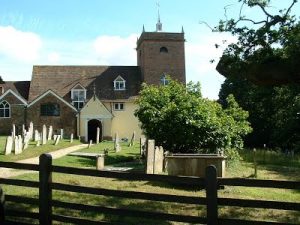
The New Forest Church of All Saints, MINSTEAD Kevin McSharry
Minstead Church, on first sight, has the appearance of a motley collection of interconnected 17th century domestic dwellings. It certainly does not look like a church. Like topsy it has “growed and growed” over the centuries with little regard to continuity of style. Minstead Church is an “eccentric” building.
The interior of Minstead more than repays the journey to this out of the way place of worship. A place of worship certainly since the 13th century, and in all probability much, much earlier than that. The parishioners cherish All Saints as evidenced by a group of ladies enjoying a social afternoon making colourful covers for kneelers.
The church pulpit is a 17th century three–decker affair: the lower deck for, in times past, the Parish Clerk to intone the “Amens”; the middle deck for the reading of Holy Scripture; and the upper deck for the priest to preach his homily.
 More detail at: http://minstead.org.uk/locations/all-saints-church/ and at: http://newforestparishes.com/about/minstead-church/ which include details of the possible Saxon font. The chancel and nave, which are of stone, date from the 13th century. The rest of the building, in red brick, is of 18th-century or later date, including the tower.
The Font, Norman-made, dating from the 12th Century is a survivor from the depredations of the English ‘Taliban’ of Puritan Cromwellian times. Found buried in the Rector’s garden in the late 1800s, it was restored to its rightful place in the church.
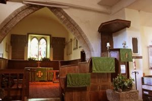 To the left of the sanctuary is a private pew/room for the local squire with its own entrance from the Churchyard. It even has its own fireplace, no doubt lit and stoked in good time for the attendance of the Squire and his family.
Buildings and particularly places of worship come alive for me by their association with people. Sir Arthur Conan Doyle, creator of Sherlock Holmes, Professor Challenger and Brigadier Gerard, is buried with his wife Lady Jean in the Churchyard near its southern boundary.
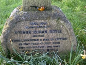 Sir Arthur & his wife once lived close to the Church & it was his wife’s wish for them both to be buried there, a wish not fulfilled until 7th July 1955, 25 years after Sir Arthur’s death and 15 years after the death of Lady Jean. Their original place of rest was their garden in Surrey. The wish was brought to fruition by Sir Arthur & Lady Jean’s daughters, and their grave, under the shade of an oak tree, has become a place of pilgrimage for Holmes aficionados.
All Saints, Minstead, encapsulates the history of the centuries. The Church has been added to piecemeal, each addition telling its own story. Unusually – or is it? – All Saints boasts a peal of six bells, its oldest dating back to the 14th Century. Minstead Church is a delightfully English, memorable, much loved, hallowed place, and is well worth a visit.
TO BE CONTINUED….
“What the Romans didn’t do for me” Janet Mortimer
My interest in local history began at Junior School in Burnt Oak when I was given a project to find out why the neighbouring roads were named as they were. Up to that point, I hadn’t noticed that road names had any significance but I was fascinated to learn that they did. In those days there wasn’t the luxury of sitting in your dressing gown googling the information, so off I trotted to the library and discovered that Goldbeaters Grove, where my school is, was named after Goldbeaters Farm on which Burnt Oak was built. I lived in Blundell Road which, with adjoining Maple Gardens, was named after John Blundell-Maple, a rich furniture magnate who lived in Orange Hill House (there’s also an Orange Hill Road). And, best of all, Watling Avenue was named after a Roman road, Watling Street – the MAIN Roman road – which still existed just up by the Co-op. I was suddenly surrounded by history, and spent the next few years willingly offering to dig over the garden in the hope that one of the Roman citizens had strayed off the beaten track and dropped a coin there.In later years I moved to Cloister Road in Child’s Hill and was given my own garden that I could dig over to my heart’s content. Coincidentally I have ended up around the same distance away from Watling Street, but I still haven’t found the elusive Roman coin. Obviously the Romans who came through these parts were either careful not to wander too far from the road, or had a tight hold on their money! I have found some “treasure” though – quite a few pieces of clay pipe, a military and livery button (later kindly identified for me by Andy), a tin soldier without his head, a china doll’s head without her body, some other bits and pieces and, curiously, a collection of polished stones. I also found two gold-looking rings with shiny stones which got me very excited … until I noticed the letters M&S inside. I found out that a rifle range had been located near my house, which would account for the military buttons, and probably the many pieces of clay pipe.
There is an interesting history of the area on the Child’s Hill Allotment Society website, http://childshillallotments.org.uk/pages/History.html , on which they say that they are still digging up old rifle shells! So, with my renewed interest in archaeology, I came across HADAS. I attended Jacqui Pearce’s excellent Finds in Focus course for a couple of years and met some lovely people. And when they told me they were doing a dig at nearby Clitterhouse Farm, I couldn’t resist going along. Being a complete novice, I had expected to just stand by and watch the experts, but as soon as I got there Bill put me to work. After some instructions and a demonstration, Andy handed me a shovel and I was off. I spent a wonderful few days there, even though after the first day I could hardly walk home, having over-exerted muscles that hadn’t been used for years! I was thrilled to find a few interesting bits – half a cup, and part of what we think was a candlestick – but the best piece eluded me and was found by Jim on the spoil heap. It was a Queen Victoria half-sovereign coin (sadly, still not a Roman coin!)
I guess I’ll just have to go back to digging my own garden, until the next time my endeavours with the mattock are required.
HOARDS: the hidden history of ancient Britain Audrey Hooson
The current display in room 69a at the British Museum is partly based on a joint three year BM and University of Leicester AHRC-funded project studying Roman and Iron Age hoards. Many of the hoards are shown with their containers. They range from prehistoric axes, the Salcombe hoard of tin and copper ingots from the MBA, 1300 – 1150 BCE, to the Hackney hoard of 80 $20 gold coins buried in 1940 for fear of a German invasion and found in 2007. Some of the sites may be familiar but there are many new items and ‘modern’ things such as a 3D print of the last money bag from the Beau Street hoard before the soil block was excavated in the laboratory. There are also sections explaining the P.A.S. & the Treasure Act. In addition to the display and research project the BM has published an interesting and well-illustrated book. ‘Hoards Hidden History’ by Eleanor Ghey (£12.99). HOARDS will be on display until 22nd May 2016. A free conference, Crisis and Continuity, Hoarding and Deposition in Iron Age and Roman Britain and Beyond, will be on March 11-12. An associated talk in the evening of March 11, on the Jersey Hoard, is £5.00.
Draft Historic England guidance on recording historic graffiti now out for consultation (via Peter Pickering and Guy Taylor)
Historic England are inviting views on guidance on recording historic graffiti with the aim of providing anyone working in the historic environment with basic advice and guidance for the systematic recording of graffiti of all types and ages.
It aims to cover:
• the range and types of graffiti • provision of practical advice on recording techniques • some indication of the range of information that can be learnt.
The deadline for comments is 5th February 2016.You can see the draft guidance and find out how to comment through the Historic England website:
http://www.historicengland.org.uk/about/what-we-do/consultations/guidance-open-for-consultation/
Excavations at Clitterhouse Farm, Cricklewood by HADAS Bill Bass
(Part 1 Introduction and timeline)
Site code: CLM15
Clitterhouse Farm, Claremont Road, Cricklewood, NW2 1PH
NGR: TQ 23689 86819, SMR: 081929
Introduction
Clitterhouse Farm is on land which is part of the widespread Brent Cross ‘Cricklewood Regeneration’ area and the buildings were scheduled for clearance. However, the formation of the ‘Clitterhouse Farm Project’ by local residents has seen the complex saved from demolition with the aim of eventually using some of the buildings as a community based centre. The farm buildings are currently used for an industrial hire business and private residence, the surrounding parkland is council owned. The Clitterhouse Farm Project contacted HADAS with a view to conducting fieldwork there as part of a community based archaeological investigation in July & August 2015. There has been no archaeological investigation of the farm complex as far as is known. The complex is neither Listed nor a Scheduled Monument.
History
The area lies within The London Borough of Barnet ‘Area of Archaeological Significance’ (ASAS), Child’s Hill 3a Clitterhouse Farm (western area). In 2007 Tara Fidler of English Heritage Greater London Advisory Service described the area thus:
“Clitterhouse originates from the word ‘clay’. The settlement was not mentioned in the Domesday Book, but the earliest known owner was in c1321 AD. There is documented evidence of the settlement as a land holding 1358 AD and it was a sub-manor of Hendon. Aerial photography reveals an earthen bank, possibly forming a moated enclosure around the manor. It is suggested that the moat may have served with Oxgate, across Watling Street, as a block house for the defence of London against the Viking attacks or possibly was even used by the Danes themselves. This suggests the enclosure may have been created in the Saxon period. Clitterhouse Farm remained a manor until the 1770s.”
‘Watling Street’ which runs approx. 500m to the west of Clitterhouse Farm is on the route of a SE-NW Roman road out of London now the A5 Edgware Road. Investi-gations have found occasional Roman evidence such as a 3rd century or later ditch near Dollis Hill Reservoir [BKO00] and a substantial flat-bottomed Roman ditch beneath Cricklewood Bus Garage [CBJ07]. From the 15th to the 20th century Clitterhouse Farm was owned by St Bartholomew’s Hospital. A HADAS member, Roger Chapman, has visited the archive, studying a range of legal documents, leases, maps and plans over this period (see below).
Some of the maps show the expansion and contraction of the building and the layout of the possible moat and fishponds, the maps show the ‘moat’ was filled in c1890s along with an extensive eastern range of the complex demolished c1892. A constant may be the ‘L’ shaped building, part of the south-east range of the complex, possibly the ‘farm building’ and ‘stables’ seen on the 1715 map.
Further information came from the Desk-Based Assessment (2008) of the Archaeology and Cultural Heritage on behalf of the Brent Cross Cricklewood Development Partners. This covers the regeneration area as a whole, of all periods, including further material on Clitterhouse such as ‘The Development of the Manorial Centre at Clitterhouse Farm’. This wider question on boundaries, land-use and urbanisation may form further research. Much of this land was sold to the Midland Railway, Handley Page and Hendon Aerodrome amongst others. A geophysical survey was carried-out by Cranfield University on the playing fields east of the farm in early 2015 as part of the Brent Cross ‘Cricklewood Regeneration’. This pointed to a possible Roman or medieval drove-way like feature, boundaries associated with the farm, some possible ridge and furrow, with possible civil-defence type structures and more modern features.
Clitterhouse Farm – A potted history Roger Chapman
This introduction to Clitterhouse Farm focuses on its woodland and agricultural history from the earliest records up until the twentieth century and introduces some characters who have played their part in its story. Space considerations preclude more of the story being told. The full story will have to wait until a full publication of the dig is produced.
The pre-14th century history of Clitterhouse Farm is vague, clouded in mystery and tied up in disputed Charters with great potential for historical myth making. Earthen banks around the Manor, identified by aerial photography, are suggested to form a moated enclosure and defence line against Viking invasion across to Oxgate lying on the western side of Watling Street. Hitchin-Kemp speculated that the Saxon Bleccenham may have been a Viking-raided homestead, blackened by fire, but then restored as ‘A house of clay … of such thickness of wall that even a modern bullet would scarcely penetrate. 1 From the ashes, Clitterhouse, the clay house ‘probably arose.2 A great story but evidence to support it is thin.
The Domesday Book records some 20 hides (approx. 2400 acres) of land held in Hendon by Westminster Abbey but this does not include Clitterhouse Farm.3 Montague Sharpe notes a number of omissions from Domesday including land lying east of Watling Street (Edgware Road) now constituting Edgware together with part of Hendon. This land, probably including Clitterhouse Farm, had been owned by the Abbey of St. Albans but was seized by William on account of the stiff opposition of Fritheric, 13th Abbot of St. Albans, a nephew of King Canute.
In 1086 these lands were still lying forfeit in the Kings hands and thus not included in the survey.4 In the mid fifteenth century the records available to tell the story of Clitterhouse Farm become rich and extensive.
The land passed into the hands of St. Bartholomew’s Hospital and, as it made an income from them, the hospital prepared plans and kept meticulous written records of transactions, many of which are available for research today.5
Clitterhouse Manor was owned by Robert Warner, lawyer and one time Under- Sherriff of Middlesex. In 1439 he bequeathed the land to the hospital on condition that a Chaplain and four youths would pray for him in the Lady Chapel. A new will made by him in the same year included his wife Margaret, his former wives Cecily and Eleanor and his parents among the beneficiaries of those prayers. The manor was eventually released to the hospital by Warner’s otherwise obstreperous heirs, his only daughter Elizabeth and her husband Walter Green in 1446. John Wakeryng, Master of St. Bartholomew’s had been appointed as an executor by both Warner and his widow. He appears to have been forced to make concessions in this case. Warner’s second will of 1439 stated that if Green proved obstructive he should receive nothing and yet in the final settlement he secured a payoff, for the payment of a sparrowhawk, of 60 acres of land, 6 acres of pasture and 36 acres of woodland in Clitterhouse, 6, 7. The hospital’s property in Hendon was augmented in 1446 by two nearby estates granted by Henry Frowyk and William Cleeve, Master of the King’s Works. The first, called Vynces, lay north of the Clitterhouse estate and the second, Rockholts, lay south of the road to Childs Hill.8
A survey in 1584 of Clitterhouse Farm “now in the tenure of Edward Kempe” was undertaken by Ralfe Treswell.9 Kemp is a name associated with the farm until 1794. An undated plan in the same archive, which appears contemporaneous, shows a farm of just over 200 acres comprising some 18 fields, each field denoted by a perimeter woodland strip, 2 woodlands, an orchard, farmhouse, outbuildings and a moat. Emphasising the importance of woodland, at the time, the survey identifies 1295 ‘timber trees’ on the farm. Timber of course was the building material of choice whilst wood would be used for fencing, wattlework and in large quantities for fuel.10
There is also a hint of a ten year coppicing cycle being practised with ‘Great Rockholts’ described as being cut in both 1537 and 1547. The farm land extended to the ‘West High Waie’ (Edgware Road) and was abutted to the south by land belonging to the Abbey of Westminster. To the north the landowner was Sir Roger Cholmeley, founder of Highgate School.11 Primary access to the farm was via a trackway from a feature called ‘Clitterhouse Cross’, presumably a wayside cross or Calvary, on the ‘West High Waie’ and this ran past fields called Great Rockholts, Noke Field and Great Camp to the House and then a track ran (roughly on the alignment of Claremont Road today) past Bente Field, Hill Field and Great Vince, out past Whitefield Gove which was on Cholmeley’s land.
The Edgware Road was liable to flooding in the winter so this route provided an alternative passage to Watford.
An Edward Kemp occupied the farm in 1610 when his house was broken into and a woman’s violet coloured gown worth 40 shillings and other personal goods were stolen. Three men and a woman were charged. Two of the men were ‘at large’, the other man pleaded not guilty and was acquitted. The woman, Joan Eliott, stood mute and for that reason was condemned to a punishment called “forte et dure”. She was laid on her back under a great weight and on alternate days was fed small quantities of bread or water until she died. Thomas Kempe was resident during the Common-wealth and in his will, proved in 1667, he left the lease of the farm to his son, Edward, with all the ‘corn, hay, cows, sheep etc.’
Edward continued at Clitterhouse until 1674 when he responded to a ‘hue and cry’ raised against highway robbers who had held up the mail coach on the Windsor Road and then fled across country from Hanwell to Harrow. All available able men in Hendon mounted their horses and tried to cut off the miscreants. Edward Kemp was to the fore and as he approached them they fired and he fell from his horse with a bullet in his side on the narrow lane leading to Hampstead Heath. He survived for 24 hours. The villains were caught, taken to Newgate gaol, and eventually executed. The body of their leader, Francis Jackson, was hung in chains on a gallows tree between the Heath and Golders Green.
The story of Clitterhouse Farm is one of gradual change from woodland to pasture, to haymaking/arable, with a significant disruption with the coming of the Midland railway in 1868, followed by a pre-first world dairy farm and then rapid industrial and suburban development up to the modern day. In the Domesday Book (1086) it is estimated that Hendon had a population of 250 but there was pannage (wood for 1000 pigs).12 By 1321, the time of the Black survey, there was still a great deal of woodland in existence, but less than at the time of Domesday.13 Moving forward to 1715 a new plan of the Farm, prepared by Robert Trevitt, shows a much reduced woodland area, only 19 acres out of 203 total. Most of the woodland strips surrounding the fields have been grubbed out.
A later note, dated 1753, states that by this time, more of the woodland areas, amounting to over 7 acres, have been grubbed out. This plan also contains a superb drawing of the farmyard in 1715 showing timber framed and weather boarded buildings making a tight group around the farmyard. John Roques 1746 plan ‘10 miles around London’ shows a range of 5 farm buildings called ‘Claters House’.
There have been numerous name variations over the centuries but there does appear to be a consistent link back to ‘clay’. The plan shows open fields all the way down to Childs Hill Lane, opposite which is an open piece of land on which stands two gallows with hanging bodies.
To the north of the farm buildings is a wood named Kemps Wood. The farms of Middlesex during the eighteenth century were on average about 100 acres in extent though there were many the size of Clitterhouse (200 acres) with the largest being Mr. Willan’s farm at Mary-le-bonne park of about 500 acres.
Middleton notes (1794) that the copses and woods of Middlesex had been decreasing for ages and in a few centuries they ‘will probably be annihilated’. Middleton also comments that hay was a key crop and that in the neighbourhood of ‘Harrow, Hendon and Finchley there are many hay barns capable of holding 30 to 50 and some even 100 loads of hay’.
Hendon by the time of the Tithe apportionment map of 1843 was 91% (7330 acres) in meadow and pasture use with just 0.04% of land (283 acres) in arable production and a miniscule 40 acres (0.005%) woodland. Clitterhouse Farm, now tenanted by Jonathan Caley, reflects this with the majority of fields shown as meadow and only some as arable.
In the 1860s the Midland Railway Company cut Clitterhouse farm in two (north to south), and built Claremont Road. The land west of the railway line became Brent Sidings in the 1880s. From 1876 until 1915 the Brent Gas Works supplied stations from Mill Hill to St Pancras, including the Midland Hotel and the railway workers cottages called Brent Midland Terrace (1897).
Clitterhouse farmland was much reduced in size, becoming a dairy farm. During the First World War the farm was 100 acres in extent and had “40 cows in full milk” producing 10 quarts per day on average.15
More land was sold for Hendon sewage works in the 1880s, and Hendon fever hospital (1890-1929).
The estate remained the property of St. Bartholomew’s Hospital until 1921, when it was sold to the War Department; it was later split up among private developers. Hendon Urban District Council acquired some of the land for playing fields and to provide a new home for Hendon Football Club. The southern part of Clitterhouse farm became the Beatty School of Flying before the First World War, which in turn was taken over by Handley Page’s Cricklewood Aerodrome and factory during 1917. Here Handley Page developed and tested Britain’s first bombers.
After the First World War, passenger flights to the continent became popular. In 1929 the Aerodrome was closed and the land became Laing’s ‘Golders Green Estate’. Jean Simmons, the actress, was brought up on the estate. Shortly after 1926 Hampstead FC (Hendon FC from 1946) rented some of the land from Hendon Urban District, finishing Clitterhouse as a farm. The rest of the land became a public open space. 16
Footnotes
1 F. Hitchin-Kemp .TLAMAS Vol. V Part III (1926). Clitterhouse Manor, Hendon.
2 Ibid
3 Note: Westminster Abbey is used as a modern shorthand. The land was held by the Abbot of St. Peters at the time of the Domesday Book only becoming known as Westminster Abbey at a later date.
4 Montague Sharpe. Middlesex in British Roman and Saxon Times (1919)
5 Archive of St. Bartholomew’s Hospital
6 Linda Clark (ed).The Fifteenth Century XIII: Explaining the evidence. Commemoration, Administration and the Economy (2014)
7 St. Bartholomew’s Hospital archive.. Cartulary of St. Bartholomew’s, p. 112, para 1145.
8 Victoria County History, County of Middlesex. Chapter 5.
9 Barts Archive . Treswell survey of Clitterhouse Farm 1584..
10 Rackham; History of the Countryside (paperback edition, 2000)
11 N.G. Brett-James. TLAMAS Vol VII Pt. I (1933) pp.1-90
12 N.G. Brett-James. TLAMAS Vol VI Pt. IV (1929) pp 547-632
13 Ibid.
14 Victoria County History, County of Middlesex. Chapter 5.
15 The National Archives. MH-47-86-101_01
16 Accessed 15012016 : https://www.barnet.gov.uk/citizen-home/libraries/local-studies-and-archives/pocket-histories/hendon-and-golders-green/clitterhouse-and-claremont-road-hendon-nw2.html
Post-Excavation Work Andy Simpson
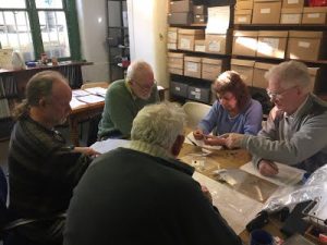 Sunday Mornings at Avenue (Stephens) House continue in the usual vein with the ‘usual suspects’. Good work is being done on the Clitterhouse Farm finds analysis, with all finds now washed and marked. The bulk finds sheets have been completed and we are now working through detailed finds recording for the three trenches – Trenches 1 & 2 are now completed, with a nice selection of sixteenth century pottery recorded, and the deepest trench, trench 3 (up by the gate, for those who visited back in the summer), is now being worked on with its rich selection of Victorian pottery and glass, and other goodies to be revealed in the final report… There are occasional distractions such as the chance to tour the seasonal displays in the adjacent cellars, guarded by our good friend Igor…
Finds Processing at Avenue House, January 2016
OTHER SOCIETIES’ EVENTS compiled by Eric Morgan
Tuesday 2nd February Harrow Museum The Granary, Headstone Manor, Pinner View N. Harrow HA2 6PX 2.30pm Design & Construction in the Ancient World: How did they do it? Talk by Frank Weare Cost £3.50 AND Until Sunday 24th April Harrow & The Great War – Free Exhibition – incl. Tuesday 16th February 2.30pm Tubby & Me – The Great War seen through the eyes of Rev. B.F. Simpson (1st Vicar of St Peter’s, Harrow), talk by Karen Cochrane. Cost £3.50
Thursday 18th February, 7.30pm Camden History Society Burgh House, New End Square, NW3 1LT. Treasures of the National Portrait Gallery. Talk by Susan Jenkinson., Visitors £1
Tuesday 1st March, 2-3pm Harrow Museum (address above) The Development of Wealdstone from 1830-1952. Talk by Barbara Lanning. Cost £3.50
Wednesday 2nd March, 8pm Stanmore & Harrow Historical Society Wealdstone Baptist Church Hall, High St, Wealdstone. Wren’s St Paul’s at 300. Talk by V. Kermath. Visitors £1
Wednesday 9th March, 2.30pm Mill Hill Historical Society Trinity Church, The Broadway, NW7 Inns and Ale Houses of St Albans Talk by David Thorold (Curator of St Albans Museum). Preceded by AGM.
Monday 14th March, 3pm Barnet Museum & Local History Society Church House, Wood St, Barnet (opp. Museum) Eleanor Rathbone. Talk by Susan Cohen.
Thursday 17th March, 7.30pm Camden History Society Islington Town Hall, Upper St N1 2UD Radical Hackney Simon Cole. £1
Friday 18th March Wembley History Society English Martyrs Hall, Chalkhill Rd, Wembley HA9 9EW (adj. church) Spies & Wanderers in Westminster Abbey Talk by Bruce Thomson. Visitors £3 (philgrant69@aol.com or 020 8200 0211 for details);
Saturday 19th March, 11am–5pm LAMAS Archaeology Conference Weston Theatre, Museum of London, London Wall EC2Y 5HW
Morning Session 11-1; Recent Work
Afternoon session London Bodies: some recent advances. Tickets cost £12.50 before 1st March and £15 afterwards; Apply to joncotton1956@gmail.com or send cheque/PO payable to LAMAS and enclose SAE to Jon Cotton c/o Early Dept, Museum of London, 150 London Wall EC2Y 5HN; or via paypal from LAMAS website www.lamas.org.uk Usual displays of work & publications.
Wednesday 23rd March, 7.45pm Friern Barnet Local History Society North Middx. Golf Club, The Manor House, Friern Barnet Lane N20 ONL Archaeology Talk by Robin Densom Visitors £2 Refreshments and Bar
Tuesday 29th March, 12.30, 1.05, 2 and 2.30pm; Jacksons Lane Community Centre 269A Archway Road, Highgate N6 5AA Highgate Camp Remembered Trail Walks and Exhibition celebrating local WWI Heroes. For further details see www.jacksonslane.org.uk
Thursday 31st March, 8pm Finchley Society Drawing Room, Avenue House, East End Road N33QE Discussion Meeting For further details see Finchley Soc. Mar/Apr newsletter. Visitors £2