DIARY
Please note the advertised lecture “Valley of the Kings” has been postponed to Tuesday October 1st. Ted Sammes has kindly stepped in to talk and show slides of archaeological sites in Jordan.
Tuesday 2nd April A SMALL DISPLAY by Tessa Smith
At the April Lecture, there will be a small display of finds from the “pipeline” field walking. Do come and look.
LECTURE: JORDAN VISITED
Ted Sammes, one of our Vice Presidents, needs no introduction. Last year he visited Jordan for a fourteen day period, little knowing what events would be in store for the Middle East later in the year.
Ted will show a selection of slides in an endeavour to cover much of the history/archaeology of Jordan. We will see views of PETRA, JERASH, a British Museum dig at TELL ES-SA ID1YEH, MOUNT NERO, MADABA and some desert castles, with a hot-spa site thrown in for good measure.
Saturday April 13th Local History Open Weekend with Barnet Local History
Society
Tuesday May 7th Annual General Meeting
Sunday May 12th Walk and afternoon visit to the Museum of Jewish Life, Finchley
Saturday June 8th Essex History Fair (See page 5 of February Newsletter)
Saturday June 15th Outing to Mapledurham, with Ted Sammes
Saturday July 13th Outing to historic Chatham Docks
Saturday August 10th Outing to Hertford – National Archaeologists’ Day
Lectures are held at the Central Library, The Burroughs, Hendon, at 8.00 for 8.30 pm.
Dorothy Newbury adds: the entry for the Weekend in Norwich (Fri/Sat/Sun August 30/31, September 1st) is full, but names are welcome for a waiting list (tel: 203 0950).
BELL LANE/BRENT STREET
Pneumatic drills are operating and excavators are digging up the underground public lavatories which are situated on the triangle at the junction of Bell Lane and Brent Street. Also on this site is a borough horse trough and a hanging blue plaque indicating it as a site of the “old Parish Cage”. Will all members in the area keep an eye on these two historic pieces – too much of old Hendon has already disappeared.
THE QUAKER TAPESTRY
A member of the Enfield Archaeological Society has sent us the following notice of an interesting exhibition at the Forty Hall Museum, Enfield.
“Since the C17 industrial welfare has developed as an expression of Quaker faith”.
This exhibition closes on 7th April 1991.
BARNET LOCAL HISTORY SOCIETY
and
HENDON AND DISTRICT ARCHAEOLOGICAL SOCIETY
present
A LOCAL HISTORY WEEKEND
SATURDAY 13 April – Barnet Museum, Wood Street Open Day 11.00 to 1.00 and 2.30 to 4.30 pm SPECIAL DISPLAY OF LOCAL ARCHAEOLOGY
ARRANGED BY: HENDON AND DISTRICT ARCHAEOLOGICAL SOCIETY
SUNDAY 14 APRIL – Guided walk round Historic Barnet
A leisurely stroll of about one and a half hours. It is hoped to include a visit to the site of a “Dig”. MEET at Barnet Museum, leave at 11.00. Repeat tour at 2.30. Numbers limited. Early booking advisable. Fee £1.00
To book phone Barnet Museum (440 8066) or 368 5345.
MEDIEVAL POTTERY IN GALLEY LANE, BARNET
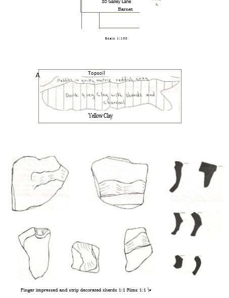
In 1975, some 500 sherds of mainly coarse grey/buff medieval pottery were found at my house in Galley Lane (TQ 227 967) when a gas main was laid. A shallow trench about 0.5m wide had been dug the-length of the drive but the sherds were concentrated into one area under the car port. The conglomerated mass of broken and heat reddened pieces of pottery, in very little soil matrix, was evidently composed of wasters from a nearby kiln whose whereabouts is unknown.
The nearest known medieval kiln, found in 1959 at Dyke Cottage, King’s Road, is about mile away. (TQ 233964). It yielded a range of 13th century pottery including at least 50 cooking pots, 30 jugs and 20 bowls (Penn 1960). Like the Galley Lane material “the pottery found was made of local clay, the coarser wares being tempered with fragments of flint and quartz” (Ibid).
In the late autumn of 1990 the house had to be underpinned by the front porch about 7 metres from the previous find spot. As the odd sherd or two had also turned up in the flowerbeds, both in the front and back gardens, the prospect of a new trench was of obvious interest. Predictably the excavation began when I was away for the day and no doubt some material was dumped on the skip. Nevertheless, I retrieved 191 sherds from a trench 2m x 0.75m deep. The pottery was much more loosely packed than in 1975 but the deeper trench enabled me to sketch the section which showed a reddened pebbly layer apparently over the pottery-bearing grey clay. Again there was no sign of a kiln.
There were 17 pieces of rim, flint tempered, of variable coarseness and a colour range of greys, buffs and brown/reds. One rim had simple finger-impressed decoration. There were 4 pieces of base and 170 assorted sherds 5 of which were decorated with finger-impressed strips of clay. Similar pieces had been found in 1975.
I think that the more important area had been pinpointed when the gas main had been laid. However, with so limited a trench it is not possible to postulate the whereabouts of the nearest kiln. It may have been destroyed when the house was built and so the pottery may not be in situ but, if it is not, considering the mass of material with so little soil matrix, I do not think it could have come far.
When site watching at Prospect Lodge, at the top of Galley Lane, towards Kinds Road, I found some 30 more sherds of similar fabric and one had impressed strip decoration. This time a large area had been trenched for the foundations of several new houses but still no sign of a kiln was apparent. Nevertheless it is always worthwhile looking down even the least prepossessing of trenches in areas of no previously known archaeological interest. The owner of Prospect Lodge had said “You are very welcome to have a look but there can’t be anything there.” In 1975, one of the Gas Board men, who became adept at bringing in the sherds to me and who had spotted the best piece of decorated ware, suddenly remarked “I always wondered why the old pottery we dig up in the trenches around here isn’t shiny.” I don’t think he was joking.
Penn D.F. 1960 A Medieval Industrial Site at Barnet.
In Barnet and District Record Society
Bulletin No.12, June 1960
By MYFANWY STEWART
MINIMART
Following the request for advice on car boot sales, John Enderby and Dorothy Newbury have been up at the crack of dawn on the last two Sundays setting up a stall at the Hendon Market. Dealers pounce like vultures and as a result we have been able to sell much of last years overs, as well as some recent items. If you have any good bric-a-brac available now, please ring 203 0950. As it was, we were sold out by 10.00 am and were able to leave much earlier than we had hoped.
DIGGING IN ASSYRIA The pork of the British Museum JOAN EDWARDS
The lecturer on March 5th was Dr John Curtis, Keeper of the Western Asiatic Antiquities of the British Museum. He told us that the Museum’s approach had been to look for Assyrian life on a more humble level than that of the previously excavated great palaces and temples. Due to the construction, from 1983 onwards, of a dam on the upper Tigris flooding of large areas near the Syrian and Turkish borders would result. It was decided to excavate as many of the sites which would be affected as possible and the British Museum took three village sites to excavate between 1983 and 1986: QASRIJ CLIFF, KHIRBER KHATUNIYEH, and KHIRBER OASRIJ.
At QASRIJ CLIFF potsherds were found on the river bank. On excavation a deep circular pit was exposed. This had originally been a grain silo but was later used for tipping rubbish including much late Assyrian pottery. No associated occupation area was found, possibly it had been carried away due to river erosion.
At KHIRBER KHATUNTYEH an occupation area was identified between two wadis. A small area was dug revealing a large “manor” house or administrative building. Walls were of mud brick and the area paved with stone. A grain bin and oven were present and profusion of broken pottery. Two rooms were excavated and a stone coffin found in the doorway between them. This contained no bones but had been used for storing grain. An iron sickle and whetstones were also in it. Two collapsed looms and unbaked clay loom weights were found and large “pithoi” with both flat and conical bases. It was evident that the site had been destroyed by fire in about 612BC probably by invading edes. The site actually flooded while digging was in progress and had to be abandoned. On the very last day a clay ram’s head rhyton was found.
At KHTRBER QASRIJ a settlement was found which was probably found by displaced people in 612BC escaping the tides occupation continued to about 500. Stone pavements and wall footings indicating an industrial site with a complex pit kiln surrounded by a paved area within a wall. The kiln was I1 metres deep and the roof had collapsed in on top of pots and wasters. These had been a large pit fire and probably the roof would be broken open after each firing and renewed. Some flooring stones in the surround had well-worn regular holes suggesting a pivot hole for the support of a potter’s wheel. Some complete pots were found and also nails made of pot normally used for attaching ritual displays on walls. Special finds were a stone weight carved as a sleeping duck and an Assyrian bronze fibula brooch in the shape of a woman’s torso.
The other excavations in 1989 and 1990 were undertaken at the famous sites of NIMRUD and BALAWAT. At NIMRUD a large store room was studied in Fort Shalmaneser. It had been destroyed by the Medes in 614 BC. It measured 10 x 4 metres and was 5 metres deep. Charred roof beams were found and a stone roof roller had fallen through the roof. The roof rollers were, and still are, used to roll a layer of plastered mud across the roof to seal leaks. On the floor were many bronze remains including circular bronze bosses similar to those illustrated decorating the leather harness of horses in the famous Assyrian wall reliefs but not beforefound in excavations. Glazed bricks were found scattered. These belonged to a wall panel which must have fallen in from the courtyard when the building was destroyed. The bricks bore the inscription for Shalmaneser III. They also had white paint faces and signs and black ink signs in Aramaic. This was the earliest use of Aramaic yet documented in the area. The white signs are not decipherable. Both lots of signs gave the assembler of the panel the order of assembly of the bricks. Bone plaques, faience beads and horse harness were found and also large pottery jars.
At BALAWAT work was undertaken in the area where Rasai found in the bronze gates now reconstructed in the British Museum. A small exploratory trench has begun yielding plaques and cylinder seals.
Dr Curtis finished his lecture by showing us slides of the fantastic gold jewellery and vessels found very recently by penetrating the floor of the palace courtyard revealing 4 tombs in brick vaults. The palace had previously been excavated by Woolley and Mallowan and this area had been thought to be the household area of the queens and their children.
THREE RIVER PIPELINE PROJECT
FINAL REPORT AND CONCLUSIONS VICTOR JONES
This project is to interconnect the water supply systems of the Lee, Colne and Three Rivers Water Supply Companies. It was planned a number of years ago, following the great drought of 1986. It is being constructed in stages and the Barnet western section is now completed.
The project was observed by the Department of Urban Archaeology of the Museum of London, particularly the Roman section. The Society has a copy of their report, and it is available to members.
In this Borough the work included cutting a track about 15 m wide and 5 km long, through several of the outer North Western districts, starting from Rowley Green. It then crossed fields in Arkley, over Barnet Road, through part of Scratchwood and the Edgware Golf Club, under the M1 Motorway, across Edgwarebury Fields, over the A41, and via more fields over Watling Street to the top of Brockley Hill and along Wood Lane, out of the Borough to Stanmore.
The work included removing topsoil from the full width of the service track (approx. 20m) then heaping this to one side, cutting a trench a little over a metre in width. This was sometimes deep (2 – 5m) to eliminate minor surface variation and produce an even base for the massive water pipe sections (approx. 0/8m and 5m). This was followed of course by the big job of laying, and joining and testing the system.
The Route. This passed through various places of known archaeological interest and much agricultural land, and offered a unique opportunity to examine areas not previously explored.
It commenced at a covered reservoir at Rowley Green, on a relatively unbuilt up area on the high ground to the north of the Borough. From there it first crossed a series of large fields at this level, then descending through further fields dropped approximately 10 m and crossed the Barnet Road about half way from Hiver Hall and the roundabout junction of the Barnet Road and the A1000.
The fields nearest Rowley Green had few if any artifacts – they had a thin topsoil layer approximately 15 cm deep, and an 0.25 m layer of large, rounded (water worn) irregular-shaped pebble (2 to 10 cm in). Below this was London clay. The next fields sloped down to meet the Barnet Road level. There was a greater depth of topsoil here, gradually increasing to approximately 20 cm at Barnet Road. There was also a layer of gravel of variable depth, with pebbles up to about 5 cm. below was the London clay.
A considerable range of artifacts was found, sparse at the higher levels and increasing in number and type from the high fields to those near the Barnet Road. The finds included a variety of tile, brick fragments, pottery sherds, clay pipes, small glass and pottery jars and similar items. Most are deposited at the Barnet Museum. None were earlier than 18th C. and much was Victorian.
The Viatores Route 167. The track crossed the line suggested by the Viatores as a possible Roman Route which passed through Edgware and Hendon and on to Londinium (Roman Roads in the SE Midlands, 1964).
This had been the subject of an early HADAS research project in the 60s, and reported (in the LAMAS Journal) by I. Robertson, the Director of the work. Careful search of the pipeline track did not find any evidence of a road or scatter of foundation material as would be expected if a road had existed.
No other artifacts were found in the area of track across these fields. This had passed through any line the Viatores suggested route would have crossed in the higher fields.
This agrees with earlier HADAS investigations, which included excavations and resistance surveys at several sites on the south of the Barnet Road. No evidence of a route was found by these investigations.
Re-examination of a possible line from the Viatores’ final “traced point” at Well End, Borehamwood to find a more south-easterly route with Rowley Lane as a possibility if the Route reached Well End is reliable.
South of the Barnet Road. The short section of pipeline between the Barnet Road and the point of the crossing of the A1000 was through the gardens of modern housing, and produced no material of interest. Such items as were found were tile, broken brick and small amounts of modern china shard.
The Scratchwood and Edgwarebury area. The route was then by tunnel under the A1000. This is to a point on the north side of the entrance of the Scratchwood Open Space picnic area. This area is a roughly rectangular grass space 200 x 250 m. The track crossed the picnic field diagonally to the southeast, and passed through the woodland area for about 500 m.
This was interesting and quite different to any other area we observed. It was almost completely without artifacts (with the exception of a 2 m square area in which fragments of a modern plate, cup etc. were found).
The soil throughout the wood consisted of light, fibrous matter from 15 to 20 cm in depth, then up to 0.5 m shading from light to darker brown of a clayey soil mix into the solid London clay, all penetrated to about 1.2 m deep.
The woodland over the track length appeared uncultivated and may perhaps have been so since the once-great Middlesex Forest covered our ancient county.
The Doomsday Book mentions food for 1000 pigs in the woods of the adjacent manor of Stanmore and 800 for Hendon.
Edgware Golf Course. The route then crossed a small section of Edgware-Golf Course. most of this is at this point on rubble filled land. It is low, has drainage streams from the higher ground, and was subject to in-filling as a council waste dump of the 20s and 30s.
I was told by the Chairman of the Golf Club that much earlier it was the site of a country residence with lake and gardens etc. This might be an interesting subject for a documentary research project, to trace its previous history for our records. The area as could be expected produced many finds of very recent material.
Edgwarebury to Brockley Hill. The route proceeds eastwards over the fields of Edgwarebury Farm to the A41. The search here produced a quantity of finds of the various types of 18th-19th C. material, scattered fairly evenly through the central part of the area. Near the M1, where the ground is low and wet, relatively few finds were made. Increasing numbers occurred as the first field was crossed, then the quantity found remained fairly uniform throughout the central area of the fields.
A small concentration of worked flint wasters was found at a point in these fields. The range of finds other than this continued from the central to a point about two-thirds of the way to the A41, and then tile and brick fragments, some possibly of Roman type, also occurred.
At about 100 m of the A41, a concentration of 19th C mixed building and domestic remnants were found spread over about a 10 m circle. The material was recent and might have been dumped, or have been from a small collapsed building.
In previous HADAS field-walks some years ago in the general area, Roman tile and other material had been found, and further walks to establish the spread and/or source of material could be of interest.
Brockley Hill East Side. The A41 was crossed about a third of the distance from the Edgware roundabout at the foot of the Hill, and the Sterling Corner Roundabout at the top.
The track entered through the existing gate a field approximately 200m south of Nut Grove, and was parallel to the A41 for approximately 100m, and then north-westwards towards the west of Nut Grove, and on to Watling Street at a point 70m from the Watling Street and Wood Lane Junction.
The A41 side of Brockley Hill produced a range of finds of mainly 18th to 19th C type, but including small brick and tile fragments of possibly Roman type.
Nut Grove to Watling Street. The route crossed the field in which HADAS undertook a major project directed by Gillian Braithwaite in 1987, undertaken just before a long postponement of the project. It found Roman tile pottery etc., buried early road, and Neolithic flint. A Bronze Age arrowhead and a Roman coin were also reported. (See Newsletter No. 202).
The field from Nut Grove to Watling Street had scattered fragments of tile and brick and small pottery shards, but close to Watling Street a road section was exposed and examined by the D. of U. Archaeology observers and Verulamium-type pottery shards were found from a flagon made some date between AD 60 and 160. Two further pieces were found on the road surface. Full details of this and work on the west side of Brockley Hill is in their report mentioned earlier, and is noted in one of my several Newsletter items.
Watling Street and Wood Lane. I was fortunate in being present while the final work an crossing Watling Street was being completed. This is a deep and narrow cut just wide enough to take the pipe, and made at an angle across the road. Most of the pipeline sections had been laid overnight.
(I had been working with John Mills of the D. of U.A. the previous day on the road exposure described in their report.)
Some final work involving machine clearance on the east approach trench was still in progress, and other machines were also operating close by.
Conditions were not good or very convenient for observation. A small area on a steel plate on the south side of the trench at about the centre of operations was free.
Mr Steel, the site engineer, agreed to my observing from there while the space was unoccupied. I was able from there to see the north face of the trench very clearly, from a distance a little from the edge.
I remained about an hour sketching and photographing. It was possible to see much detail.
Below the present surface, clear sections of two further, relatively modern road surfaces were visible. Each was quite thick and had different foundation materials. Below these was a dark, deep section of another road. Its surface shape was similar to that found on the west side, but it was much wider and deeper. The base was about q.3 below its surface, and a spread of foundation material could be seen at an estimated 1.8m below the modern surface.
Unfortunately, due to the acute angle of the view because of the narrow trench and depth, the resulting photographs were not very satisfactory. The notes and sketches, however, were sufficient to allow the compilation of a reasonable drawing.
It seems probable this may be all of the original. Watling Street which is about a metre below the present road surface, until some suitable new deep work is again undertaken at Brockley Hill. Detailed information and the drawing will be included in a final site report.
IN MEMORY OF NELL
There will be deep sadness in many HADAS households at the news that Nell Pennv is dead: for Nell was a favourite with everyone who knew her, and that meant almost everyone in the Society. She was a Committee member for many years, a cook for our Roman and Arabian banquets and a staunch worker at our Minimarts for 14 years.
She was not an archaeologist by trade or training or study – she was an historian, and a-teacher of history for most of her life. She came to archaeology latish in life, joining the Society in 1972, when she was just into her sixties; but she was a woman of great intelligence, with that rare combination: intellectual capacity backed by masses of common sense. Although she always said that recent history was her main interest, she managed to get hooked on every archaeological period back to the prehistory of Crete – a place which she visited for the first time at 80 and fell for with the enthusiasm of an 18-year-old.
For HADAS, she filled a definite gap. We haven’t all that many members who are prepared to study both history and archaeology, and Nell worked assiduously in the local archives, first of all running down the history of farms and farmers in the locality and more recently analysing census returns – starting from the three early censes for Hendon of 1801, 1811 and 1821 and going on to the published censes for the area from 1841-1881. We shan’t easily forget her regular incursions into the Newsletter with the latest tit-bit of gossip from – or of – some 19c census enumerator.
Indeed the march Newsletter carried a characteristic note from Nell about cold weather payments to the old and vulnerable in 1794. Then I telephoned her on March 8, exactly a week before she died, she was waiting for the ambulance which was to take her to hospital – and though breathing was already difficult, she insisted on coming to the ‘phone to ask, among other things “Did you like my piece in the Newsletter?”
Nell was intensely proud of the achievements of her astronomer son, Alan, and her daughter, Jan, who has already carved a place for herself as a writer and speaker on the womenfolk of the Pre-Raphaelite Brotherhood. It was ironic, and sad, that on March 16, the very night after Nell’s death, Jan did a half-hour Kaleidoscope programme on Lizzie Siddal, Dante Gabriel Rosseti’s wife, on Radio 4. Nell would have relished every word of it.
And that, perhaps, was her greatest distinguishing mark – her relish for life. For those of us who knew and loved her, the relish of life is going to be much less keen because of Nell’s passing. By BRIGID GRAFTON GREEN