No. 609 DECEMBER 2021 Edited by Don Cooper
_____________________________________________________________________________________________________
Happy Christmas all.
It is Christmas holiday time again, it comes around, it seems to me, even faster every year!
We hope that all HADAS members and their families have a healthy and happy Christmas holiday in 2021 and that Covid and Brexit (the terrible twins) don’t interfere too much with the celebrations.
HADAS DIARY – Forthcoming lectures and events
Due to the COVID-19 pandemic, until further notice lectures will be held online via ZOOM. Apologies to those who are unable to see online lectures. We will be sending out an invitation email with instructions about how to join on the day of each talk. Keep an eye open for them!
Tuesday, 11th January, 2022 – 8:00 pm.
A lecture about “The Mary Rose” by Alan Turton.
Tuesday 8th February, 2022 – 2:30 pm -NOTE EARLY START TIME.
The Dorothy Newbury Memorial Lecture –
“The Consul’s china: Regency period finds from America Square, London.” by Jacqui Pearce
A message from Stephen Brunning
It would appear that a small number of members have not been receiving the links to our online lectures. The emails are usually sent out the day before.
If you have not received the invitation by 12 noon on the morning of the talk, please email membership@hadas.org.uk and I will forward the link to you personally. Remember to check your spam/junk folders first!
A trip to Stoke? Jim Nelhams
Back in 2019, we planned a HADAS 5-day trip based in Stoke. The Hotel and coach were pencilled in and we visited some places of potential interest, though a few more were still needed. You know what happened next.
1
If we are to adjust the plans with a new date in September 2022, we will need to recheck the costs, which will no doubt have increased, check that planned places have re-opened with or without social distancing, and plug any gaps in the list. Inevitably it will cost more after three years.
As in every year, the key ingredient is the people who come, so before we put a lot of time into planning, we need to know how many members (and their friends) would hope to come.
For planning purposes, possible dates are Monday 19th to Friday 23rd September. Rough costs, £600 for shared room (double or twin) and £800 for single room. All details to be confirmed.
Please let Jim Nelhams know if you are interested and for how many people. Contact jim_nelhams@hotmail.com or phone 020 8449 7076.
November Lecture Report Peter Pickering
Our November Zoom lecture was given by Dr Birgitta Hoffman, who told us about recent work on Rome’s northernmost frontier, the Gask Ridge, which was within the empire for a short time (eighteen months on the traditional calculation, based on the Agricola by the Roman historian Tacitus, or perhaps ten years, if Tacitus had motives for preferring a lower figure). The Roman Gask Project, of which Dr Hoffman is a Director, has undertaken excavation on many sites in Scotland north of the Antonine Wall, but the talk was about fieldwork and documentary research on the two sites furthest to the north, Inchtuthil fort, (famous for Sir Ian Richmond’s excavation in the middle of last century) and Stracathro. The project was actively working to publish their findings and conclusions, and Dr Hoffman expected this work to be completed fairly soon.
The work at Inchtuthil was on the hinterland of the fort – the roads and quarries that serviced it. The fort is on an island in the floodplain of the river Tay, whose course has varied over the past two thousand years. The maps Dr Hoffman showed could be bewildering, especially to people who did not know the Cairngorms, but she threw doubt on some of the received wisdom; many of the roads had been shown to be recent, and there was no actual evidence at any of the stone quarries of use by the Romans, though they must have exploited the resources of the area.
The project’s work at Stracathro sought to answer the question why the Romans had chosen so remote a site, away from the coast with its convenience for supplies. Dr Hoffman showed us evocative pictures of the present harbours which demonstrated that they would probably not have been suitable. There had however in the Roman period been a large body of water – the Montrose basin – away from the coast but is accessible to Stracathro; it is now largely dry land, but it could have provided the facilities the Roman army needed. A little further north than Stracathro is the North Esk river, an impassable torrent that the Romans, like Edward I after them, may have decided way the boundary of their ambitions.
With her talk of whisky smugglers evading the excisemen on the trackless hills and of Golden Eagles, Dr Hoffman may have made this part of Scotland seem more remote and romantic than I think it actually is, but she must have made many of us yearn to practice archaeology outside Greater London. Levelling up, anyone?
2
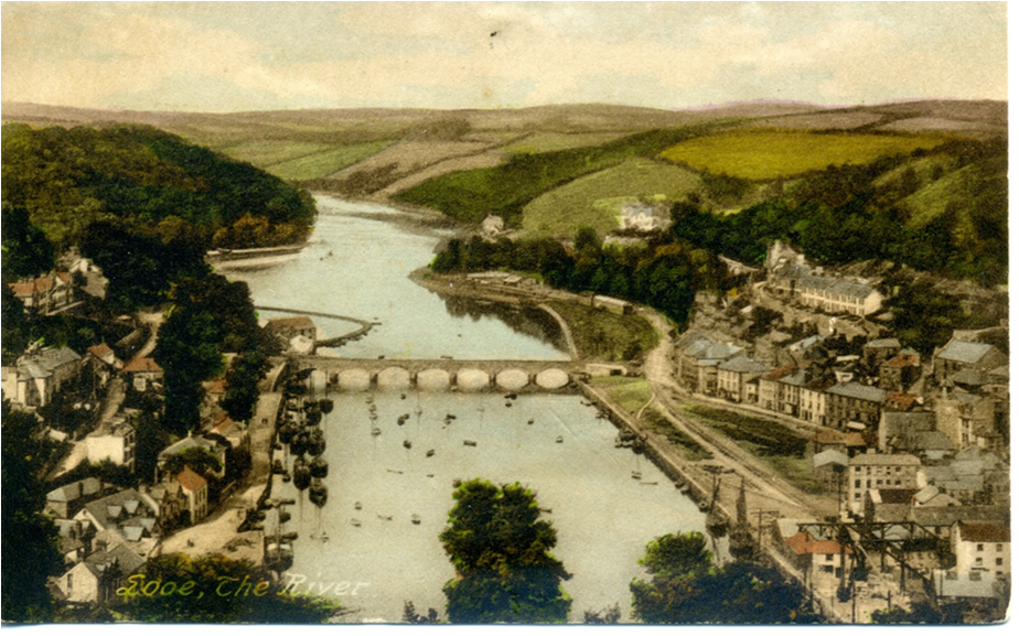
Lecture on Looe
A summary on an excellent lecture given by our member Vicki Baldwin to HADAS on the 12th of October 2021.
The lecture was entitled Looe: A Story of Sea, Sand and Sardines. As I am sure most of you know, Vicki and John moved down to Cornwall and settled in Looe a couple of years ago. Vicki has been exploring and discovering the long history of Looe and this was the subject of her lecture.
Hopefully we will have more lectures as she discovers more about Looe. Here is Vicki’s summary of her lecture for those who did not see it on ZOOM or YouTube.
Looe – a story of sand, sea, and sardines. Vicki Baldwin
My talk was rather a case of trying to cram a quart into a pint pot., and that is the story of Looe really, two towns made into one with a river running through to the sea. It is situated in the South East of Cornwall, about 20 miles from Plymouth.
Essentially, Looe is a Medieval port with both towns being granted charters by Elizabeth I in 1587. East Looe and West Looe had 2 Members of Parliament each until Parliamentary Reform in 1832. It was said “If there is one borough more rotten than East Looe, it is West Looe.”
Until the bridge was built around 1411, the only way to cross the river was by boat or fording it at low tide. As East Looe has a “planned borough” layout, it is thought that the relatively late date for the bridge was due to the original settlement being further up the river away from the optimal bridging point. This would have been a disadvantage for trade as deeper draft boats would not have been able to pass the bridge. 25 years later the bridge burnt down and had to be replaced by a 14 arched stone construction with a chapel to St. Anne in the middle.
Apparently, women wishing to conceive would make a donation to St. Anne in the chapel and then make their way up a steep hill known as Shutta, on their knees, to a well to drink the water.
3
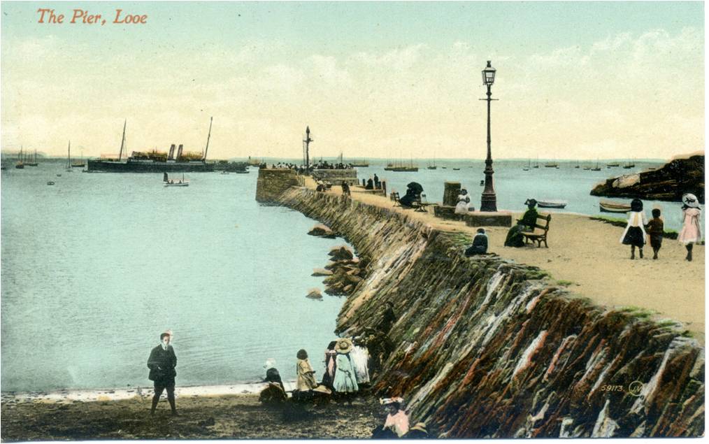
The bridge was narrow with cutwaters each side that created refuges for pedestrians should they encounter carts and livestock. However, by the middle of the prosperous 19th Century, the bottleneck and tailbacks thus created were a threat to trade. Large loads still had to wait for low tide to cross the river further down. In fact, the state of the harbour overall became the subject of a Parliamentary Inquiry in 1846 that resulted in the formation of the Harbour Commissioners in 1848. They still retain control of the harbour area and the buildings there.
The current bridge, the “new” bridge, was built in 1855 by Joseph Thomas Snr., assisted by his son Joseph Thomas Jnr. It is the junior Joseph Thomas who was responsible for creating the layout of Hannafore, the residential and leisure area overlooking Looe Island. Amongst other projects, he was also responsible for the “Banjo Pier” as a way of alleviating the silting problem in the harbour, an innovative design that became widely copied.
And once again I’m trying to overfill the pint pot. I still haven’t mentioned the tidal mill; the various boatyards and boat builders; the fishing industry; the livestock markets; the canal that subsequently became the railway; the bathing machines; the tourist industry; local festivals; Looe or St. George’s Island; The Giant’s Hedge (that we can see from our balcony); imports and exports; raids by the Barbary Pirates; the Shark Angling Club of Great Britain. All have left their marks in the fabric and records of Looe.
One point though, as of now the fish market is still being run from Plymouth, although dayboats and smaller trawlers land their fish in Looe, and locally caught, straight-off-the-boat fish is a feature of several restaurants.
If anyone is down this way, it would be good to catch-up in one of our many excellent (and historic) hostelries.
4
A local clay-pipe manufacturer in Chipping Barnet? By Bill Bass
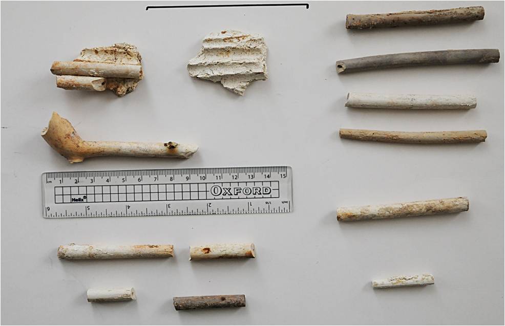
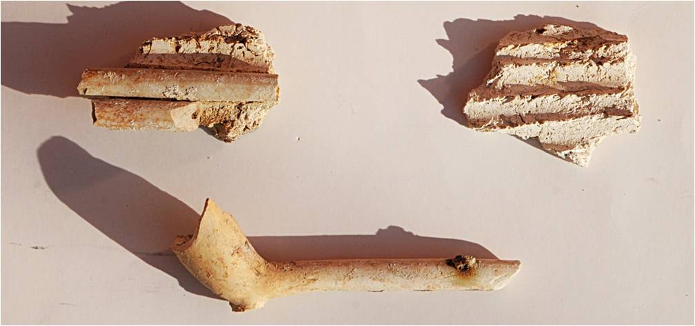
A collection of clay-pipe material was recovered from the spoil of utility works outside of 50 High Street, Barnet in February 2021, there were more but not reachable. They consist of a pipe-bowl of 1700-1770 (Type AO25), some pipe stems and more unusually some fired clay material in a ‘luted’ pattern formed by waster clay-pipe stems impressed in it. These luted fragments are part of a ‘muffle’ (Jacqui Pearce pers-comm). Muffles are used in the firing of finished clay-pipes, they are containers to protect the clay-pipes from direct heat in the kiln a bit like ‘saggars’ are used for a similar job in firing pottery.
5
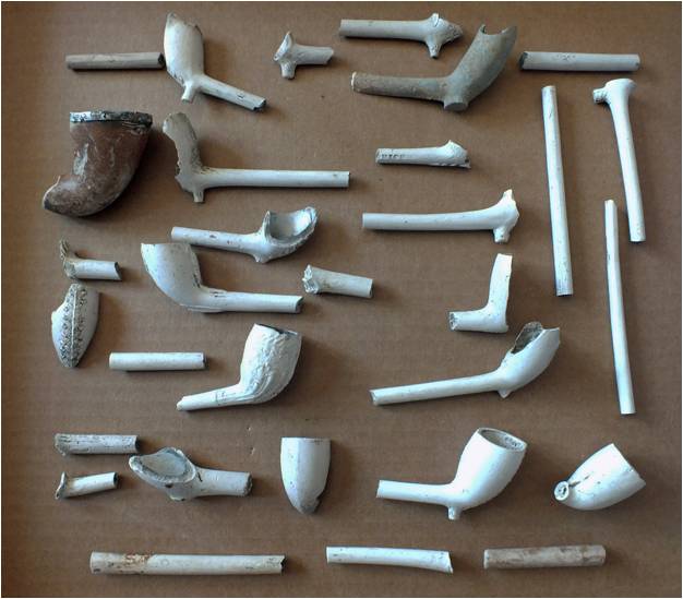
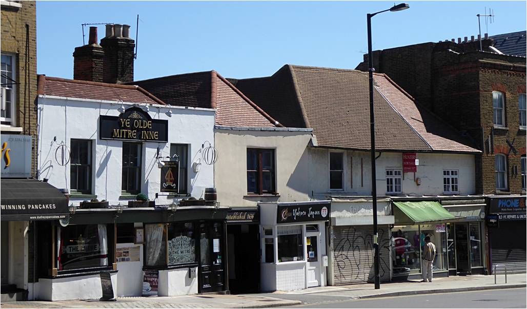
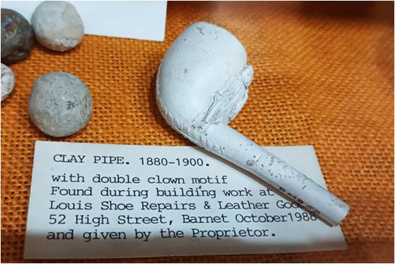
So this raises the possibility that there was a clay-pipe manufactory nearby to 50 High Street. This would not be surprising due to the number of pubs, inns, hostelries and such like over time up and down the High Street. Clay-pipes are a very common find and can be found almost anywhere. They are also very useful for dating purposes as their form and fashion changed quite regularly. Indeed, they have been recorded on excavations near the High Street e.g., the HADAS digs at the nearby ‘Mitre’ pub in 1989-1990 (site code BM89) and at the Old Bull in 1982 (site code OB82) also site-watching at St John the Baptist churchyard (site code CPA 12)1 and other casual finds such as at 93 High Street (see HADAS newsletter 581 Aug 2019) and many other spots in Chipping Barnet. Barnet Museum hold a collection of approx. 66 clay-pipes (many not found in Barnet) with dates spanning the entire period of their use – late 16th to early 20th centuries 2. These are currently held at the Barnet Physic Well 3. The decoration and maker marking of clay-pipes is a wide-ranging subject.
What is not clear or known in Chipping Barnet is the use of ‘small-scale’ production for local consumption, initial inquiries with HADAS sources, trade directories or with Barnet Museum have not turned-up any evidence of local manufacture. Other sources could include census, probate, inventories, and other company records. Many of the clay-pipes found in Barnet are known to have been made in family-based small cottage industries such as in Highgate, pipes are quite often stamped with ‘Andrews of Highgate’ and ‘Harrisons of Highgate’ or similar. Another well-known pipe maker was W. Tingey of Hampstead 4.
6
Some research has been done on these manufacturing centres 5 and 6, but it seems little on any smaller or ‘back street’ areas closer to Barnet High Street (if they existed). Pubs and inns are well known outlets for tobacco pipes, but did they make them as well? The recent discovery of the medieval building at 54A High Street is not far away – what of its subsequent use?
Susan Trackman who has been doing some research in this area comments 7:
Unfortunately, I haven’t got any names (of pipe makers in Barnet). I’ve found nothing in births, marriages, deaths, directories, newspapers or court cases. I’ve looked at the tax records and tried to trace the people in the area close to the finds but I can’t link any names to pipe making. St Albans had a number of makers. I’ve also checked them to see if any of them had links to Barnet but I’ve found nothing to suggest that anyone started out in Barnet. The Bushey maker, John Reynolds, doesn’t appear until the 1850s.
Despite the 70 years allotted to Type 25, I suspect that pipes were made for only a very short period, perhaps even as an adjunct to another business. Whoever the maker, he or she would have been renting their premises probably on a weekly/quarterly tenancy which would suggest only small-scale manufacturing using only a small kiln.
I am sure there were small backyard/basement kilns. In Highgate I have traced at least two pipe-makers (Dawkins and Cleaves) who worked from residential houses and so must have had their kilns in their backyards/basements. I have also found that there were other small operations in Hampstead which, given the locations, could not have had a factory sized kiln. Although more than a century later, Charles Booth (1891; The Labour and Life of the People VOL; page 71) described seeing a kiln fitted into the basement of 19 Parker Street – ” The basement was fitted with a kiln and in the parlour the pipes were made”.
7
Can any members contribute too, or know of any further research? It would add to the knowledge and use of businesses, shops and inns in Barnet.
Sources:
(1) Site Watching at St John the Baptist churchyard, HADAS, Newsletter 500, Nov 2012.
(2) The Journal of Barnet Museum & Local History Society Vol 03, 2019.
(3) Barnet Physic Well (limited opening times), see Barnet Museum website. (Thanks to David Bird)
(4) Andrew Simpson – various HADAS Newsletters.
(5) A Hamlet in Hendon, HADAS: Clay Tobacco Pipes-Smoking and Leisure in Georgian and Victorian Hendon.
(6) The Last Hendon Farm, HADAS: A good pipe of tobacco.
(7) Susan Trackman (pers-comm).
THE ARCHAEOLOGY OF THE HENDON PLATEAU Christopher Sparey-Green
In the last issue of the HADAS newsletter I provided a brief note on the Burroughs place-name in the context of Hendon Grove and Church End Farm. The following provides further background and, firstly, some clarification the use of these names.
The use of the name ‘Burrows’ on the first edition Ordnance Survey map and the use of ‘Burroughs’ on later maps seems confined to the western end of the Hendon plateau, from the present Station Road and Watford Way road-junction to the ridge-top occupied by the Burroughs settlement. Hendon Church, the site of Church End Farm and its dependant settlement lay to the north where the broad road through the Burroughs joins Church End and Church Road, the latter descending to the Quadrant junction with Brent Street and Parson Street. The eighteenth-century Grove or Grove House, later Hendon Grove, lay between the Burroughs and the church and farm at Church End.
The writer’s interest in this area pre-dates the current plans for development on the Hendon Plateau and was prompted firstly by a visit to the sadly now-defunct Church House Museum, then by ‘A Hamlet in Hendon’ and latterly by a revelation similar to Martin Biddle’s when he ‘discovered’ the Aldwych from the top of a 77 bus in 1983 (HADAS Finds Group 2014; Biddle 2014, 14). In my case it was on the recent occasion when I stepped off a 183 bus to be faced with a street sign for ‘The Burroughs’. This immediately posed the question of ‘what burg ‘, having recently been studying Bigbury in Kent and its comparanda in Kent and north of London (Sparey-Green 2021).
8
As highlighted in HADAS Newsletter for November (No. 608) the archaeology of the area is now of some concern in view of the planned development of the Middlesex University Campus. The application for the Hendon Hub Building 9 has been supported by an archaeological assessment by Mills Whipp Archaeological Consultancy (revised July 2021, Historic England CLO 32641), the following summarising complementary data and posing questions as to the wider history of the site.
Topography and Geology
The structure of the Hendon Plateau Is well known but the hydrology of the hilltop should also be considered, the capping of Dollis Hill Gravel over the underlying London Clay creating a perched water table which feeds at least three springs on the hillside at approximately the 75m contour. One on the 1896 25” map just south of Brampton Grove coincides with a combe in the southern hillside shown on the latest 1:25000 map, this watercourse still visible as a culvert on the eastern side of the cutting for the underground line at Hendon Central. To the south the name Gutterhedge Farm on the earliest OS 1” map may refer to this stream at the point close to its feeding into the Brent.
The plateau thus has a good water supply but is also of great tactical significance with communications both south over the high ground of Hampstead and north towards the Brockley hill ridge. In defensive terms it has particularly steep slopes on the north-west and clear views to north and south, the high ground bounded by the Brent on south and east and the Silk River on the west. The former name is significant in view of its likely origin from Brigantia, derived from the name of the Celtic goddess Brigit and applied to tribes and settlements in Britain, Ireland and Spain. In such a location the place-name ‘Burroughs’ or ‘Burrows’ is surely significant and suggests some defensive works on the plateau which may yet survive on the north and west. The northern edge of the grounds of Hendon Grove, now incorporated within the University, is delimited by a possible earthwork up to 1.5m high and perhaps 5m wide, a hollow on the downhill side its silted ditch, this coinciding with the break in slope on that side of the plateau. The north boundary to the grounds of St Joseph’s Convent school could represent its continuation to the Watford Way, beyond which the contour- following water feature shown on the 1896 25” map bounding Burroughs Lodge could be its continuation, returning to the south but now erased by pre-war development beyond the Watford Way.
The name ’Church End’ itself begs the question as to what ended at that point, not the ridge nor perhaps the Saxon and Medieval settlement which would be expected to focus on the church, a possible minster. The implication is that the latter was situated at the eastern end of the Burroughs. The early estate maps reproduced in ‘A Hamlet’ (Fig 28) also show the existence, in the field south of the Church End Farm site, of an L-shaped pond. This is a recurrent feature on the plans of the eighteenth to twentieth centuries and was still extant in 1937, the area now occupied by trees and scrub between the University buildings and Church End. Elsewhere such ponds are the remnants of moated sites, such a site here the focus of the medieval settlement, as implied by the name Hall Field. Hendon Grove to the south could then have replaced it.
Archaeology
In assessing the archaeological potential the area investigated and the extent to which intact stratigraphy has been identified and sampled to bedrock needs to be taken into account. In very general terms, access to intact areas of the Hendon plateau has necessarily been limited but the Church End report (HADAS Finds Group 2014) and other investigations have recovered a surprising quantity of Roman and later Saxon pottery, not to mention the medieval remains. Prehistoric finds have been limited but for the Roman period the presence of Roman tile including a fragment of box-tile, may indicate a substantial building (HADAS Newsletter No. 594, September 2020, 2-4). The report of a mosaic pavement in the Burroughs raises the possibility of a Roman temple at this end
9
of the hilltop, the church later established at a distance to its east.
The Saxon occupation is notable for the lava quern fragments, a significant find suggesting a site of some status with material imported from the Rhineland via the Thames side trading site in the Aldwych (Vince 1990, 97, 135). The spiral headed pin is also a particularly fine specimen of the metalwork of the period.
This brief overview of some aspects of early Hendon has implications for the archaeology of the area under consideration for development and points out the scope for further research and investigation by HADAS. The Church End report and others produced by HADAS highlight the importance of the area and the longevity of activity on this prominent hill, the defensive potential of which has already been noted (Taylor (ed.) 1989, 35).
Bibliography
Biddle, M., 2014, the Road to Lundenwic in Cotton et al. (eds.), ‘Hidden Histories and Records of Antiquity’, Essays on Saxon and Medieval London for John Clark, Curator Emeritus, Museum of London, London and Middlesex Archaeological Society Special Paper 17, 13-16.
HADAS Finds Group, 2014, A Hamlet in Hendon, The archaeology and history of Church End, from excavations at Church Terrace 1973-74, Hendon and District Archaeological Society.
Mills Whipp 2021, Hendon Hub Regeneration, Building 9, The Burroughs, London Borough of Barnet NW4 4BT, Desk-based Assessment: Archaeology, millswhipp@yahoo.co.uk
Sparey-Green, C., ‘Bigbury Camp and its associated earthworks: recent archaeological research’, Archaeologia Cantiana 142, 31-58.
Taylor, P., (Ed), 1989, A Place in Time, Hendon and District Archaeological Society.
Vince, A., 1990, Saxon London, An Archaeological Investigation, The Archaeology of London, Seaby London.
The Friends of Highgate Roman Kiln (FoHRK) Eric Morgan
crowdfunding campaign to rebuild a Roman pottery kiln.
FoHRK have the intention to rebuild a Roman pottery kiln found in Highgate Woods to display it in an education centre for schools and local communities.
In 1966, archaeologists Tony Brown and Harvey Sheldon (HADAS President) and their team spent several summers excavating the substantial Roman pottery manufacturing site which they found in the woods.
The site revealed the remains of some 10 pottery kilns and a large quantity of pottery wasters. Kiln 2 lifted in 1968 was remarkably well preserved. Investigations showed that pottery had been made at the site periodically between c.AD50 and c.AD130/160. Kiln 2 was cut out into 18 pieces and moved for conservation to the Horniman Museum in South London and then in 1990 to Bruce Castle Museum in Tottenham, where it is now in storage. One piece of the kiln is in the information centre in Highgate Wood. During July 2021 FoHRK launched their campaign. The partners are (Trustees) Catherine West MP, Harvey Sheldon, Michael Hammerson, Nick Peacey (Secretary) and Charlie Andrew. The City of London Corporation (Owners of Highgate Wood), Highgate Wood team,
10
Bruce Castle Museum, the Museum of London and Classics for all. The patrons are Huge Dennis and Clare Skinner.
This is a very worthwhile project which we should all be supporting.
Do go on the FoHLK website www.highgateromankiln.org.uk to view future plans and events. To contribute financially, the Just Giving site can be found at www.justgiving/campaign/kiln2021
They need to raise £250,000, starting with an initial target of £25,000 , over half of which was raised by August.
Other Societies’ events by Eric Morgan
Thursday 2nd December, 8pm. Pinner Local History Society, Village Hall, Chapel Lane Car Park, Pinner, HA5 1AB. “A Boy’s memory of Pinner in the years after 1945”. A talk by Phillip Snell. Please visit www.pinnerlhs.org.uk
Saturday 4th December, 10.30am to 12.30pm. Hornsey Historical Society, The Old Schoolhouse, 136 Tottenham Lane (cnr. Rokesly Ave.) N8 7EL. Local History Surgery. If you need help or advice with a local history project contact John Hinshelwood on 07531866714 or email hornseyhistoricalsurgery@gmail.com . Appointments are not essential, but it is helpful if you can book in advance.
Sunday, 5th December , 2.30pm. Heath and Hampstead Society, meet at Kenwood (off Hampstead Lane, NW3 7JR) at the Old Kitchen Garden. “ The hidden heath and it’s archaeology , walk led by Michael Hammerson (Highgate Society), lasts approx. 2 hrs. Donation £5. Please contact Thomas Radice on 07941508084 or email hhs.walks@gmail.com. Or visit website at www.heathandhampstead.org.uk
Sunday 5th December. Barnet Xmas Fayre, Stalls and performers in the high street, the Spires, The College (Wood Street) and The Bull. For full programme please visit www.barnetarts.uk
Tuesday 7th December, 1pm. Society of Antiquaries. The mirror in the bike shed; a listed Arts and Crafts bicycle shed in Hampstead Garden Suburb, its significance for women bicyclists. Talk on ZOOM by Anthony Davis (FSA). Book at https://tinyurl.com/23rs44v4
Wednesday, 8th December, 2.30pm. Mill Hill Historical Society, Trinity Church, 100, The Broadway, NW7 3TB. “The Treasures in our Archive”. Talk by Dr Richard Bingle (President). Please contact www.millhill-hs.org.uk
Friday, 10th December 8pm. Richmond Archaeological Society. Talk on ZOOM. Barn Elms, Going to town on an Iron Age oppidum? By Michael Curnow (MoLA) For login link, please email stephen alexander at alexander.stephen@gmail.com. (You made be asked for a donation.)
11
Tuesday 14th December 6.30pm. LAMAS. “Where practice trenches meet Roman ditches = Roman versus Wartime archaeology” at Royal Library School, Havering. Talk on ZOOM by Helen Chittock and Les Capon (AoC Archaeology). Book at www.lamas.org.uk/lectures.html.
Acknowledgements
With many thanks to this month’s contributors: Vicki Baldwin, Bill Bass, Stephen Brunning, Eric Morgan, Jim Nelhams, Peter Pickering and Christopher Sparey-Green
______________________________________________________________________________________________________________________________________
Hendon and District Archaeological Society
Chairman Don Cooper 59, Potters Road, Barnet EN5 5HS (020 8440 4350)
e-mail: chairman@hadas.org.uk
Hon. Secretary Vacancy
e-mail: secretary@hadas.org.uk
Hon, Treasurer Roger Chapman, 50 Summerlee Ave, London N2 9QP (07855 304488)
e-mail: treasurer@hadas.org.uk
Membership Sec Stephen Brunning 2 Goodwin Court, 52 Church Hill Road, East Barnet
EN4 8FH (0208 440 8421) Please note new flat number
e-mail: membership@hadas.org.uk
Join the HADAS email discussion group via the website at: www.hadas.org.uk
12