Due to the COVID-19 pandemic, until further notice lectures will be held online via ZOOM, all starting at 8 pm. Apologies to those who are unable to see online lectures. We will be sending out an invitation email with instructions about how to join on the day of each talk. Keep an eye open for them!
Tuesday 9th November – The Gask Ridge – recent work at Rome’s Northernmost frontier. Lecture by Dr Birgitta Hoffman. This frontier system is the earliest Roman land frontier in Britain, built in the 70s or 80’s AD, 40 years before Hadrian’s Wall and 60 years before the Antonine Wall. The Lecturer is one of two Directors of the Roman Gask Project, now an Independent Research Organisation based in Manchester. This replaces the lecture previously arranged on Battlefield Archaeology: Barnet 1471 which the lecturer Sam Wilson has had to cancel for family reasons.
The Burroughs – place nameby Christopher Sparey-Green
HADAS members will no doubt be interested in the proposed development in Hendon on the Middlesex University Campus, adjacent to Church End, the site of the HADAS excavations in the 1970s (A Hamlet in Hendon, The archaeology and History of Church End, from excavations at Church Terrace 1973-74, HADAS Finds Group, 2014). Leaving aside considerations of the nature of the proposed development and the objections to this, the following is simply to draw attention to the archaeological potential of the area.
The Church End report highlighted the importance of the area and the longevity of activity on this prominent hill, the defensive potential of which was emphasised in another HADAS publication (A Place in Time, Pamela Taylor ed., 1989, HADAS, p. 35). Topographic considerations are emphasised by the place-name of the ‘Burrows’ on the first edition Ordnance Survey map and the use of this term for a defended site or earthwork on the early 25 inch maps.
In the area of the Hendon War memorial junction, on the west of the hilltop, there was the site of Buroughs Farm and Boroughs Lodge, the early settlement towards Church End collectively ‘The Burroughs’. Furthermore, the series of early estate maps reproduced in ‘A Hamlet’ (Fig 28) show the existence of an L-shaped pond adjacent to the Church End Farm, this still extant in 1937, such ponds elsewhere the remnants of moated sites. Finally, a walk-over of the adjacent park within the University grounds, once the gardens of Hendon Grove, suggests the existence of a much denuded but substantial earthwork along its northern, downhill side. A potential westward continuation can be seen in the northern boundary of St Joseph’s Convent and, beyond the Watford Way, in the one-time curving boundary of the Burroughs Lodge, now lost under pre-war housing. There are some serious implications for the archaeology of the area under consideration for development and scope for further research and investigation by HADAS.
1
Barnet Medieval Festival by Don Cooper
Barnet Medieval Festival took place on 11th & 12th September 2021 at Barnet Elizabethans Rugby Football Ground. The belated celebration was for 550th anniversary of the Battle of Barnet which fell on 14th April 2021. The weather was fair and warm. There was a large attendance on both days both re-enactors and visitors as you can see from the photo below.
Figure 1 Witnesses to the battle. Photo by Melvyn Dresner
HADAS manned a stall there on both days and we were kept busy with lots of public interest.
Figure 2 Busy at the stall. (Photo by Robin Densem)
2
As well as asking about HADAS and what we do, the two main topics of interest were (1) the recent discovery that 54a Barnet High Street is dated by dendrochronology to the mid-14thc and what was going to happen to it (2) the proposed Hendon Hub, which is contentious for the local Hendon residents.
Figure 3 Robin in full flow. (Photo by Melvyn Dresner)
We gave out lots of HADAS membership application forms in the hope that it will bring in some new members.
I would like to thank the members who came along in support and those committee members who helped to man the stall especially Melvyn Dresner who was with me for the whole two days.
Battle of Barnet Arrowheads and Earl of Warwick Seal by Bill Bass display at Barnet Museum
This remarkable collection of six arrowheads and a seal of the Earl of Warwick are currently on display at Barnet Museum. The objects are part of the British Museum collection and have been used by them as part of several European exhibitions and latterly at the National History Museum in Ottawa, Canada, the exhibition was called ‘Medieval Europe: Power and Legacy’.
Since then, Barnet Museum has negotiated for the finds to be shown in their home town. These are displayed along with several other objects from Barnet’s battlefield collection including 3 lead cannonballs, a purse bar, a coin of 1468 and a decorated strap-end.
The arrowheads were bought on behalf of the British Museum from a Mr John Doubleday in 1851. Unfortunately, apart from the British Museum’s acquisitions register which states ‘These were all found on the battle-field at Barnet’ (1471) there is no further location spot or provenance. They do however date to the late 15th century, made of iron, they range from narrow-barbed to more flared or broadhead barbed types. They compare well with other known surviving arrowheads and with contemporary paintings and documents. They are also a similar form to those recovered from Towton battlefield (1461) and others from the British Museum and Museum of London.
3
A selection of the arrowheads (image British Museum).
The seal was originally donated to the British Library in 1774, then to the British Museum in the 1830s. It was donated by Mrs Victoria Kynaston whose ancestor Sir Roger Kynaston (1430-1495) fought at the Battle of Barnet on behalf of Edward IV and was said to have recovered the seal from the Earl of Warwick’s body. It is 9.60cm in diameter, cast in brass with a loop at the bottom and has a Latin inscription and image of a mounted knight with sword and shield.
Seal of the Earl of Warwick (image British Museum).
4
A selection of replica arrowheads from the Barnet Medieval Fair 2021 (image Andy Simpson).
Armour, long bows and arrows from the Barnet Medieval Fair 2021 (image Andy Simpson).
Archers prepare for battle at the Barnet Medieval Fair 2018 (image Bill Bass).
5
The display at Barnet Museum is well worth a visit and if the finds are correct, show that there is the possibility of finding more objects to pinpoint the actual battle location.
Sources: Much of the information above is taken from The Journal of Barnet Museum & Local History Society, Vol 5 (2021) Hilary Harrison.
The Barnet battlefield project 2015-2018, University of Huddersfield.
It would be wise to check and confirm the details with the particular society before travelling to these events
Thursday 4 November – online event -HISTORY DAY
History Day is a day of online interactive events for students, researchers & history enthusiasts to explore library, museum, archive and history collections across the UK & beyond.
This year the theme is environmental history and will explore collections that capture the experiences of ordinary people, collectors and scientists, looking at nature, landscape, climate change and much more. Over 50 libraries, museums, archives and history organisations across the UK and beyond will come together online to share collections and resources. Join us and collaborators across the globe to explore these collections with two interactive sessions, a lunchtime livestream and a wide variety of content featured in our Discover Collections Gallery. To book use the following link – https://sas.sym-online.com/registrationforms/ihrbooking_42478/done/ For more information, go to the History Collections website and make sure to follow the hashtag #HistDay21 on social media.
6
Monday 8th Nov at 6pm – 7.30pm.London Archaeological Forum will be hosted as usual by CBA London, Free to attend, online by Zoom There will be 4 presentations.
Holywell Priory (Shoreditch) – Matt Edmonds, Pre-Construct Archaeology, on the findings of recent excavations that revealed a medieval priory church and the extensive associated cemetery. Black Death and minorities – Dr Rebecca Redfern, Museum of London, on the results of a large research project examining the skeletal remains from cemeteries used during the Black Death. Blossom Street – Alison Telfer, MOLA, on excavations just north of Spitalfields that included late Iron Age horse remains, Roman burials, medieval walls linked to the St Mary Spital precinct, Tudor ovens, and remains from 17th to 19th century buildings fronting Norton Folgate. Arch-I-Scan – Prof Penelope Allison, University of Leicester, on the project to use automated recording and machine learning for cataloguing and collating millions of Roman ceramic tableware remains, a new approach that will enable the investigation of eating and drinking practices, rather than just production and trade.
Sat 13th November from 9.45am to 4.00pm.LAMAS Conference to be held online via Zoom This year’s theme is ‘London Overcomes: Resilience and Recovery in the History of the Capital’. Further details on their website at http://www.lamas.org.uk/conferences/local-history.html The programme is as follows: 10.15 – 10.45 -Session 1 ‘Lost angels of a ruin’d paradise’, Dr Peter Coles 11.00 – 11.30 -Session 2 ‘Casualty Services and Civil Defence within London’, Nathan Hazlehurst 11.30 – 11.45: Tea break 11.45 – 12.15: Session 3 ‘Shamefaced No More: Pauper Letter Writers, Resilience and the Workhouse Experience in Poplar and Bethnal Green, ca.1860-1890’, Dr Peter Jones & Professor Steven King 12.30 – 13.00: Session 4 ‘The Brentford Flood of 1841’, Val Bott 13.00 – 13.45: Lunch break 13.45 – 14.15: News and Updates from Local Societies 14.15 – 15.00: Keynote Lecture: ‘Modernist Visions vs. Reality in Postwar Rebuilding’, Dr Catherine Flinn 14.45 – 15.00: Tea break 15.00 – 15.30: Session 5 ‘Who hid the Cheapside Hoard?’, Dr Rosemary Weinstein 15.45 – 16.00: LAMAS Publication Awards for 2019/20 and 2020/21 To book a ticket go to Eventbrite. https://www.eventbrite.co.uk/e/lamas-local-history-conference-london-overcomes-tickets-177950172757
Other Groups London and Middlesex Archaeological Society (LAMAS) Tues 9 Nov. 6.30 pm. The Enfield Archaeological Society & Elsyng Tudor Royal Palace. Talk by Martin Dearne (EAS) Fieldwork research Director held on Zoom. Book at www.lamas.org.uk/Lectures.html
7
Mill Hill Historical SocietyWed 10 NovSecret London 2.30 pm. Talk by Mike Beach. Trinity Church, The Broadway, London NW7 3TB. www.millhill-hs.org.uk
Ruislip, Northwood and Eastcote Local History SocietyMon 15 NovLost rivers of London. 8.15 pm. Talk by Dr. Tom Bolton held online. Check website www.rnelh.org.uk for login closer to the date.
Friern Barnet & District Local History Society website or telephone 020 8368 8314 Wed 24 NovBeautiful Britain talk by David Berguer 8.00 pm North Middlesex Golf Club, The Manor House, Friern Barnet Lane, N20 0NL Please arrive early (7.45 pm) as checking in will take longer than usual due to new restrictions. Refreshments can be purchased at the Club Bar. £2.00 for non-members.
Finchley SocietyThurs 25 NovGreen update talk by Peter Hale (Chair of Environment and Transport Committee) & Paul Salman (same committee) – 7.30 pm Drawing Room, Avenue House, 17 East End Rd, N3 3QE. Non-members £2.00 at the door. Also on Zoom. Visit www.finchleysociety.org.uk for Zoom link
Museums
Science Museum, Exhibition Road, SW7 2DD Open Wednesday to Sunday, 10.00–18.00 Free exhibition Ancient Greeks: Science and Wisdom 17 Nov. 2021 to 5 June 2022. Ticket required.
British MuseumPeru: a journey in time. From 11 Nov. 2021 – 20 Feb. 2022. Adults from £15, Members and under 16s free. The exhibition will include ceramics, precious metals, textiles and ritual paraphernalia from the BM as well as loans from Peru.
Hon. Treasurer Roger Chapman, 50 Summerlee Ave, London N2 9QP (07855 304488) e-mail: treasurer@hadas.org.uk
Membership Sec Stephen Brunning 2 Goodwin Court, 52 Church Hill Road, East Barnet EN4 8FH (0208 440 8421) Please note new flat number e-mail: membership@hadas.org.uk
Join the HADAS email discussion group via the website at: www.hadas.org.uk
Please note that until further notice all HADAS lectures will be held online via Zoom due to coronavirus. We will be sending out an invitation email with instructions about how to join on the day of each talk. Keep an eye open for them!
Tuesday 12th October
Vicki Baldwin
Looe: a Story of Sea, Sand and Sardines
Tuesday 9th November
Sam Wilson
Battlefield Archaeology: Barnet 1471
Some forthcoming lectures from other societies (I think it would be wise to check and confirm the details with the particular society before travelling)
Wednesday 13th October, 2.30pm. Mill Hill Historical Society at Trinity Church, 100 The Broadway NW7 3TB. John Norman: The Organ, this magnificent instrument and its history
Wednesday 27th October, 7.45. Friern Barnet & District Local History Society at North Middlesex Golf Club, The Manor House, Friern Barnet Lane, London N20 0NL. Dorrell Dressekie: An Act Of Faith: The Story of North London Hospice. Non-members £2
Thursday 28th October, 7.30pm. Finchley Society at Avenue House (Stephens House), 17 East End Road, Finchley, London N3 3QE. A special meeting to commemorate the Finchley Society’s 50th Anniversary> Non-members £2 at the door, and also on Zoom.
LEGACY for HADASDon Cooper
I was delighted, on behalf of HADAS, to receive in the post a cheque for £500. This unexpected gift has come from the estate of Denis Ross, a former long-term honorary secretary of HADAS. I am sure many of you will remember Denis and wife Shifra from the many HADAS outings and events they attended.
1
Some 19th century and later images and map extracts showing monuments and views around Marble Arch, Hyde Park Corner, and Buckingham Palace.Robin Densem
This article locates and illustrates some of the visible, standing monuments at and near Hyde Park Corner in the City of Westminster in Central London. Not all the visible remains are mentioned or illustrated, there are just too many!
George IV (1820-30) had wanted to make Buckingham House, as it had been called, into a palace. The original part of the house dated from 1702-3 was aligned north-south and had been built by the Duke of Buckingham, as a country house on the west edge of London, facing down The Mall. The house was bought in 1762 as a family retreat for George III’s Queen Charlotte and it became her chief home and the house was extended over the next 20 years. George IV wanted to turn the enlarged house into a palace and this work began in 1825 under his architect John Nash.
2
The building work and additions were incomplete when George died in 1830. More work resulted in a deep forecourt projecting east from the original eighteenth century north-south block that itself had been heightened and extended. The forecourt was enclosed to north and south by wings projecting eastwards from the original extended block. The east side was closed off with railings and a formal gateway, the gleaming white Marble Arch of 1827-33. A new eastern wing was built in 1846-50 to form the present rectangular building, and the new wing necessitated the removal of the Marble Arch to its present location at the north-east corner of Hyde Park, in 1851. The east wing holds the famous balcony, looking east, and where the Royal family can be viewed these days.
Alongside Royal desires to have a palace to rival those elsewhere in Europe, there was also a need to express patriotic pride in the achievements of the Duke of Wellington in the Napoleonic Wars that culminated at Waterloo in 1815. He had bought Apsley House in 1817 and held annual dinners there with surviving officers from the wars.
3
At Hyde Park Corner George IV wanted “some great ceremony outwork that would be worthy of the new palace that lay to its rear” (William Guy, 1990, Augustus Pugin Versus Decimus Burton, 50). Two monuments were built in 1826-9, the Wellington Arch, to celebrate his and British victories, and the Hyde Park Screen, and both to enhance the approach to the palace.
4
5
6
7
8
9
Conclusion
I had intended to make a study of 20th century war memorials in Barnet, but I was overcome by the power of the grand monuments and war memorials in and around Hyde Park. If one has the time, and the money for the admission charge, then a visit to Apsley House is wonderful if one wants to see an internationally important collection of paintings, silver and porcelain. Many of the items were presented to the 1st Duke of Wellington after Waterloo. He held annual dinners there with his surviving comrades to commemorate their victory at Waterloo in 1815. The Wallace Collection is not far away, and features free admission! Apart from Apsley House, the external elements of the monuments touched on above are all freely visible, in the open air, and a walking tour could make for an interesting excursion. And, of course, the exterior of Apsley House can also be seen. And there are other monuments in Hyde Park that could also be explored while a walk down Constitution Hill to Buckingham Palace would round off the trip!
10
Ground level photo looking north-west at the Mound and the Marble Arch (author, 19.9.2021).
Acknowledgements: I am grateful for help from English Heritage. Jim Nelhams and Rosemary Yeaxlee very kindly copy edited the article. Jim also provided much patient help in the latter stages, and I am very grateful to him. However, all errors are mine.
Postscript: Since writing the article in March 2021, Jim kindly reminded me of the Marble Arch Mound, a free admission attraction by Westminster City Council that opened on 26th July 2021 and that will close on 9th January 2022. “ Commissioned by Westminster City Council, the Marble Arch Mound is a temporary landscape installation that brings a renewed excitement about the area and manifests the council’s vision of a Greener, Smarter, Future, Together.” (https://osd.london/marble-arch-mound/ accessed 19.9.2021).
Due to the COVID-19 pandemic, until further notice lectures will be held online via ZOOM, all starting at 8 pm. Apologies to those who are unable to see online lectures.
Tuesday 12th October
Vicki Baldwin
Looe: a Story of Sea, Sand and Sardines
Tuesday 9th November
Sam Wilson
Battlefield Archaeology: Barnet 1471
It is nice to see other groups opening up, with Eric Morgan’s compilation of “Other Societies’ Events” making a welcome return to our newsletters.
———————————————————————————————————
Another Boundary MarkerDudley Miles
Following the articles in the February and March newsletters on boundary markers in Barnet, Hugh Petrie, the Barnet Council Heritage Development Officer, has kindly informed me of another one.
It has been discovered buried by the bridge over Mutton Brook at Henlys Corner and reinstalled in its proper place. The brook forms the boundary between the ancient parishes of Hendon and Finchley. The stone boundary marker is inscribed ‘F.P. [Finchley Parish] 1846’.
This is the oldest dated marker I have come across.
1
East Finchley HADAS dig uncovers an intriguing bottleStewart Wild
The HADAS dig at East Finchley’s Market Place over the weekend of July 17–18 revealed a number of interesting bits and pieces, mainly Victorian – see report elsewhere. When I visited on Sunday morning our chairman showed me a small rectangular glass bottle about 4½ x 2x 1½ inches that had just been brought to light. Although any label had long gone, embossed in the glass were the words Kutnow’s Powder.
I found this intriguing as I had never heard of such a product, so when I got home, I decided to investigate and as usual Google was most helpful.
Kutnow’s Powder was marketed by a Victorian company which seems to have started in Leeds. Its registered address in London was 41 Farringdon Road, a site near Farringdon station now occupied by a post office.
The product, very popular it seems, had something in common with today’s Alka Seltzer and was effervescent. It was claimed to solve all sorts of medical problems and sold (1900–10) for two shillings and ninepence (equivalent to around £16 to £18 in today’s money) so was almost certainly a rip-off.
A full-page Daily Telegraph advertisement in April 1918 offered free samples and claimed that a dose of the famous powder before breakfast results in “a spring cleaning of the alimentary and urinary systems, reinforced Health and Strength and an abundance of Good Spirits.” There was a spurious historical link to European spas and a town in Poland although it was described as “The Famous British Remedy Made in England Only”. It was proudly supplied to a number of military hospitals which was important when World War I was still raging.
I found several similar Kutnow’s bottles on sale on eBay, mostly for around £10. Also on sale for rather more was a 1902 postcard advertising the powder by Kutnow Bros Ltd with an address at 853 Broadway, New York City.
The company had worldwide sales agents and was obviously very successful for many years. In Britain the company titled S Kutnow and Co Ltd was formally wound up in May 1965.
———————————————————————————————————
The Archaeology of Household ProtectionDavid Willoughby
We think of archaeology as being associated principally with the excavation of sites buried underground to discover information about how people lived in the past. However, there is little known branch of archaeology that is primarily associated with objects and features that are above ground level and that is the archaeology of household protection.
In the past people had a strong belief in the existence of evil spirits and witchcraft and these beliefs lingered on well into the twentieth century and perhaps beyond. They therefore felt a strong need to protect themselves, their dwellings and religious buildings from the potential harm that could done to them by these malign influences. This protection included:
‘Witch’ Bottles
Usually concealed at an opening through which an evil spirit or witch might enter (usually the hearth or chimney), these were often anthropomorphic bellarmine jars dating from the 16th-17th C. These usually contained bent nails or pins (to impale the evil spirit) and items like urine, nail clippings or hair (designed to lure the spirits to the bottle instead of to the intended victim).
3
Bellarmine jar ‘witch’ bottle with contents (Museum of Witchcraft)
Shoes
Worn shoes were often deposited in the chimney breast, or roof spaces of buildings. These were intended to lure an evil spirit to the shoe rather than to its former wearer. They are usually found as single shoes so that the evil spirit wouldn’t run off with them! Hoards of shoe deposits have been found with individual shoes dating from a period extending over two-hundred years.
Mummified Cats
Mummified cats are often found in chimney breasts, roof voids or even in wall spaces. Although some may be the result of a live cat crawling into a space from which it couldn’t escape, it is clear that many are found in places where they could only have been placed (hopefully whilst dead) – for example bricked up in walls. It is thought that people believed that cats being alert creatures and active at night would offer protection from evils spirits that might enter the house whilst the occupant was asleep.
Apotropaic (‘Witch’) Marks
These are marks on the wooden beams, doors etc. that are designed to offer protection. They can be found in a variety of old buildings, especially churches and older National Trust properties. The three most common types are, burn marks, daisy-wheels (hexafoils) and Marian marks but there are others.
Burn marks were once thought to have been accidentally caused by candles but research has revealed that these could only have been deliberately made (even in some cases before the building was constructed). It is thought that they either offer protection against evil spirits
4
with the flame lighting dark places where they might lurk or as a protection against lightning strikes (in the belief that lightning never strikes twice in the same place).
Burn marks in Haddon Hall, Derbyshire
Daisy-Wheel Marks are thought to represent the sun with the idea that they light up dark parts of the building where evil spirits might lurk.
An example of a daisy-wheel (hexafoil) apotropaic mark
5
Marian Marks are especially common in churches. In the form overlapping ‘V’s, they are thought to represent the initials of the Virgin Mary so that she might be invoked to protect the building.
There are other forms of household protection and examples of household protection can be found throughout Europe, the eastern seaboard of America and in Australia. Many examples can be viewed in local museums and finds are still coming to light dating from as late as the twentieth century. It is fun looking around National Trust properties like Ightham Mote to spot the burn marks!
———————————————————————————————————
The Colindale Locomotive – ‘Trym’Andy Simpson
This locomotive was built in 1883 by Hunslet Engine Company as their works number 287, and it is one of the two oldest surviving locomotives which they made which is preserved in Britain (Works No 243 which was built in 1880 is preserved in Spain). It was made for the Cardigan Ironstone Company (later Stewarts and Lloyds) who had opened new quarries near Corby and named it ‘Vigilant’ and delivered to them on 2 November 1883.
6
Vigilant/Trym is a typical example of a small contractor’s locomotive, built for use on the light temporary trackwork of construction sites and railway works, and weighs just 12 tons 7 cwt.
The locomotive had wooden buffer beams, wooden brake blocks and other features such as a hinged flap smokebox door which although an improvement on earlier pioneers, would have been considered outdated even at the turn of the 20th Century.
In 1903 the company disposed of its four-coupled engines and this locomotive was sold to Whitaker Brothers, a public works contractor from the West Riding of Yorkshire. The locomotive was very soon sold again, however, being purchased by Harold Arnold and Son of Doncaster, who used it in the construction of the small Embsay Reservoir near Skipton, Yorkshire, between 1905 and late 1909.
Very little is known of what the loco’s use over the next few years, other than that in 1919 the engine was rebuilt, and in 1920 sold to Nott, Brodie and Co. Ltd of Northampton. It is believed that the name Trym was acquired in about 1922 when it was one of several locomotives employed on an unemployment relief scheme – the construction of the five-mile long Bristol – Avonmouth Portway road, the River Trym being a small tributary of the River Avon which the Portway crosses on a six-arch viaduct which also spans the remains of a Roman harbour and small town, Portus Abonae (Sea Mills), seemingly abandoned by the late 4th century AD. Part of the Roman Settlement of Abonae, Non Civil Parish – 1408558 | Historic England
The early 1930s saw Trym under the ownership of Sir Robert McAlpine and Sons Ltd, working on the Otterspool sea wall contract for Liverpool Corporation, this being constructed on the River Mersey 1930-32.
Another change of ownership occurred in March 1940 when Howard Farrow Ltd of Hendon purchased the locomotive and it entered our particular area of interest.
Howard Farrow were quite a major civil engineering/public works contractor, working on roads, sewers/drainage and new estates, including Hemel Hempstead new town and trunk roads in the London Colney/Potters Bar area. In the early 1920s they had widened and reconstructed Station Road, Hendon, on behalf of Hendon Urban District Council, laying wood blocks on a steel-reinforced reinforced concrete foundation, as proudly shown in their advertisement in a Hendon guide at the time.
7
A second rebuild followed around 1942 when Trym was fitted with a new firebox and boiler. In 1943 Trym was used for the construction of a new marshalling yard, known as Riverside Yard, north of Exeter St. Davids station, and goods relief lines at Exeter on the Great Western Railway, to help cope with increased wartime freight traffic.
It is thought that the engine may have been on hire to the Ford Motor Co. at Dagenham, Essex, in 1954, although to date, no proof has been found to substantiate this.
In fact it is possible that the engine may not have worked at all after 1947, when one of two known published photographs of it were taken, and it stood in open storage for some 17 years on a short length of track on an embankment near Silkstream Junction and visible from the northbound tracks on the Midland main line from St Pancras to Bedford and also visible from Colindeep Lane, bearing the rather weathered painted inscription on its tanks ‘Howard Farrow Ltd Civil Engineering & Building Contractors London-Bristol’. It was kept alongside other items of contractor’s plant including a steam crane, bulldozers and scrapers.
8
As former local resident Brian Down explains;
As far as I recall you wouldn’t be able to see it from the (Colindeep Lane Railway) bridge, the entrance to Howard Farrow’s yard was approximately where the current entrance into the industrial units is, immediately to the right of North London Grammar School.
The loco was at the back of that entrance road facing towards Colindeep Lane & raised up above the road level by a few feet on some sort of platform, presumably to allow it to be moved directly onto a lorry for transportation. The Northern Line was beyond that. Photo in Colindale in 1962 –
A short article and photograph appeared in the July 1963 edition of the Railway Magazine which mentioned that Trym was for sale, preferably to serious preservationists, as the firm informed the Edgware Railway Society. As a result it was purchased by David Alexander, a Quainton Railway Society member who owned several items of historic rolling stock, and after initial storage at the London Railway Preservation Society’s Skimpot Lane depot in Luton (a one-time Government Ministry of Supply cold storage Depot) from May 1964, it arrived at Buckinghamshire Railway Centre at Quainton in April 1969 and was stored partly dismantled.
In November 1989 Trym was sold and moved to the Northamptonshire Ironstone Railway Trust at Hunsbury Hill, where the locomotive was renamed Vigilant. In September 2010 the Northamptonshire Ironstone Railway transferred the locomotive to the Rutland Railway Museum at Cottesmore to restore the locomotive.
The locomotive moved to Cottesmore in September 2010 and by July 2011 Vigilant was back on its wheels with overhaul underway. Replacement seasoned oak buffer beams were cut to size, drilled and fitted. The boiler overhaul is now under way. The locomotive remains at the Rocks by Rail – the Living Ironstone Museum at Cottesmore as the Rutland Railway Museum was renamed in 2012.
In January 2020 it was revealed that the locomotive had been acquired by David Buck. At the same time it was stated that it was hoped that the locomotive would be back in steam soon. The owner also indicated that he intended that it would move to his private railway but would not stay there as he wanted it to move around other railways and be seen more widely.
9
The Festival of Archaeology is now over for 2021, with a fantastic two weeks of celebration and over 400 events!
HADAS was represented again this year over the weekend of 17th/18th July with a dig at Market Place, East Finchley. You can read about the history of the area in last month’s newsletter.
———————————————————————————————————
Other Societies’ EventsCompiled by Eric Morgan
Sunday 5th September 12 noon to 6pm.East Finchley Festival. Cherry Tree Wood, off High Street, East Finchley N2. Lots of stalls including the Finchley Society. HADAS will have a stand here as well as the North London branch of the U3A and the Friends of Cherry Tree Wood (with Roger Chapman of HADAS). Entertainment, food and a bar. FREE entry.
Sunday 5th September 11am to 3pm. COLAS. Family Archaeology Day. Fulham Palace. Bishops Avenue SW6 6EA. Displays and activities. See website www.colas.org.uk.
Saturday 11th & Sunday 12th September, 10am to 4.30pm.Barnet Medieval Festival. Barnet Elizabethans RFC, Byng Road, Barnet EN5 4NP. A living history camp, combat and weaponry displays, battle demonstrations, medieval traders and activities. Local organisations including HADAS hope to have a stand here. Food, drink, stalls and a bar. Entry £5.
Tuesday 14th September 1-2pm.Society of Antiquities Queenship in Early Modern English? Live streamed and open to anyone to join online. FREE but donations appreciated. See website www.sal.org.uk/events for topics and speakers in this lecture series.
10
Saturday 18th September 12.30-5.30pm. Highgate Fair in the Square. Pond Square, Highgate Village N6 and in South Grove. Lots of stalls including Highgate Society and Highgate Literary & Scientific Institution. Also crafts, gifts, clothes, jewellery, food, drink, plants and books. FREE entry.
Tuesday 21st September 1pm. Mill Hill Historical Society. A guided tour of St Paul’s Cathedral lasting 90 minutes. Organised by Jenny Wardle. Meet at the top steps, St Paul’s Cathedral, Ludgate Hill EC4M 8AD for a 1.15pm tour. Members of MHHS £20, non-members £22. Book by Monday 6th September. Please send cheque to Julia Haynes, 38 Marion Road, London NW7 4AN. Cheques to be made payable to Mill Hill Historical Society. Contact Julia on 07803 892496 with details or email bookings@millhill-hs.org.uk.
Sunday 26th September 3pm. Finchley Society. The Finchley War Memorial in the grounds of Finchley Memorial Hospital, Granville Road (corner of Bow Lane) N12. The new war memorial is to be unveiled at a ceremony to be held at 3pm. You can search online at www.barnetwarmemorials.org.uk or www.finchleysociety.or.uk.
PLEASE CHECK WITH THE SOCIETY OR ORGANISATION BEFORE SETTING OUT IN CASE OF ANY CHANGES OR CANCELLATIONS.
11
With many thanks to this month’s contributors:
Dudley Miles, Eric Morgan, Peter Pickering, Andy Simpson and David Willoughby
Due to the COVID-19 pandemic, until further notice lectures will be held online via ZOOM, all starting at 8 pm. Apologies to those who are unable to see online lectures.
Tuesday 12th October Vicki Baldwin Looe: a Story of Sea, Sand and Sardines
Tuesday 9th November Sam Wilson Battlefield Archaeology: Barnet 1471
Membership Renewals – a reminder. Stephen Brunning.
Many thanks to everyone who has already paid their subscription. If you intend to renew this year and have not yet done so, I would be grateful to receive payment by 15th September 2021 at the following rates: £15 (Full), £5 (each additional member at the same address), and £6 (student). My address is on the last page of this newsletter.
I should like to remind people that Rule 3(b) of the HADAS constitution states that: “any member whose subscription shall be six months in arrears shall be deemed to have ceased to be a member”.
It is not necessary to return the renewal form enclosed with the March newsletter. A piece of paper with your name, postal address, telephone number and email address (if applicable) will suffice. I will then be able check the details we hold are still correct. If you have not already done so, it would also be helpful if you could indicate your willingness to receive the newsletter by email. This helps to keep our costs to a minimum. Thank you.
Newsletters
Although HADAS has not had monthly newsletters since its foundation, we have been active for 60 years and this milestone is reflected in our updated logo. Thanks to Don Cooper for producing this.
And how things have changed. Overleaf you will find the first page of our very first newsletter from October 1969. In recent years, we have been able to add colour photos, and using computers, have made the output more readable.
1
Thank goodness we no longer rely on duplicators.
2
Canterbury Cathedral Stained Glass
Recent news has brought information about the stained glass windows at Canterbury Cathedral, the oldest Cathedral in the country.
Canterbury Cathedral contains over 1,200 square metres of stained glass depicting inspirational stories of men and women, including one of England’s largest collections of early medieval stained glass.
A series of panels depicting the Ancestors of Christ is over one of the cathedral’s entrances. It was thought for centuries that they were made by master craftsmen in the 13th century.
The art historian Prof Madeline Caviness suggested in the 1980s that some of the panels were earlier than previously believed because they were stylistically different. That suspicion has now been confirmed by a team of researchers from University College London (UCL), who built a hand held device called a “windolyser” to solve the mystery. It can be used on location and doesn’t damage the glass, shinimg a beam on to the surface – which causes the material in the glass to radiate. This radiation contains the glass’s chemical fingerprint – from which the researchers were able to work out its age. The analysis indicates that some of them may date back to the mid-1100s.
This predates the fire of 1174 which destroyed large parts of the Cathedral, and the murder of Thomas Beckett in 1170.
Opening Up
Although places are opening up, most local societies have either been using Zoom or have no meetings of any sort. It is hoped that this will change soon and Eric Morgan’s monthly list of Local Society Events will return to the columns of this newsletter.
Some larger locations have re-opened and are available for visits though to restrict numbers for social distancing reasons, booking may be required. The wearing of masks may be requested.
At Tate Britain
One of Britain’s greatest artists, J.M.W. Turner lived and worked at the peak of the industrial revolution. Steam replaced sail; machine-power replaced manpower; political and social reforms transformed society.
Many artists ignored these changes but Turner faced up to these new challenges. This exhibition will show how he transformed the way he painted to better capture this new world. Although primarily a landscape painter, many of his paintings reflect the changes of his time.
The exhibition “Turner’s Modern World” has been open at Tate Britain since last October, but closes this year on 12th September. It is open every day from 10:00 am to 6:00 pm.
3
Admission is by ticket only and Tate recommend advance booking. Tickets are £22 though the website adds “concessions available”.
The Havering Hoard
Another exhibition closing shortly displays the finds discovered in Havering in 2018. Weapons including axe heads, spearheads, fragments of swords, daggers and knives, alongside some other unusual objects rarely found in the UK, make up a total of 453 bronze objects dating between c.900 and c.800 BC that will be on display as part of the exhibition at the Museum of Docklands.
Admission is free but tickets must be pre-booked. Easy access to the Museum is from Docklands Light Railway stations.
The exhibition closes on 22nd August.
Paddington Bear at the British Library (recommended by Ted)
(9 July – 31 October 2021) is a family-friendly exhibition celebrating one of the world’s most beloved fictional bears over 60 years on from when he was first published by HarperCollins Children’s Books in 1958.
Visitors will journey through Paddington’s creation and arrival in the UK from Peru, finding a home with a new family, and his exciting adventures in London and beyond. The exhibition
4
will also explore how author Michael Bond took inspiration from his own life and family in creating Paddington.
The exhibition has activities for visitors to practise their hard stares, take their own self ‘pawtrait’ and follow the trail of marmalade left by Paddington, as well as a special printed guide for families. Two local primary schools in Camden – Argyle Primary School and Edith Neville Primary School – have been working with the Library since November 2020 to create new content for display in the exhibition for all visitors to enjoy.
Paddington is a timeless and universal story of desire for home, acceptance and a sense of belonging, which appeals to all ages. Featuring books, documents, film clips and original illustrations.
All tickets must be pre-booked.
Families of at least one adult and one paying child receive a 20% discount. Seniors and concession are half-price Mondays-Wednesdays excluding school and public holidays.
Getting there – but not from North London. GWR have named one of their new locomotives “Paddington Bear”
HADAS dig at Market Place, Each Finchley
This dig took place on the weekend of 17th/18th July during the CBA Festival of Archaeology. It gave us an opportunity to publicise archaeology in general and HADAS in particular. A report on the dig itself will appear in a later newsletter.
As part of preparation for the dig Roger Chapman, our treasurer produced a large number of display boards giving information about the area and the dig, and these were displayed in a public area close to the dig itself. Luckily the weather was kind – no rain or strong winds.
For those unable to attend, Roger’s short history of the area follows this note.
5
The dig also made the July edition of “The Archer”, a free monthly newspaper based in the area. See http://www.the-archer.co.uk/archive/2021/2021JulArcher.pdf (on Page 12) and no doubt further information will be in the August edition.
The Walks which run along the edge of Market Place playground and continue south to East Finchley underground station and north to the North Circular and beyond lies on the boundary of the historic Finchley Common.
The common along the parish of Finchley’s eastern side was a remnant of the woodland which once covered most of northern Middlesex and southern Hertfordshire; known as Finchley wood until the 17th century and later notorious for its highwaymen, it still contained more than a quarter of the parish in 1816. East End and Parkgate, mentioned respectively in 1365 and 1375, together formed a scattered hamlet where East End Road met the Great North Road (now the High Road) at the exit from Hornsey Park. (Hornsey Park was the Bishop of London’s Hunting Park in the 12th/13th century whose boundary included the northern edge of Cherry tree Wood and extended to Kenwood, Highgate Wood and Lyttleton Playing Fields in Hampstead Garden Suburb). East Finchley was named East End, Finchley until approximately the 1870s.
The High Road was built through the Hunting Park probably during the late 13th century or the 14th. The hamlet of East End grew up during the 14th century at the exit of the road from Hornsey Park, but it is uncertain whether High Road then followed its current route across the Common, as it did by the 16th century, or whether it followed East End Road through Church End and along Ballards Lane to Whetstone.
Minor roads grew up along the edge of the common. Bow Lane, named from its shape, existed at Fallow Corner south of East End by 1814. Farther south there was a settlement at Cuckolds Haven (roughly around the area of the Grange Estate) by 1678, linked by causeways before 1814, the respective roads being named Red Lion Hill by 1821, Oak Lane by c. 1867, and King Street by 1920. Farther south the Hogmarket developed into Market Place, so named by 1897, and Park Road, named by 1920, while Prospect Place was built in 1825 to link the settlement with East End Road.
Droving and especially the trade in pigs stimulated the growth of the hamlet, which spread unevenly along the edge of the common, at Cuckolds Haven (by c. 1677) and the Hogmarket (by 1709). Several cottages were built on the waste at Bush Causey at the eastern end of East End Road in 1716 and two at the Bull Lane (now Church Lane) end of Long Lane in 1726. The latter, which had become five cottages, were conveyed in 1776 to a bricklayer, who presumably was to carry out more building. Prospect House was built in 1721 and Oak Lodge in Oak Lane existed as three tenements in 1749, united by 1766 and probably rebuilt by 1780.
6
Oak Lodge gave its name to the school that has now relocated to Heath View off East End Road.
East End itself was a poor area, appalling near-by middle-class residents with its drunkards, ‘godless persons’, and general lack of moral restraint. Prospect Place linked the Hogmarket to East End Road from 1825 and cottages had been built along it by 1841; there were 20 by 1869. The reputation for drunkenness and bad behaviour spilled over into the 20th century as the next couple of newspaper cuttings illustrate.
Finchley common’s main claim to fame was as a haunt of highwaymen. It featured in literature from Tom Jones to Lord Lytton’s Paul Clifford and in the mostly fabulous exploits of Jack Sheppard and Dick Turpin. Sheppard was captured in 1724 at a farmhouse and brought to an alehouse on the common which may have been the George at the Hogmarket or the Hog Driver.
The First East Finchley Community Festival
There is a long-standing debate about when the first East Finchley Community festival took place. Many people suggest it was in the mid-1970s. However, evidence now shows that it is a little bit older than that. The first festival took place in September 1774 two years before the American War of Independence in the reign of George III. It was held on the site of the Hog
7
Market which is where Kitchener and Beresford Roads now stand. The event was mired in controversy and broken up by the police because, according to one newspaper, several illegal activities including “bear baiting, raffling and other unlawful diversions practised…” were taking place.
A different spin was placed on events by the Public Advertiser. This newspaper carried a fuller report of the events that took place. The report says that Hand bills had been ‘stuck up’ and distributed at Highgate, Finchley and adjacent villages giving notice that on Monday and Tuesday a “fair would be held at Finchley, when men would run for sacks and women for Holland Smocks, etc. and where all sorts of toys and good gingerbread would be sold.” Smock Races were common in the 17th to early 19th centuries. The idea was simple enough “sturdy country lasses competed in a footrace along a set course, the prize being a smock of fine linen.” Smocks, or shifts, were the basic all-purpose undergarment of the time for women of every class, worn beneath stays and gowns for day and often also to bed at night.
According to the Public Advertiser the ‘promised diversions took place’ but a gentleman of Finchley notified a Justice of Peace at Muswell Hill who issued orders that the High Constable of Finsbury Division, a Mr. Hurford, should suppress the affair. Thirty constables were dispatched and put an end to the event “by knocking down the gingerbread stalls and taking some old women into custody…” The women were later discharged by the magistrates, pleading “what was very true, their extreme poverty.”
More on Pigs and the Common
Finchley common became increasingly important in the economy of the area during the two centuries before its enclosure in 1816, as animals were turned on to it to preserve the hay and as the woodland cover was cleared. Many owners pastured animals on their own land only after the hay crop had been gathered. Pig farmers were especially dependent on the common, those fined for fattening pigs in 1705 including Jonathan Roberts of East End and Thomas Odell, whose son John (died 1762) was one of the leading hog-dealers in England. Most of Odell’s property, including a Bibbesworth farm, was leasehold but his wealth lay in his pigs, as shown by the cluster of his buildings around the Hogmarket. He left £4,350 in legacies, besides gifts to the poor. A hog-butcher from London acquired property on the edge of the common in 1747 and another Finchley pig-dealer, Thomas Wattnall, acquired property at Brownswell from Jonathan Roberts’s heir in 1775.
There was no charter for Finchley’s pig market, which grew up at East End on the edge of the common where drovers rested. Several pig-dealers lived nearby, often maintaining public houses like the George and the Hog Driver or Sow and Pigs. By 1717 a customary market was held on Wednesdays and Thursdays for pigs brought from most parts of England and Wales. At the Hogmarket at the end of the 18th century hogs from Shropshire were sold to butchers to be fattened on the discarded grain and other products of the London distilling and brewing industry.
A mention of the market occurs in E.W. Brayley’s “Beauties of England and Wales” 1810. “Hogs are kept in considerable numbers but chiefly by malt distillers for who they are purchased lean at a large market held on Finchley Common and to which they are brought from Shropshire and other distant counties.”
The size of the market can be seen from the next newspaper cutting, and this is one of many to mention pig sales of 3000 or more at the Hog Market.
8
Finchley Common was the great market, both for the butchers who bought ‘fat’ and for the distillery feeders who bought the ‘lean stores’. Finchley was the selling point for those coming from the Midland counties – Yorkshire, Lincolnshire, Leicestershire, Berks, and Shropshire – while the counties to the Northeast of London – Norfolk, Suffolk, and Essex – sent their breeds to Romford Market after the harvest. At market they were sorted into sizes by the salesmen (the distillers wanted them at about 15 months, and they needed too many each to be able to buy all the same breed) and sent them to various feeders. In 1813 the average buying price was about 55s and they sold fat according to weight and quality in about 18-26 weeks’ time for between £4 – £5.
When the common was enclosed (1816) a small piece of land was allotted to the bishop for occasional use as a pig market, most of the animals being kept in piggeries surrounding the George inn. During the 19th century housing crowded around the market and there were problems over drainage and slaughterhouses. The market, still much frequented by London butchers, was held on Mondays in 1845 but was extinct by 1869. But pigs keep cropping up locally. In 1955 25 Pigs were kept around Prospect Place and at the Fuel Land Allotments along the High Road.
9
Clark’s Bakery (Merry Millers)
Clark’s Bakeries, used to occupy the site of New Ash Close. They moved to Market Place from Upper Holloway and opened in 1927 as Burton’s Bakeries on the site of an old house in the Walks, Park Road. The name was changed to Merry Miller Bakeries in the early 1930s and, after Rank’s had taken it over in 1961, to Clark’s Bakeries in 1963. The premises were extended in 1934 and 1961 and 200 people were employed there in 1977. They closed in the 1980’s.
EAST FINCHLEY COMPREHENSIVE DEVELOPMENT SCHEME
The area around Market Place was heavily bombed during the night of 15/16th November 1940 when a large bomb fell causing more serious damage and casualties than any other local bomb. Eleven people were killed in the raid. The Auxiliary Fire Service at Leaver and Hemblings garage in the High Road was put out of action and water and gas mains were ruptured with the result that the High Road became impassable. At least 10 nearby roads were blocked by debris. The doors of the post office in Market Place were blown off and the manager of Philips off licence at 145 High Road declared that 91 bottles of wine and spirits were destroyed.
After ten years of waiting Finchley Council were able to announce that they were going to press ahead with the necessary compulsory purchase orders from June 1951, and by July 1951 a layout had been designed. This extended the area of redevelopment beyond the High Road and the bombed areas around Market Place and Chapel Street across to Prospect Place and Aveton Road put forward by J G Bryson; the council had put forward a clearance order for Prospect Place and Aveton road in 1948 and after some revision it was accepted.
10
Borings on the site of The George PH gardens were made in March 1955. Nine acres of the district, around Chapel Street and Prospect Place, were ear marked In September 1956 and the Middlesex County Council decided that the area should retain its small shops and pubs, The George, and The Duke of Cambridge.
At the time there were about 302 people in the area, and it was envisaged that the development would more than double the number of people to 650 by completion of the project in 1966. Originally there was to be a community centre on the site of the Post Office sorting office (the sorting office being used as a community centre until the time a new building could be constructed). Many of the shops and the planned community centre were never realized, but the blocking of Prospect Place railway bridge did.
The East Finchley Comprehensive Development Scheme officially opened in October 1957, with the opening of Chapel Court. Demolition work started in Prospect place in 1958 with the destruction of 1 to 17, Gilpins Cottages, as well as 27 and 65 Market Place. Prospect Ring development was opened in April 1960 by the Local Government Minister Henry Brooke. The first to move in were Mr J Price, with his wife Dorothy and daughter 14-year-old Janet. They had lived at George Cottage, in Market Place, which did not have a bathroom, and was adjacent to The George Public House.
Market Place Playground
When was the playground first set out? We are not entirely sure. Throughout known history it does not appear that the current tarmacked playground area has ever been developed. It has remained clear. Some early OS maps hint that there might have been a circular pond on it – possibly for watering pigs?
We do know that there was a playground on the site before the second world war with personal testimony from 1935. If you have more information on this, or indeed on any aspect of the history of the site and surrounding area then please do let us know.
Due to the COVID-19 pandemic, until further notice lectures will be held online via ZOOM, all starting at 8 pm. Apologies to those who are unable to see online lectures.
Tuesday 12th October Vicki Baldwin Looe: a Story of Sea, Sand and Sardines
Tuesday 9th November Sam Wilson Battlefield Archaeology: Barnet 1471
HADAS 2021 AGMJo Nelhams
The AGM for 2021 took place using Zoom on Tuesday June 8th at 8pm. It was most encouraging to have 40 members linked in and apologies were received from another 12 members. We are sorry to the members who were unable to participate, but we hope that next year will be different and that we will be able to meet in person again. On the plus side, there were others that had moved away to other areas of the country, who have remained members and were able to link in.
The Chairman, Don Cooper opened the meeting by welcoming those who had linked in. The meeting was chaired by our President, Harvey Sheldon.
The Chairman Don Cooper, Vice Chairman Peter Pickering, Treasurer Roger Chapman and Membership Secretary Stephen Brunning were prepared to stand again and were unanimously returned to office. Jo Nelhams the Secretary for 13 years has stood down from her position and that post is now vacant. Committee members Bill Bass, Robin Densem, Melvyn Dresner, Eric Morgan, Jim Nelhams, David Willoughby, Susan Willetts plus Jo Nelhams who is to remain a member of the Committee and new nominee Susan Loveday were all elected unanimously.
The chairman concluded the meeting with an apology for the problems there had been with the email system with some members not receiving forwarded information.
Following the meeting our President gave a lecture centring on Highgate Wood.
1
Report of AGM lecture on the Highgate Roman kilns by Harvey Sheldon Peter Pickering
As in previous years, Harvey Sheldon gave us a talk following the AGM. Its centrepiece was the pottery in Highgate Woods, which he dug fifty years ago, but it ranged very widely, from Roman procurators to the Bishop of London (who hunted there), by way of Mortimer Wheeler and early modern navies. Harvey produced some thought-provoking speculations on aspects of the economic life of Roman London.
In Highgate Woods a dozen kilns were found; the pottery functioned from 60 to 140 AD, that is, from very soon after the Roman conquest, but intermittently, in four phases. Some five types of ware were produced, mainly grey in colour (because the kilns were fired for reduction, not oxidation, which would have produced red pottery). Highgate Woods have been managed by coppicing, from early times until recently (the Corporation of London saved them from being sold by the Church Commissioners for development in the 1880s). Harvey’s theory is that the trees were harvested seriously at intervals; that there was then enough wood left over to be utilised for firing kilns with local clay. The Highgate pottery would not have been unique: London, like similarly important towns throughout the empire, was surrounded by many woods, which very probably had other potteries in them. Highgate is special only because Highgate Wood has not been lost to development. Digs in London have unearthed far more greyware (two-thirds indeed of all the coarse ware found) than could have been made at the Highgate site alone, so there must have been other kiln sites.
The procurator comes in because he was the Emperor’s top financial officer, who would have had oversight of imperial property. The men who made the pots may well have been retired soldiers – they would have had the necessary skills because the Roman army undertook such tasks in-house. The impressive tomb of Julius Classicianus, an early procurator who died in London, as well as the ubiquity of tiles stamped P P Br (procurator of the province of Britannia) demonstrates how important his office was, and a writing tablet showing the slave of an imperial slave spending large sums to buy a female slave of his own indicates the status of the bureaucracy.
And why Mortimer Wheeler and why the navvies? Well, Mortimer Wheeler found people to look and do some recording as so much of London was redeveloped between the wars without care being taken to preserve antiquities, and navies because until the nineteenth century they required phenomenal amounts of wood for shipbuilding.
For those of you who missed (or would like to see again) Harvey Sheldon’s excellent lecture on the Highgate Roman kilns, given after the AGM the recording is now available on the HADAS YouTube channel at the following link: https://youtu.be/MkyjpbQgNv0 Unfortunately, this is restricted to members only.
Council for British Archaeology Festival 2021Bill Bass
A reminder that HADAS as part of the CBA Festival of Archaeology will be digging 3 or so test-pits at Market Place, East Finchley on July 17-18th. Members are welcome to dig, process finds onsite, explain to the locals/public about what we do or just visit. We will be onsite 9.30am – approx 4.30pm each day. Details are in the June 2021 edition of the HADAS Newsletter. For further details please contact Bill Bass bill_bass@yahoo.com or Roger Chapman roger.chapman99@btinternet.com
Identifying a Rare Surviving Relic from Finchley’s Wartime Civil DefenceStephen Sowerby
The author retains a keen interest in Wartime and Cold War civil defence structures and is always alert to defensive structures within the urban landscape. Having been aware of a squat concrete structure on the green space outside Brook Farm allotments on Whetstone High Road for several years, suspicion eventually got the better of him and he took a closer inspection of the building. Upon examination, the building was clearly a protected structure almost certainly relating to Wartime civil defence activity. Being a long-time member of Subterranea Britannica the author had a good understanding of civil defence structures and the compact size and scale of the building did not suggest it was an above ground public air-raid shelter, which were typically long and narrow.
This shelter’s design was characteristic of an Air Raid Warden’s post as constructed in the lead-up to the Second World War by the Air Raid Precautions (ARP) organisation. Wardens’ posts were typically built from concrete and brick to protect the occupants from flak and falling debris. The post has a side entrance passageway with metal escape hatch built into the opposite rear wall to provide a means of escape should falling debris block the external door. The passageway, which has a door leading to the control room, provided further blast protection to the Wardens inside.
The control room would have been sparsely kitted out with the post’s operational sector map on the wall to plot fires and dropped bombs – sectors were no more than half a mile apart in built up areas. Two small air vents are externally visible which would presumably have facilitated electric and telephone cabling into the building. The control room would have had at least one telephone to facilitate two-way communication between the ARP Central Control Room (CCR) operating for this post from the basement of the Town Hall of the then Municipal Borough of Finchley at Avenue House. The CCR received reports from the various wardens’ posts during an air raid to prioritise and coordinate the Borough’s emergency response services. Wardens’ posts were manned 24 hours a day during Wartime and would have been able to utilise messengers on bicycles or motorbikes should telephone lines have become inoperable.
Whilst the author’s theorising was all good and well, he really needed to have his hypothesis confirmed by documentary evidence, in which regards he asked the Borough Archivist, Hugh Petrie, if the civil defence records of the London Borough of Finchley confirmed the existence of a warden’s post at the location. Whilst the Archivist was initially unable to verify the post from the records, further research resulted in the following findings, which are quoted here in full:
In July 1963 permission was sought by Finchley Borough Council from the Home Office to have the post on Brook Farm Open Space and Arden Fields demolished, as per your description, and that permission was granted. Between the end of the war and that point, the post had been occupied by the Brook Farm Allotments Association. The council got the permission sought, but then they decided to consult the Allotments Association about the matter (November 1963). Following this in April 1964, the post was not demolished, and rented to the Allotment Association. When it ceased to be used by the allotments I could not find out – but it may have been quite recently (in the last 30 years or so).
There were above ground shelters constructed at Brook Farm on the list August 1939 and I wonder if this was converted to a Warden’s Post sometime between 1940 – 1945. (Maybe a new purpose build post was constructed during the same period.)
3
The author is therefore satisfied that the archival records confirm the structure is an ARP Warden’s post which survived post-war demolition (the fate of most posts) due to its utilisation by the adjacent Brook Farm allotments and being on Council-owned land. The fact that it has become a dumping ground for fly-tipping has helped keep the vandals out.
As regards the future of the building, the author requested that it be accepted onto the Borough’s local list of heritage assets which was accepted by the local list committee in May 2021. The author next intends to get the building cleared of rubbish, a metal gate installed, and an explanatory board put on the building explaining exactly what it is. Whilst the building is certainly of no aesthetic value it must have been witness to some incredible Wartime stories and does not deserve to be neglected and forgotten – notwithstanding its rarity. Perhaps the most remarkable aspect of the building’s remarkable post-war survival is that it has been hidden in plain sight for so long.
Councillor Stephen Sowerby MA, Heritage & Design Champion, London Borough of Barnet
GOLDERS GREEN STEAM …and a coin hoard!Andy Simpson
A recent restoration of a classic industrial steam locomotive has a surprising connection to Golders Green.
In 1888, the well-known Hunslet Engine Company of Leeds produced their works number 469, a 22-ton, six-wheeled (0-6-0) tank locomotive. It was produced for Manchester Ship Canal contractors Messrs. T.A.Walker for use in the construction of the 36-mile long canal, built between 1887 and 1893, and was originally named ‘Liverpool’. It was sold to another firm of civil engineering contractors, Messrs. Price, Wills & Reeves in 1898, who named it ‘Hastings’ as one of seven contractor’s locomotives used in the construction of the building of the four-mile long South Eastern and Chatham Railway’s Bexhill West branch line which opened on 1 June 1902 – the beginning of a very
Photo by Roger Shenton showing Hastings locomotive out of use at the Quarry where it last ran in service
During its time with this firm, around 1905, it was used in the construction of the new Underground Depot at Golders Green, which still stands and is in full use today. The Charing Cross, Euston and Hampstead Railway Company ‘Hampstead Tube’ line extension through to Golders Green (later the London Electric Railway, and now part of the Northern Line branch to Edgware) was given Parliamentary approval on the 18th November 1902 and the full line opened on Saturday 22 June 1907; the extensive depot itself was built by contractors Bott & Stennett, with work erecting the 600ft long car sheds underway by March 1905 on land purchased from the Ecclesiastical Commissioners in October 1904, which since 1886 had formed part of the Hodford Dairy Farm, formerly Golders Green Farm. Photographs show that by April 1907 the depot contained the new rolling stock for the line but some tracklaying was still continuing using a steam crane. The new stock was delivered, by road, between September 1906 and March 1907, with trial running from May 1907. After withdrawal in the late 1920s, the body of one of these American-built ’gate stock’ tube cars survived for many years in use as part of a private dwelling in Edgwarebury Lane, north of Edgware, where it was recorded by renowned transport photographer Fred Ivey.
5
From around late 1906 ‘Hastings’ was used in the construction of Brooklands Motor Circuit, Surrey – the world’s first purpose-built banked racing circuit, opened on 17th June 1907. This major project involved the use of six locomotives plus ten steam cranes, one steam digger, seven miles of temporary track and 1,500 labourers to build the 4,730-yard long circuit, along with using up the entire personal fortune of its builder, the Honourable Hugh Locke King.
A further use was in the construction of Immingham Docks, which opened in July 1912. It was also used at the War Department’s giant Clipstone Training Camp near Mansfield in Nottinghamshire, which opened in May 1915, and from later in 1915 at the steel manufacturing works of the Park Gate Iron and Steel Co, Rotherham. In 1935, it moved to Sproxton Ironstone quarry on the Leicestershire/Lincolnshire border, also operated by the Park Gate Iron & Steel Company Ltd, where it worked quarry lines linked to a six-mile long branch line built by the Great Northern Railway, latterly as the standby locomotive until withdrawal in 1957, when it was stored out of use at the end of a siding by August 1960. Loco Preservation – (1) Industrials at Tenterden (irsociety.co.uk)
The former Sproxton Quarry has some archaeological interest as well as being of geological interest for its Middle Jurassic Lincolnshire Limestone deposits, which make it a site of Special Scientific Interest. In June 1961, a hoard of 174 bronze coins was uncovered during ironstone quarrying to the north-east of the village. The hoard ranges from Constantine I to Constantine II, circa AD306-340.
When the quarry railways closed on 18 October 1963 to be replaced by lorries, ‘Hastings’ was purchased for £250 (equivalent to around £3660 in 2021 prices) for preservation by early preservation pioneers, the Kent and East Sussex Railway later that year, arriving at their Tenterden HQ on 2nd January 1964 courtesy of a Watford – based road haulier with the hope of prompt use. In the event it steamed there only once, on April 18 1965 – owing to the poor condition of its boiler. By mid-1968 it was in original K&ESR blue livery and carried their fleet number 15. Restoration was started in 1975 but it left the line in 1978, passing to a succession of private owners. It is the one of the oldest surviving standard gauge engines built by Hunslet.
(The oldest survivor, ‘Trym’ of 1883 spent many years in Colindale and will feature in a future article…) After leaving Tenterden in May 1978 and passing to Resco (Railways) based at Woolwich Industrial Estate as one of a succession of private owners who undertook gradual restoration, including being based at the Mangapps Farm Railway Museum in Burnham on Crouch, Essex from 2002, until purchase by the current owner, Mike Hart, in 2017 who initially based at the Elsecar Heritage Railway, near Barnsley, South Yorkshire, from 7th March 2018; by August the following year it was at Weybourne on the North Norfolk Railway for boiler work.
In 2021 full restoration was finally completed at the Statfold Barn Railway near Tamworth, Staffordshire, where it arrived in May 2020, and where it moved under its own steam for the first time since 1965 on 8 May 2021. It ran in public on the short demonstration line there over the weekend of 12-13 June 2021.
6
NewslettersJo Nelhams
Thank you to all members who have contributed many interesting articles during the unprecedented months we have all experienced recently. In past years we have had the articles from the HADAS trips to include, which have been a large part of many newsletters. However, we have had some most interesting and informative articles, which have been noticed and appreciated by many members. The Newsletters are yours, so please keep on submitting any articles, large or small, of interests of yours or places you visit.
Thanks must also go to all those who volunteer as editors each month. They are also part of the team of people who help keep the monthly production of the Newsletters, which keeps the Society in touch with all the members. They have been very important for a number of members who do not have access to the internet.
Editors neededJim Nelhams
During the lockdown, we have managed to maintain a full newsletter each month and hope that the contents have been of interest. There have been no outings, which normally contribute some 20 pages in total over the winter, nor have we had Eric Morgan’s monthly list of “Other Societies” events. My thanks to those who have contributed over the months.
We have a rota of editors who put together the newsletters, but as we all get older, several have chosen to retire and our list of names to cover the 12 months is now down to 10 people.
Can you help? It is not an onerous task, merely collating the articles which are sent in by various contributors and laying them out before they go to our printer. You do not need to write anything yourself, although that would be welcome.
If you feel you might like to get involved, please talk to Jim or Jo Nelhams (contact info below)
New £50 NoteJim Nelhams
7
The latest polymer bank note – for £50 – came into circulation on 23rd June 2021. As a result, the £20 and £50 paper notes can only be used up to 30th September 2022, though most banks and the Post Office will accept them beyond that date.
The reverse of the new note features Alan Turing of code breaking fame and it came into circulation on his birthday (born 1912). The old note showed engineers Boulton and Watt.
❖❖❖❖❖❖❖❖❖❖❖❖❖❖❖❖❖❖❖❖❖❖❖❖❖❖❖❖❖❖❖❖❖❖❖❖❖❖❖❖❖❖❖❖❖❖❖❖❖❖❖❖❖ With many thanks to this month’s contributors: Bill Bass, Jim Nelhams, Jo Nelhams, Peter Pickering, Andy Simpson, Stephen Sowerby ❖❖❖❖❖❖❖❖❖❖❖❖❖❖❖❖❖❖❖❖❖❖❖❖❖❖❖❖❖❖❖❖❖❖❖❖❖❖❖❖❖❖❖❖❖❖❖❖❖❖❖❖❖
Hendon and District Archaeological Society
Chairman Don Cooper 59, Potters Road, Barnet, Herts. EN5 5HS (020 8440 4350) e-mail: chairman@hadas.org.uk
Due to the COVID-19 pandemic, until further notice lectures and the AGM will be held online via ZOOM, all starting at 8 pm. Apologies to those who are unable to see online lectures.
Tuesday 8th June 2021 ANNUAL GENERAL MEETING
Tuesday 12th October Vicki Baldwin Looe: a Story of Sea, Sand and Sardines
Tuesday 9th November Sam Wilson Battlefield Archaeology: Barnet 1471
Lost City Churches -Lecture by Signe Hoffos in April 2021Sue Willetts
This was an informative, entertaining and well-illustrated talk which explained the factors which have led to the loss of many Anglican churches and chapels which once existed in the square mile of the City of London. These losses have taken place over the last 1000 years and have been due to neglect, fires, the dissolution of monasteries and nunneries, iconoclasm during the Reformation, being subsumed / merged with other churches. Losses have been caused by demolition due to the need for street widening and the ever-present pressure for land for housing / business premises. There have been unavoidable losses of churches due to damage during the two World Wars as well as planned losses to cut down the numbers of active Anglican churches, the subject of Lord Templeman’s report in 1994 for the Bishop of London. This report led to the re-forming of a support group – The Friends of The City Churches that same year whose aim has been to keep about 20 or so churches open on different days for 4 hours a week and organise walks and talks.
Using evidence from maps such as the Copperplate map of 1559, with its probably realistic representations, the Agas woodcut map (first printed in 1561 and a bird’s eye view showing the shapes of churches) as well as church and civic records, it has been estimated that there were some 110 parish churches (Church of England) as well as other civic and private chapels in the City in 1666. The Great Fire that year saw the loss of 80 of these, though some 51 were rebuilt under the direction of Sir Christopher Wren. As the Friend’s website explains, today there are 42 places of worship as well as nine towers and standing remains of lost churches. All 51 buildings appear in the National Heritage List for England, fully 38 recognised as Grade I listed. A map available online shows 48 religious buildings, their names and location and includes Jewin Welsh Church, City Temple (URC), St. Ethelreda’s Chapel (RC) and Bevis Marks Synagogue. These city churches show an extraordinary range of
1
architectural history from Norman times (the choir of St. Bartholomew-the-Great) through to St. Katherine Cree of the 1630s, to Wren’s masterpieces and Hawksmoor’s St. Mary Woolnoth – for more details see the FCC Church Finder (london-city-churches.org.uk) where there are images and more information.
Further sources of information are contemporary accounts such as John Stow’s 16th century survey, maps in the form of panoramas, one of which is Visscher’s map of 1616. The Ordnance survey map of 1873, ward maps of the 18th century, document seals with images, drawings and paintings especially by professional artists / architects, old guide books, LAMAS records, have all helped build up our knowledge of lost / altered / rebuilt churches. The damage caused by bombing in the Second World War provided an opportunity to excavate sites such as St. St. Giles’ Cripplegate and St. Bride’s – the latter had surviving Roman levels. The loss of one church destroyed apart from its tower in the Blitz, St Augustine’s and St Faith’s Church on Watling Street has a touching story, in that the Rector’s cat, taken in as a stray in 1939 and named Faith survived with her kitten which she had taken for safety to the basement several days before the bomb hit.
One unusual example of a rebuild – but not in London – is that of St Mary Aldermanbury, near London Wall, destroyed by the Great Fire, rebuilt by Wren, then gutted by the Blitz in 1940, leaving only the walls standing. The remains were taken Fulton Missouri and erected in the grounds of The National Churchill Museum, Westminster College as a memorial to Winston Churchill.
The recent work in the Barbican area with new high walks (a great improvement on the old ones) has been able to respect the remains of St.Alphage. In another instance a spire from a city church has ended up in Sydenham and a tower from All Hallows, Lombard Street has been transplanted to Twickenham!
Signe’s talk was so interesting / packed with information it will have encouraged HADAS members to look out for (and visit when possible) some of the remaining city churches / towers. In addition, there are tiled plaques on walls to find indicating sites of lost churches and some gardens (often with City of London information boards) which survive as remnants of graveyards.
On my daily Covid-19 walk I came across a plaque/post set in the pavement on Barnet Hill (A1000) just north of the bridge that takes the underground tube into High Barnet Station. It is by the corner of Barnet Hill and Fairfield Way.
This cast metal post, set in the pavement, appears to refer to Barnet Urban District Council and a date of 1897. According to the archives Barnet Urban District Council was created by the Local Government Act in 1894. Over the years, its size and shape were expanded until it was abolished in 1965.
Figure 1 Metal post in situ (my photo)
The plaque is listed on Barnet’s Local Heritage List (July 2019) under the following entry:
“Reference HT00915 Significance: Historical Interest Selection principles: Landmark Qualities, age, and rarity. Description: A cast metal post that bears coat of arms with animal supporters (perhaps a stag and a lion) but hard to identify shield, probably turnpike trust, whose boundary eame (sic) Urban District and parish boundary.”
The coat of arms has completely disappeared, although the letters and numbers (BUDC & 1897) are deeply engraved. I can find no evidence of a relevant turnpike trust. The Barnet Urban District Council initial boundaries were established in 1894 and consisted of parts of the parishes of Chipping Barnet, Hadley and South Mimms Urban. Over the following years various adjustments, mostly enlargements, to the boundaries took place. It is possible that the metal post refers to a boundary marker from that period.
and there appears to be no sign of the metal post (see below):
3
Figure 2 Missing metal post photo with permission from Mark LittlefieldFigure 3 My photo from April 2021 metal post by lamppost
So where was the plaque/metal post in 1956 and why was it put in that particular spot? Please let me know if you can shed any light on this mystery. My email address and telephone are on the last page of this newsletter.
4
Market Place East Finchley – Uncovering its pastRoger Chapman
The Council for British Archaeology (CBA )Festival of Archaeology is being held in July this year and HADAS will be part of it with a test pit project in Market Place, East Finchley
The site.
The site is located off Market Place in East Finchley, London, N2.
Site Description
Market place is used as a children’s playground. Part of the site – that part in which it is proposed to dig the test pits in – is currently a grassed area with a shrub surround and some benches. (see photograph below).
The site abuts Park Road/Market Place on its southern and eastern side and lies opposite Norfolk Close. To its West lies residential properties and Eagans Close which gives access to both Holy Trinity Primary School and the Archer Academy – a secondary school. Lying along the western boundary is The Walks part of an historic walkway through East Finchley which follows the boundary line between what was Finchley Wood/Common and the first settlement of East End, probably through encroachment.
5
Project Aims.
• Contribute to a better understanding of the historical character of the settlement of Market Place and wider East Finchley. • Identify potential areas for future archaeological investigation. • Encourage residents of the East Finchley area, particularly younger generations, to engage in their local historic environment and learn aspects of the culture and heritage of the area. • Introduce locals to archaeological techniques and skills, via excavation of a series of test pits, finds washing and sorting. • Develop and promote such participation by local groups for future outreach purposes.
Methodology
The test pits will be excavated using the method employed by the CORS (Currently Occupied Rural Settlement) project run by the late lamented Access Cambridge Archaeology unit of Cambridge University. This involves investigating currently-inhabited settlements with 1m2 test pits. A maximum of 3 such test pits will be excavated during the weekend.
The advantage of such small excavations is that each one can be completed quickly and cause minimal disturbance. This is a small open space plot subject to public use.
Why choose this site?
Historically, as noted above, The Walks, which abuts this site, is an historic series of footways which runs parallel to the High Road (Great North Road) and originally denoted the boundary between Finchley Wood/Common and the early settlement known as East End.
6
Barnet Councils pocket history notes that:
“The Market Place takes its name from a large pig market which started around the 1660s. By the end of the 18th century Finchley’s pig market was the largest in Middlesex, with market days on Wednesday and Thursday. Pig drovers from as far away as Shropshire would sell the pigs to London butchers or to local farmers. Deals were done at houses with names like The Sow and Pigs. It was said that the pigs were fed on grain that had been used for distilling gin. The highwayman Jack Sheppard was held at The George Inn, after his arrest, disguised as a butcher.
In the 1840s the market had decreased in importance and was only held on Mondays. By the 1890s there were only auctions every few months. However the pig tradition continued and in 1955 25 pigs were kept around Prospect Place and at the Fuel Land Allotments. Prospect Place was built during the 1820s and Chapel Street took its name from the Congregational chapel on the main road. By the 1930s the area was considered in need as many of the houses were small and not suitable for living in.
On 15 November 1940 the area was heavily bombed during the Blitz. Many of the houses were destroyed. In the early 1960s three 11-storey flats were built, the first being opened in April 1960 by Margaret Thatcher, then MP for Finchley. In 1927 Burton’s Bakeries built a large bakery on The Walks which by the 1930s was the Merry Miller and Clarks Bakery during the 1960s. It closed after a fire in the early 1980s.” 1
Historic mapping also indicates that the area to be tested was occupied.
The 1893 ordnance Survey map overlaid on a modern satellite photograph clearly indicates a range of buildings used to lie under the site. The question is “How far back was this site first developed? It is hoped that these test pits will give us clearer evidence to begin to answer this question.
A photograph, believed to be taken at the turn of the 20th century indicates a post office/shops with residential above occupying part of the site – see photograph below. 2
The 1863 OS map also indicates the site was developed. (See below) 3
In earlier mapping the Tithe and Enclosure plans are less clear.
Want to be Involved?
Further details of the time that the dig will operate will be given in the next newsletter. We are already in touch with one member of the public who lived in one of the buildings we are hoping to explore and he remembers a water pump in the backyard.
_____________________________________
2 Photo courtesy of the East Finchley History Project 3 All OS maps reproduced with thanks from National Library of Scotland online records. https://maps.nls.uk/
8
If you are interested in being involved in excavating on the weekend, helping to wash finds or explain to the public what we are doing, please drop Roger Chapman an email. roger.chapman99@btinternet.com
Note about our Printer: Our newsletter printer, Iain Bryson, still operates out of East Finchley and it was his grandfather who opened the Market Place playground when he was an Alderman of Finchley Urban District.
Spot the (Ball) Clay PipeAndy Simpson
In early May 2021 work finally started on the replanning of the small triangular Colindale Park site (Colindale Park NGR is TQ2150 8980), sited in Colindale Avenue opposite Colindale tube station and lying between the cutting for the southbound Northern Line towards Brent Cross and Golders Green and the former British Newspaper Library site, now covered by flats. In 1754 the area was a meadow recorded in a surviving field book and map associated with the upcoming sale of the Manor of Hendon as Dock Field, and by 1923 as Colindale rapidly developed, was a ‘recreation ground’.
View across site – possible cinder path just in front of excavator.
Your reporter has been keeping an eye open for any archaeology – little could be expected here as the site was heavily disturbed by the construction of at least two, possibly four, public air raid shelters which were grubbed out some 40 years ago leaving four sizable hollows in a line to show their position.
In 2010, former resident Ken Hunter recalled them in the 1950s…
Colindale Park was of course our proper playground although unlike the Police College play area we did not have a nice shiny metal slide, only swings, see-saws and a rather dubious sand-pit…
The grass covered air raid shelters, semi-buried in a long line in the park, provided ideal grandstands for the obligatory summer-time cricket matches and doubled up as ‘BMX’ type runs for our bikes from the top end near the park keepers hut down to the water fountain at the end of Sheaveshill Avenue. All now gone of course even the wire fence and gates which were locked at night to keep us out but which presented only a minor challenge to surmount if we wanted to finish playing…
Another former local resident, Brian Down, recalled to the author in May 2021
Sorry but I can’t remember how many air raid shelters there were, certainly several, possibly three or four. I do remember that there was an L-shaped wall at one end which protected the entrance, sealed up, and they had a round metal tube, probably 18 to 24 inches diameter protruding from the top of each mound with a hinged metal cover over them. It was a few inches off the tube so we could peer through the gap and saw there was a metal ladder inside. Would have loved to open the cover but unfortunately it had a “leg” welded to the cover opposite the hinge with the lower end of that welded to the tube. The mounds were possibly 20+ feet long…
Between them extensive turf stripping for the new park features has revealed what looks like a length of cinder path – and, dear reader, a nice length of clay pipe stem – can you find it in the accompanying photograph? Clue – look for the blue plastic! Sadly it was just out of hand/twig reach beyond the security fence…
By 16 May most of the necessary turf stripping had been completed, with one other piece of clay pipe stem visible, but also unreachable, close to the path paralleling the railway cutting.
Site plan showing improvements currently underway;
The area later occupied by the park can be seen in two 1921 aerial photographs, beyond the end of Sheaveshill Avenue, and the line of trees running across the site of the future park survives in part today;
These views just predate construction of the London Electric Railway, later the Northern Line beyond Golders Green and Hendon – the three-mile Hendon Central to Edgware section opening on 18 August 1924. Land had been purchased in late 1921, and construction work on this section had commenced in November 1922 by contractors the Foundation Company. Press photographs taken in the Colindale area in January 1923 show narrow gauge steam locomotives hard at work hauling trains of tip wagons full of spoil. The later Titanine Paints factory site is now covered by modern housing.
One in the collection of the London Transport Museum shows the area of Colindale Park to the left;
Stripping turf for the remodelling showed around 6-8 inches of dark humic topsoil below the turf, overlying clay subsoil. This was noticeably disturbed along the edge nearest the path paralleling the railway cutting, with clusters of fairly modern disturbance containing brick fragments, modern whiteware sherds and bottle/window glass. A relic of Dock Field – or, Spot the clay pipe stem!
View looking towards former British Newspaper library site – Northern Line behind the photographer.
11
❖❖❖❖❖❖❖❖❖❖❖❖❖❖❖❖❖❖❖❖❖❖❖❖❖❖❖❖❖❖❖❖❖❖❖❖❖❖❖❖ With many thanks to this month’s contributors: Sue Willetts, Don Cooper, Roger Chapman and Andy Simpson ❖❖❖❖❖❖❖❖❖❖❖❖❖❖❖❖❖❖❖❖❖❖❖❖❖❖❖❖❖❖❖❖❖❖❖❖❖❖❖❖
Editors neededJim Nelhams
During the lockdown, we have managed to maintain a full newsletter each month and hope that the contents have been of interest. There have been no outings, which normally contribute some 20 pages in total over the winter, nor have we had Eric Morgan’s monthly list of “Other Societies” events. My thanks to those who have contributed over the months. We have a rota of editors who put together the newsletters, but as we all get older, several have chosen to retire and our list of names to cover the 12 months is now down to 10 people.
Can you help?
It is not an onerous task, merely collating the articles which are sent in by various contributors and laying them out before they go to our printer. You do not need to write anything yourself, although that would be welcome.
If you feel you might like to get involved, please talk to Jim or Jo Nelhams (contact info below).
Hendon and District Archaeological Society
Chairman Don Cooper 59, Potters Road, Barnet, Herts. EN5 5HS (020 8440 4350) e-mail: chairman@hadas.org.uk
Due to the COVID-19 pandemic, until further notice lectures and the AGM will be held online via ZOOM, all starting at 8 pm. Apologies to those who are unable to see online lectures.
Tuesday 11th May 2021 Lee Prosser from Historic Royal Palaces Against all the odds: a surviving medieval building in Barnet High Street. A talk about timber-framed buildings, with reference to the Barnet Shop.
Tuesday 8th June 2021 ANNUAL GENERAL MEETING
Tuesday 12th October Vicki Baldwin Looe: a Story of Sea, Sand and Sardines
Tuesday 9th November Sam Wilson Battlefield Archaeology: Barnet 1471
HADAS gets up Steamby Jim Nelhams
Before the coming of the railways, and the realisation that they could profitably carry passengers rather than the freight for which they were built, movement around the country was slow. Steam power changed all that, though steam engines died out on British Rail in the 1960s. Most HADAS members remember steam trains with some nostalgia, so our trips have tried to fill the gap.
Luckily, there are a number of “heritage” railways around the country operated by eager volunteers, including our own Andy Simpson. There are also several narrow-gauge railways which have appeared in our travels.
Our trip to Hereford in 2009 gave us quite a problem – finding somewhere interesting between the Roman town of Caerwent and our return points in London, and our choice of the Didcot Railway Centre was met with scepticism by some members. However, this proved more interesting than some had expected and included a ride on a seven-foot gauge third class “carriage” – actually a flat bed truck with benches, behind a replica engine as designed by Brunel. This triggered memories of the smell of the steam trains on long-ago holidays at the seaside. Frances Radford was seen sponsoring the newly built engine, 60163 “Tornado”, and Audrey Hooson was noted inspecting an old mail coach such as had provided a job for her father. In the end, all seemed happy.
Norfolk in 2010 saw a trip on the Mid Norfolk Railway from Dereham to Wymondham Abbey, with the added treat at Wymondham of watching the locomotive which had hauled us change from one end of the carriages to the other so it could also lead on its return journey. On this trip, we also visited the Forncett Steam Museum to see some static steam engines, very close to the tank museum we explored in 2018.
1
2011 took us to the Isle of Wight, where we booked a ride on the Isle of Wight Steam Railway from Smallbrook Junction to Havenstreet. Getting to Havenstreet from Sandown meant a trip on the Island Line, which runs trains between Shanklin and Ryde Pier. The train pictured right is quite unusual, a public railway running along a pier, and using red carriages originally used on the Northern Line from 1938. These trains are due to be replaced in May 2021 by larger refurbished London Underground carriages from the District Line, the first of which reached the island on 26th November 2020.
Our trip to Canterbury included a visit to Dungeness, which is the southern terminus of the Romney Hythe and Dymchurch Light Railway. We took a ride to New Romney. This 15-inch gauge railway using scaled down locomotives runs along the Kent coast for nearly 14 miles, providing a scheduled public service. For some children, it is their only way to get to school.
Once we arrived at New Romney, there was an opportunity to visit the large model railway layout at the station, and to admire several other RHDR locos. No more railways were scheduled into our trips until the visit to the East Anglia Transport Museum in 2018, where a miniature railway provided short rides. During this trip, we visited Bressingham Gardens – with standard and narrow-gauge railways. Only one of the narrow-gauge railways was operating, but it did give us a 20-minute ride out into the countryside.
Our visit to Swansea in 2019 included the National Waterfront Museum. Built on what was once a busy dockside, it is criss-crossed by railway tracks still in situ, some running through the Museum. One of their proudest exhibits is a replica of a Richard Trevithick engine designed in 1804, which sits on one of the tracks. This was not in steam when we called, but it does work.
We have also sampled several other forms of transport, but that’s for another article.
Weymouth Tourby Jim Nelhams
Micky Watkins sends the following message about the trip that she was hoping to organise.
“Unfortunately only six people have shown interest in this proposed Group Tour and this is not sufficient to constitute a group. So I have had to cancel the proposed tour. Perhaps some people would still like to go to Weymouth. Terry Dawson is booked to go on 6th September and if other people want to join him, Shearings still has vacancies in four double rooms. I am sure you could visit Dorchester and Poole by bus. I will not go myself as they have no single rooms and charge an additional £150 for a single person in a double room!”
2
100 Year Old Member by Don Cooper
Jean Neal will be celebrating her 100th birthday on 29th April. She joined HADAS in 1975 and is a current member. She and Tim were strong supporters of HADAS. She worked at Bletchley Park and went on the Society’s visit there in the 1990s and wrote a piece for the Newsletter. In 2019 she was awarded the Legion D’Honneur by the French Government for her work at Bletchley and the UK Government have now decided that she should be awarded the Defence Medal.
On behalf of the HADAS committee and members we wish her a very happy birthday.
History of Water Supply and Sewerage Management in Finchley (1) by Dudley Miles
Water supply In the middle of the nineteenth century, the population of Finchley was rapidly expanding, and the water supply was inadequate and often contaminated, but in 1866 the vestry, always anxious to save money, declared that it was not necessary to do anything about it. However, in the same year The East Barnet Gas and Water Company was established by Act of Parliament. The Barnet Press for 11 September 1869 reported that the company was about to lay water mains in Whetstone, and landlords were urged to have their properties connected on the ground that the resulting reduction in fevers would result in a more regular payment of rents. By another Act of Parliament in 1872 the company became part of the Barnet District Gas and Water Company. Over the next thirty years, there were many complaints, such as one in 1881 that the water “was insufficient in quantity and too hard for domestic use”. Supply was inadequate to meet the rapid expansion of the population. Another problem was that the extraction of water north of Barnet lowered the water table so much that local wells dried up, and at one stage the company had to buy water from the New River Company. In 1880, Henry ‘Inky’ Stephens installed his own water tower, which still survives, to supply Avenue House. Some houses were still being supplied by wells contaminated with sewage in the 1880s. In 1901 the district council complained that the water rate was too high, and the company justified it by saying that expensive deep boring had been necessary. (2)
The company changed its name to Barnet District Water Company in 1950 following the nationalisation of the gas industry. In 1960 it became part of the Lee Valley Water Company, and this in turn became part of Three Valleys Water plc in 1994. This company and its predecessors had been owned by the French multinational company Veolia since 1987, and it changed its name to Veolia Water Central Limited in 2009. Veolia sold the company in 2012, and it changed its name to Affinity Water Limited, which as of 2021 is owned by a consortium including the German Allianz Group. (3)
Sewerage Unlike water supply, in Finchley sewerage was the responsibility of local government until the late twentieth century. Sewerage was a major problem in the mid-nineteenth century, and in 1867 complaints to the Home Secretary led to an enquiry. The inspector warned that Finchley was in poor sanitary condition with polluted streams and pools, and many houses were being built without sewers. A cholera outbreak led to the construction of sewers and tanks, but these were full within a year. The Public Health Act 1872 established sanitary authorities, and in 1874 several alternative sewerage schemes for the whole of Finchley Parish were submitted in a report to the Rural Sanitary Authority of Barnet Union, but the Finchley Vestry rejected all of them on the ground that there were conflicting scientific opinions on the best method of disposing of sewage, and it was best to see the results of experiments in other areas before proceeding. In 1878, the vestry appointed a Local Board (formally Finchley Local Board and Urban Sanitary Authority) to exercise local government powers in Finchley, and the Medical Officer of Health
_____________________________________________ (1) I thank Jim Chandler, Professor Emeritus of Local Governance at Sheffield Hallam University, Stephanie Ostrich, Southwark Council Borough Archaeologist, Hugh Petrie, Barnet Council Heritage Development Officer, and Thames Water staff, for helpful assistance and information. (2) The Victoria History of the County of Middlesex, volume VI, 1980, p. 79; G. P. R. Lawrence, Village into Borough, 2nd ed. , Finchley Public Libraries Committee, 1964, pp. 21-23; Hansard, local and personal acts, HC Deb 10 August 1866 vol 184 c2166; Barnet District Gas and Water Act 1872; Stephens House and Gardens, The Water System (3) Victoria History, p. 79; Affinity Water, Our history
3
of the new body reported in 1879 that little had changed since 1867. There were sewage farms in Strawberry Vale and Summers Lane, but it is uncertain what area they covered. (4)
Over the next few years, the Thames and Lea Conservancy Boards complained several times about the pollution of streams and watercourses in Finchley, and a number of sewerage schemes were proposed. In 1882 the Board recommended a parliamentary Private Bill for the sewerage and improvement of Finchley, but this was rejected by the ratepayers by 880 votes to 383. In an 1890 report, Francis Smythe, who became Surveyor and Inspector of Nuisances to the Board in the late 1880s, condemned the rejection as “penny wise and pound foolish”, as a private Act would have saved great expense in the long run. A sewerage scheme proposed by the then Surveyor, G. W. Brumell, in 1883 encountered so much opposition that it was rejected in favour of his alternative, and in Smythe’s view, inferior one. This was approved by the Local Government Board in 1884, together with a £60,000 loan to pay for it. The first contractor appointed went bankrupt, causing delay and extra expense, and work finally commenced on 30 March 1885. The Finchley Local Board had to apply for further loans totalling more than £24,000 to cover additional costs. According to Smythe, these were necessary mainly to cover costs not allowed for in the original estimate, such as easements and compensation to landowners for crossing their land. These expenses were high because most property owners demanded exorbitant sums for access to their land, and it was cheaper to pay up than to dispute them. (5) Even after its completion there were still many complaints, and sewerage featured in a long running dispute between Frederick Goodyear of North Finchley and Henry Stephens. In 1897 bacteriological treatment of sewage was introduced. (6)
In 1895 the Local Board was replaced by Finchley District Council (officially Finchley Urban District Council), which became the Municipal Borough of Finchley in 1933. It retained management of sewerage until responsibility was transferred to Middlesex County Council in 1938. Sewerage passed to the Greater London Council when the county council was abolished in 1965. The Water Act of 1973 removed sewerage from local authority control, and the Thames Water Authority took over; it became Thames Water plc on privatisation in 1989. (7)
Stink pipes Stink pipes were a fascinating feature of nineteenth and early twentieth century sewerage management. Formally called sewer ventilation pipes or ventilating shafts, they prevented the build up of flammable and noxious gases in sewers. Many have been removed over the past hundred years, but a considerable number still survive. A few are designated as Grade II Listed Buildings, although none in the London Borough of Barnet. Stink pipes in Barnet are maintained by Thames Water. The surviving pipes in Finchley are made of iron and many have peeling paint, but a few look well maintained. Some have lost their top part and a number only survive as stubs, but intact ones continue to serve their original purpose. The modern method of getting rid of sewer gases is through pipes which run from toilet waste conduits and up the sides of houses. I have surveyed the area of the former Finchley District Council for stink pipes and I believe that I have found almost all of the surviving ones.
Stink pipe manufactured by H. J. Rogers at the corner of Finchley High Road and Christchurch Avenue
_______________________________ (4) Victoria History, pp. 78-80; Village into Borough, pp. 21-22; The Sanitary Record, 3 January 1879, p. 16; History of Finchley Sewerage Schemes by Francis Smythe, Finchley Local Board Surveyor, report for the chairman and members of the Investigation Committee, 6 August 1890, pp. 1-2, 5, 9, ACC23520/2/1800, Barnet Council Local Studies and Archives (5) History of Finchley Sewerage Schemes, pp. 1-21; The Sanitary Record, 15 December 1884, p. 268 (6) Victoria History, pp. 78-80 (7) Victoria History, p. 78-79; The Surveyor and Municipal and County Engineer, volume 88, 5 October 1957, p. 1037, describing the Middlesex County Council (Sewerage) Act 1938; Greater London Council, London Metropolitan Archives; Thames Water plc – Company Profile, Information, Business Description, History, Background Information
4
They date to the late nineteenth and early twentieth century, and the great majority are inscribed with the name of the manufacturer.
Henry John Rogers supplied most stink pipes until his death in 1910. In the 1911 Ordnance Survey maps for mid and north Finchley, all his pipes are in roads which are shown on the maps, whereas most pipes made by other manufacturers are in roads which are not shown.8 His pipes all have his logo, shown in the photograph on the next page.
Rogers was born at Watford in 1846. He trained as an engineer in Crewe at the London and North Western Railway and then worked in the South African mining industry. In 1885, after his return to England, he became a member of the Institution of Mechanical Engineers. In the same year he bought an engineering works in Watford which specialised in paper making, and he later took out several patents for improvements in the straining of paper pulp. His work was diverse, including carrying out major electrical machinery contracts, and shortly before he died he built a gas compression plant. (9)
The second most common stink pipes are inscribed ‘J. Gibb & Co Ltd’. They are almost identical to the Rogers design, apart from using an angular style of zigzag decoration, whereas the zigzags on the Rogers pipes are shallower. Gibb’s stink pipes are usually inscribed with the name of the council and the company also made pipes for Friern Barnet Urban District Council. They must have been manufactured after November 1904, when James Gibb & Co Limited was incorporated. Stink pipes made by other manufacturers have a simpler design, perhaps suggesting that they were made later.
The sewerage scheme of the late 1880s included ventilating shafts (stink pipes), and a list of excess expenses includes £109 6s for one in Whetstone. Smythe commented in his 1890 report: “The erection of ventilating shafts though a matter of time will eventually prove a boon to the District”. (10) Installation probably ceased around the time of the First World War as all the surviving stink pipes were made by businesses which started trading before 1910.
Street ironware Henry Rogers supplied storm drains and manhole covers in Victoria Park, which opened in 1902. There are also a few of his storm drains, manhole covers and fire hydrants in Finchley streets. James Gibb seems to have been the main early supplier of storm drains. Most are inscribed J. Gibb and Co Ltd, but ones with ‘James Gibb & Co’ are also common, and these must date to between the late 1880s and Gibb’s incorporation in 1904. (11) He also supplied a few fire hydrants and manhole covers on pavements, but like the stink pipes they are all inscribed with the name of the limited company, dating them to after 1904. The only Gibb manhole covers I have seen in a road are in a quiet cul de sac, perhaps because those in busier roads could not stand up to a century of traffic. Gibb’s name is found on street ironwork outside Finchley, and a storm drain made by James Gibb & Co for Southgate Local Board is dated 1893. (12)
Some circular manhole covers in Finchley were made by A. C. Woodrow & Co. of 34 High Holborn. Most are inscribed FUDC for ‘Finchley Urban District Council’; a few have ‘Borough of Finchley’, so must date to after 1933, when Finchley became a municipal borough. These manhole covers are either inscribed ‘SEWERAGE’ or ‘SURFACE WATER’.13 Alexander Charles Woodrow born was in 1894 and his business is first recorded in 1923. (14) The most common manhole covers, which are triangular with rounded corners, are inscribed ‘Broad & Co. Ltd’ and ‘Borough of Finchley’. (15) There are also storm drains manufactured by Woodrow and Broad.
___________________________________ (8) Mid Finchley 1911 and North Finchley 1911, Old Ordnance Survey Maps, The Godfrey Edition (9) Henry John Rogers, Grace’s Guide to British Industrial History (10) History of Finchley Sewerage Schemes, pp. 12, 19, 28 (11) Companies House ; James Gibb & Co, Grace’s Guide. James Gibb and Co started trading in 1876 and the business incorporated as James Gibb and Co Limited on 30 November 1904, company number 82716. James Gibb died in 1930. The company ceased trading in 1984 and was dissolved on 18 April 1988. (12) A storm drain in Brownlow Road, N11, is inscribed ‘James Gibb & Co’, ‘Southgate Local Board’ and ‘1893’. (13) Most manhole covers inscribed ‘FUDC’ and ‘SEWERAGE’ or ‘SURFACE WATER’ have no manufacturer’s name, but they are of a similar design as the Woodrow ones and probably also made by them. (14) Alexander Charles Woodrow, Grace’s Guide and A. C. Woodrow and Co, Grace’s Guide (15) Broad and Co was established 1882, incorporated in 1896 and was taken over by Travis Perkins in 1975. See Broad & Co, Grace’s Guide and Travis Perkins, Grace’s Guide.
5
Stink pipes in Finchley District
Inscribed ‘H. J. Rogers, Engineer, Watford’ • Church Path, near Woodside Park Road • Durham Road near Leicester Road • East End Road near Stanley Road • Elmfield Road • Fairlawn Avenue • Corner of Finchley High Road and Christchurch Avenue • Corner of Finchley High Road and Hertford Road • Finchley High Road near Oak Lane • Corner of Friern Park and Grove Road • Hall Street • Hendon Avenue near Hendon Lane • Corner of Hendon Lane and Crooked Usage • Corner of Hendon Lane and Cyprus Road • Holden Road near Laurel View • Lansdowne Road (1) • Lansdowne Road (2) • Lichfield Grove • Lincoln Road • Long Lane near Cromwell Road • Long Lane near Font Hills • Long Lane near St Paul’s Way • Lovers Walk west of the railway line, no inscription but has the Rogers logo and decoration • Lovers Walk west of Ballards Lane, no inscription but has the Rogers logo and decoration • Nether Street near The Grove • Regents Park Road near North Crescent • Squires Lane near Queens Avenue • Torrington Park near Friary Road • Corner of Woodhouse Road and Penstanton Avenue • Woodside Grange Road near Grangeway
Inscription and logo of H. J. Rogers
Inscribed ‘J. Gibb & Co Ltd, London’ and ‘Finchley District Council’ • Windermere Avenue near East End Road • Friern Watch Avenue near Finchley High Road • Hervey Close • Ridgeview Road near Woodside Lane (no council inscription) • Manor View • Holmwood Gardens • Penstanton Avenue, behind fence but has Gibb style decoration
Stink pipes of J. Gibb & Co Ltd are usually also inscribed with the name of the council.
Inscribed ‘Wm E Farrer Ltd, Birmingham’ (William E Farrer Ltd incorporated 1909 (16) • Nether Street near Coleridge Road • Nether Street near Birkbeck Street
_________________________ (16) Companies House. See also William Edward Farrer, Grace’s Guide.
6
Ham Baker & Co Limited (incorporated 1901 (17)) • Long Lane near Dukes Avenue, inscribed ‘Ham Baker’ • Westbury Grove, inscribed ‘Ham Baker & Co Limited, Engineers, Westminster’ Inscribed ‘Broad & Co Ltd, No. 1, London’ • Chalgrove Gardens
Stink pipe in Westbury Grove manufactured by Ham Baker & Co Ltd
Inscribed ‘Adams Hydraulics Ltd, York’ (incorporated 1903 (18)) • Gordon Road near Elm Park Road
Others • The Ridgeway near St Paul’s Way, no inscription • The Ridgeway near Willow Way, no inscription • St Paul’s Way, no inscription • Wentworth Avenue, no inscription • Courthouse Gardens, illegible inscription • Briarfield Avenue, illegible inscription
Some stink pipes in other Districts
Friern Barnet Urban District Inscribed ‘J. Gibb & Co Ltd, London’ and ‘Friern Barnet Urban District Council’ • Friern Park (no council inscription) • Ashurst Road • Horsham Avenue • Bramber Road • Chandos Avenue (photographed by Bill Bass)
Barnet Urban District • Shelford Road, inscribed ‘Broad & Co Ltd, London’ • Quinta Drive, no inscription • Cherry Hill, no inscription • Dale Close, inscribed ‘A C Woodrow & Co, London’ • Raydean Road, inscribed ‘JNS’ • Fairfield Way, no inscription (name plate missing?) • County Gate, no inscription • By Dollis Brook north of Horseshoe Lane, no inscription
Hendon Urban District • Corner of Finchley Road and Helenslea Avenue, no inscription • Finchley Road near Hayes Crescent, inscribed ‘Ham Baker & Co Limited, Engineers, Westminster’ • Finchley Road near Helenslea Avenue, inscribed ‘Ham Baker & Co Limited, Engineers, Westminster’ • Fryent Grove, no inscription (photographed by Andy Simpson) • Brookfield Avenue/Wise Lane, no inscription East Barnet Urban District • Shaftesbury Avenue, inscribed ‘Adams Hydraulics Ltd, York’ (photographed by Don Cooper) See here for photographs of stink pipes.
_________________ (17) Companies House. See also Ham, Baker and Co, Grace’s Guide (18) Companies House. See also Adams-Hydraulics, Grace’s Guide
7
This map covers Finchley District, apart from two small areas which are off the map. It shows the district boundary and the location of stink pipes.
8
Missing stink pipe by Stewart Wild
There is one Finchley stink pipe missing, both literally and figuratively. There used to be one at the end of my road, in Regents Park Road (outside Zizzi restaurant) opposite Cyprus Road. About nine or ten years ago a vehicle mounted the kerb and collided with it. Being made of cast iron, the pipe fractured about four feet above the ground, and the top part of the pipe was left lying on the pavement for several days.
Council workmen came and removed the broken pipe, and taped up the remaining stump. A few days later they returned to remove the stump and the only remaining evidence now of the pipe’s former existence is a pavement slab that is different from the rest.
I am surprised that Stewart does not mention noticing a stink from the stump! Ed.
Thames Tideway archaeologyby Melvyn Dresner
Jack Russell, Lead Archaeologist for the Tideway project, gave HADAS members on the 9th March 2021 an insight into archaeology uncovered in advance of the Thames Tideway – the super sewer being built under the Thames. He said the super sewer was designed to stop the frequent pollution of the river Thames, and he explained that the system has not been fundamentally altered since Sir Joseph Bazalgette’s system from the 1860s, even though the population was 2 million people when it was built, and the 2019 population was 8.8 million, with projection of 16 million by 2160.
The super sewer under construction is 25 kilometres long, 7.2 metres wide, 31 to 66 metres deep with a peak capacity of 1.6 million cubic metres. Archaeology has been investigated throughout its length at various locations including drive sites (for launching the 7.8 m diameter tunnel boring machines, e.g. Kirtling Street and Chambers Wharf) and intercept sites (Barn Elms). He explained that as well as creating a new sewer the project would create new public places next to the Thames, would move 3.3 million tonnes of material by water along the river, and support local jobs and apprentices, including for ex-offenders. The tunnel is being bored through London Clay, Thanet Sands and Chalk, as well as alluvium.
9
Kirtling Street Kirtling Street is one of the three main drive sites. It is located next to Battersea Power Station and is the largest site on the project, the tunnel shaft diameter is the same as St Paul’s Cathedral. This is the mid-point on the tunnel. An acoustic shed was built over the site to protect the local community from construction noise. Finds in the alluvium include part of a human skull and fish traps. The fish traps were made from re-used building timbers dating to the 10th century AD.
Fish Trap
Human Skull
The geo-archaeological profile provides information on how the environment and flora change over several thousand years, which will be very useful to understand how the local environment changes over time such as tree species. Above these layers was found a dry dock, built out of a barge. This included a well made out of barrel. The barrel came from Finland and was used to transport pitch.
Intrusive 1960s concrete piles in Kirtling Street Dry Dock
10
Chambers Wharf Chambers Wharf in Bermondsey in south east London is home to the ‘booted man’, a medieval skeleton found during archaeological excavation works. Chambers Wharf is one of the three drive sites for tunnel boring. In the medieval period this would have been a marsh. A key feature on site is the Bermondsey Wall (13th century).
Bermondsey Wall in section
As this is foreshore archaeology, older features are more inland and new features are closer to the river channel. These include 17th century quays and 18th century revetments made from ship timbers, as well as elaborate carved structural timbers. Human remains were found, of a booted man. He had a broken nose and foot, and had cord marks in his teeth. His boots were Italian and filled with moss, part of their water-proofing. As a pair of 15th century thigh high boots they are unique find in being a pair! For more, see The mystery of the medieval man in the mud | Museum of London.
Carved Timber
Booted Man
11
Barn Elms The final site presented was in west London, next to the Beverley Brook at Barns Elms. This was where the Tideway intercepts with West Putney combined sewer outflow. Here the archaeologists discovered an Iron Age village with five roundhouses dating to 500 to 200 BC. Evidence was found for coin minting and there are images of Apollo and a rutting bull. Lipid analysis is under way and wood is being analysed and conserved at the Mary Rose Trust. Around 75% of the archaeology is preserved wood. This site has much still to tell us about the Iron Age, and work continues.
Wars of the Roses stamp issueby Jim Nelhams
The Royal Mail are releasing a special issue of stamps on 4th May, the 550th anniversary of the Battle of Tewkesbury. Images were released to the internet as we went to press.
Other Battles in the set: Bosworth Tewkesbury Edgecote Moor (sic) Towton Wakefield Northampton First Battle of St Albans
❖❖❖❖❖❖❖❖❖❖❖❖❖❖❖❖❖❖❖❖❖❖❖❖❖❖❖❖❖❖❖❖❖❖❖❖❖❖❖❖ With many thanks to this month’s contributors: Don Cooper, Melvyn Dresner, Dudley Miles, Jim Nelhams, Stewart Wild ❖❖❖❖❖❖❖❖❖❖❖❖❖❖❖❖❖❖❖❖❖❖❖❖❖❖❖❖❖❖❖❖❖❖❖❖❖❖❖❖
Hendon and District Archaeological Society
Chairman Don Cooper 59, Potters Road, Barnet, Herts. EN5 5HS (020 8440 4350) e-mail: chairman@hadas.org.uk
Tuesday 13th April 2021 ** Signe Hoffos Lost City Churches.Signe is active in COLAS, and is a trustee of Friends of the City Churches
Tuesday 11th May 2021 ** Lee Prosser from Historic Royal Palaces Against all the odds: a surviving medieval building in Barnet High Street. A talk about timber-framed buildings, with reference to the Barnet Shop.
Tuesday 8th June 2021** ANNUAL GENERAL MEETING
Tuesday 12th October** Vicki Baldwin Looe: a Story of Sea, Sand and Sardines
Tuesday 9th November** Sam Wilson Battlefield Archaeology: Barnet 1471
** Due to the COVID-19 pandemic, these lectures and the AGM at least will be held online via ZOOM. Apologies to those who are unable to see the lectures while this is happening.
Membership renewals Stephen Brunning
The membership year runs from 1st April, so all memberships are now due for renewal, apart from those who joined since January 2021. A couple of members have bought to my attention that the account number on the renewal form differs to the one used for standing order payments and on previous bank transfers. I would like to reassure everyone that both accounts are still in use. The number quoted on the renewal form is the same as is used to pay in cheques via HSBC. Payment can be made to either account.
There is no need to change the details with your bank.
1
A Tribute to Joan Wrigley Andrew Selkirk
I was very sorry to hear that Joan Wrigley had died on 6 January following a stroke. Joan was one of these background heroes on whom archaeological societies depend. She was the wife of Brian Wrigley, who was the secretary of HADAS for most of the time that I was Chairman, and we held our committee meetings in the Wrigley’s home, sitting round the table in their front room.
Brian was the perfect secretary, keeping me in order, but Joan was always in the background, keeping Brian in order. She welcomed us when we arrived and at precisely the right moment, about two thirds of the way through the meeting, she would appear with tea and coffee, and biscuits and cakes to revive us all. And if I say that in retrospect, I rather enjoyed the committee meetings, it was in no small way due to the hospitality and warm welcome that Joan provided. Thank you, Joan!
Additional note from Don Cooper
As already stated, Brian was an important member of HADAS and held almost every committee role in the Society. When he died we sprinkled his ashes at Avenue House and the family donated a bench for the garden there. Joan’s request was that we sprinkle her ashes there as soon as it is possible to do so. Joan was a lovely lady and will be much missed.
Current Archaeology Conference Live 2021 Sue Willetts
Last month’s newsletter included a note about the dates of this annual conference, usually held in Senate House, University of London, but which took place online a week later than originally planned on 5th to the 7th March – and it was free to attend remotely. The format allowed the talks to be listened to in any order over the weekend and in the week following.
The announcements of the 2021 awards voted for by subscribers to the magazine and usually made at the Friday evening drinks event were announced by Julian Richards from Shaftesbury Abbey Museum.
Archaeology book: Kindred: Neanderthal life, love, death, and art by Rebecca Wragg Sykes Research project: A unique glimpse into the Iron Age: excavating Clachtoll Broch Rescue project: Problems of the Picts: searching for a lost people in northern Scotland Archaeologist: Professor Paula J. Reimer. Paula is Director of the 14Chrono Centre for Climate, the Environment, and Chronology in the School of Natural and Built Environment at Queen’s University Belfast
The Newport Ship sails onJim Nelhams
Our January lecture came from USA. Not so far away in February, our speaker was Bob Evans, Chair of The Friends of the Newport Ship, zooming in from Newport. Our long trip to Wales in 2019 stopped at The Ship where we saw many of the parts and enjoyed a talk about it. (See newsletter 584 of November 2019.) Since then, conservation work continues as does research into the ship and its background.
The River Usk at Newport has the second highest difference between high and low tide in the world. This provided a challenge to shipping but also meant that at high tide, ships could be sailed into a dock and onto a specially constructed wooden cradle for easy repairs. This happened to The Ship, but the cradle shifted and the ship toppled onto its side. While the upper parts were salvaged for recycling, the lower sections were abandoned and preserved in the silt.
2
When a new theatre was being constructed in Newport in 2002, work to dig out an orchestra pit found the timbers largely intact though some concrete piles had already been punched through. A coffer dam was built to enable the removal of the timbers and other finds.
Most of the footprint of the ship fell withing the orchestra pit area and the coffer dam, and the timbers were in remarkably good shape. After removal, they have been scanned in 3 dimensions and one-tenth scale plastic replicas produced using a computer 3-D printer. A scale model was available for us to inspect during our visit.
The Ship within the coffer damThe plastic scale model
Bob explained that although a lot is known about 16th century boats, little is known about those from the 15th century. No written records about the boat have been found though there are lots of unexplored archives.
Clearly it was used to transport wine from the Iberian Peninsular. Some 100 wine casks were discovered on board and there was space for another 100. It was built for use in the Atlantic and analysis of the timbers point to the Basque area of northern Spain. Items belonging to the crew were of Iberian origin, as was some pottery.
The hull is clinker built (overlapping horizontal planks) with only one skin of planks fixed largely with iron nails of which some 27,000 would have been needed. They were carefully made. There were also some 8,000 tree nails. The keel was some 120 feet long making it among the largest of the time. Construction would have resembled Columbus’ vessels, though his were smaller. The planks were oak, and specially cultivated, and the keel was beech. The engineering is precise and could meet 20th century standards. It is not known where on board the crew would have lived, though they did carry lots of food and live animals.
So why Newport? There were customs officials in Bristol, so landing cargoes in South Wales could avoid duty.
Other boats have been found in the area, including a stone-age boat and a Roman vessel. Although some funds have been received from the National Lottery Heritage Fund, the organisation is largely run by volunteers. The Friends of the Ship have an annual subscription of £10 (even lower than Hadas) and new members are always welcome. See www.newportship.org for more information.
3
Hymn to Hardham – follow upMary Rawitzer
I was delighted to see Stewart Wild’s “Hymn to Hardham” in the March 2021 HADAS Newsletter. I too found it by chance. In the late 1980’s when I regularly drove to visit friends in Bognor and just happened to turn off the main A29 for a rest. To enter this small country church and be faced by those enormous antique figures painted on the high wall at the end of the nave was amazing and breathtaking.
Hurst Castle Damaged Jim Nelhams
Those members who came on our 2011 trip to the Isle of Wight will remember our boat trip from Yarmouth to visit Hurst Castle near Milford-on-Sea on the mainland, which is managed by Historic England.
Hurst Castle was originally built by Henry VIII between 1541 and 1544, one of a number of fortifications guarding approaches to the Solent. Large East and West Wing batteries were added from 1860. The castle was also used for searchlights and guns in World War One and World War Two.
H.E. carried out extensive work on the West Wing in 2019 to stabilise foundations and reinforce its sea defences at a cost around £750,000. Similar work on the East Wing was scheduled to start early in March this year, but a storm on 23rd February caused damage and on Friday 26th, a section of the wall collapsed. The castle was closed to the public at the time. A clip of the damage can be seen on the ITV news report.
The East Finchley Hurricane – an update Andy Simpson
Back in the summer of 2010 when I was still working as a curator at the Royal Force Museum Hendon, I was passed a letter from former Finchley Resident Mr George Cull, then resident in York.
He had rescued a section of starboard rear fuselage fabric, measuring 77 inches by 40 inches, from the classic but derelict Hawker Hurricane Mk 1 fighter, serial number P3835/2649M, once displayed outside the former wartime Air Training Corps (ATC) HQ opposite East Finchley underground station.
We corresponded, and the resulting details were published in my article in the September 2010 issue of the HADAS newsletter, which can be viewed online on the HADAS website; Volume 9: 2010 – 2014 Archives – HADAS.
In early March 2021 I was alerted via facebook that this same fragile piece of fabric, with part of the roundel and maintenance serial number, was now located in San Clemente, California, U.S.A, and was up for sale on the online ebay sales site. The asking price was US $7,250.00 (Approximately £5,246).
The fabric section as it is today, image inverted to show the roundel.
4
The lot included copies of the original museum correspondence, my HADAS newsletter article, and the photograph reproduced below taken at East Finchley by Mr. Cull on 27 January 1946. The surviving fabric panel is from the opposite side.
The aircraft was presumably scrapped not long afterwards as having no further use – at this point the Air Historical Branch of the RAF already had a couple of similar early Mk 1 Hurricanes stored for preservation since 1944-45, both of them Battle of Britain veterans – one of them, P2617, is currently at the RAF Museum London (Hendon), and the other, L1592, is at the Science Museum South Kensington.
The Finchley Hurricane in 1946
Commemorating the 550th anniversary of the Battle of Barnet Susan Skedd
Wednesday 14th April 2021 sees the 550th anniversary of the Battle of Barnet which resulted in a resounding victory for Edward IV against the Lancastrian army led by Richard Neville, the Earl of Warwick. This proved a decisive encounter in the Wars of the Roses and placed Edward in a commanding position in the power struggle between the rival Houses of York and Lancaster. His subsequent defeat of Margaret of Anjou’s army at Tewkesbury ensured his return to the throne of England and his rival claimants, Margaret’s son Edward and husband Henry VI were quickly dispatched.
Although the dramatic events of 1471 are not as well as well-known as the Battle of Bosworth twelve years later, they are being remembered in a variety of initiatives. The Royal Mail will be issuing a ‘Wars of the Roses’ series of stamps on 4th May, the anniversary of the Battle of Tewkesbury. Barnet Council has
5
commissioned a careful conservation of the Hadley Highstone, the memorial to the Battle of Barnet which was erected in 1740 by local landowner Sir Jeremy Sambrook. The inscription can be clearly read once more and a small, socially distanced wreath-laying ceremony will be held on 14th April to commemorate the fallen.
Barnet Museum’s brilliant array of heraldic banners will be flying from the lampposts of Barnet High Street in time for the anniversary and will remain in place during the summer. Barnet Medieval Festival returns to Byng Road playing fields on the weekend of 11th and 12th September, subject to government guidelines. A crowdfunding campaign for the festival has been launched and can be supported at www.spacehive.com/battle-barnet-550.
Hadley Highstone, the memorial to the Battle of Barnet. Photo by Susan Skedd
The exact location of the battlefield in Barnet remains a hotly debated subject. The recent publication of Barnet Battlefield Project 2015-2018 by Glenn Foard and his team at Huddersfield University is extremely welcome and provides a fascinating summary and analysis of the evidence uncovered so far. To read the report, go to https://archaeologydataservice.ac.uk/archives/view/1003872/index.cfm.
6
St Mary’s Churchyard, Hendon
“Graves vandalised in churchyard” this was the headline in the Barnet Borough Times of 25th February 2021 by James Cowen.
“HEADSTONES and memorials in a churchyard were left lying and broken by vandals. Shocking photos show the damage caused to several graves at St Mary and Christ Church in Church End, Hendon, with some headstones ripped from the ground. The Metropolitan Police says it received a report of criminal damage at the cemetery on Friday February 19th. It was reported that a number of headstones had been damaged, the force said. Officers had attended the scene and carried out enquiries, but no suspects were identified.” One resident called Sam, who did not want to reveal his surname, said he was walking through the cemetery on Tuesday when he noticed the damage. He said among the headstones destroyed were those of children and Falklands War veterans. “There were a number of headstones just turned upside down” Sam said. “I was very upset that somebody could do that. It is very sad that this has happened.”
Officers, from the Safer Neighbourhoods Team will continue regular patrols in the area following the incident.
Hendon Ward Councillor, Nizza Fluss, posted images on Twitter, which show multiple broken gravestones, with crosses that have been broken up in two examples. She urged anyone with any information to contact the Rev’d Dr Julie Gittoes, the Vicar of St Mary and Christ Church, Hendon, as well as the police, giving the reference number: 2403023/21 13/2/2021. Since the incident, members of the church’s community have placed flowers on the broken gravestones, to show their respect and care towards those affected by the incident.
This was a particularly bad attack on the churchyard. There have been no reports of damage in other local cemeteries, so it seems that someone(s) has a particular grudge against St. Mary’s. Readers will recall that HADAS did a survey of the Cemetery in 1976 and we still get enquiries for information from our database.
Also from the Barnet Borough Times of 11th March – report by Simon Allin:
Dismore criticises Barnet Council over Hendon consultation
“London Assembly Member for Barnet and Camden Andrew Dismore wrote to the council with a range of concerns over the consultation on the supplementary planning document (SPD) that will guide the Hendon Hub scheme. The proposed development is designed to provide 792 student homes and improved facilities in an area around the Middlesex University campus in The Burroughs, Hendon.
Mr Dismore, a former MP for Hendon, said residents should be given more chance to have their say on the SPD consultation, which closed last month. The Labour politician said: “I have been a strong supporter of Middlesex University for many years, but I think Barnet Council have handled the consultation very badly. They must give residents the chance to have their say in good time and undertake real engagement.” Mr Dismore’s letter called for the consultation period to be extended to 12 weeks.
7
Museum exhibitions
Dates dependent on Government guidelines and will no doubt include online linked events.
British Museum
Forthcoming – Thomas Becket: murder and the making of a saint. Marking the 850th anniversary of his brutal murder, this special exhibition presents Becket’s tumultuous journey from a merchant’s son to an archbishop, and from a revered saint in death to a ‘traitor’ in the eyes of Henry VIII more than 350 years later.
Museum of London
Current – Votes for women Experience the landmark Votes for Women display, originally open from February 2018-March 2019, for free online as a virtual exhibition. Explore the remarkable history of the Suffragettes and the legacy of the Deeds Not Words campaign, through videos, key collection items and much more.
❖❖❖❖❖❖❖❖❖❖❖❖❖❖❖❖❖❖❖❖❖❖❖❖❖❖❖❖❖❖❖❖❖❖❖❖❖❖❖❖ With many thanks to this month’s contributors: Don Cooper, Jim Nelhams, Mary Rawitzer, Andrew Selkirk, Andy Simpson, Susan Skedd, Micky Watkins ❖❖❖❖❖❖❖❖❖❖❖❖❖❖❖❖❖❖❖❖❖❖❖❖❖❖❖❖❖❖❖❖❖❖❖❖❖❖❖❖
Hendon and District Archaeological Society
Chairman Don Cooper 59, Potters Road, Barnet, Herts. EN5 5HS (020 8440 4350) e-mail: chairman@hadas.org.uk
Tuesday 9th March 2021** Sarah Linney & Jack Russell Thames Tideway Tunnel – Archaeological Presentation
Tuesday 13th April 2021** Signe Hoffos Lost City Churches
Tuesday 11th May 2021** Lee Prosser from Historical Royal Palaces Against all the Odds: a surviving medieval building in Barnet High Street A talk about timber-framed buildings, with reference to the Barnet shop.
Tuesday 8th June 2021** ANNUAL GENERAL MEETING Tuesday 12th October**
Vicky Baldwin Looe: a Story of Sea, Sand and Sardines
Tuesday 9th November** Sam Wilson Battlefield Archaeology: Barnet
** Due to the COVID-19 pandemic, these lectures at least will be held online via ZOOM.
Membership Renewal – by Stephen Brunning, Membership Secretary
The HADAS membership year runs from 1st April, so all memberships are now due for renewal, apart from those new members who have joined since January this year. I have enclosed a renewal form for those people who pay by cheque, and would ask that you return the form to me along with your remittance for the appropriate amount. Members who pay by standing order need take no action. The rates remain unchanged.
Anyone who thinks they should have had a membership renewal form or Standing Order form but hasn’t received one, anyone who wants to make their membership under Gift Aid and hasn’t already done so, or anyone who has any question at all about their membership, please contact me. (contact details on back page). Many thanks.
1
Coach TourMicky Watkins
As you know we have to wait till next year to go on another lovely HADAS tour. Meanwhile I think it would be fun to go somewhere together. We could us an ordinary touring company and book individually but find ourselves together with HADAS friends. I suggest Shearings, which I believe Don has used and found satisfactory. I have selected two tours, which I think we would enjoy:-
Delightful Weymouth and Dorset £449 + £69 for single rooms. 6 September 2021 5 nights.
Capital Edinburgh and Castle £299 + £129 for single rooms 13 September 2021 5 nights.
Deposit £1. At present there is some room on both these tours. The pick-up- points are in Barnet High St, Enfield and Golders Green (with perhaps a £20 charge) and other places.
You can get details on www.shearings.com or get a brochure from 07109 249855.
I hope that one of these will appeal to you. If you think you will come, please would you let me. know your preferred tour so we can pick the favourite. Email mickywatkins@gmail.com or phone 0208 455 8813
You have to do your own booking with Shearing. We must act as quickly as possible as Shearings has already sold out its Whitby and Scilly Isles tours.
I take no responsibility for anything that may happen, I just think it would be fun to tour with HADAS friends.
The Council for British Archaeology was founded soon after the war and represents us all, societies, professional organisations and individuals. HADAS has long been a member, as have several of our own members. For many years the CBA has organised a Festival of Archaeology in the summer with a programme of events. This year the Festival has to be different. Neil Redfern, who last year replaced the long-serving Mike Heyworth as Director, has written this article to tell us about it. Peter Pickering
Exploring local places CBA Festival of Archaeology 2021 – 17 July – 1 August
We were really pleased to announce the launch of the 2021 Festival of Archaeology at our AGM on 4th February. This year we have chosen the theme Exploring local places. We want it to be all about helping people discover the archaeology and heritage that is all around them. We want people to get out and explore their local places, to discover stories, sites, buildings, places, people and events that make our local communities so special. Yes, we are mindful that we may still be under some form of lockdown restrictions and social distancing, so the Festival will be a hybrid event with lots of self-guided and on-line activities, alongside our traditional on-the-ground events.
2
Help us celebrate local sites, stories and the people who lived and shaped our local places. Archaeology is a great tool to help do this through asking great questions about the places we live in: How have they changed and how do we use them today? Who lived and worked there in the past, and do we use them in the same way today? What can you see today that would have been in the landscape 10, 100 or even a 1,000 years ago?
You can get started by exploring where you live.
• Try our Local Explorer Bingo Challenge and see how many things you can find. This is a great activity to do on your daily walk.
• Take a wander down your local high street and think about how it has changed over time. This could make a great research project (don’t forget social distancing).
• Discover Dig School and learn how you can use archaeology to find out about the people who lived on your doorstep. Dig School is a series of online workshops and activities ending with the opportunity to dig a test pit in your own back garden!
• Try out or make a self-guided walk and share with others.
• Got a question about an object, site, feature or simply curious about something unusual? Have it ready to get answers from archaeologists around the world on Ask An Archaeologist Day.
• Photo competition – take part in our photo completion on the theme of Local Heroes – we want images that capture the very essence of the places you live in and what makes them special to you. It could be a building, a place, a tree or garden, an archaeological site or feature, it could be people and friends and the places you meet – in a photograph, what defines the place where you live, work, like to visit or go to school?
• Share your archaeological experience as part of A Day In Archaeology.
• Watch out for our growing list of events and activities, and sign up for our regular updates via the Festival website.
Run your own event or activity
We are keen for our CBA Groups to host and run events and activities. This is key to growing our membership at national and local level, and in demonstrating to new members and participants just what we have to offer. The Festival is a great way to celebrate our love for all things archaeology and heritage. We were really pleased with last year’s response in terms of the number of participants and reach (digital speak) of the activities and events.
So please do have think about how you might like to celebrate your own favourite local place, and put on your own event for your community. Events will be listed on the Festival website from April. Find out more here. Event organisers can find out more information on this year’s theme in the organisers’ area of the website
3
If you can’t wait until April, we still have a range of fantastic events and activities from the 2020 Festival that you can view at any time. Search the event listings at https://festival.archaeologyuk.org/find, or you can watch our highlights video of The CBA in 2020 – YouTube
Neil Redfern, Executive Director, CBA
Surprises from the Soil Jim Nelhams
This was the title of our January Zoom lecture, subtitled “Archaeological discoveries at 17th Century Jamestown, Virginia.” The pandemic has shown us new and imaginative ways to use new technology. This lecture was a first for HADAS, since it was delivered by Dr Bly Straube from and in Virginia, our first transcontinental lecture.
Although there were some earlier North American settlements, they did not survive. Jamestown, first populated in 1607, became the first permanent English settlement in North America. The first group of settlers sponsored by the Virginia Company consisted of 104 men and one boy, with further ships arriving in the following years. Some were members of the gentry and brought high class articles and servants with them.
Their main objective was to find a way by water to the west and locate “riches” there without upsetting the native Indians.
The town is on what is now an island in the James River, connected to the mainland by a man-made causeway, though with rising water levels and subsidence, it is thought that the whole island may be underwater in 50 years. The expedition explored the river as far as some waterfalls, but could go no further by water. Natives occupied both banks with supplies of fresh water.
A triangular fort was built with bastions on each corner, and a later extension on one side. Excavations began in the fort area in 1994. To date, over 2 million artefacts have been found, some tiny. These include
some Bellarmine jugs and Surrey/Hampshire borderware, a Roman oil lamp, arms and armour (for protection against the natives, but also Spanish raiders) and some high-class clothing and implements.
Some of the best finds, mainly complete, were found in a well, preserved by anaerobic mud. These included a halberd and a pistol.
There was also a collection of clay pipes made by Robert Cotton in Jamestown from Virginia red clay, some embossed using a bookbinder’s stamp, and personalised. The settlers learned from the natives how to cultivate tobacco, and it is from this that Virginia became known.
Good records of the settlement were kept so that a lot of the names are known, including George Percy, brother of Henry Percy, Duke of Northumberland, and Thomas West, 3rd Baron de la Warr, who arrived after the siege of 1609/10 with a bodyguard of 50 men. Probably best known from history lessons is a daughter of the local Indian chief named Pocahontas who married one of the settlers named John Rolfe.
Such was the smoothness of the presentation that it was easy to forget the distance between Bly and Finchley. Our thanks to David Willoughby for masterminding the technology.
4
Ken Carter, 1934-2021Eric Morgan
Ken sadly died in January, aged 86, unfortunately a victim of Covid. He had been a HADAS member since 1997, attended lectures, came to Avenue House Quiz Nights, and went on at least one HADAS Long Weekend.
Ken lived most of his life in and around Hampstead or West Hampstead, including Maresfield Gardens (famous for Sigmund and Anna Freud’s homes). His late wife, Wendy, ran a pet shop named “Animal Crackers” on Flask Walk, NW3. He then moved to Golders Green to live in one of the interestingly-named “Gothic Cottages”, which is where I first knew him. After that, when things became too difficult for him, he moved to sheltered accommodation in East Finchley, before spending his last years in Porthleven, Cornwall, with his son.
After graduating from Oxford University, Ken opted to help children with learning difficulties from Burgess Hill, Hampstead. This led to teaching in various schools, including Pardes House Jewish School in Finchley, as well as private tuition in English, History and Economics. I remember him teaching at the Hampstead Garden Suburb Institute when it was still in the Garden Suburb. He later pursued a course to become a counsellor (therapist). Ken was into drama, classical music, art and literature, and was a member of the National Theatre, Barbican and Wigmore Hall. He wrote for “The Archer” (East Finchley’s local paper) on music. He performed in many shows at the Hampstead Garden Suburb Theatre, and at the East Finchley Arts Festival, on which he also reported for “The Archer”.
He was in various groups of the University of the Third Age, including History, Drama, Archaeology, Music and Art History. It was at the North West London Branch Group on Philosophy which was held at the Michael Sobel Centre in Golders Green Road, conveniently right opposite where he was living at the time, that I first met him. This was before I knew he was a member of HADAS like myself. He then went on to join the North London Branch of the U3A, where he ran a group on Shakespeare. (He had performed in some of his plays) as a Play Reading and Discussion Group.
He will be buried next to his wife, Wendy, in Highgate Cemetery. I found him a very approachable and knowledgeable man, who will surely be missed.
Volunteers to write-up lecturesDon Cooper
This is a plea for volunteers to write up our lectures for the HADAS newsletters. In this time of lockdown where Zoom is the only way we can listen to lectures, there are some members who do not have the facility to listen to Zoom. Post lockdown (which always seems to be on the horizon but not yet close!) there are also members who for one reason or another cannot attend Avenue House. All these members rely on the monthly newsletter for their summaries of the lectures. It would be great if we had a list of volunteers who would write up one lecture a year. If you can help, please pass your name to Jo Nelhams, so we know whom we can contact, Thank you.
2021 National CensusJim Nelhams
The 2021 census is at the time of writing scheduled for Sunday 21st March, though in Scotland this has been deferred until next year.
In England and Wales, and separately for Scotland, a census has been held every ten years starting in 1801, except for 1941. The records of the England and Wales 1931 census were destroyed by fire in 1942.
Before 1841, people’s names were not centrally recorded, though information might exist on paper in local records offices. 1841 contained minimal information, with more questions added in each subsequent census. Three new questions will be added this year.
5
For confidentiality, legal rules require that personal data is not published until 100 years after the census, with the 1921 records due to be released early in 2022. Partly filling the gap since 1911 is a register compiled in 1939 to produce identity cards for everybody at the start of WW2, and unlike the census, showing exact dates of birth. This register was kept updated for a number of years and used in 1948 to set up records for the new National Health Service, so it may show changes of name on marriage. Consistent with the 100-year rule, records are redacted from the online version if it is thought that the people concerned might be still alive. Over recent years, images of the published census and registry records have been scanned and indexed so that the details are searchable online, proving a great help to family history researchers.
So how easy is it to find the records you want? Early censuses were compiled by enumerators visiting each address. These were people who could read and write, unlike most of the population. Having collected the information, it was collated onto sheets which were sent to a central location, ultimately reaching the National Archives. The records were all hand-written, and the ink may have faded. The enumerators wrote down names as they heard them. (I have found over 20 different spellings of my own surname.) Errors could occur during transcription, and there was further scope for error when the records were indexed for online searching.
In the 1911 census, it being deemed that most people could now read and write, the sheets were completed by the head of each house, though they sometimes used nicknames for their family members. You may be able to see your ancestor’s signature.
Can all this help archaeology? It certainly provides historical data to help background research.
Looking at Avenue House in 1881, we see Henry C. Stephens with his wife and three children with a butler, housekeeper and four housemaids. No doubt there were also gardeners living elsewhere.
When looking at the dig in Burroughs Gardens, Hendon, I looked at the census sheets. They told how many houses existed and who lived there at each census, and the occupations gave information about the use of the houses. If you are building the history of an area, houses will only show in the census after they were built.
The questions for this year are shown at https://www.ons.gov.uk/census/censustransformationprogramme/questiondevelopment/census2021paperquestionnaires. Forms will be mailed to each household to be completed by the householder, either on paper to be posted back, or to be answered online. The response must be completed on Sunday 21st March.or as soon as possible after that date.
Welsh Harp water level loweredAndy Simpson
During January and February 2021 the Canal and River Trust temporarily lowered the water level of the whole Welsh Harp Reservoir to permit inspection of the dam at the Wembley end of the reservoir. To quote their website:
‘Third party consultants will be carrying out inspection works at the Brent Reservoir (Welsh Harp) from Monday 25 January until Friday 5 February 2021. (with refilling actually scheduled for 22 February). The inspection works will take place to the main dam head wall, side dam, valve house and upstream draw off culvert. To enable the inspections works to be carried out, the water in the reservoir has been lowered by approximately 1m’. The attached photos were all taken by the author of this note on Thursday 11 February 2021, and clearly show the original pre-reservoir course of the Silkstream north of Cool Oak Lane Bridge, as well as the area south of the bridge looking over towards Wembley where the River Brent
6
also enters the reservoir area. It was an excellent opportunity to get some idea of the original ‘lie of the land’ before the reservoir was first constructed in 1834-35.
It has also provided a splendid opportunity for local volunteers to remove hundreds of bags of accumulated litter and rubbish deposited by uncaring visitors to the site. It may be several years before the water is lowered to this level again.
(Note – looking at a map, the boundary between Barnet and Brent is at the north east corner of the Welsh Harp, but the east-west part of the boundary is clearly not a straight line. In fact, it follows the original path of the River Brent. With the water lower, the boundary line can be seen.)
The Great Stink, London 1858 Stewart Wild
It’s difficult to imagine living conditions in London only 170 years ago, when overcrowded cities were unhealthy places to live, disease was rife and the stench of horse manure and human waste was pervasive.
7
Deaths from sickness were at a level not seen since the Black Death. In London, with a population of three million, the problem was becoming a crisis. Thousands of homes still had stinking cesspits beneath them and in the poorest areas this vile effluent oozed up through the floorboards.
In 1847 the newly formed Metropolitan Commission of Sewers took action, banning all cesspits and stating that all privy refuse should be discharged in the sewers. This added to the waste from the water closets which had recently become popular among the city’s richer residents.
However, the sewers were little more than storm drains, and so the new law simply meant that all human waste flowed straight into London’s rivers and then into the Thames. As a result, a cholera epidemic (1848–49) killed over fourteen thousand Londoners and the smell over London got worse. Only essential commercial traffic continued to ply the river. Toshers. In the 1850s and 1860s poor Londoners found a new source of income. Those hardy souls prepared to enter the sewer outfalls during low tide scoured the mud for old metal, coins, clothes and rags and anything else that could be sold later.
These sewer-hunters, or ‘toshers’, as they were known, always travelled in groups of three or four for safety, armed with a long rake which guarded against vermin, but which could also be used for pulling themselves out when they got stuck in the mud or sludge.
The venerable social reformer Henry Mayhew, in his London Labour and the London Poor (fourth volume, 1861) estimated that this unconventional trade was worth overall around £20,000 a year, a tidy sum to say the least.
Disraeli’s eloquence Then in 1858 a long very hot summer made the stench unbearable. Tons of chalk, lime and carbolic acid were tipped into the Thames but nothing could mask ‘The Great Stink’. Sheets were hung on the riverside windows of the House of Commons and soaked in chloride of lime solution (bleach), to no avail. Prime Minister Benjamin Disraeli described the river as “a Stygian Pool reeking with ineffable and unbearable horror.” MPs were forced to act. Within eighteen days a bill was passed and the railway engineer Joseph Bazalgette (1819–91) was tasked with the vast job of building London’s sewers, apparently on the recommendation of Isambard Kingdom Brunel, incidentally also of Huguenot descent.
Bazalgette’s genius Bazalgette and his team began work in 1859 and in the following nine years, and at a cost of £4.2 million (£500 million in today’s money) they built four pumping stations, 82 miles of intercepting sewers parallel to the Thames and 1,100 miles of street sewers with outfalls at Barking and Crossness; much of this network is still in use today.
The Observer described Bazalgette’s work as “the most extensive and wonderful feat of modern times”. The system was officially opened by the Prince of Wales in 1865, although the whole project was not actually completed for another ten years.
The entire network was somewhat over-engineered, with sewer diameters far greater than was needed at the time, but Bazalgette’s foresight together with the quality of the brickwork and sound Victorian engineering have meant that the system generally still works well today. Bazalgette lived at 17 Hamilton Terrace, St John’s Wood; he is commemorated by a blue plaque that was placed on the house in the 1970s. Towards the end of his life he moved south of the river, to a house in Arthur Road, Wimbledon, where he died, possibly from overwork, in 1891.
8
He is buried in nearby St Mary’s Church in Wimbledon Village where there is a mausoleum to his memory. There is a second memorial on the Victoria Embankment, a major part of his subterranean achievements.
More Boundary MarkersDavid Willoughby
Following on from Dudley Miles’s excellent article on boundary markers in February’s newsletter, here is a report from your northern correspondent. I am aware of four boundary markers of Barnet Urban District Council dated 1897 and made of caste iron located in Hadley and High Barnet. Considering their age and that they are made of iron, they are all remarkably good condition with only the merest hint of rust. Two are located close together on Old Fold Manor golf course and predate the course itself by some thirteen years. The second, which is hidden in undergrowth, is located on Hadley Green a little further south and close to the golf course boundary. The final marker is located at the bottom of Barnet Hill, close to the junction with Mays Lane.
1) & 2) Barnet Urban District Council cast iron boundary markers on Old Fold Manor golf course. 3) Identical marker at the bottom of Barnet Hill.
These four markers are dated three years after the formation of Barnet Urban District Council in 1894. The council area was extended subsequently over the years, and was abolished in 1965 when the area was combined with others to form the London Borough of Barnet. Very close to the boundary marker at Barnet Hill is a very different cast iron marker. This is extremely worn and indistinct. However, if enhanced using photographic software it clearly shows a coat of arms of two rampant animals bearing a shield. The coat of arms is not dissimilar to the royal coat of arms of the lion and the unicorn, and above each animal’s head there does appear to be a fleur-de-lis-like motif and a crown above the shield itself. There is a pattern above the coat of arms but no text is discernible.
Surprise Discovery in West SussexStewart Wild
Last summer, with a friend who lived nearby, I decided to explore what’s left of the Wey and Arun Navigation south of Pulborough in West Sussex. In particular, I wanted to see if I could find the Hardham Tunnel, which carries the canal under the A29 and the main railway line to Arundel and the South Coast.
9
The 375-yard tunnel was completed in 1790 to connect with the Coldwatham Cut that linked meandering parts of the River Arun as part of the plan to provide a safe inland route for goods and supplies between London and the naval base at Portsmouth. This project was finally complete in 1823, long after the Napoleonic wars that made it necessary, and abandoned around thirty years later following the growth of the railways. What made my quest topical was that last year the tunnel was granted Grade II listed status following a campaign by Paul Messis, a local self-proclaimed “history buff”.
No tunnel vision I glimpsed the north portal just off the A29 on the edge of a Council roadworks depot; the south portal remained in the distance across muddy fields and hidden by undergrowth. However, the surprise came when we turned off the main road along a lane which led to the hamlet of Hardham, and which had once been the main route to London before the A29 took all the traffic away on a sort of bypass.
A small sign by the side of the lane showed an arrow and the words ’12th-Century Frescoes’. Who could resist finding what this was all about? Fifty yards further on the little church of St Botolph came into view. We parked the car and approached the south door. Would it be open? Yes!
Figure 1 St Botolph Church, Hadham, West Sussex
We were alone inside the church and gasped in astonishment: every bit of wall was covered in an array of frescoes featuring Apostles, St George and scenes from the Bible!
Hardham is mentioned in the Domesday Book as Heridehem. St Botolph’s church is well worth a visit apart from the frescoes and is Grade I listed.
It is a Saxon church dating from c.1050 AD, before the Conquest. Roman bricks and tiles can be seen in the outside walls (the site of a Roman camp/way station on Stane Street is less than half a mile away). The church was modified with more windows in the sixteenth century and in the nineteenth century a porch and a small bellcote were added; one bell is dated 1636.
St Botolph was born in East Anglia and lived in the seventh century (c.620–680 AD). He travelled to France and became a Benedictine monk. He returned to East Anglia and founded a monastery at Iken in Suffolk, near present-day Aldeburgh. He lived a simple life, caring for the poor, the sick and the hungry, and seems to have been revered as after his death dozens
10
of churches were dedicated to him; there are at least three in Sussex and four in London.
Incidentally, Boston in Lincolnshire is a contraction of ‘Saint Botolph’s town’.
St Botolph’s unique frescoes The wall paintings are in two sections, with an upper and a lower frieze, so to speak. The upper tier is in a much better state of preservation than the lower.
Some of the best and clearest figures are on the west wall of the chancel, featuring Adam and Eve receiving the forbidden fruit from the serpent, depicted as a wyvern. The north wall shows scenes from the life of St George. All the paintings can be illuminated by pressing a light switch.
The colours of pale brown/ochre/pink were no doubt much brighter many years ago. The paintings date from around 1100 AD and are amongst the earliest in the country. At some stage they were covered in plaster and were discovered/revealed in the 1860s. They have deteriorated since, despite conservation work by experts that was carried out in the 1980s and 1990s.
English Heritage are currently investigating the best means of stabilising the humidity in the church to prevent further deterioration. A booklet with a full description of the paintings is available in the church.
When life gets back to normal, a visit to the church can easily be combined with Bignor Roman Villa about five miles southwest, and Amberley Industrial Museum, about six miles to the south. Chichester and Fishbourne Roman Palace are also within striking distance.
CHAS (The Combined Hertfordshire Archaeological Societies) lectures
Lectures as part of the CHAS series need to be booked via Eventbrite. They are free, but there is a limit to the number of tickets available. New talks will be added as-and-when the details become available.
11
CHAS was formed in October 2020 to provide a platform for some of the archaeological groups in the county to be able to run some form of event during the covid-19 pandemic. The five societies involved are: The Welwyn Archaeological Society, The East Herts Archaeological Society, The North Herts Archaeological Society, The Norton Community Archaeology Group and the The South-West Herts Archaeological and Historical Society. Attendance at these meetings is free, but if you are not a member of one of the contributing groups, please consider joining. The usual worries about membership have been magnified by the pandemic.
Current Archaeology Live is online this year from 26-28 February with pre-recorded lectures. Logon via the website on the days. Leading archaeological experts from across the UK will share their latest thinking on all aspects of the past. Talks will then be uploaded to the Current Archaeology YouTube channel www.youtube.com/c/CurrentArchaeology on the weekend of 26-28 February. They will be available all weekend and can be watched in any order.
Film news For subscribers to Netflix, the film The Dig based on the novel of the same name by John Preston about the excavations in 1939 at Sutton Hoo https://www.nationaltrust.org.uk/sutton-hoo is now available. For the rest of us, we will have to wait until cinemas re-open or other streaming services make it available.
With many thanks to this month’s contributors: Stephen Brunning; Don Cooper; Eric Morgan; Jim Nelhams; Peter Pickering; Neil Redfern; Andy Simpson; Stewart Wild; Susan Willetts; David Willoughby.
This year’s Dorothy Newbury Memorial Lecture will be on Tuesday 9th February at our normal time, 7:45 for 8:00 pm by Zoom. Our speaker will be Bob Evans, Chair of the Friends of the Newport Ship, and will cover The Construction of the Ship based on their ongoing research. HADAS visited the project during our South Wales trip in 2019 – see November 2019 newsletter.
Tuesday 9th March 2021** Sarah Linney & Jack Russell Thames Tideway Tunnel – Archaeological Presentation
Tuesday 13th April 2021** Signe Hoffos Lost City Churches
Tuesday 11th May 2021** Lee Prosser Lee Prosser from Historical Royal Palaces will be speaking about Timber Framed Buildings with reference to the Barnet shop – Actual title to be advised.
Tuesday 8th June 2021 ANNUAL GENERAL MEETING
Tuesday 12th October 2021
Tuesday 9th November 2021
** Due to the COVID-19 pandemic, these lectures at least will be held online via ZOOM.
AGM notesJim Nelhams
Ably managed by our President, Harvey Sheldon, our delayed AGM took place using Zoom on Tuesday 12th January with some 33 members logging in. Full minutes will be circulated later. The officers and committee members were re-elected all being willing to continue.
Unfortunately, there were no new nominations though there are vacancies on the committee.
It was noted that if HADAS is to survive, more people need to help with the organisation. Please think about this before our next AGM on Tuesday 8th June 2021.
1
Stink Pipes – the Story Continues!
The article on Stink Pipes in Finchley by Dudley Miles in the last issue of this newsletter was unfortunately actually an early draft which had some errors of detail. In particular, the statement that the pipes are maintained by local authorities, whereas they are actually maintained by your local water company, which varies from area to area. The list of pipes is also incomplete.
Dudley would like to appeal for photos of stink pipes in other parts of Barnet Borough for an expanded version, which will correct the wrong details, to appear in a future issue. Walking the streets searching for stink pipes would be good exercise in this time of lockdown. Please send photos to dudleyramiles@googlemail.com, with a photo of any inscription and the location of the pipe.
Peter Collins kindly reports a Ham Baker & Co Pipe in Islington, outside our Borough but an indication of the broad area that they supplied from their HQ in Westminster. To get the Barnet ball rolling, your esteemed editor offers an example in a favourite lockdown stamping ground of his.
West Hendon Stink Pipe Andy Simpson
2
As mentioned earlier, I have noticed at least one stink pipe on my lockdown walks. It is situated at the very end of Fryent Grove, at the entrance to Silver Jubilee Park. This is right on the boundary of the former Hendon Urban District and Kingsbury areas, sitting on the line of the boundary hedge discussed in my ‘On The Fringe – West Hendon Playing Fields’ article in the July 2020 issue of this newsletter.
Despite the elaborate base, there are no obvious makers marks and it has clearly not been painted for decades. To the left of this photo taken 30 December 2020 is the site of the former Hendon Isolation Hospital. Between the pipe and telegraph pole are contrasting items of street furniture – two vintage cast iron bollards and four modern steel girder sections used to differentiate the park boundary.
It seems the former RCHME/National Monuments Record (now the Historic England Archive) refers to them as Sewer Ventilation or Ventilating Pipes or Columns; Search results: Sewer Ventilation Pipes | The National Archives
I keep wandering over the ‘county line’ into Kingsbury! Lots of lovely open space – Silver Jubilee Park as just glimpsed above, Roe Green, Fryent Country Park – all ideal lockdown walking venues for my ‘permitted exercise’. Architectural delights of course include Kingsbury Old Church and its ‘modern’ Neighbour, and on the hill above Roe Green and by the crossroads, the wonderful 1920s-30s Trobridge houses and flats, some now in need of a lot of TLC. See Brent Council’s From Cottages to Castles: A walk around Trobridge’s Kingsbury [PDF].
And as the first of two street furniture companion pieces to the stink pipes in this issue…DUDLEY MILES goes looking for boundary markers!
Boundary markers
Barnet has many historic parish and local authority boundary markers, and they are designated as Heritage Assets by Barnet Council. Details and photographs are on the Local List;
Two of the best preserved are in Torrington Park in North Finchley, near Friary Road. They are made of cast iron and inscribed ‘Finchley Parish 1864’ and ‘FBP [Friern Barnet Parish] 1871’. They are adjacent to a stink pipe made by H. J. Rogers, which is only two feet inside the Finchley boundary.
Parish boundary markers in Torrington Park
3
There are almost identical boundary markers on the corner of Woodhouse Road and Hilton Avenue, except that they are painted white and not in such good condition, while the Friern Barnet one is dated 1910. The Finchley plaque is designated by Historic England as a Grade II Listed Building (sic), but the Friern Barnet one is not considered worthy of the honour.
One other boundary marker in the borough is a Grade II Listed Building, being a stone one adjacent to the fence of Ravenscroft Gardens in Chipping Barnet, opposite 1 Ravenscroft Park.
Chipping Barnet boundary stone
It has inscriptions on both sides which are now almost illegible, but Historic England has helpfully recorded them. One side reads: “This stone stands on the pre-historic landmark Grimsdyke, which forms part of the boundary of the Parish of Chipping Barnet”.
The boundary ditch is no longer thought to be part of the Grimsdyke. The other side reads: “This stone was originally a boundary stone of the Whetstone and Highgate Turnpike Trust which built Barnet Hill about 1823”. The Trust rebuilt Barnet Hill to reduce the gradient for horse carriages. Historic England states that the boundary marker is 19th century Portland Stone.
1937 boundary
In the mid-1930s, there were changes to the local authority boundaries, and these were marked in 1937 with plaques jointly erected by Finchley and Friern Barnet, such as one shown here, which is at the junction of Woodhouse Road and Summers Lane.
54a Barnet High Street – a timber framed building, the dating game…Bill Bass
54a High Street Following on from the HADAS report in October’s 2020 Newsletter we have received an Interim Statement on the Dendrochronological Analysis of the Oak Timbers from the Scientific Dating Team of Historic England (Martin Bridge and Cathy Tyers November 2020). Members may have seen from social media or the report shown on BBC London News of the probable felling date of the timbers of between AD 1330 – 1362. We can add a few more details from the statement as summarised from the document.
Samples were taken from 14 of the various timber elements in 54a High Street, with two samples being taken from one of the posts in order to maximise the ring sequence length from this timber. A process of ‘cross matching’, overlapping and sequencing produced a result of six timber series that were combined into a site master chronology of 79 years which was dated to the period AD 1249-1327. Some of the dated timber locations included post trusses, wallplates and a truss crown post. Various other samples were rejected having too few rings for reliable dating purposes.
Interpretation The six dated series from 54a High Street represent a range of timber elements within the building, and appears to form a coherent group, most likely felled at the same time. The mean heartwood-sapwood boundary date of AD 1321 gives a likely felling date range for the group of AD 1330-62.
4
58 High Street Samples were also taken from seven timbers in the carriageway on the south side of the Mitre Public House, 58 High Street. The samples had relatively short ring sequences and could not be reliably dated.
The statement gives details of the various tree-ring samples not reproduced here. Further work may be carried out to further refine the dating and at other locations.
Many thanks to Dr Jane Sidell (Historic England), Martin Bridge (UCL/ODL) and Cathy Tiers (Historic England).
The yard at the back of The Mitre c1900 taken from approximately where the HADAS 1989 trench was placed, the steeply pitched roof, top left is the rear of 54a High Street. (Barnet Museum collection.)
Nearby excavations As mentioned in October’s report HADAS dug a 12m x 2m trench in the backyard of 58 High Street (Mitre Inn) in 1989-1990 (BM89), it was an interesting dig where we had to use a ‘jack-hammer’ to open-up the tarmac and hard-core for the trench, which then partially collapsed when flooded by particularly heavy rain! There were a number of post-medieval structural footings, possible floors and dump layers. The dump layers contained a varied amount of ceramics including residual tile and pottery of Roman and medieval date. There was a fair amount of medieval pottery including some ‘South Herts Greyware’ dating to the 12th – 14th centuries. These dates appear to start overlapping with the dating of 54a High Street. As HADAS member Jennie Lee Cobban quotes “Chipping Barnet shop reveals medieval surprise – BBC News – It amuses me that when we were digging behind the Mitre next door and getting all excited about tiny sherds of medieval pottery a standing medieval building was looking down on us…”
5
The HADAS trench behind The Mitre, looking north, the dig was directed by Brian Wrigley and Victor Jones. Brian, inspecting the work, stands behind the author. (Arthur Till/ Bill Bass collection).
Subsequent excavations in the area include those by Wessex Archaeology in 2003 and AOC Archaeology Group in 2005 (VWA 05). The AOC dig was more of an open-area excavation some 30m x 30m stretching behind 58 High St and The Mitre etc east towards Victors Way. The medieval sequence found medieval pottery in ditches, a post-hole was also associated with them, the features were dated to 1170-1350. The ditches were interpreted as boundary or enclosure ditches, marking the ownership of land or serving as an internal division within a larger plot.
Acknowledgement: Medieval and Post-Medieval activity at Victors Way, Barnet (Cat Edwards AOC) TLamas, Vol58, 2007.
Looking towards the rear of 54a, Architectural Consultant Sherry Bates stands by the window that overlooks The Mitre yard.
Break Shear House Evaluation
An evaluation took place at this larger site at 164 High Street, Barnet in October 2020 by Archaeology South-East (ASE). The site which is being redeveloped was interesting for its potential for post-medieval archaeology in the area, a gasworks and subsequent photo etching works had lain nearby, and for the possibility of medieval occupation along the High Street.
6
The evidence for medieval material here had looked unpromising due a previous geotechnical survey indicating a fair depth of disturbed ground and also other evaluations around this part of the High Street north of Barnet Church had been lacking in medieval archaeology.
ASE dug 6 trenches ranging from 10x2m to 15x2m finding a series of disturbed and dumped layers that included post-medieval pits in trenches 3, 4 and 5. In trench 5 (nearest to the High Street behind the shops) they also found part of a medieval ditch aligned north-south (1.10m wide) and a post-hole, these contained sherds of ‘South Herts Greyware’ rims, bases and body sherds typical of the local area as seen in ‘The Mitre’ dig above. The excavation shows there is medieval evidence for this part of the High Street and the continuing need to monitor planning applications here.
Acknowledgement: ASE, An Archaeological Evaluation 164 High Street, Barnet (Nov 2020).
The site of 164 High Street (looking east) being demolished showing the original plaque ‘1893 John Swain and Son Photo-Engraving Works’ this was later covered with a ‘BRAKE SHEAR HOUSE’ sign. (Bill Bass).
D-day + 50 Jim Nelhams
15th February 2021 is the 50th anniversary of the introduction of Decimal Currency in the UK and Ireland.
In 1847 a proposal was put forward for decimalisation of the pound, with the introduction of coins worth a tenth and a hundredth of a pound. As a consequence, a tenth of a pound coin, the florin or two shillings, was introduced to test public opinion, the first issued in 1849. When I was at school, everybody learnt their 12 times table. Very useful it was too, since it related to our everyday currency with 12 pence to every shilling. Then came 15th February 1971, D-Day when we changed to Decimal Currency with 100 pence (p) to each pound to replace 240 (d, from the Roman denarius). The pound was also divided into 20 shillings (s) each of 12d. But that was not the end of changes to our coins and notes. In fact, every coin and all except one bank note has changed since 1971.
7
For a start, the 1/2 penny, penny, three-penny bit, sixpence and half crown were removed in 1971 having no equivalent new value. New low value bronze coins were introduced from D-day – 1/2p, 1p and 2p. The smallest of these ceased to be used in 1990, and 1p and 2p coins since 1992 have been made of copper plated steel.
The shilling and florin (2 shillings) continued as 5 and ten new pence. New coins of the same size and showing the new value had already been introduced in 1968. These coins remained in use until 1990 when they were replaced by smaller ones. A new coin worth 50p in the new currency or 10 shillings in the old was introduced in 1969 to replace the paper 10-shilling note. This new coin had 7 curved sides.
In 1982, a smaller 7-sided coin, the 20p, was introduced, followed in 1983 by a new, single metal one pound coin, enabling the paper £1 note to be discontinued in 1984. In 1997, a new circular, bi-metal coin worth £2 was introduced and the 50p was reduced in size. The next change in 2012 was not so obvious – the composition of the 5p and 10p coins was changed to include some iron content. The most recent coinage change was the replacement of £1 coins by a twelve-sided bi-metalic coin in 2017, primarily because so many forged coins were in circulation.
From an archaeological view, coins are often found on digs, and give some dating evidence. However, recent 1p, 2p, 5p and 10p coins contain steel and they rust, so may not survive in the ground for too long in an identifiable form.
In any case, with the great increase in on-line shopping and credit/debit cards, how much longer will we need coins?
Bank Notes In September of 2016, the Bank of England introduced a polymer £5 note, to be followed a year later by a £10 note. The £20 note came on the scene in 2020, and in February 2020, the Bank of England announced that the last paper note, worth £50, which was only introduced in 2011, would be replaced by smaller polymer version during 2021, on a date to be announced. The back of this new note will show the picture of Alan Turing. It must be said that the Bank of England £5 was not the first polymer note in the UK. That honour goes to the Northern Bank in Northern Ireland with a special issue in 2000 commemorating the space shuttle. Regular notes were introduced in Scotland in 2015 by the Royal Bank of Scotland and by Clydesdale Bank.
Language is always evolving, but some expressions take more time. Did spending a penny change to having a p? What do we make of half a pound of two-penny rice? In for a penny, in for a pound? I’m sure you can think of others.
At this time, we still use old measures for weight and distance and temperature, though the decimal versions are taught in schools and co-exist. And a litre of beer needs a lot more strength to lift.
Ultimately, decimalisation will only be complete when everything is decimal, including time. So here’s to the ten hour day and the ten day week.
Orkney and its extraordinary archaeologyMelvyn Dresner
With the collapse in distance afforded by Zoom and Covid 19, on the 28th October 2020, I was able to attend Orkney Archaeology Society Annual General Meeting and talk by Caroline Wickham-Jones on the extraordinary archaeology, from the comfort of Barnet. As a regular volunteer at the Ness of Brodgar dig, which was cancelled in 2020, this was opportunity to catch up with Orkney archaeology. This year also saw the publication in November, of the Ness of Brodgar – As It Stands, edited by Nick Card, Mark Edmonds and Anne Mitchell. This brings together work on site since March 2003 at the world heritage site.
8
HADAS has a long association with Orkney archaeology, HADAS stalwart the late Daphne Lorimer was a leading light in Orkney archaeology, members have enjoyed long weekends visiting her there, and today the Daphne Lorimer Bursary, supports Masters students who otherwise could not raise the funds to study archaeology at University of the Highland and Islands in Kirkwall.
OAS was founded to educate the people of Orkney and beyond about the archaeology, heritage and people of Orkney from prehistory to the present.
This includes Newsletters, OAS Archaeology Review and regular talks such as on Norse Orkney, St Magnus Graffiti Project and the Ness of Brodgar and the use of scientific techniques. Like everywhere, the work of society has been impacted by Covid, moving online and cancellation of the digging season: however, the society’s work goes.
After the AGM, Caroline Wickham-Jones gave her personal view of the extraordinary archaeology. Her experience goes back to student days on the 1970 Skara Brae dig. She places Orkney on a node of axis that shows how connected Orcadians would have been.
There is an abundance of archaeology sites within Orkney, including highly visible sites monuments and less obvious mounds around the Bay of Skaill. She notes a high degree of preservation, and often unusual details such as the Orkney Hood (c.AD 250-600), Neolithic figurines from Westray, containers with ochre and string from Skara Brae (c.3,200 BC) do give a few examples, such items can be seen in the museums in Orkney.
Big name archaeology and world archaeology, the likes of Gordon Childe and Colin Renfrew, means Orkney is known to many archaeologists as it is reference in many of the key texts of prehistory. Orkney is not only part of the history of archaeology, this is ongoing. The earliest explorers probably arrived 12,000 years ago after the last Ice Age, when Orkney was probably two larger islands rather than the collection of islands of today. Still lots to learn about changing societies in the Neolithic, the role of sites such as Ness of Brodgar, relationship with the wider world and detail of burial.
As well as Mesolithic and Neolithic, there is much to explore in the Bronze and Iron age. For the Pictish period such as the smithy site on Rousay, we begin to be able to match archaeology to the written record. For the Viking age, her focus turns to landscape, and Viking age such St Magnus Cathedral. She refers to the medieval and historic, and opportunities to examine political structures.
The archaeology of recent times includes wartime archaeology including the Ness Battery and Italian Chapel, and the sunken German fleet in Scapa Flow, and the Royal Oak. Looking to the future, she reflected on the continuing importance of excavation, applied geoscience, combining approaches geoscience and oral science, building community through communication and social media, and the need for publication. She felt the gaps were in our record in the earliest communities, submerged and wartime material.
Links Orkney Archaeology Society: https://orkneyarchaeologysociety.org.uk/ YouTube link to lecture: https://youtu.be/-F7eLivC7h8 Orcadian Bookshop: https://www.orcadian.co.uk/shop/
9
More Street Furniture…INDUSTRIAL ARCHAEOLOGY UNDERFOOTby David Willoughby
When I was a child growing up in Pimlico in the early 1960s, I can clearly recall the flat-bed lorries laden with sacks of coal that pulled up outside the elegant Cubitt stucco terraces. These sacks were emptied by burly men, wearing leather jerkins, through circular holes in the pavement into the coal cellars below. My memories of this were recently reawakened during a lecture on the history of Pimlico at Barnet Museum during which a slide of a circular cast iron coal hole cover (coal plate) was displayed on which was written, ‘A Smellie Ironmonger, Rochester Row, Pimlico’. I was a little disappointed to discover some time later that ‘Smellie’ is in fact pronounced ‘Smiley’.
Nevertheless, I was sufficiently impressed by this example of ironworker’s art decide to photograph as many coal plates as I could find before they succumbed to corrosion, wear or ‘street improvements’. Coal plates are almost as old as the industrial revolution itself with at least one very early square, stone example to be found in Bath. These early stone examples were soon replaced by cast iron (but again square) plates.
As the use of coal to heat buildings spread, round plates became more common. These plates were less prone to damage and loss through the hole into the coal cellar below. The castings were made from wooden moulds, often by local ironmongers and the intricacy and fineness of some of the designs are often very impressive. These patterned surfaces served a functional purpose in that they helped prevent pedestrians from slipping on what would otherwise have been a smooth cast iron surface.
Although there appears almost to have been a manufacturer on every corner, substantial quantities of plates were also produced by large ironworks such as Hayward Brothers of Borough and St Pancras Ironworks (which were founded by the inventor Henry Bessemer). It is likely that at least some local ironmongers would have subcontracted the production of their own coal plates to these large ironworks.
10
Coal holes gradually fell into disuse as gas became an increasingly common mode of heating and the death knell came with the Clean Air Act of 1968 which restricted the types of solid fuels that could be used.
Coal plates vary from 12” to 24” in diameter and although thousands have been destroyed over the years there are surviving concentrations to be found in Bath, Belgravia, Bloomsbury, Brighton, Chelsea, Hampstead, Islington, Kensington, Marylebone and Pimlico.
Although there is a filled-in coal hole outside the Red Lion, in Barnet High Street, I for a long time doubted that there were extant coal plates remaining in Barnet. However over the last few months I have chanced upon surviving examples in the High Barnet area. In Wood Street there are three examples of St Pancras Ironworks plates outside the doors of private houses (one of these plates is very corroded);
In Hadley Parade at the northern end if Barnet High Street there are two examples of plates made by Hodge and Ashton of Crouch End, with a plate of G. Beach & Co of Camden Town nearby; in Alston Road there is an example of a plate by Marriott Brothers of High Barnet, with an example of a plate by Clark, Hunt and Co. of Shoreditch adjacent; a Marriott Brothers’ plate is also to be found nearby in Marriott Road. By far the greatest number of plates are in Salisbury and Carnarvon Roads where there are several examples of patterned plates not bearing any legend, also ‘improved safety plates’, an example each of a plate by Edwin Fenton of Mile End Road and Alfred Syer of Pentonville Road and three more Examples of Marriott Brothers’ plates.
11
It is possible to roughly date some of these plates as the companies that supplied them were not in business for very long. Ashton and Hodge were declared bankrupt in July 1891, Edwin Fenton in March 1890 and Charles Henry and Henry James Marriott (trading as Marriott Brothers Builders and Contractors) in November 1882.
At the time of bankruptcy, the Marriott Brothers were trading from the High Barnet Works in Union Street and were resident at Greenhead Villa, Carnarvon Road, having previously resided in Tottenham. It is interesting to think that the one example of their plate in Carnarvon Road might be located outside their former residence. Also is it a coincidence that another example of their plate is to be found in Marriott Road? Perhaps the brothers built the houses in this road and it bears their name as a result? If anyone is aware of any coal plates in Barnet other than those mentioned, I would be glad to hear of their location.
With many thanks to this month’s contributors: Bill Bass; Melvyn Dresner; Dudley Miles; Jim Nelhams; David Willoughby.

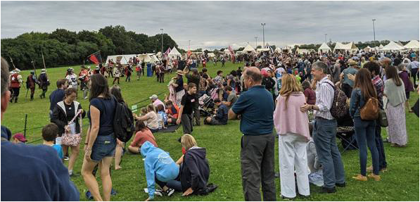
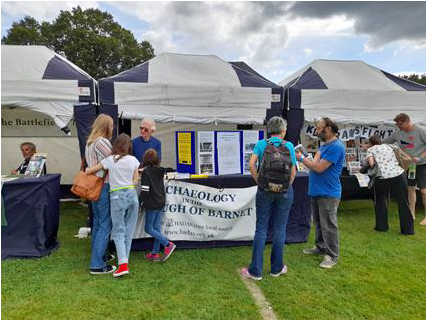
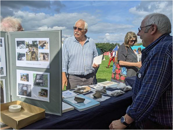
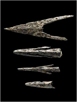
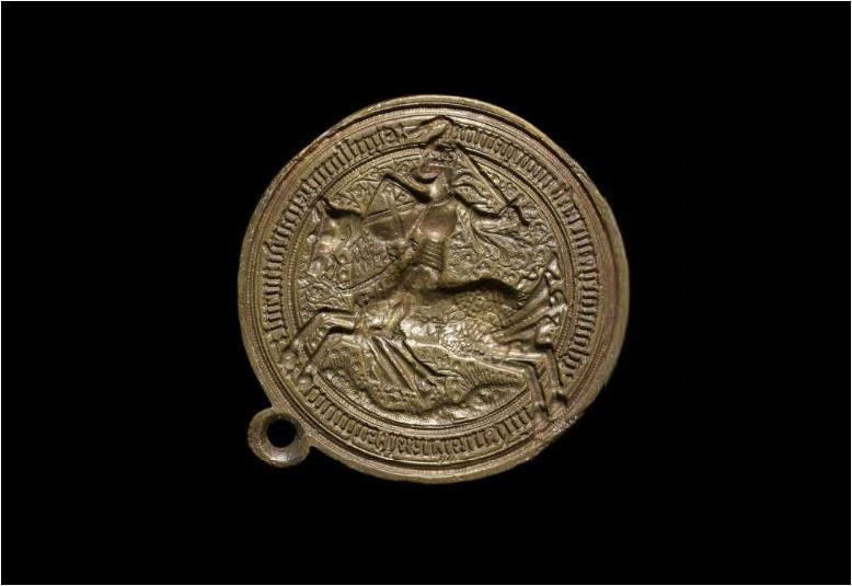
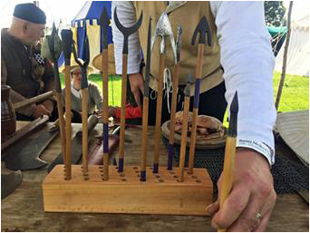
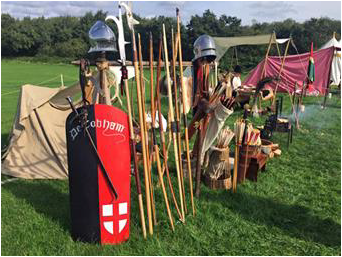
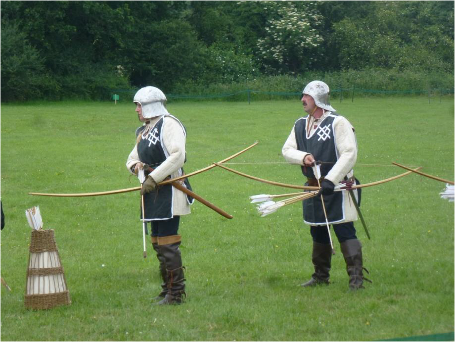
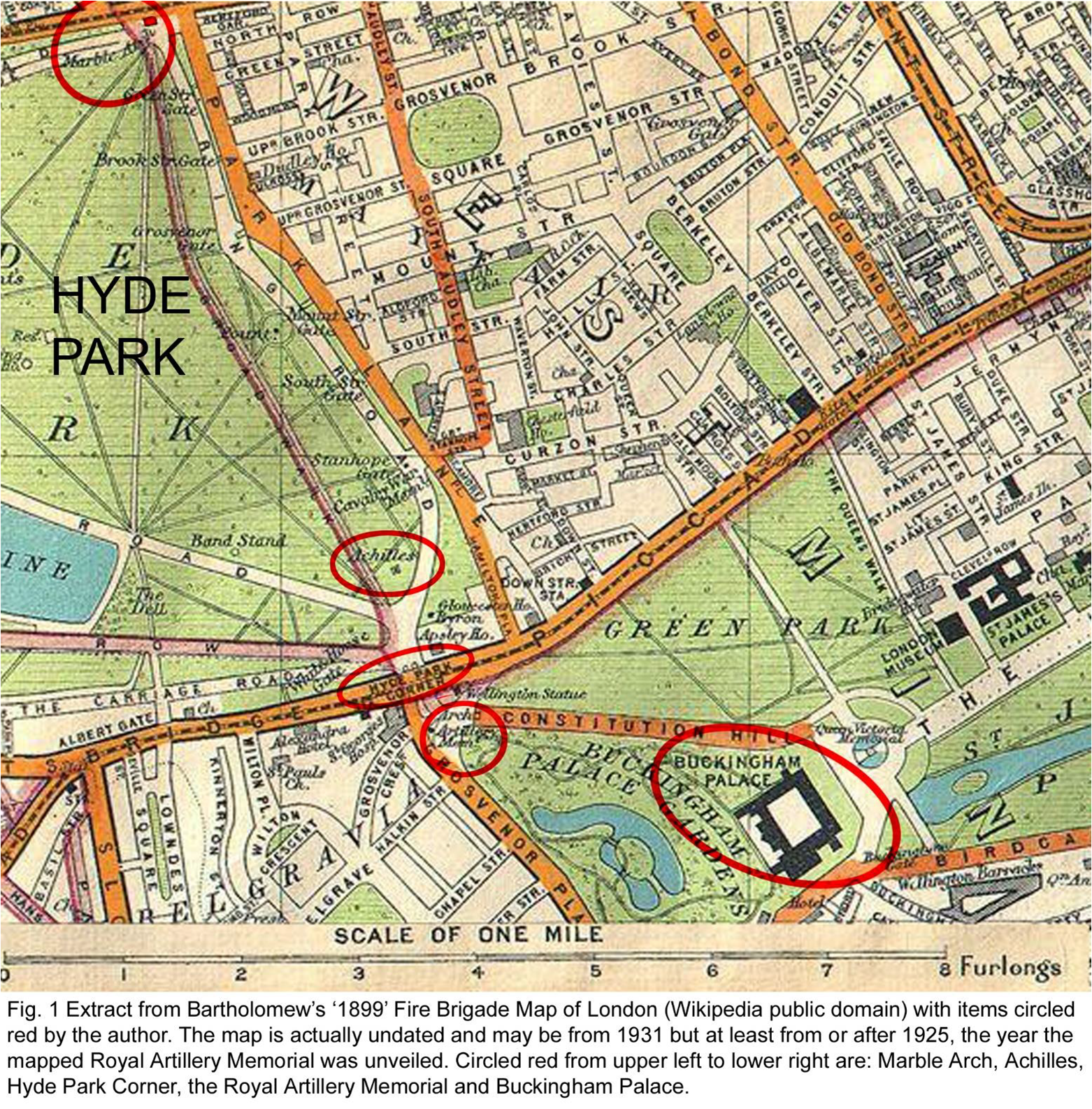
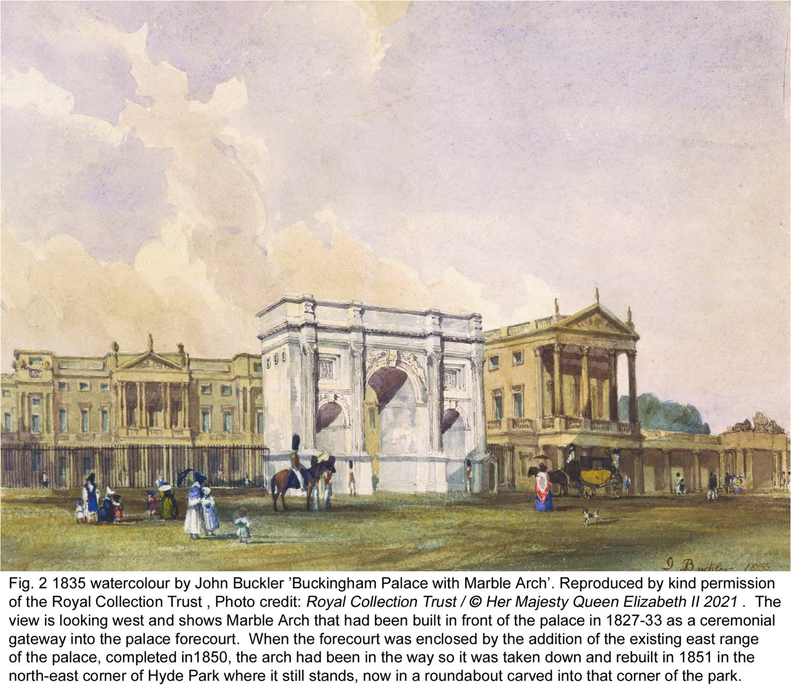
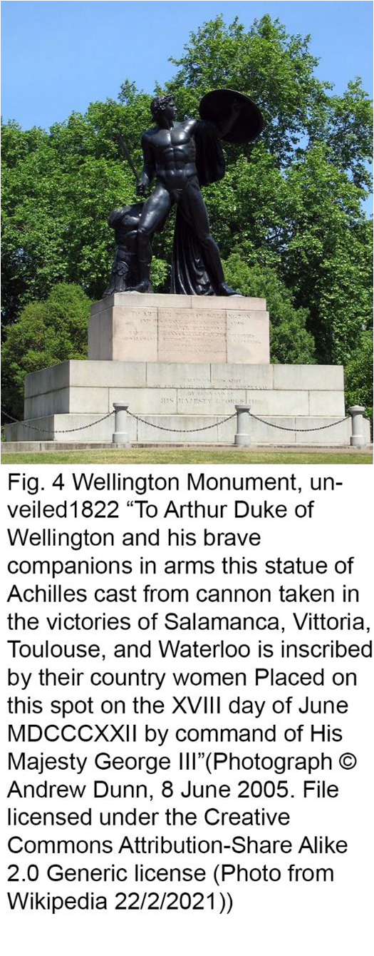
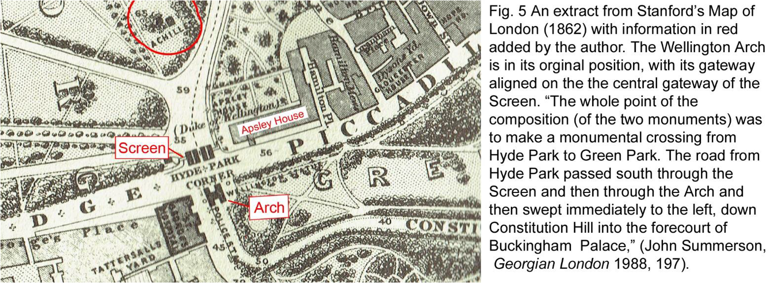
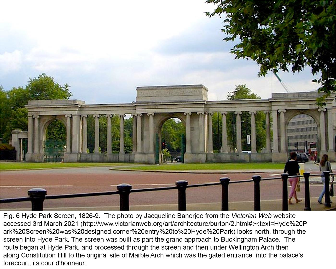
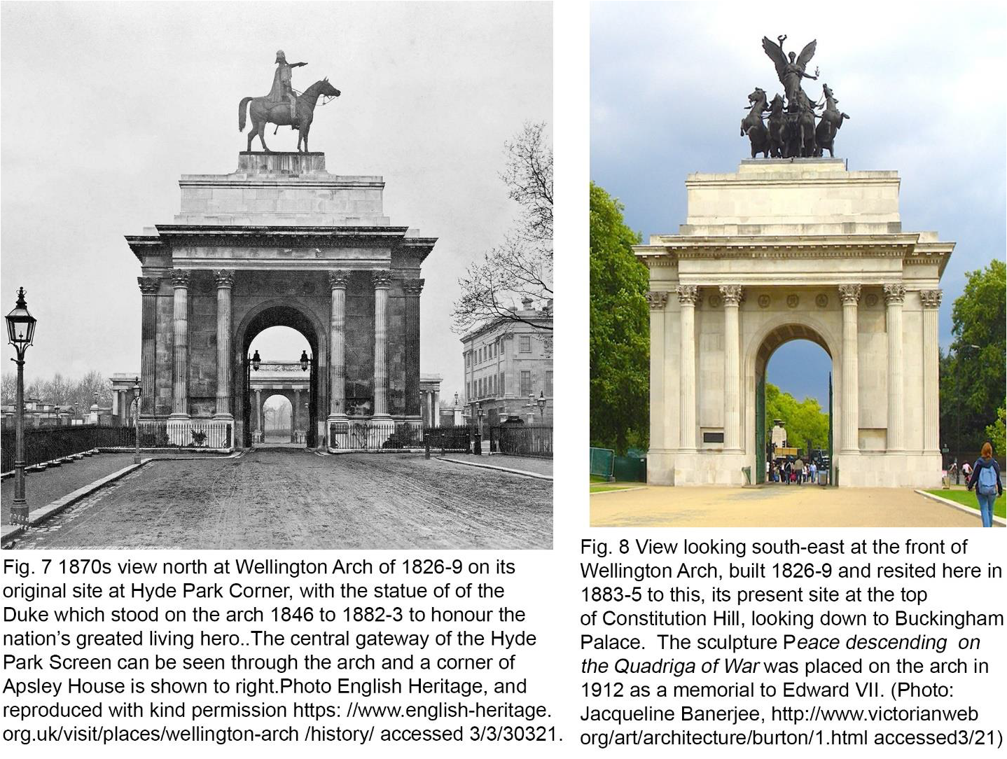
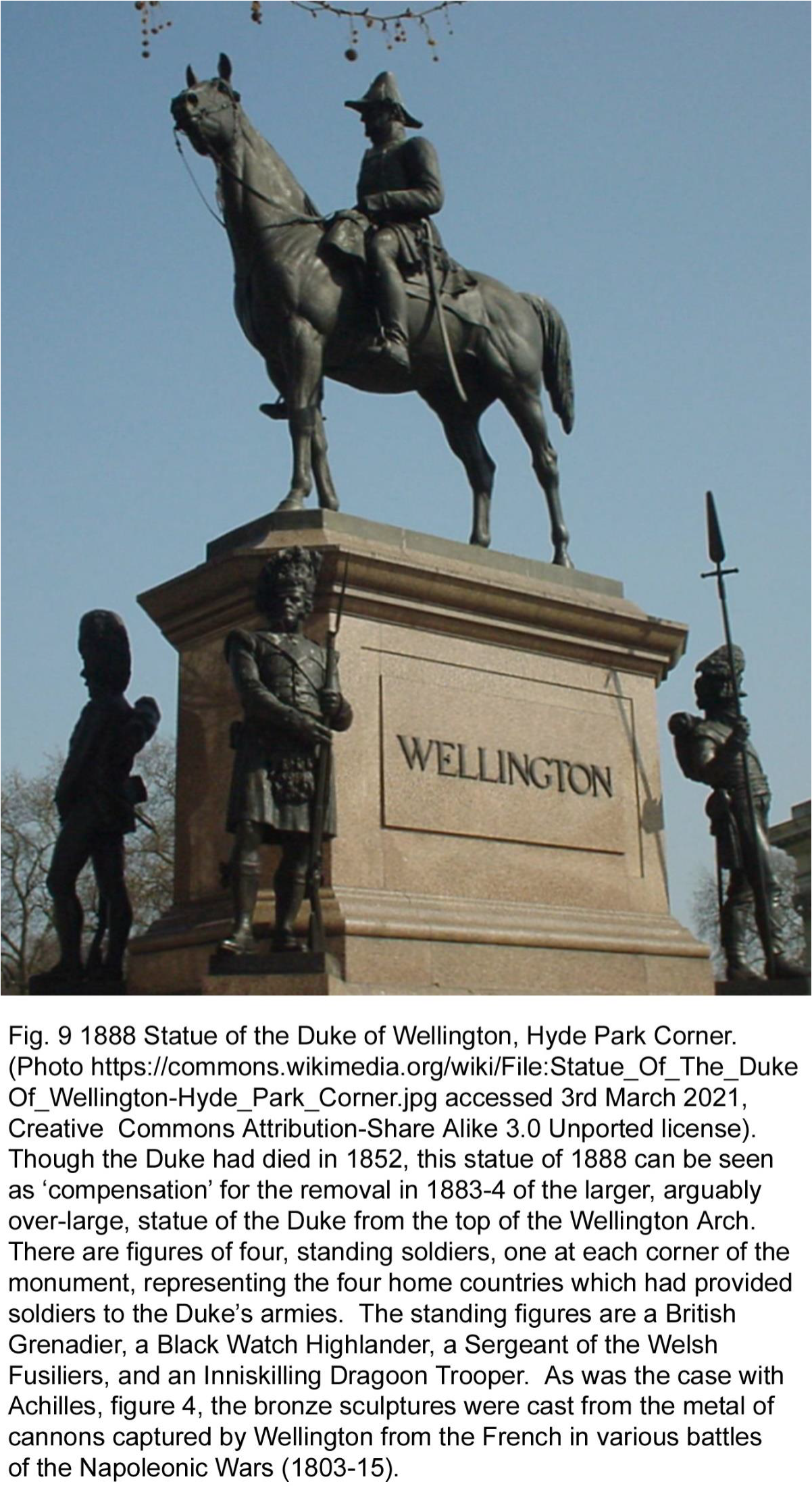
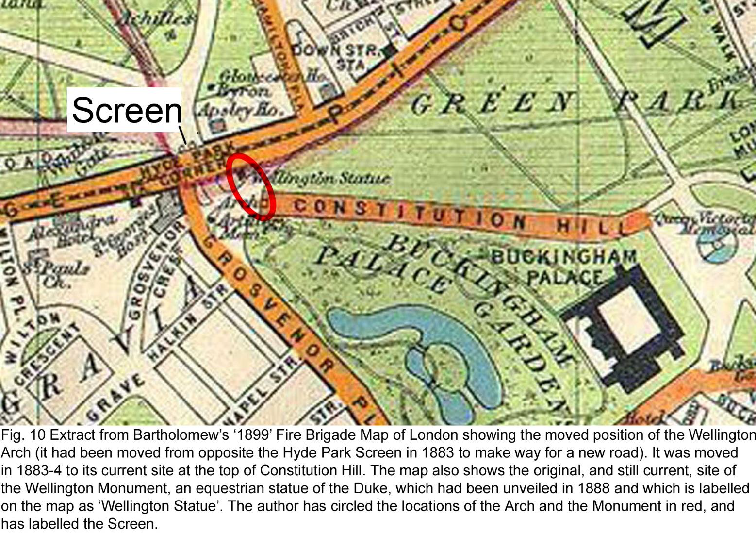
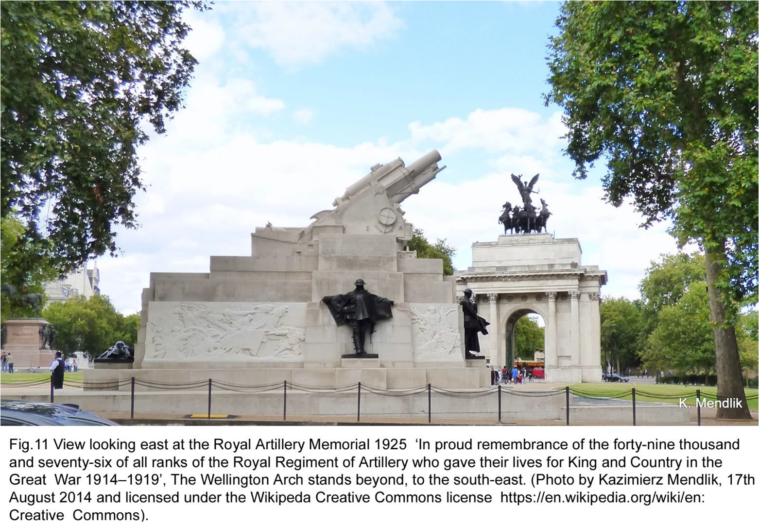
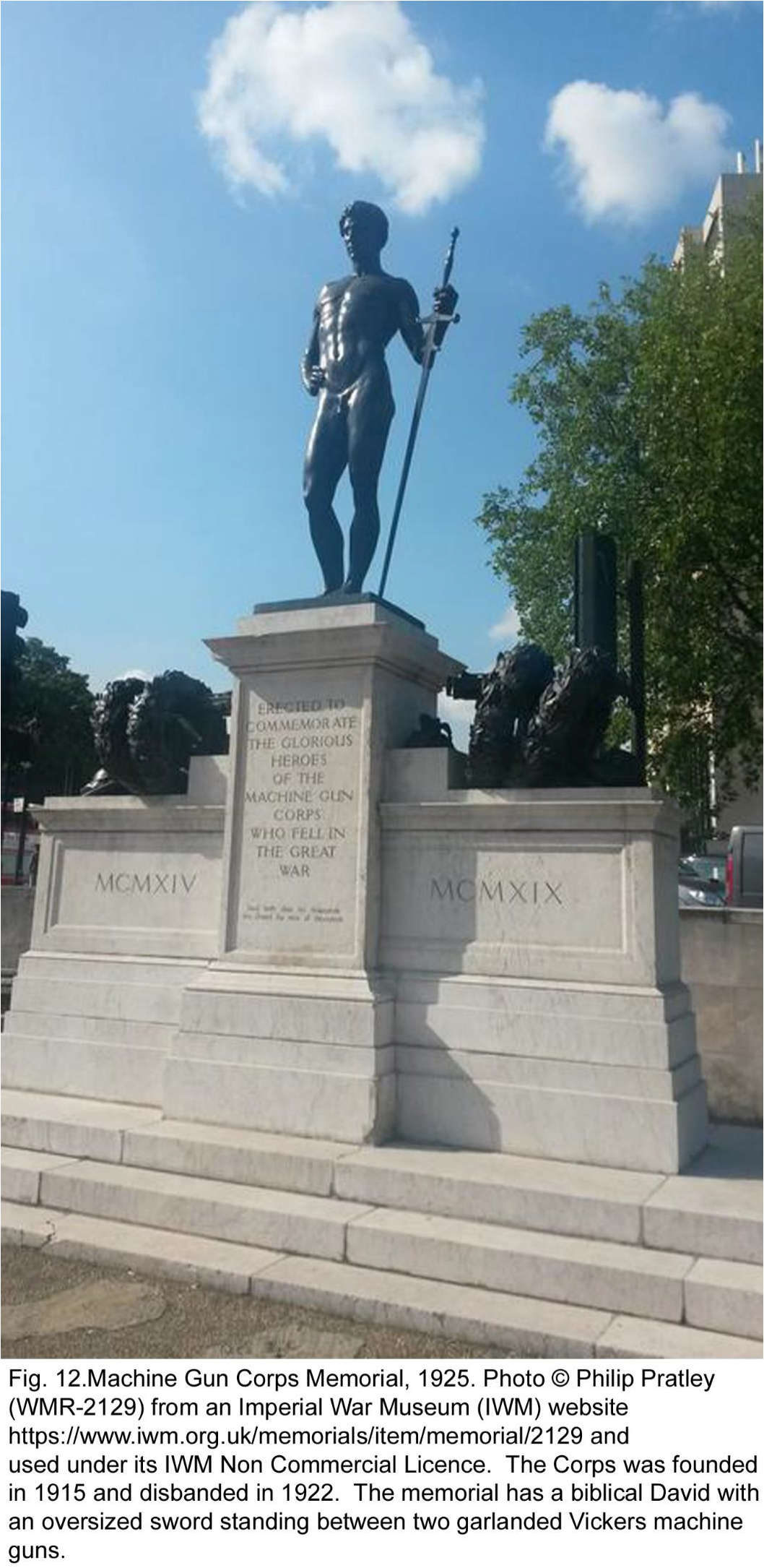
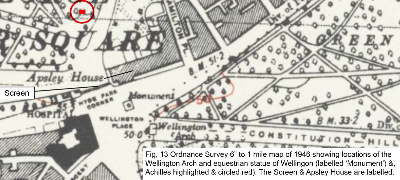
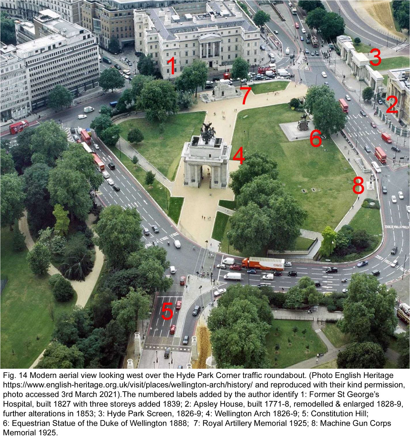
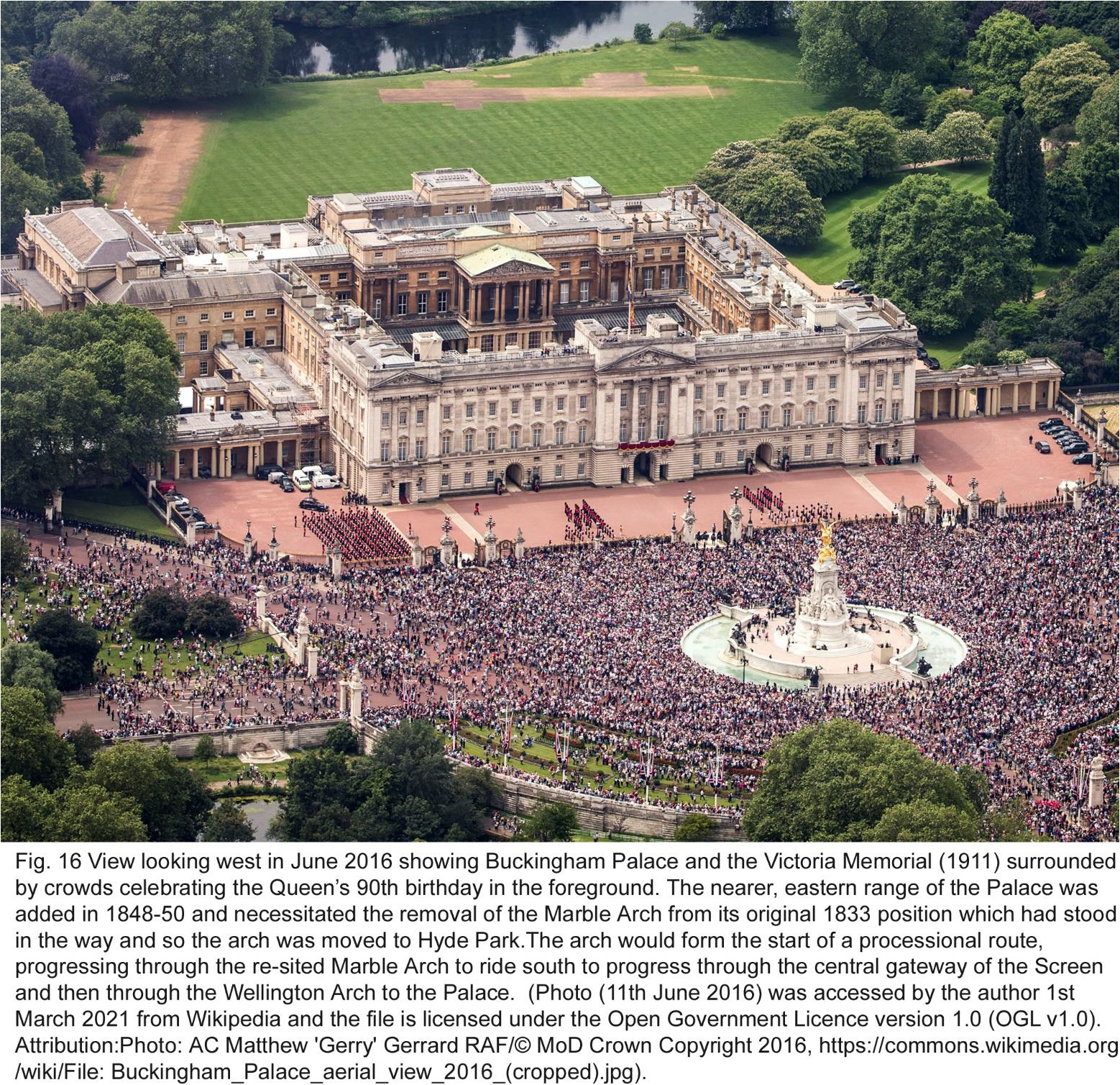
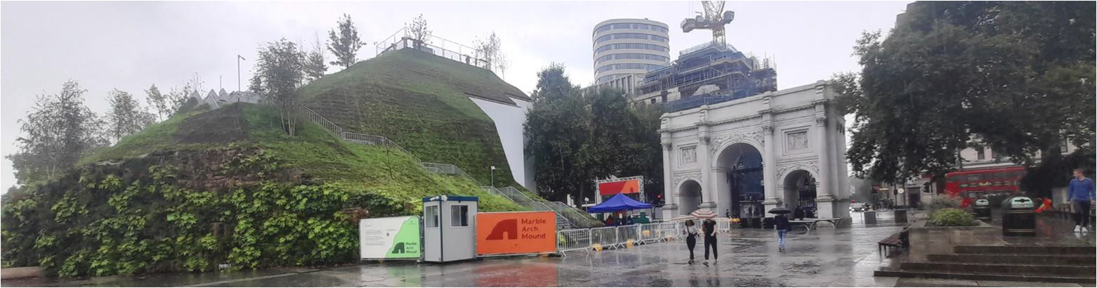

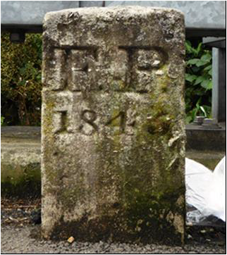
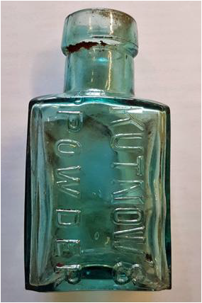
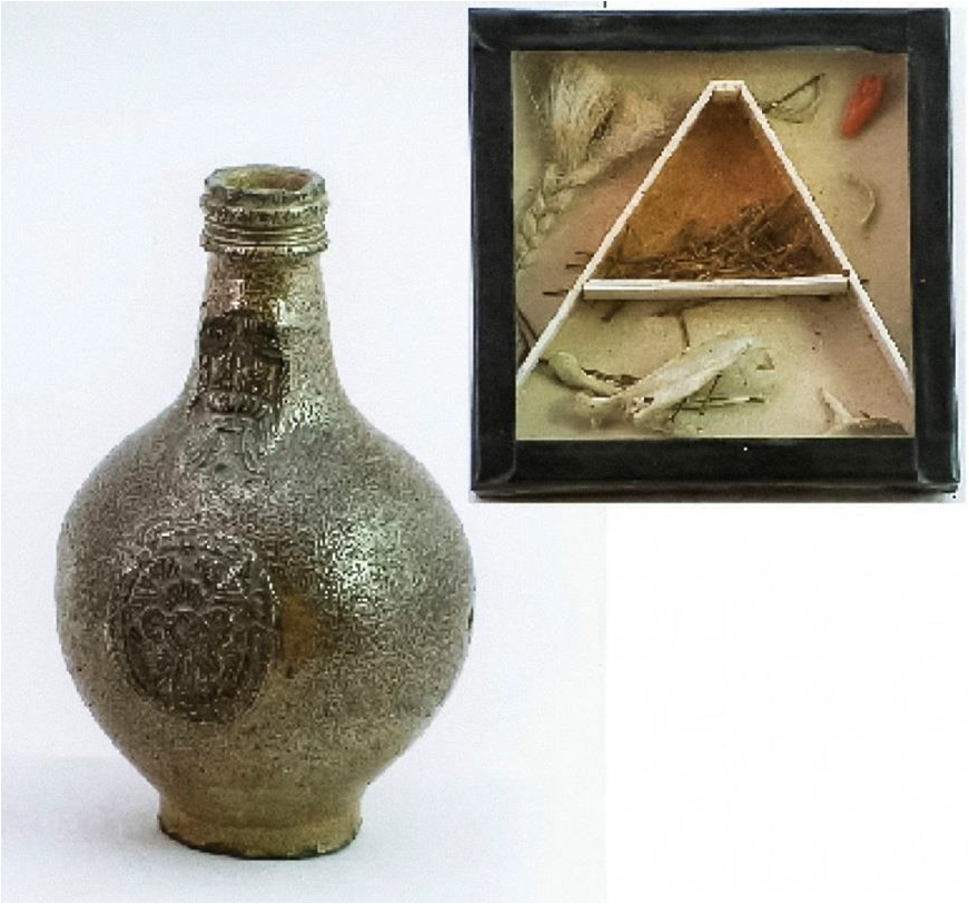
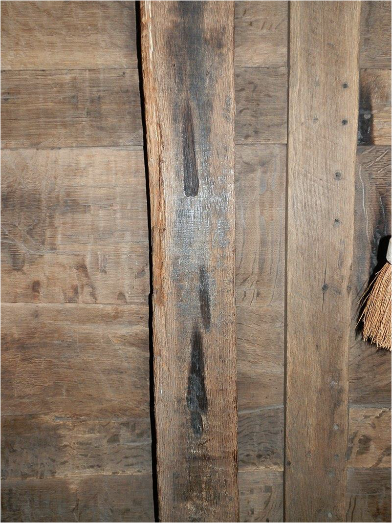
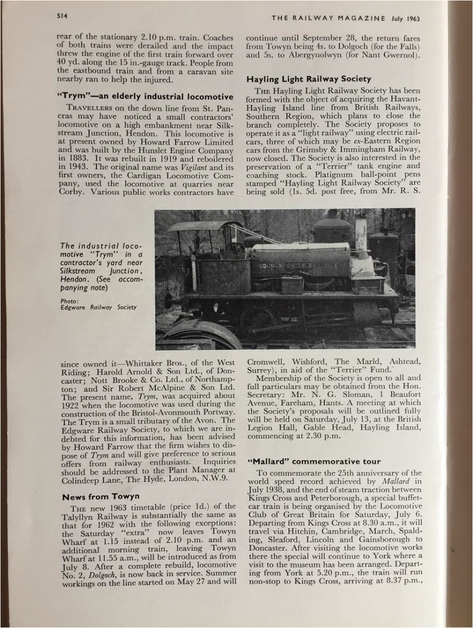
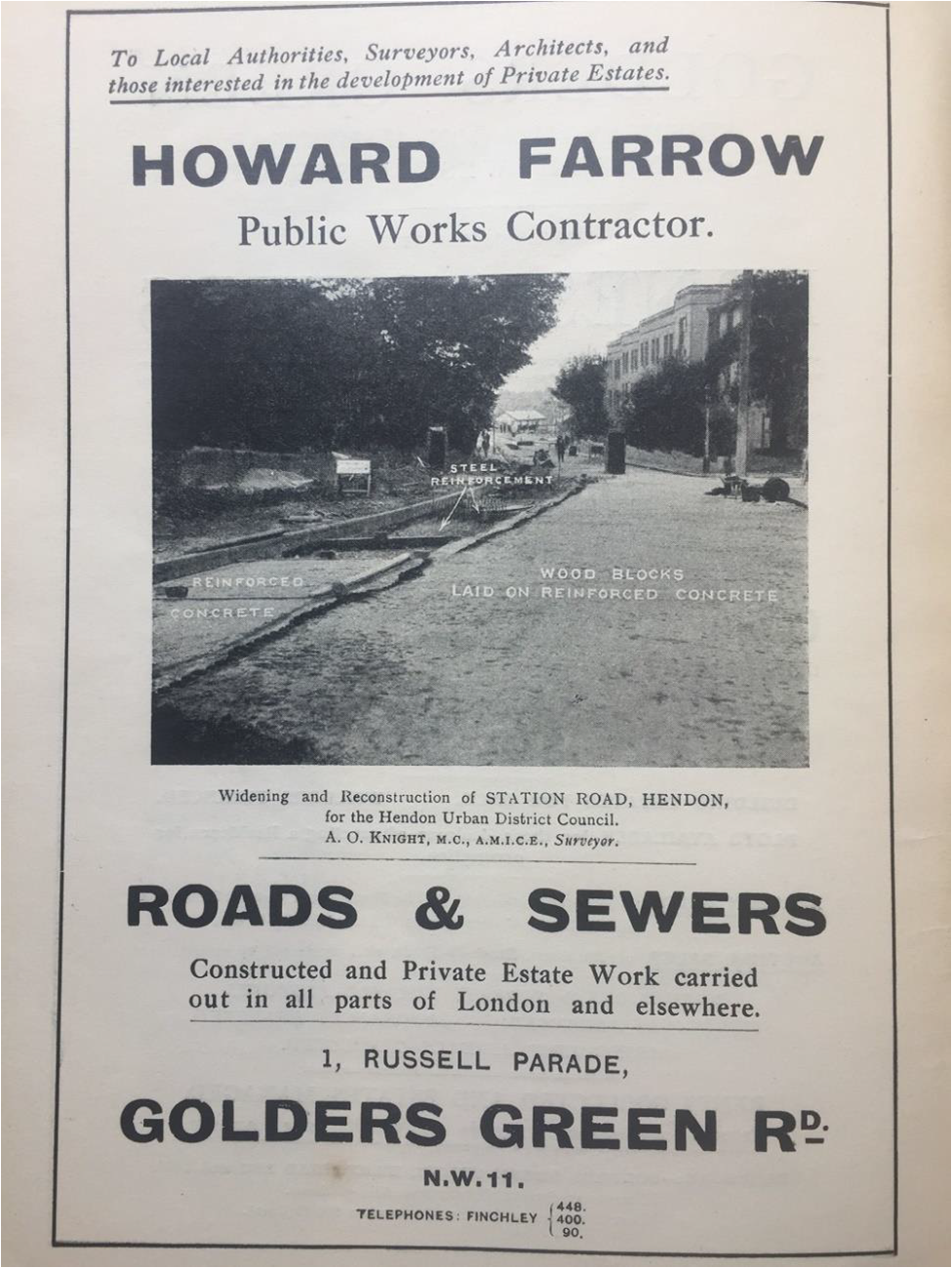
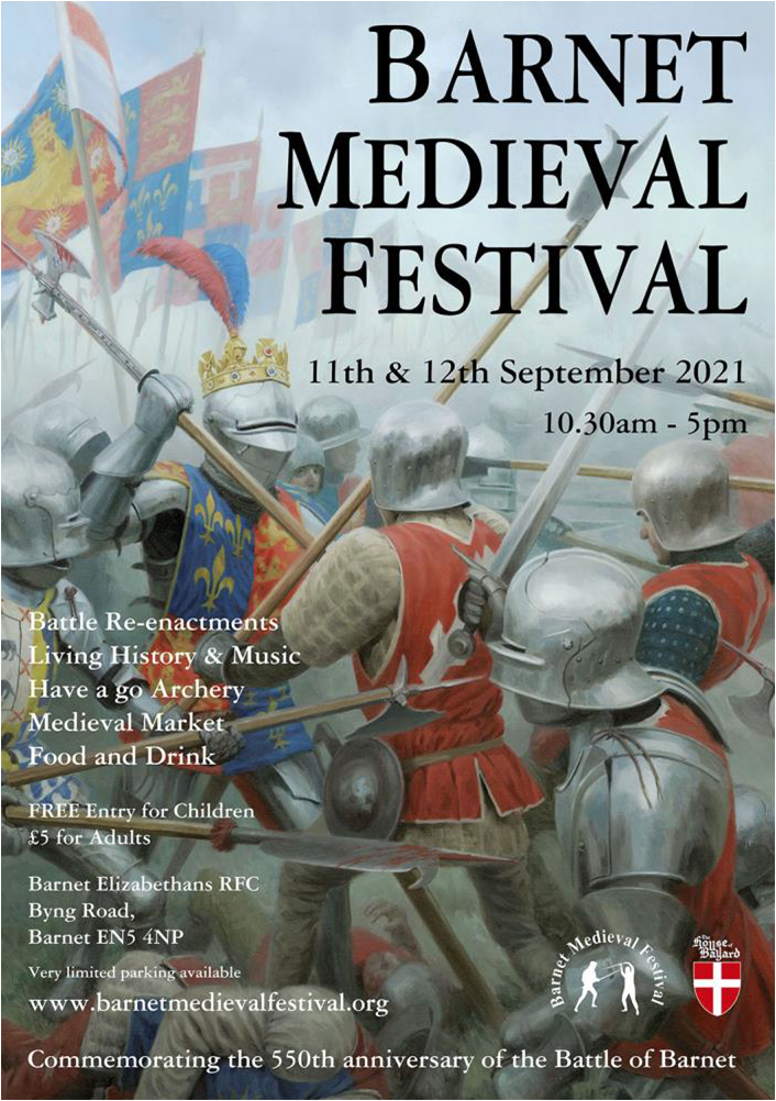

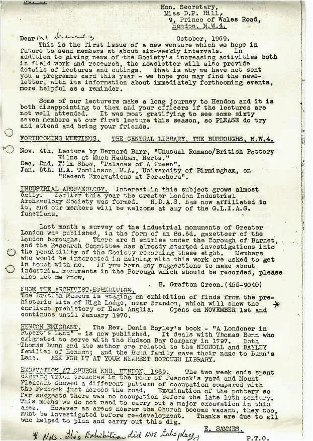
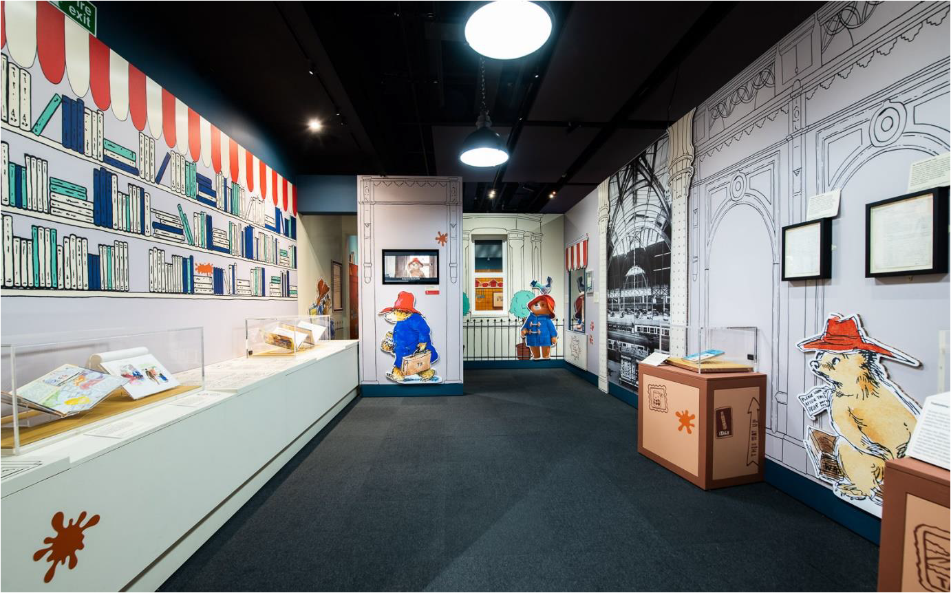
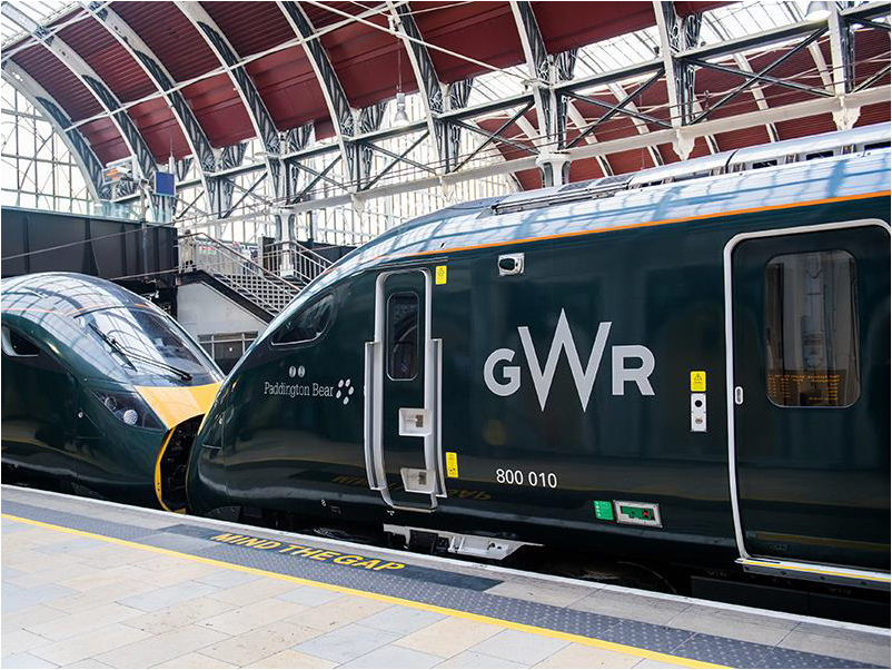
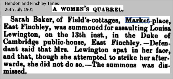
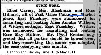
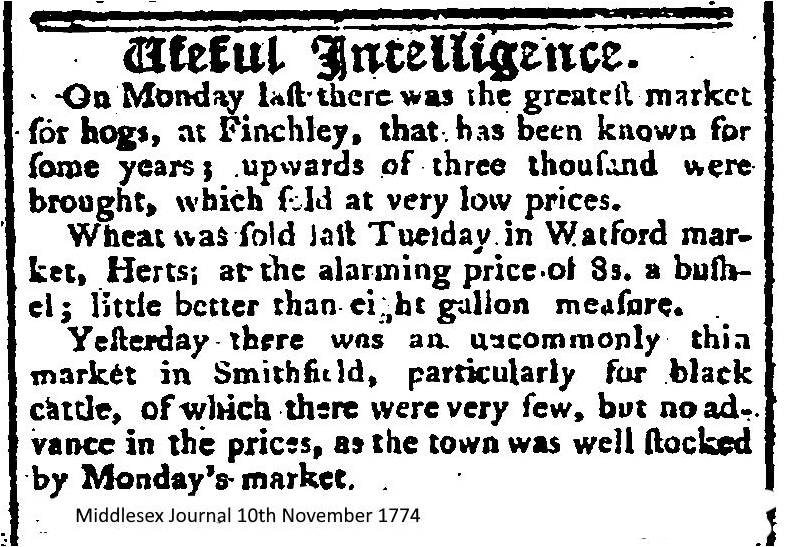
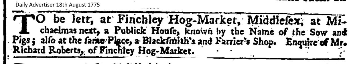
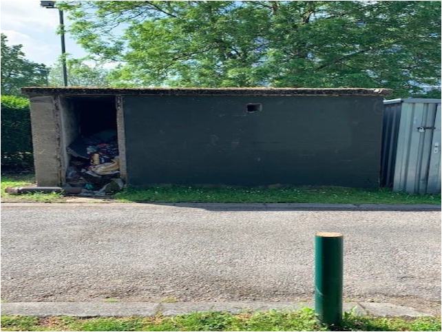
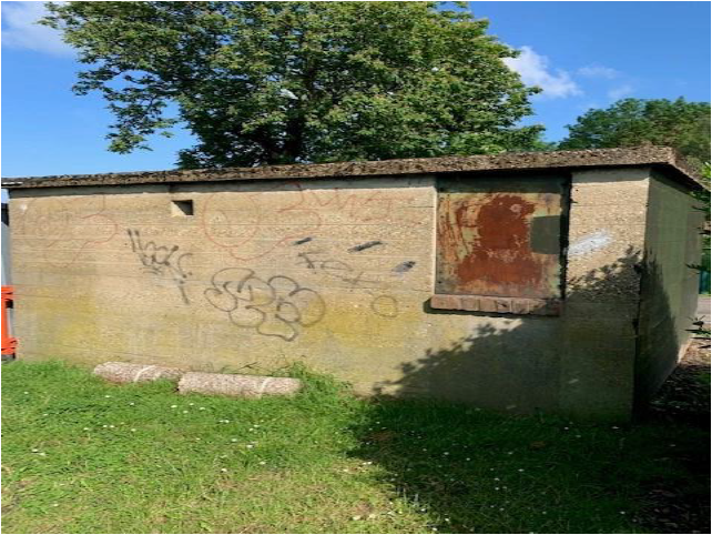
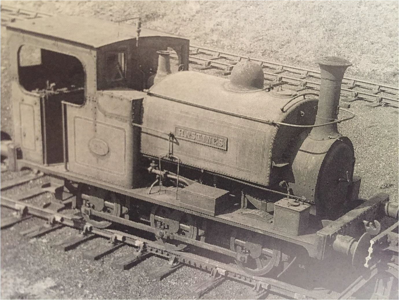


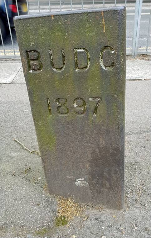
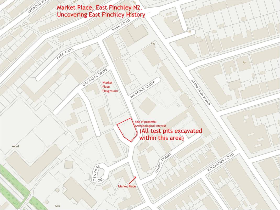
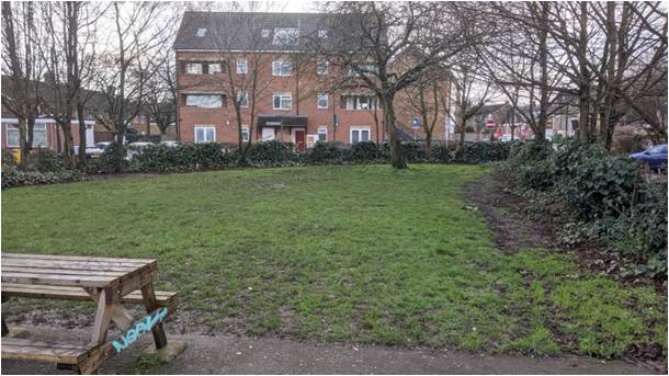
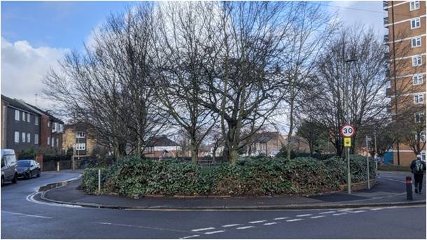
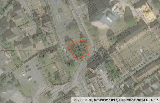
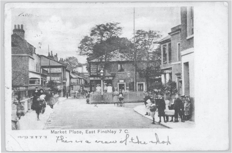
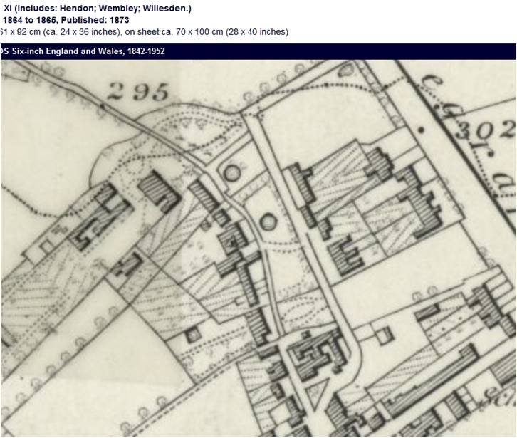
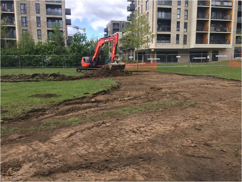
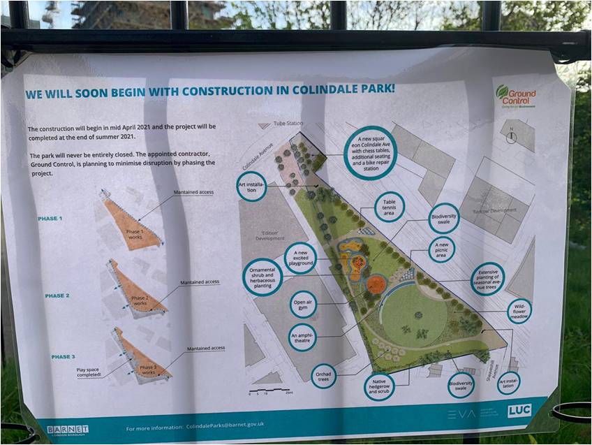

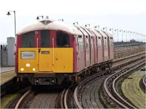
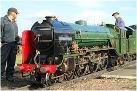
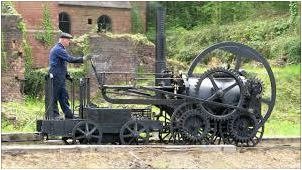
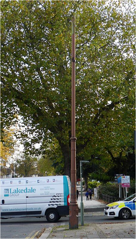
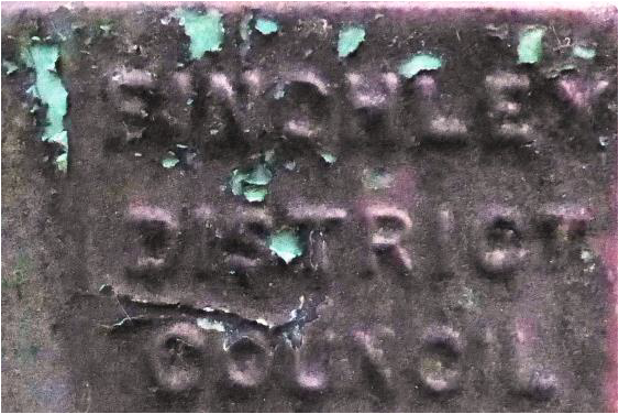
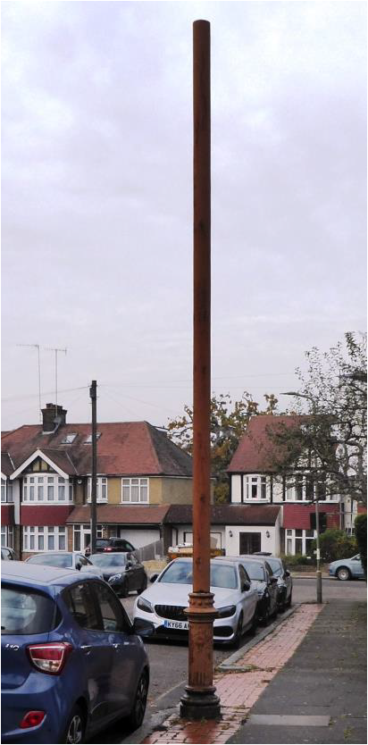
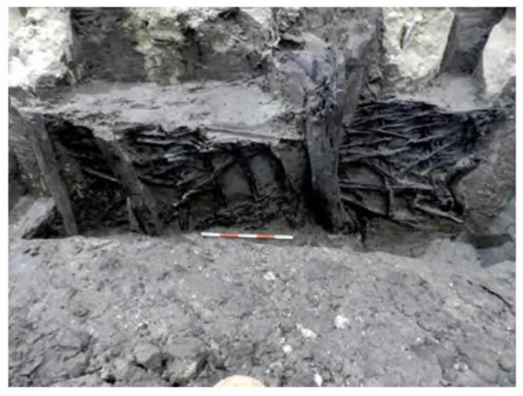
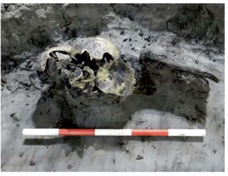
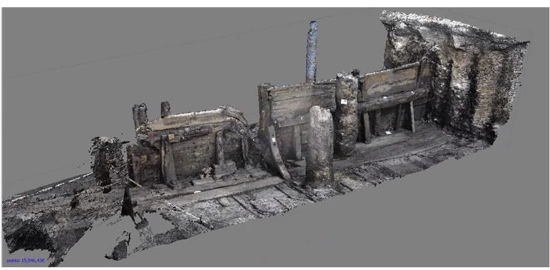
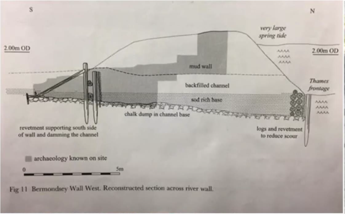
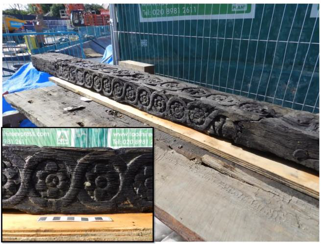
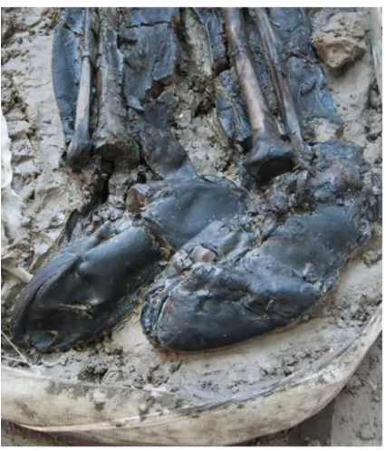

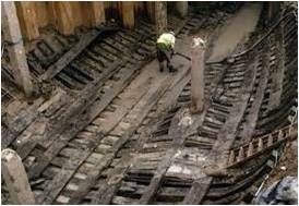

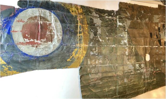

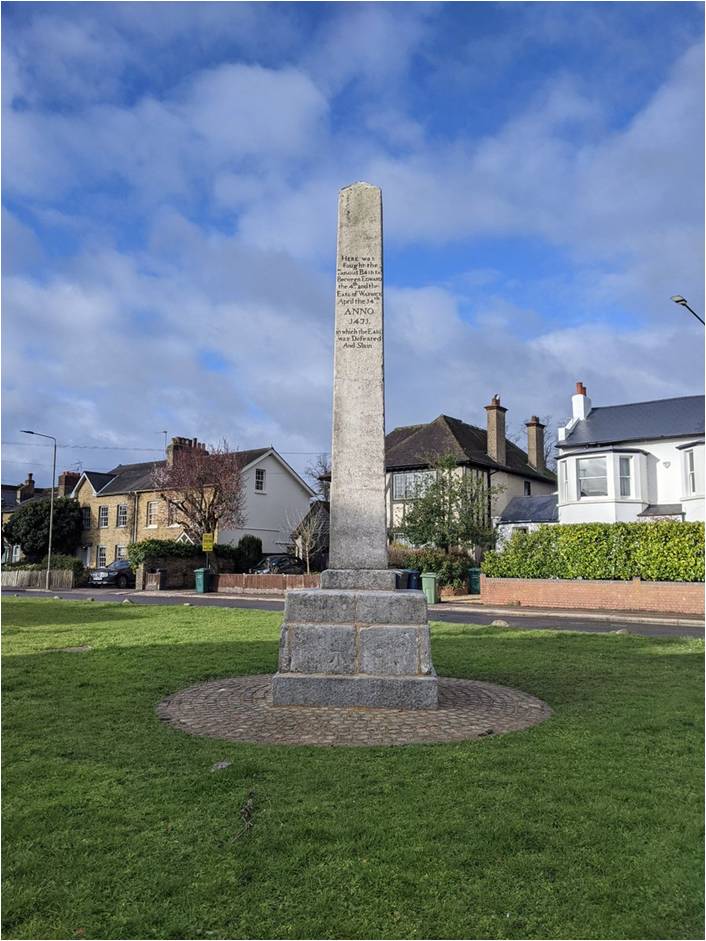
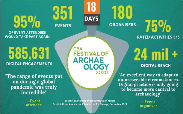

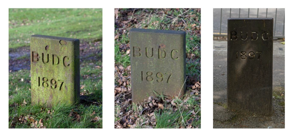
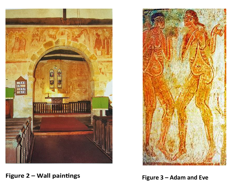

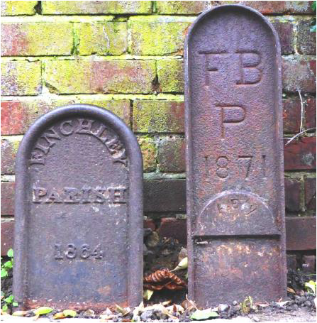
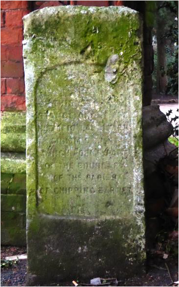
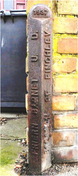
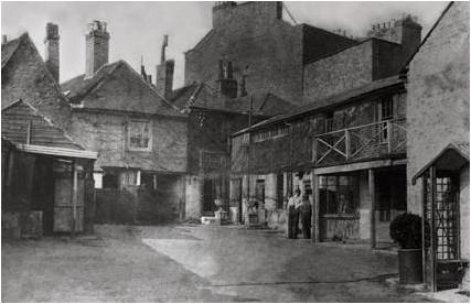
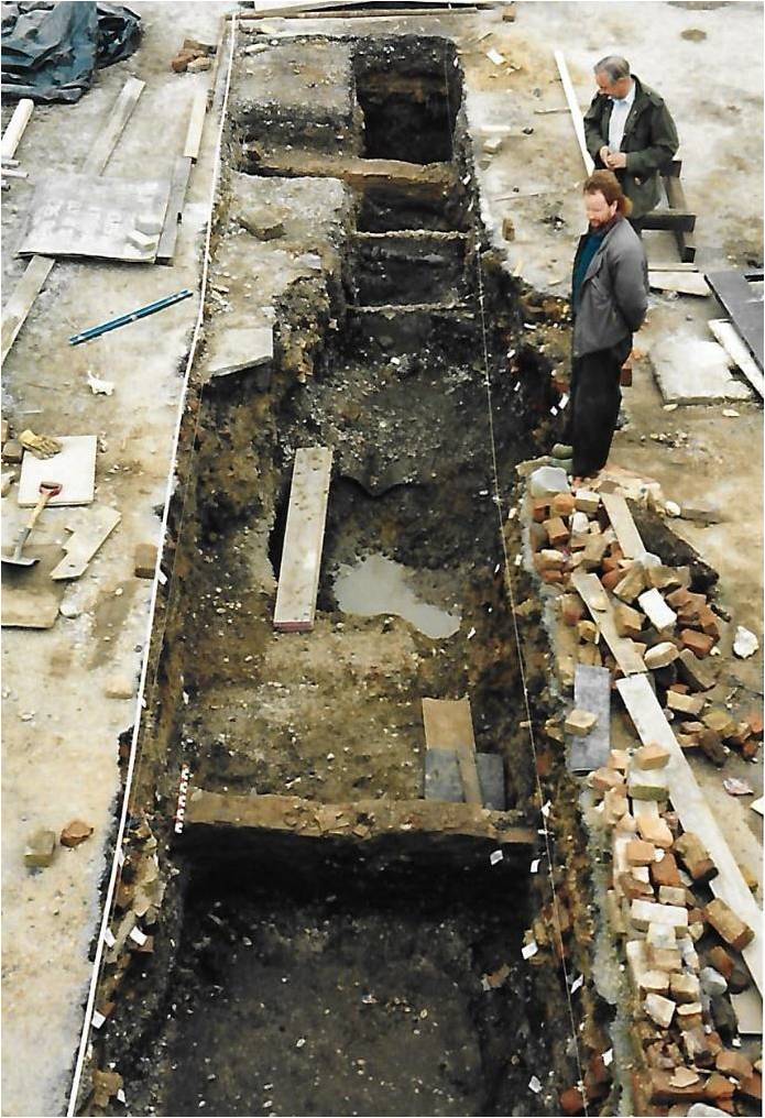
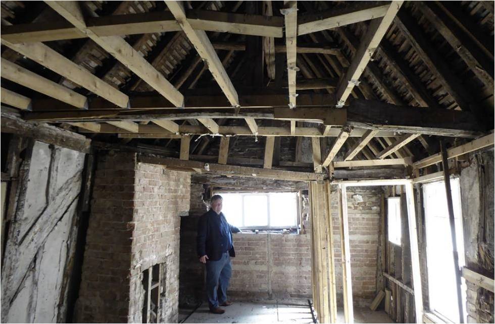
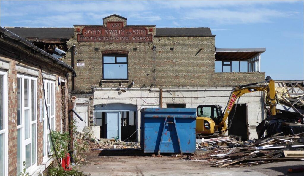
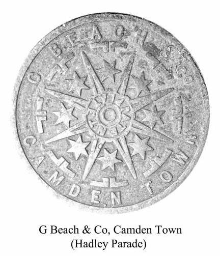
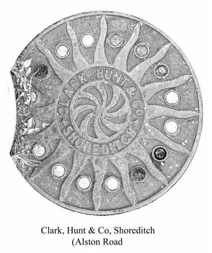
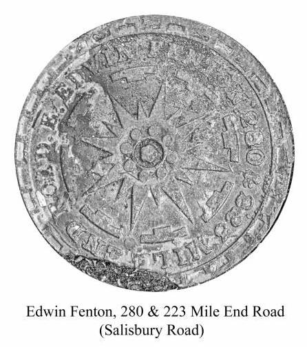
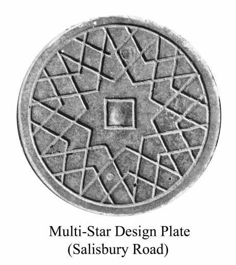
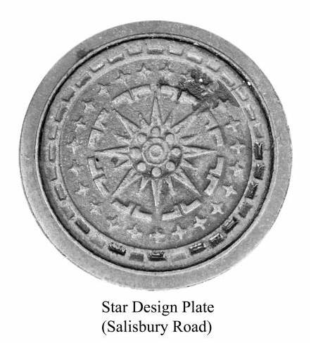
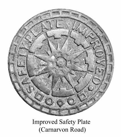